The Historical Locations of Billiluna Homestead in the Kimberley Region of Western Australia
Introduction
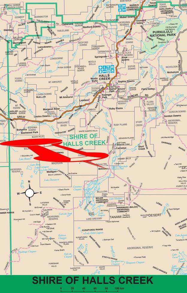
Billiluna is in the northeast of Western Australia, 170 kilometres by road south of Halls Creek. It is today, depending on your direction of travel, the first or last trace of civilisation on the Canning Stock Route. A modified map of the Shire of Halls Creek, WA, at 2002 with the location of Billiluna indicated is shown at Figure 1 below.
Natmap’s Activities in the Billiluna Region
Natmap’s supervising surveyor Howard Angas Bill Johnson arrived at Billiluna Homestead in October 1962 with just a little petrol left and almost no food (Ford, 1979). Johnson had just completed the reconnaissance of the Canning Stock Route, from Wells 35 to 51, of the Well 35 to Halls Creek traverse section of the national geodetic survey. After travelling across country from Callawa homestead, he drove alone northwards from Well 35 generally on or close to the Canning Stock Route in an AB120 series International four wheel drive light truck. The route he chose was primarily for the later Natmap observing party to follow to access the highest points of the terrain that would give line of sight along the geodetic traverse route. To avoid the observing party having to cart water over great distances, Johnson also inspected and reported on the condition of wells on the Canning Stock Route (CSR) that were conveniently located in relation to the proposed traverse route. However, by Well 51 the higher terrain features needed to carry the survey traverse were away generally to the north-west. Johnson therefore took his reconnaissance route in that direction enabling the proposed traverse to make the necessary connection to the existing survey around Halls Creek.
Johnson was aware that significant time and vehicle wear and tear could be saved if the survey points on the geodetic traverse south of Minnie Range could be accessed via Well 51 from the graded road that then existed between Billiluna and the Balgo Mission. However, a suitable track across approximately 30 miles (48km) of country between the Billiluna-Balgo road and Well 51 did not then exist. Johnson’s own travel route northwards from Well 51 precluded his reconnaissance for such a new connecting track. Nevertheless, Johnson arranged a contract for Mr Bill Moyle of Carranya Station to undertake the scraping of the new track to Well 51 and to then continue with further track work southwards to Well 45. Moyle completed the track scraping in early 1964, just prior to work commencing on the Natmap geodetic survey traverse from Halls Creek to Well 35. The unofficially named Moyle’s Track ran from the vicinity of Old Billiluna [Homestead] to Well 45, bypassing Wells 47 and 46 to the east (McLean and Wise, 2012). Please refer to Figure 2 below for a map showing the 1964 locations of the then Billiluna-Balgo road and Moyle’s Track as far as Well 51.
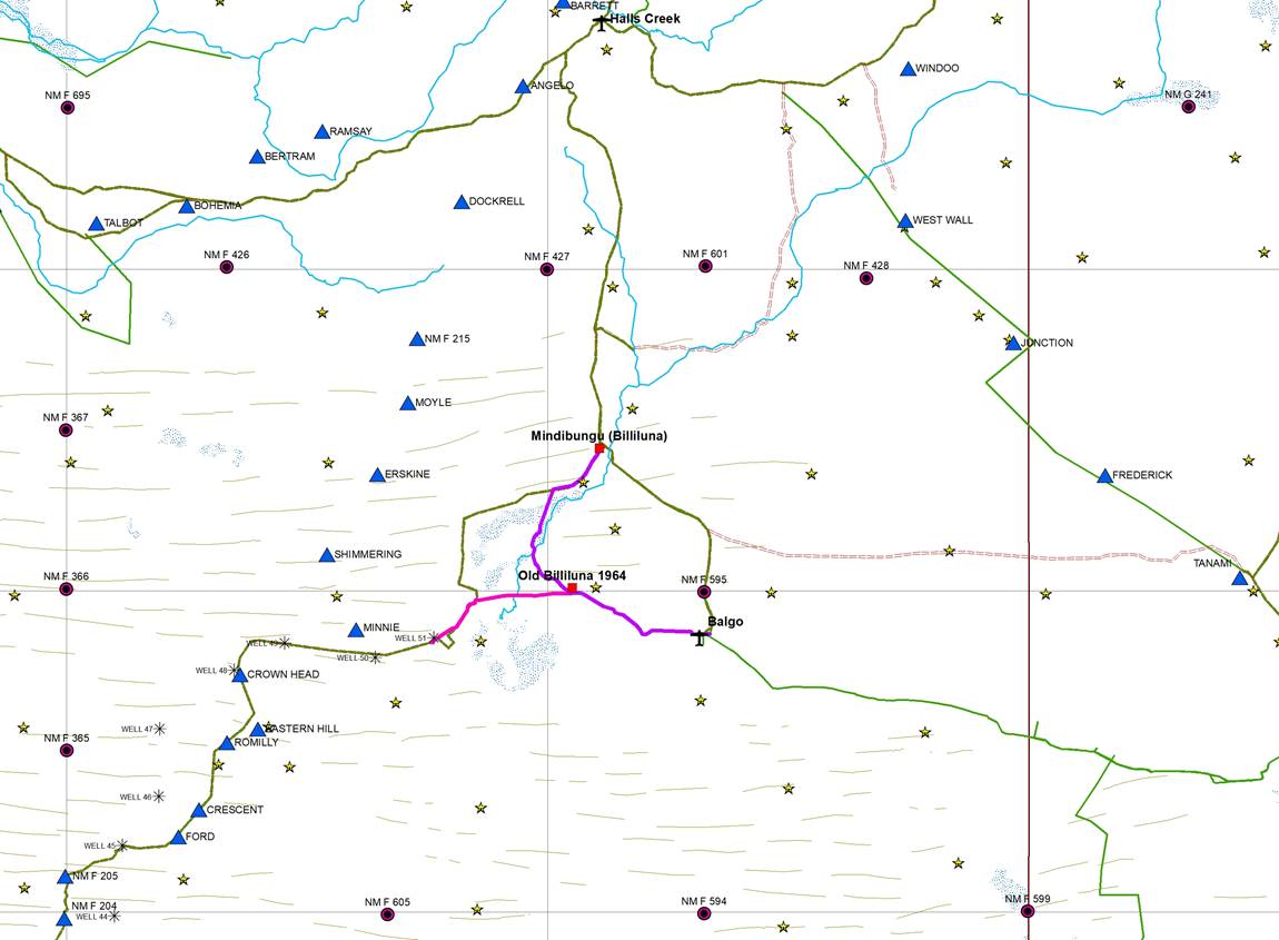
Figure 2 : Map of Billiluna region showing Natmap’s survey activities.
Astrofixes (yellow stars), geodetic traverses (blue triangles), control stations fixed by Aerodist (red circles), levelling traverses (green and orange depending on modern track use),
Billiluna to Balgo road in 1964 (purple) and Old Billiluna to Well 51 section of Moyle’s track in 1964 (pink).
Not shown for clarity, are the various eras of aerial photography and east-west terrain profiles at approximately 10 kilometre intervals over the region and sundry other survey activity.
In previous years, mainly National Mapping, the Lands Department of Western Australia and the Army Survey Corps, undertook astrofix work to provide horizontal control for the uncontoured, national R502 1: 250,000 scale map series. In the Billiluna region, the astrofix sites were accessed by both vehicle and helicopter (Casey and Nelligan, 1956). To provide horizontal control for the later National Topographic Map Series (NTMS), which was to be contoured, in 1969 a Natmap Ground Marking field party operated in the Billiluna region. With the aid of helicopter support, this field party established 3 mapping control stations out of Balgo, before moving to Well 51 to establish 2 more stations to the west. Finally moving to Christmas Creek via Halls Creek, the party established 3 further stations before moving further west. To obtain the coordinates of these control stations, an Aerodist (airborne distance measuring) field party operated in the region in 1971. While the airborne measuring aircraft VH-EXZ operated out of Balgo, two man parties operating the remote equipment were positioned by helicopter from NM/F/595 near Balgo and NM/F/366 to the west of Twin Heads in the Great Sandy Desert. These remote parties occupied the mapping control stations established in 1969. Please refer to Figure 2 above for a map of Natmap’s survey activity in the Billiluna region.
In the late 1960s, the vertical control network was initially established by Department of Interior levelling parties and later levelling parties under contract to Natmap. In the Billiluna region the major levelling traverses followed the then Canning Stock Route between Halls Creek and Wiluna and the then Tanami Road via Balgo and Rabbit Flat to Alice Springs. In the 1970s, Natmap’s levelling field parties connected both Aerodist control stations NM/F/595 and NM/F/366 to the levelling network.
For generating the contours from aerial photography, the required height control points were extracted from terrain profiles. The terrain profiles were acquired using Natmap’s airborne Laser Terrain Profiler, later branded WREMAPS1, along predefined flight paths. Natmap’s terrain profiling field party with the laser profiling system mounted in its contracted aircraft VH-EXP operated from Halls Creek in 1973 and Balgo in 1974.
Maps produced pre and post this Natmap survey activity have the location for Billiluna homestead depicted in different places depending on the date of the mapping. This paper describes the history behind those various sites for Billiluna homestead.
Historical setting
Between the 1856 and 1897 exploration of the north of Western Australia, first by Augustus Charles Gregory (1819–1905), please refer Annexure A, and then David Wynford Carnegie, (1871-1900), please refer Annexure B, came the cattlemen. At this time the only mapping was that of the explorers which showed Sturt Creek, with Mount Mueller (today’s spelling) and Mount Wilson to its east and south respectively, named by Gregory. The Sturt was shown as draining into the Salt Sea; later named Gregory’s Salt Sea and today Lake Gregory. Please refer to Figures 3 and 4 below. Prior to Carnegie however, in mid-1890 in the report on the Sturt Creek country, requested by the Resident Magistrate in Wyndham, it was stated that : We [people from then Denison Downs Station] have been 80 miles down the Sturt Creek to the Salt Lake, but could get no water low down, so had to return….

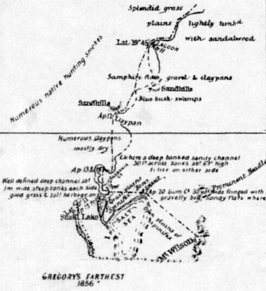
Figures 3 and 4 : Left is a section of map after the 1856 exploration by Augustus Charles Gregory.
Right is a section of map after the 1897 exploration by David Wynford Carnegie.
An 1896 Map of Western Australia, by the then Western Australian, Department of Lands and Surveys, showed little more than Gregory’s work in a State context. Please refer to Figure 5 below. The 1903 Map of Western Australia, also by the then Western Australian, Department of Lands and Surveys, showed the same topography as in the 1896 map, but had the area covered by pastoral leases shaded in green. In the region of Sturt Creek, the pastoral leases extended down both sides of the creek as far south as today’s Mindibungu (Billiluna) as shown in Figure 6 below. This map still showed Denison Downs Station, which had been in operation for some fifteen years, although it is understood to have been renamed Sturt Creek Station, in 1902. Sturt Creek Station today, was also known as Sturts Creek and Lower Sturt Creek during its history. Sturt Creek Station was purchased by the Australian Investment Agency (AIA, also known as the Vestey Group, Vestey Group Limited and just Vestey’s, please refer to Annexure C for details) in 1914 and was one of the many northern Australian cattle stations purchased by AIA to supply their lucrative frozen meat and meat canning (bully beef) industry during and after the First World War. Sturt Creek continues today as a property of S (Sidney) Kidman & Co Ltd, as an outstation of Ruby Plains Station. Figure 7 below is a section of the 1921, Map of Western Australia by Hope and Klem, showing the principal sheep and cattle stations around Sturt Creek.
To get their cattle to the southern markets from this then extremely remote region of Western Australia, Government appointed surveyor Alfred Wernam Canning (1860-1936) led an investigative party in 1906-07, to establish the feasibility of a stock route. Initially constructed as the Wiluna - Kimberley Stock Route during 1908-10, the route was formally renamed the Canning Stock Route in February 1967 but had previously been referred to by that name for many years. A party of 26 men under Surveyor Canning carried out the work.
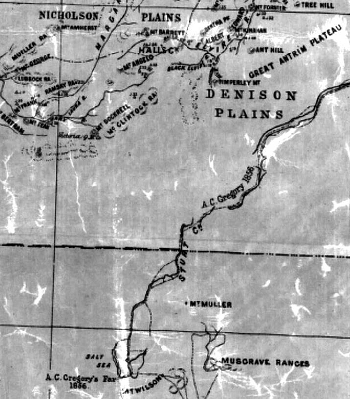
Figure 5 : Section of an 1896, Map of Western Australia, by the then Western Australian, Department of Lands and Surveys.
Courtesy National Library of Australia nla.obj-231374441.
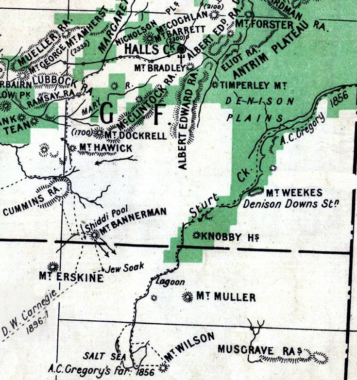
Figure 6 : Section of a 1903, Map of Western Australia, by the then Western Australian, Department of Lands and Surveys, with the then area covered by pastoral leases shaded in green.
Courtesy National Library of Australia nla.obj-233468118.
The Canning Stock Route covered a distance of about 1,800 kilometres across Western Australia's semi-arid and desert country from Wiluna (in the Eastern Goldfields about 700 kilometres north-east of Perth) to Halls Creek in the East Kimberley (about 350 kilometres south of the port of Wyndham). At the time the stock route was in use for droving, the Halls Creek township was about 15 kilometres east of the present day Halls Creek. After an airstrip was built on the present site in 1948, the old town was gradually abandoned and regrew at the present location of Halls Creek. Today’s Old Halls Creek was deserted by 1954.
Canning provided for the stock route to be 400 chains or five miles (8 kilometres) wide. The wells and other waters were not always in the centre of this corridor that ran from Wiluna to Lake Gregory (near Well 51) and then mostly along Sturt Creek to Flora Valley and on to now Old Halls Creek township. North of the confluence of Sturt Creek and Wolfe Creek (Wolf Creek on early maps including Canning’s survey) the stock route was only 100 chains (1.25 miles or 2 kilometres) wide. Canning’s route (to state the obvious) ran from well to well. While the route is shown by lines drawn on maps it was never marked or fenced and until motor vehicles took to regularly traversing the route, which then marked the ground, the route was just a series of watering points about a day’s droving apart. Canning however, did blaze trees along the route and took observations for latitude at significant features. Canning’s survey found that while below where the Sturt Creek pastoral lease then ended there was sandridge country, further south again however, around Gregory’s Salt Sea there was good pasture.
In November 1915 it was reported that Ludlow J ffrench (surname spelt with no capital) had been appointed manager of the Sturt Creek station then the property of Vesty’s. Matt Savage (Willey, 1971) recalled that in 1916, during Ludlow ffrench’s time as manager of Sturt Creek he and another stockman went out to look at country and water and were told to follow Sturt Creek to the south-west as far as a great salt lake on what is now Billiluna station. At that time the country was unoccupied and almost unknown.
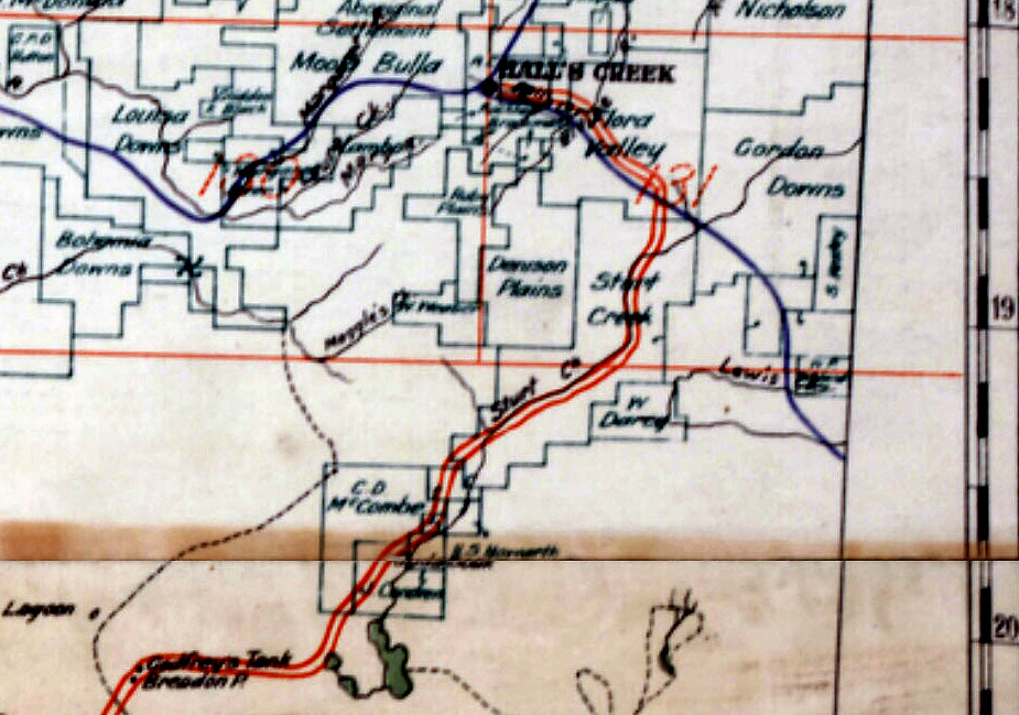
Figure 7 : Section of the 1921, Map of Western Australia by Hope and Klem, showing the principal sheep and cattle stations around Sturt Creek.
Courtesy National Library of Australia nla.obj-229923737.
There were some 35 cattle drives down the Canning, of which 29 were of cattle from Billiluna station. In 1910 cattle drives started but officially the first cattle to head down the stock route was a mob of 150 bullocks that left Flora Valley station around mid-1911. During the 1930s, use of the stock route increased and for the next 20 years at least one mob a year was brought down. Billiluna cattle headed for the southern markets would be assembled at Delivery Plain on Billiluna station, an area just a few kilometres east of Well 51, Weriaddo. Here up to five hundred head would be selected for droving south. It had been found not to be manageable to travel with a herd exceeding 500 head, as the CSR well water had to be bucketed up from the wells and tipped into a trough. Watering some 500 head thus took all night. Later a small motorised pump was taken, reducing watering time to about six hours. The last mob brought down the stock route left Billiluna station in 1959.
The name Billiluna has aboriginal origins and is understood to mean water hole (Landgate, 2017). The name was first recorded by Canning in his naming of Billiluna Pool and went on to be the name of a station and pastoral company. Please refer to Figure 8 below. Various media articles referring to Billiluna, the Billiluna Pastoral Company and the Canning Stock Route may be found at Annexure D.
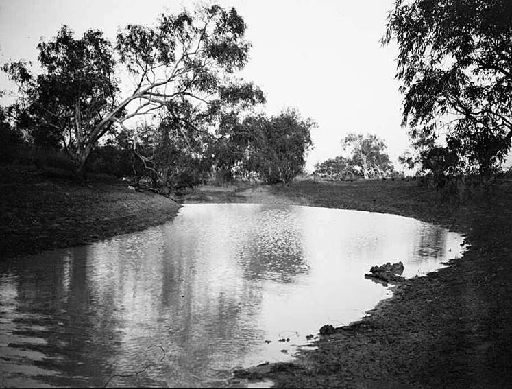
Figure 8 : Photograph by Terry in 1925 of Billiluna Pool.
Courtesy of the National Library of Australia nla.obj-149091869.
Billiluna History
Billiluna’s history is recorded in three parallel, yet interwoven streams. If they chose to do so, people of the time in the region could be listed in the Western Australian Post Office Directories and/or Electoral Rolls. While being listed in such records definitely locates an individual/entity at that time, not being listed does not necessarily mean the individual/entity was no longer there; it just means that the individual/entity was not listed at that time! The tenure of the land in the region can be traced by public records. Again, however, while such information reveals who owned the lease to the land, who actually occupied/worked the land is not always clear. Woven between the facts of individuals, entities and the land, is the anecdotal record from literature. The anecdotal record, including maps and media, especially when based on human recall, can vary enormously in its accuracy. With the above in mind the following is a history extracted from each of the three streams.
People (extracted from Western Australian Post Office Directories 1915-1949 and Electoral Rolls)
From the Western Australian Post Office Directories (State Library of Western Australia, 2016) for Halls Creek, and the relevant Electoral Rolls for the Western Australia, Legislative Assembly, Kimberley Electoral District the following, significant information listed below, was extracted. The name of the station manager was only noted where it was specifically recorded that that person was indeed the manager. Any other persons’ or entities’ name(s) associated with a station was noted under Owner(s)/Occupier(s). Other information about the year is in the Notes.
|
Year |
Lease |
Owner(s)/Occupier(s) |
Manager |
Note |
|
1915 |
Flora Valley Gordon Downs Sturts Creek |
Buchanan & Gordon Brothers Farquharson Brothers Vestey Brothers |
AB Seaton |
Media reported Ludlow J ffrench appointed Manager Sturt River (sic) in 1915 |
|
Flora Valley Gordon Downs Sturts Creek |
Vestey Brothers Farquharson Brothers Vestey Bros. |
RR MacPherson
WE Richards |
ffrench said to be Manager Sturts Creek also in 1916 |
|
|
Flora Valley Gordon Downs Sturts Creek |
Vestey Brothers Farquharson Brothers Vestey Brothers |
RR MacPherson
L ffrench |
After ffrench and before Condren, Ted Hesse said to have managed Sturts Creek |
|
|
1918 |
Flora Valley Gordon Downs Sturts Creek |
Vestey Brothers Farquharson Brothers Vestey Brothers |
RR MacPherson
J Condren |
Clarrie Wilkinson managed Sturts Creek from 1917, after Condren left for Billiluna |
|
1919 |
Flora Valley Gordon Downs Sturts Creek |
Vestey Brothers Farquharson Brothers Vestey Brothers |
RR MacPherson
J Condren |
Flinders, JF first listed as Constable in Charge, Halls Creek |
|
1920 |
Flora Valley Gordon Downs Sturts Creek |
Vestey Brothers Farquharson Brothers Vestey Brothers |
RR MacPherson JT Egan J Condren |
|
|
Flora Valley Gordon Downs Sturts Creek |
Flora Valley & Margaret Ltd Aust. Investment Agency Sturt Pastoral Co Ltd |
Richard Laffin |
Prideaux, Fred J first listed as Postmaster & Magistrate, Halls Creek |
|
|
1922 |
Flora Valley Gordon Downs Sturts Creek |
Flora Valley & Margaret Ltd Aust. Investment Agency Sturt Pastoral Co Ltd |
Richard Laffin
J Barry |
Sturts Creek still part of the Vestey Group |
|
1923 |
Flora Valley Gordon Downs Sturts Creek |
Flora Valley & Margaret Ltd Aust. Investment Agency Sturt Pastoral Co Ltd |
Richard Laffin
J Barry |
Australian Investment Agency (AIA) another name for Vestey Brothers or the Vestey Group |
|
1924 |
Flora Valley Gordon Downs Sturts Creek |
Flora Valley & Margaret Ltd Aust. Investment Agency Sturt Pastoral Co Ltd |
Richard Laffin
J Barry |
|
|
1925 |
Flora Valley Gordon Downs Sturts Creek Billiluna |
Flora Valley & Margaret Ltd Aust. Investment Agency Sturt Pastoral Co Ltd Billiluna Pastoral Co Ltd |
A Manderson J Barry F Rowan |
Terry (1927) reported Rowan as Manager Billiluna |
|
1926 |
Flora Valley Gordon Downs Sturt Creek Billiluna |
Flora Valley & Margaret Ltd Aust. Investment Agency Sturt Pastoral Co Ltd Billiluna Pastoral Co Ltd |
A Manderson J Barry F Rowan |
Terry (1927) mentions Manager Manderson |
|
1927 |
Flora Valley Gordon Downs Sturt Creek Billiluna |
Flora Valley & Margaret Ltd Aust. Investment Agency Sturt Pastoral Co Ltd Billiluna Pastoral Co Ltd |
A Manderson J Barry F Rowan |
Gordon Downs Pty. Ltd. and Sturt Creek Pastoral Co. Pty Ltd. companies in the Vestey Group |
|
1928 |
Flora Valley Gordon Downs Sturt Creek Billiluna |
Flora Valley & Margaret Ltd Aust. Investment Agency Sturt Pastoral Co Ltd Billiluna Pastoral Co Ltd |
A Manderson J Barry F Rowan |
|
|
1930 |
Sturt Creek |
Sturt Pastoral Co. Ltd |
J Barry |
|
|
1941/42 |
|
|
|
Rowan no longer listed |
|
1945-49 (last published 1949) |
|
|
|
Billiluna no longer listed |
Land Tenure (acquired through services of Landgate Western Australia, 2017)
The name(s) on the leases, covering the era from the first release of Crown Land to the late 1970s when the historical leases were amalgamated/divided to form today’s Billiluna and Lake Gregory Aboriginal Lands Trust leases, were purchased from Landgate. The lease information indicated the following course of events.
Joseph Condren obtained tenure over nearly 380,000 acres of Crown Land in July 1920. The area comprised three leases; two leases being of 20,000 acres each around today’s Billiluna (Mindibungu) and nearly 340,000 acres straddling Sturt Creek in the region of Billiluna Pool. A few months later on 8 December 1920 the lease for the 340,000 acres, previously registered on 7 July 1920, was transferred by endorsement i.e. signed over, to the Billiluna Pastoral Company Limited of No.10, Bank of New South Wales Chambers, St Georges Terrace Perth. A notice on page 3 of The West Australian newspaper of Tuesday 19 October 1920 gave this address for the Registered Office of the Billiluna Pastoral Company Limited (formerly Sturt Creek Pastoral Company, Limited) as required by The Companies Act, 1893. Please refer to Annexure D and Figures 9, 10 and 11 below.
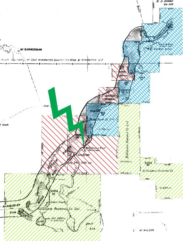
Figure 9 : Section of the circa 1920 Pastoral Map of the era, showing Billiluna Pool (highlighted by green flash), and the surrounding leases in the names of
J. Condren (red stripes), the Billiluna Pastoral Company Limited (light green stripes) and Sturt Pastoral Company Limited (blue crosshatch).
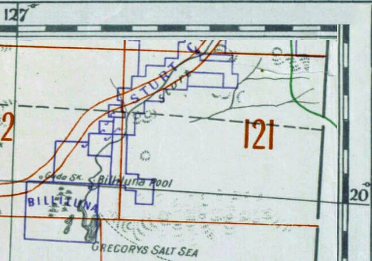
Figure 10 : Section of the 1924, Map of Western Australia showing localities of Sheep and Cattle Stations by the Department of Lands and Surveys, Western Australia, showing lease boundaries as in Figure 9. Courtesy National Library of Australia nla.obj-229849268.
showing lease boundaries from the 1924 map at Figure 10 in a modern context with
J. Condren (red stripes), the Billiluna Pastoral Company Limited (light green stripes) and Sturt Pastoral Company Limited (blue crosshatch).
On 31 January 1923 the mortgage (760/1923) was taken over from the Billiluna Pastoral Company Limited by Robert Falconer of Walter Street Claremont. The mortgage was subsequently discharged on 19 August 1926. The lease was later forfeited on 2 September 1932.
Figure 12 : Section of the 1951, Map of Western Australia showing localities of Sheep and Cattle Stations by the Department of Lands and Surveys, Western Australia.
Courtesy National Library of Australia nla.obj-234154822.
Figure 13 : Section of geoMap 250K mosaic of 1: 250,000 scale topographic maps of the region between Mindibungu and Balgo, WA,
showing the Billiluna station boundary from the 1951 map at Figure 12 in a modern context.
By the end of 1930, Robert Falconer still had his 340,000 acres taken over in 1923 from the Billiluna Pastoral Co Ltd. Extant leases comprised those of Joseph Condren (40,000 acres in 2 leases), the remaining leases of the Billiluna Pastoral Co Ltd (720,000 acres in 4 leases), and the Sturt Pastoral Co Ltd, 87,000 acres in 2 leases acquired in 1923. An advertisement on page 15 of The West Australian newspaper of Friday 27 March 1925 however, offered for sale, Billiluna Cattle Station as a going concern. The area of the station was given as 897,000 acres (please refer to Annexure D). Given subsequent information, Falconer purchased Billiluna’s leases in the late 1920s. Thus, the area for sale in 1925 was almost the equivalent to the leases then held by Condren, the Billiluna Pastoral Co Ltd, the Sturt Pastoral Co Ltd and Falconer. Also around this time Edwin Henry Eagland acquired almost 135,000 acres in 5 leases.
At the beginning of 1932, Falconer acquired a further almost 100,000 acres in two leases. By the beginning of 1934 Falconer was now registered as having acquired Condren’s 2 leases and the remaining 4 leases of the Billiluna Pastoral Co Ltd. These acquisitions would now have taken Falconer’s holdings to nearly 1.2 million acres exceeding the limit of 1 million acres per owner. This fact probably accounts for the forfeiture of the 340,000 acres, mentioned above, in September 1932 to keep under the limit. At the beginning of 1934, Falconer’s leases were consolidated into a single lease of just under 860,000 acres (i.e. the 1.2 million minus 340,000 acres or specifically 859,491 acres). Please refer to Figures 12 and 13 above.
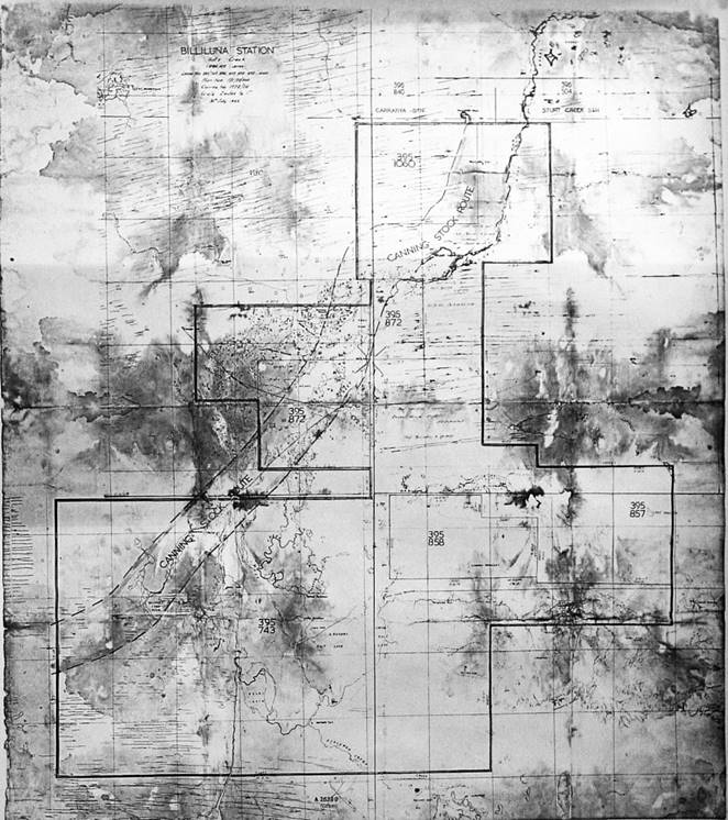
Figure 14 : Map of Billiluna Station Lease, issued at Halls Creek in 1963, after Mahood (2016).
showing Billiluna station boundary from the 1963 map at Figure 14 in a modern context.
Mary Alexandra Noske acquired two leases of some 66,000 acres in 1932. During 1936, Noske took over Eagland’s 5 leases and following some adjustment to the areal coverage of her total holdings, held tenure of nearly 170,000 acres by the end of 1936. Towards the end of the 1930s, in March 1938, the Sturt Pastoral Co Ltd forfeited its two leases totalling 87,000 acres.
Throughout the early 1940s, James Geddes Falconer acquired three leases of nearly 117,000 acres and Arthur Adrian Probert, acquired a single lease of 20,000 acres (James Geddes was the son of Robert). Then in 1965, the group of Lindsay William Paul Lovick, Alan Lindsay Lovick and Graham Stanley Canning obtained a single lease of some 30,500 acres. Please refer to Figures 14 and 15 above, showing Billiluna station boundary at 1963.
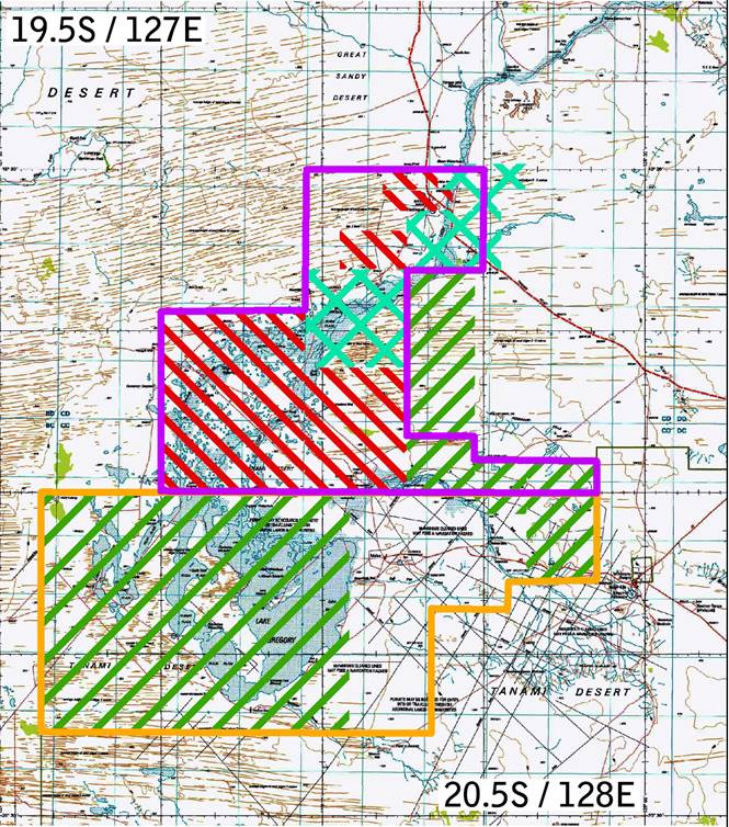
Figure 16 : Section of geoMap 250K mosaic of 1: 250,000 scale topographic maps of the region between Mindibungu and Balgo, WA,
showing lease boundaries of Billiluna (purple) and Lake Gregory (orange) stations at 1999 in a modern context,
together with extents of circa 1920 leases being J. Condren (red stripes), the Billiluna Pastoral Company Limited (light green stripes) and Sturt Pastoral Company Limited (blue crosshatch).
Graham Stanley Canning and Allan Joseph Collopy secured a single lease of nearly 600,00 acres in March 1969. Their lease comprised land previously held under seven leases by Noske, one lease by Probert and one lease by the Lovik group. Later in June 1969, Frederick Spencer acquired a single lease of just under 52,000 acres. Then at the beginning of 1976 Billiluna Pty Ltd acquired a single lease of just under 54,000 acres.
On 3 March 1977 all existing leases held by the Falconer’s, Canning and Collopy, Spencer and Billiluna Pty Ltd were acquired by the group of TA (Thomas Arthur) Doman & Co Pty Ltd, Charla Downs Pty Ltd and Wongawol Pty Ltd (all three businesses associated with the Doman family, please see Annexure F). The area of the leases involved was in excess of some 2 million acres, however the resulting area of the new leases was around 1 million acres. The area within the boundary of today’s Billiluna Station was 460,824 acres and that within the boundary of today’s Lake Gregory Station 671,622 acres. Please refer to Figures 16 above and 17 and 18 below, which shows the Billiluna and Lake Gregory stations leases.
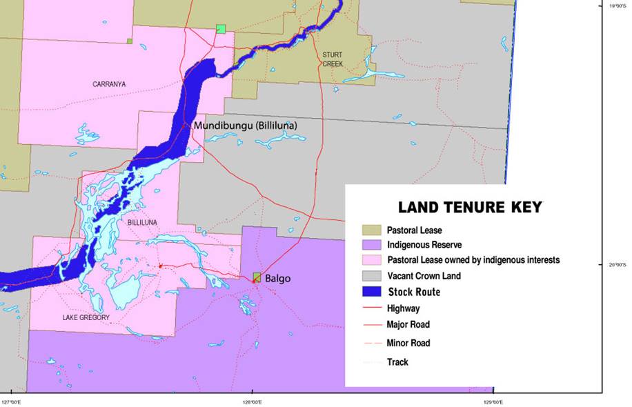
showing the Billiluna lease today and the tenure of the surrounding land.
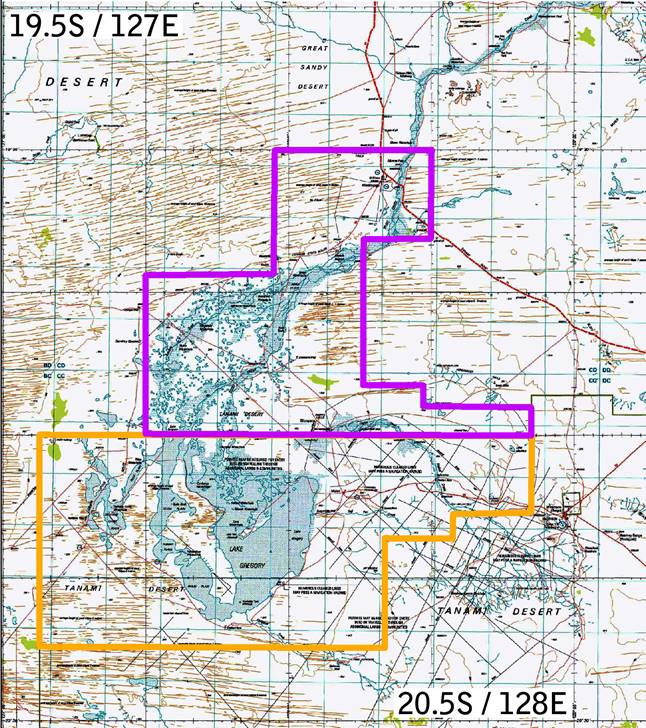
Figure 18 : Section of geoMap 250K mosaic of 1: 250,000 scale topographic maps of the region between Mindibungu and Balgo, WA,
showing lease boundaries of Billiluna (purple) and Lake Gregory (orange) stations from Figure 17 above.
Anecdotal record, including maps and media
The Post Office directory for 1918 has Joseph Andrew Condren (c1865-1922) listed as Manager Sturts Creek and by 1919 he was also on the electoral roll as Station Manager. These facts support Clement’s (2016), suggestion that Condren was Manager Sturt Creek as early as 1916-17, which he then left and went to Billiluna. By mid-1920, Condren had pastoral leases under his own name. The 1921, Map of Western Australia by Hope and Klem, surveyors and draughtsmen of Perth, please refer to Figure 7 above, shows the principal sheep and cattle stations in the region of the southern section of Sturt Creek. Clement (2016), stated that the Hope and Klem 1921 map : showed the large central component of Sturt Creek Station straddling Sturt Creek, with a smaller detached component to the east and another even smaller one to the south. Vacant Crown land separated the eastern component from the main component of the station, while one of three small parcels of land held by J Condren separated the detached southern component from the main component of the station. The land held by Condren was mostly on the south side of the southern boundary of the Kimberley, and it adjoined other parcels of land held by C D McCombe and by H S Howarth.
The Broome, Nor' - West Echo, article of 23 September 1922, found in Bohemia and McGregor (1995) stated that : looking at a map [the map available in 1922 would have been similar to the later version reproduced in Figure 9 above] the reader will see, 112 miles south of Halls Creek (136 miles by the stock route), Billiluna Pool marked, and from there, N., S., E., W., pastoral leases in the name of J. Condren and the Billiluna Pastoral Co. Condren's homestead was at Billiluna Pool. The Age of Friday 22 September 1922, on page 8 had : some months ago Mr. Condren, on behalf of the Billiluna Pastoral Company, took up a new run some distance beyond the company’s Sturt Creek property. In Figure 10 above the same boundaries as in the circa 1924 pastoral map are depicted in the 1924, Map of Western Australia showing localities of Sheep and Cattle Stations by the Department of Lands and Surveys, Western Australia.
During this era, Vesteys (please refer to Annexure C for details) under the name Australian Investment Agency, was aggregating leases which eventually covered 8,400 square miles, the largest area in the Kimberley region. This practice of aggregation was in violation of Section 113 of the then Land Act. The extent of disregard for this provision was exposed in October 1963 by Frank Joseph Scott Wise (1897–1986), then Leader of the Opposition in the Western Australian Legislative Council (formerly State Minister for Lands and Premier, and Administrator of the Northern Territory from 1951 to 1956). More detail on this aspect can be found in the Overview of the Cattle Industry and Pastoral Leasing in the Kimberley Region, WA, at Annexure E.
At that time the Sturt Creek Pastoral Company and the Sturt Pastoral Company formed part of the Vestey group. In 1920 the record showed that the Sturt Creek Pastoral Company Limited changed its name to the Billiluna Pastoral Company Limited. Into this Vestey empire came Joseph Condren in the late 1910s as Station Manager, Sturt Creek station as indicated above. Then when Condren went to work on the Billiluna lease around 1922 Jack Barry took over managing the Sturt Creek lease. After Condren and the Billiluna Pastoral Company, the land in the Billiluna region had a number of owners. Robert Falconer, owner from 1934 of Billiluna’s 859,491 acres, as detailed above, vigorously advocated for the CSR to be kept open and maintained between 1929 and 1944. By 1940 James Geddes Falconer had joined his father in the Company but in 1949 James Falconer's leases were transferred to Margaret Doman, who with her father, then took over the property.
Despite the lease history above, according to one newspaper of the day, please refer to Annexure F, the Great Southern Herald on its page 11 of Friday 3 November 1950, had that Spencer Doman was the owner of four cattle stations in the Wiluna district with a total area of 3,760,000 acres and had recently purchased another property of 1,000,000 acres. With the new purchase, Doman and family now held nearly 7,500 square miles (1 square mile is 640 acres) of country in Western Australia. Such an area was almost comparable to that of Vesteys previously mentioned.
Spencer Doman drove cattle down the CSR until 1952. After Spencer Doman died in June 1953, the Doman pastoral properties, which included Billiluna, were split equally between the surviving Doman family members. Doman cattle continued to be moved down the CSR until 1959. During late 1963, Joe Mahood acted as interim manager of Billiluna Station for a few months. In 1965, the leases covering Billiluna were divided between Margaret Doman and her sister Lorna (Mrs Bill Wilson). According to Kim Mahood (2016), Billiluna Station included Lake Gregory in 1962. Lake Gregory did not become a separate lease until 1965. The separation of Lake Gregory and Billiluna stations thus appears to have coincided with the division of the Doman properties between the sisters, Margaret and Lorna Doman. More information on the Doman family may be found in Annexure F, Connections to the Doman Family. In 1977, Arthur Young and Company took over the Billiluna tenure until it went to the Aboriginal Lands Trust in 1978.
Others uniquely associated with Billiluna’s history are John Francis Jack Barry and Francis Joseph Dick Rowan. Jack Barry first appeared on the electoral roll in March 1925. The Post Office directory for 1922 however, has Barry listed as Manager Sturts Creek. Barry is recorded as still being manager Sturts Creek at the time of Condren’s death.
Francis Joseph Dick Rowan was managing Billiluna station by October 1922. Rowan is sometimes formally referred to as Richard Rowan in the belief that Dick was the diminutive when in fact it was a preferred name. Dick Rowan was still managing Billiluna station when Michael Terry’s expedition arrived in September 1925, and the Post Office directory first lists Rowan in 1925 (more detail on Terry’s 1925 expedition is provided below). The Post Office directory does not list Rowan or Billiluna Station before 1925, and Rowan who died in 1938, as detailed below, remains listed until 1940. Between 1945 and 1949, the name Billiluna or any of the people recorded elsewhere as being associated with it, are not listed in the Post Office directories.
Another, who becomes associated with Terry’s expedition is Michael Dick Kilmartin. Kilmartin, then prospector of Gordon Downs Station, appeared on the February 1924 electoral roll. Also of interest is Matthew James Matt Savage of Wyndham, who was listed as drover on the 31 December, 1920, electoral roll.
Summary
From the above historical streams, it is clear that the history of Billiluna Station is complex. Nevertheless, Joseph Condren, John Francis Jack Barry, Francis Joseph Dick Rowan, Robert Falconer and the Doman family all played a significant role in Billiluna’s history. It should not be overlooked however, that the Australian Investment Agency (AIA), Vestey Brothers or the Vestey Group was the controlling unseen force for much of this time, manipulating its access to land, cattle and probably people, to retain its market share of the then cattle industry.
Modern mapping
The International Map Committee determined in London in 1909 that a uniform map series covering the globe would be produced at 1: 1,000,000 scale. This map series would be known as the International Map of the World (IMW). Australia produced its first IMW in 1926. The Australian IMW series was completed in 1978 but was discontinued in 1987. For many years this small scale mapping was the only reliable, systematic map coverage available for remote areas. A section of a 1: 1,000,000 IMW map mosaic is shown in Figure 19 below.
During the Second World War came the realisation that the Japanese were approaching our shores and we had no suitable maps with which to plan a defence. The 1940 Emergency Mapping Scheme was thus instigated. One of the maps prepared under this scheme was the 1943 Halls Creek sheet at 8 miles to 1 inch or about 1: 500,000 scale. Please refer to Figure 20 below. Prepared in war-time haste, not every detail could be checked and so this map contains some anomalies which are discussed later.
Post war the National Mapping Council was formed and the Commonwealth, States and Army combined to produce the R502 series of mainly uncontoured 1: 250,000 scale topographic maps. This first national coverage of 544 (1.5° longitude by 1° latitude) map sheets, was compiled from aerial photography and controlled with surveyed networks or astrofixes. The use of aerial photography meant that for the first time the relative locations of features would be accurately portrayed although correctly naming them was another issue.
In 1965, the Commonwealth government approved the acceleration of the national topographic mapping program with the object of completing mapping coverage of the country at 1: 100,000 map scale with contours shown at 20 metre vertical intervals. The National Topographic Map Series (NTMS) program involved compilation of 3,062 sheets (30' longitude by 30' latitude) at 1: 100,000 scale. However, only 1,602 of these sheets, generally covering the more populated areas, were printed as 1: 100,000 scale topographic maps. This program was finalised in 1988.
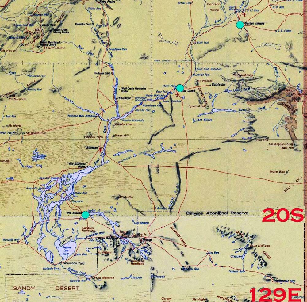
Figure 19 : Section of 1: 1,000,000 IMW map mosaic showing (light blue circles) the plotted positions of three of the astrofixes observed by Terry expedition surveyor RA Prescott, as listed in Table 1 below.
Figure 20 : 1943 topographic map sheet Halls Creek, prepared as part of the Emergency Mapping Scheme at 8 miles to 1 inch or about 1: 500,000 scale.
The enlarged insert shows the topography around the position of Billiluna.
Courtesy National Library of Australia nla.obj-233276186.
The NTMS also formed the basis for a new series of 1: 250,000 scale topographic maps that was completed around 1991. These 513 printed (1.5° longitude by 1° latitude) maps contained the generalised (for scale) features from the 1: 100,000 scale compilation material as well as contours at a vertical interval of 50 metres.
The digitised printed NTMS series has now been accessible for many years. In the area of interest, the 1: 100,000 scale information was extracted from 1: 80,000 scale monochrome aerial photography acquired in 1971. Horizontal control from the 1971 Aerodist Block Adjustment 19 was propagated to each photogrammetric model (overlapping stereoscopic aerial photopair) using the slotted template method within Photogrammetric Block 37. Vertical control for each model was provided by circa 1975 laser terrain profiles, referenced to the Australian Height Datum. Each photogrammetric model was then oriented, for scale and elevation, in a photogrammetric plotter. The model gave the operator a three dimensional view of the terrain from which the applicable features were traced onto a transparent media. For clarity, unless otherwise noted, reference to any location in this paper will be related to that shown in the geoMap 250K (Geoscience Australia, 2009) map series, as revised, as this national series is today the most readily available.
Nomenclature
In the modern era, the names appearing on maps have been approved by the relevant State Nomenclature Board or similar. Landgate in Western Australia maintains the records for all of that State’s map names and was very helpful in providing historical information on the names of features in the area of interest.
Terry Expedition, 1925
The British Spectator Magazine of 14 August 1926, carried on its pages 8 and 9 the following : Mr. Michael Terry has lately returned to England after completing yet another expedition through Northern Australia…Seven men, a dog, a wireless receiving set, a mineral prospecting outfit, survey equipment, all on two Guy Roadless trucks with trailers and an A.J.S. motor cycle with sidecar. The purpose of the undertaking was to amass data for publication in England, in order that a better and less prejudiced knowledge - of the North [of Australia] should - be awakened. The belief behind the purpose is that the Empire must do big things soon to justify continued tenancy of a land that has lain almost idle for 100 years under our flag. The map at Figure 21 below shows the route taken by Terry’s 1925 expedition with enlargement of the region around Billiluna.
As part of this expedition Terry’s party travelled down Sturt Creek to the Salt Sea (Lake Gregory). His two 1-ton model, Guy Roadless trucks carried hub-cap milometers and a table of mileages is provided in his 1927 book. The expedition’s surveyor, RA Prescott, observed a number of astrofixes for latitude and longitude. Prescott was able to get accurate time for these observations from the wireless set they carried. Terry recorded that each night or as frequently as possible, Greenwich mean time signals were received by their wireless, from Adelaide or Perth radio transmitters. These signals allowed their half-chronometer watches to be checked for their rate of variation ahead or behind Greenwich mean time. With such exact time, star observations for position would be highly accurate; of the order of several hundred metres in contrast to kilometres without access to accurate time.
A table of the locations and positions of these astronomical observations is also in Terry’s book. These observed positions can be considered close to modern GPS coordinates. The detail, distances, positions and descriptions, in Terry (1927) provided a reliable set of facts that could be traced on modern maps.
In Figure 22 below, courtesy of the National Library of Australia, is a photograph captioned : A man using surveying equipment, Northern Territory, approximately 1927. Terry (1927) contains photographs of his exploration party members of whom only RA Prescott, the party’s surveyor and radio enthusiast is wearing glasses. From the vehicles in the background of the photograph at Figure 23 and noting the man using the theodolite is wearing glasses the photograph is of RA Prescott and it is taken in 1925. Prescott wrote a brief report covering the surveying aspects of the expedition. His report can be read at Annexure G.
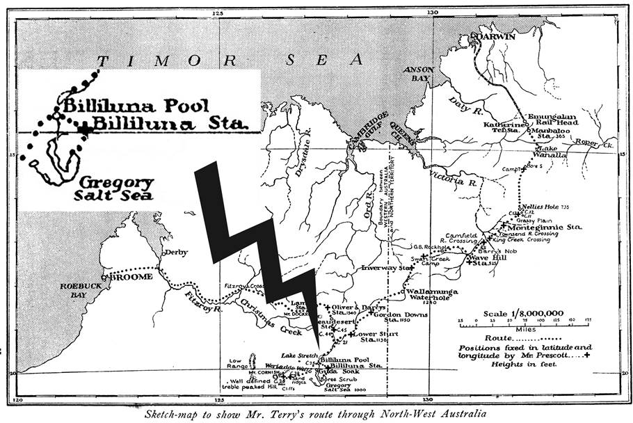
Figure 21 : Map showing the route taken by Terry’s 1925 expedition with enlargement of the region around Billiluna.
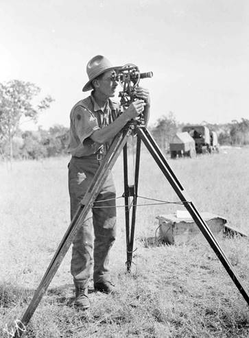
Figure 22 : Photograph, courtesy of the National Library of Australia (nla.obj-149068356),
of RA Prescott the surveyor on Terry’s 1925 expedition.
In the background are the expedition’s two 1-ton model, Guy Roadless trucks with trailers.
The positions of three astrofixes were plotted, as shown in Figure 19 above, and confirmed that they were taken at or near then Gordon Downs, Sturt Creek and Billiluna homesteads. The Billiluna fix coordinates locate it on Durbai Creek near the feature now named as Old Homestead Well. Please refer to Table 1 below, extracted from Terry (1927). A homestead called Billiluna being on Durbai Creek at the time Terry was there and later abandoned, is discussed further on in this paper.
|
Place |
S. Latitude |
E. Longitude |
||||
|
|
d |
m |
s |
d |
M |
S |
|
Gordon Downs Station |
18 |
45 |
05 |
128 |
34 |
50 |
|
Lower Sturt Station |
19 |
09 |
55 |
128 |
11 |
30 |
|
Billiluna Station |
19 |
59 |
30 |
127 |
34 |
40 |
|
Results are given to the nearest 5" of arc (approximately 150 metres). |
||||||
Table 1 : List of relevant Positions fixed by Astronomical Observations (Astrofixes) in conjunction with Wireless in Western Australia (Terry, 1927).
|
Distances between significant locations |
||
|
Location |
Kilometres |
Miles |
|
Gordon Downs Station |
0.0 |
0.0 |
|
(The) Sturt Creek |
15.8 |
|
|
Lower Sturt Station (Sturt Creek) |
66.1 |
51.2 |
|
C 21 (Canning’s tree blaze) |
48.5 |
|
|
Lake Stretch (Stretch Lagoon) |
44.8 |
|
|
Kura Soak |
19.7 |
|
|
Billiluna Pool |
6.4 |
125.0 |
|
Homestead (Billiluna at Durbai Ck.) |
17.3 |
10.8 |
|
Total |
218.6 |
135.8 |
|
Information above in parenthesis added by for clarity |
||
|
|
||
|
Homestead to edge of Salt Sea |
25.1 |
|
|
|
|
|
|
Billiluna Pool |
0.0 |
|
|
Turn-off Sturt |
6.1 |
|
|
C 25 (Canning’s tree blaze) |
17.3 |
|
|
Fresh Water Swamp (start) |
5.3 |
|
|
Fresh Water Swamp (finish) |
6.4 |
|
|
Weriaddo Well |
10.7 |
|
|
Total |
45.8 |
|
Table 2 : Extracted from Mileages on the Route by Hub-Cap Milometers (Terry, 1927) and converted to kilometres.
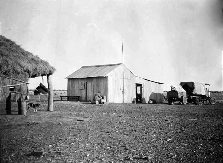
Figure 23 : Photograph, courtesy of the National Library of Australia (nla.obj-149088908),
of RA Prescott the surveyor on Terry’s 1925 expedition tuning their three valve, Gambrell & Sons wireless receiver.
One of the expedition’s two 1-ton model, Guy Roadless trucks is to the right of frame.
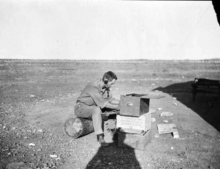
Figure 24 : Close-up photograph, courtesy of the National Library of Australia (nla.obj-149089002),
of RA Prescott the surveyor on Terry’s 1925 expedition tuning their three valve, Gambrell & Sons wireless receiver.
Note the stony ground.
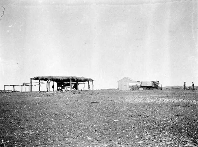
Figure 25 : Photograph, courtesy of the National Library of Australia (nla.obj-149090909),
of Terry’s two 1-ton model, Guy Roadless trucks, with their trailers, at Rowan’s Billiluna homestead shack.
Terry had arrived at Gordon Downs homestead on 18 September 1925. Here he had organised for a dump of motor spirit (benzene in red painted drums) for his vehicles. Needing a convenient fuel depot before heading into the Great Sandy Desert, Terry then arranged for Michael Dick Kilmartin to transport, using his horse dray, thirty drums of benzene. Kilmartin would : deposit them as an advance dump at Billiluna Pool, 110 miles further on our way. By this provision we could set out into the remotest interior fully supplied with petrol at the most distant point. Please refer to Table 2 above for actual mileages recorded by Terry’s party Hub-Cap Milometers.
By 24 September 1925, Terry was at Lower Sturt Creek (Sturt Creek today) homestead. He had left the slower trucks and proceeded ahead alone on the AJS motorcycle. With only the wheeltracks of Kilmartin’s team to follow he lost the trail from time to time in stony ground. Catching up with Kilmartin, above the confluence of Wolf (sic) Creek with Sturt Creek, Terry sought directions to then Billiluna homestead. Kilmartin lent him one of his group as a guide : to show you where to cross over the creek some 9 miles from here. About a mile from the place where he'll show you to cross, there should be some wagon tracks left by the teams that took the loading down to Rowan in July. Once you are set on them, just follow your nose to the homestead. You'll leave the Sturt and strike away east at the old homestead. There should be four poles standing there to mark the spot - the remains of Condren's bough-shed.
Terry was shown where to cross the Sturt so as to travel down its western side following the wheeltracks described by Kilmartin. This crossing point was around the point where Canning had blazed a tree with C 21. Continuing past Lake Stretch (today Stretch Lagoon), then Kura Soak, Terry lost the tracks but found them again just above Billiluna Pool. Here he crossed to the eastern bank of the Sturt, and found the remnants of the old homestead.
A clear track was now visible to Terry, but in avoiding the sandridges he got trapped in the soft sand, necessitating a six mile walk to the nearest habitation. Terry stated : living in a tiny shack on the crest of a stony rise was Mr. F. J. Rowan [Francis Joseph Dick Rowan], no doubt the loneliest dweller in the Commonwealth. The above description, having to negotiate sandridges, noting the distance travelled, plus the astrofix, leaves no doubt that Rowan was living at then named Billiluna homestead and his homestead shack was not far from today’s Durbai Creek. Rowan had been there a couple of months at least, as Kilmartin had taken a previous loading to Rowan in July 1925.
Figures 23, 24 and 25 above provide photographic details of Rowan’s Billiluna homestead or shack on Durbai Creek. While the photograph’s original captions were not all that informative, there is no doubt that the photographs are all of the same location and the stony ground is as described by Terry (1927). The bough shed in the photographs would be of similar construction to that Condren had built for his homestead at Billiluna Pool. Rowan, may even have occupied his bough shed while the more permanent corrugated iron homestead was being built. The Terry expedition’s 1-ton model, Guy Roadless trucks with their trailers are clearly visible in the photographs confirming the year as being 1925.
While Terry’s party is later camped beside Salt Pan Creek, whose name is unchanged today, Terry observed : Billiluna station was not taken up till 1922. Sunday, 4 October, 1925, saw Terry’s party return to Billiluna Pool to refuel : at the gaunt uprights where the old homestead had been we found the precious benzene dumped by Kilmartin, neatly stacked beneath a thick covering of spinifex to shade it from the sun. While in this region, Terry (1927) also noted that : some believe the homestead [Billiluna] lies on Sesbania Creek, whereas Rowan assured me his home was alongside Butcher Creek. Landgate’s file showed that the local name Butcher Creek was changed to Durbai Creek after Nelligan’s 1955 survey (Casey and Nelligan, 1956) and was approved in 1966.
Joseph Condren, Dick Rowan and the locations of Billiluna Homestead
As noted above, Joseph Condren was likely the Manager Sturt Creek station as early as 1916-17, which he then left and went to Billiluna. Condren’s acquired pastoral leases in his own name are duly recorded and depicted on the 1921 map by Hope and Klem. Terry (1927) then recorded that : Billiluna station was not taken up till 1922, indicating that Condren had then moved onto the lease to work it. Further, in 1922 when Condren started to work the land around Billiluna Pool the lease was now in the name of the Billiluna Pastoral Company as he had signed the lease over in late 1920. Thus Condren, when he died, having in his possession property of the Billiluna Pastoral Company is now no mystery as Condren was then working for the company.
In the 1971 book Boss Drover by Keith Willey, which is about stockman Matt Savage, Savage told Willey of a reconnaissance he undertook about 1916. When Savage and another stockman Burns worked on Sturt Creek Station they : went out to look at country and water. Savage went on to say that : a chap named Joe Condren took up the Billiluna country about 1919. He…[was] only on the property long enough to put up a bough shed for a homestead and build a store and some yards.
As outlined above, the leases in the Billiluna region were all under Vestey oversight. Thus, Condren and Barry being part of a larger organisational arrangement explains why when Condren was killed, Barry was able to quickly bring in the experienced Dick Rowan to manage the Billiluna lease.
Bianchi (2013) recorded that in 1921 Rowan took a herd down the Canning and as shown by the newspaper article at Annexure H, Rowan later took 700 Billiluna cattle down in 1931. In between these two droves, Billiluna had been put up for sale in 1925. Please refer to Annexure D to see the newspaper advertisement. Described as a deceased estate on page 15 of The West Australian of Friday 27 March 1925, the lease of nearly 900,000 acres was valid until 1948. The advertisement was by the Billiluna Pastoral Company. It would appear that this advertisement led to Falconer, mentioned above, to later take over the old Condren and associated leases, but that until his death in 1938 Rowan remained as Manager, Billiluna.
So, despite Condren being in the region for some years he was only on the Billiluna lease itself for less than nine months, and the then Billiluna homestead was only a bough shed. All the preceding is remarkably consistent with the information about Condren published in the media of the day. Billiluna Pool was indeed surrounded by leases in the name of J. Condren and the Billiluna Pastoral Company; Condren's Billiluna homestead was a bough shed at Billiluna Pool; and Condren had not been in that area very long. Also, the area was very isolated and largely unknown. Upon Condren’s untimely death, Dick Rowan was sent from Halls Creek and took over as Station Manager, Billiluna.
As noted above Prescott, the surveyor of Terry’s party, observed a number of astrofixes for latitude and longitude. The astrofix recorded as being observed at Billiluna locates it on Durbai Creek within 300 metres of the marked Old Homestead Well on the geoMap 250K, SE52-14 Billiluna map sheet. Terry (1927) noted on his arrival at this location in late September 1925 that : living in a tiny shack on the crest of a stony rise was Mr. F. J. Rowan. Thus, between Condren’s death in September 1922 and Terry’s arrival in September 1925, Billiluna homestead had been relocated from Billiluna Pool to near Durbai Creek, some 18 kilometres to the south-east.
Thus, when Terry came through in 1925, Condren’s bough shed at Billiluna Pool had been abandoned long enough to have succumbed to the elements. Four uprights were all that now remained. Kilmartin, in his directions to Terry above said : you'll leave the Sturt and strike away east at the old homestead…there should be four poles standing there to mark the spot - the remains of Condren's bough-shed. This site was also used as the forward fuel dump as Terry’s party returned to Billiluna Pool to refuel : at the gaunt uprights where the old homestead had been we found the precious benzene dumped by Kilmartin neatly stacked.
Sometime in late 1937 Rowan was thrown from his horse and in need of specialist hospitalisation was transported by the Flying Doctor to Perth in February 1938. This 2,250 mile journey was hailed as a record but for Rowan it was a painful trip. Sadly, he passed away a few weeks later and was buried in Perth on Thursday, 24 March 1938. Please refer Annexure H.
Figure 26 : Photograph of WA Lands Department surveyor, Pat Nelligan in Bianchi (2013) probably taken at then Billiluna homestead at Stretch Lagoon.
It is not clear if Billiluna homestead was relocated to Stretch Lagoon following Rowan’s death in 1938, or earlier when the lease was forfeited by Falconer in September 1932. As can be seen on the maps of the day, the Durbai Creek homestead site sat almost on the boundary of two leases; the north lease which was forfeited while the south lease was retained. In such a location Billiluna homestead could well have continued to operate as a base for the southern lease even though the land on which it sat was strictly Crown Land. In this era with little accurate surveying available, it was probably not even realised that the homestead was on forfeited land, let alone in anybody’s interests to contest the somewhat trivial issue of a few acres among so many thousands!
According to Landgate’s files Stretch Lagoon was first named by Canning in 1907 as Stretch's Lake. Renamed Stretch's Lagoon in 1910, and Lake Stretch by Terry in 1925, today’s name of Stretch Lagoon was approved after the surveys in 1955 of Patrick Francis Nelligan (Casey and Nelligan, 1956, more detail at Annexure I, photograph at Figure 26 above and map at Figure 27 below). Landgate’s files also indicated that Billiluna homestead was moved from Durbai Creek to Stretch Lagoon prior to 1943 and was still there when the 1949 aerial photography was acquired. Nelligan (Casey and Nelligan, 1956), noted in 1955 that : the homestead had again been shifted, this time to a site some 10 miles north. The Country Women’s Association (CWA), WA (undated), Kimberley Division Historical Cookery Book recorded that the Billiluna homestead at Stretch Lagoon was a mud brick building with the cook house and store built of desert oak cut from nearby trees. The then new homestead, some distance away was built about 1953.
Thus, when the 1943 map at Figure 20 above was prepared, Billiluna homestead was at Stretch Lagoon on the western side of Sturt Creek. The map however, has Billiluna homestead at about the right latitude but on the eastern side of Sturt Creek. The map is interesting in that it shows the Wiluna - Kimberley Stock Route running, as it did then, via Sturt Creek Station and Flora Valley Station.
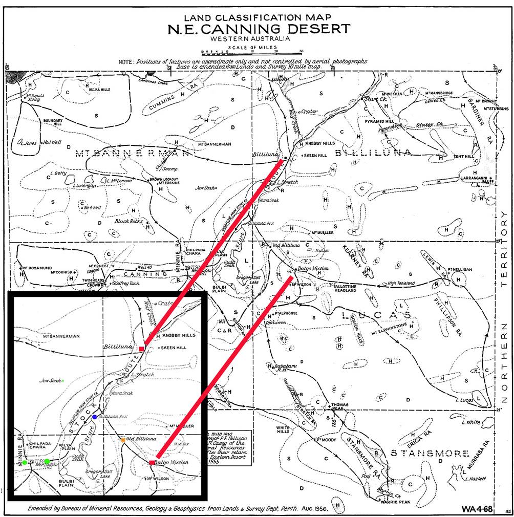
Figure 27 : Modified version of 1956 map from Casey and Nelligan (1956) showing then existence of locations known as
Billiluna (red), Billiluna Pool (blue) and Old Billiluna (orange) in relation to Balgo and CSR Wells 50 and 51 (green).
Nelligan further recorded that only ruins of Billiluna homestead remained at the Stretch Lagoon site. Later these ruins were deemed to be insignificant and approval for their deletion from maps was given on 8 November 1977. The site 10 miles north of Billiluna on Stretch Lagoon is today occupied by the aboriginal community of Mindibungu (Billiluna). Billiluna homestead being at Stretch Lagoon is only indicated on the older R502 and IMW series maps with the site named as Old Billiluna (ruins). A summary of the map series and description of Billiluna homestead at its various sites is given in Table 3 below. The locations just mentioned on the IMW and R502 maps are shown in Figure 28 below.
|
Homestead Location |
Description and Map series and scale (refer Figures 28 & 29 below) |
|
Billiluna at Billiluna Pool |
Not depicted (pre modern mapping era) |
|
Billiluna on Durbai Creek |
Old Billiluna on IMW 1: 1M scale Old Station Mill on R502 1: 250K scale Old Homestead Well on NTMS 1: 250K scale |
|
Billiluna at Stretch Lagoon |
Old Billiluna (ruins) on IMW 1: 1M scale Old Billiluna (ruins) on R502 1: 250K scale Not depicted on NTMS 1: 250K scale |
|
Mindibungu (Billiluna) |
Billiluna on IMW 1: 1M scale Billiluna on R502 1: 250K scale Mindibungu on NTMS 1: 250K scale |
Table 3 : A summary of the map series and description of Billiluna homestead at its various sites.
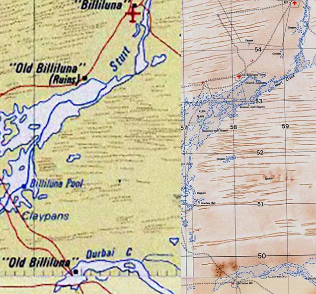
Figure 28 : Sections of IMW and R502 map sheets showing the locations of Billiluna, Old Billiluna (ruins) and Old Billiluna on IMW
and Billiluna, Old Billiluna (ruins) and Old Station Mill on R502.
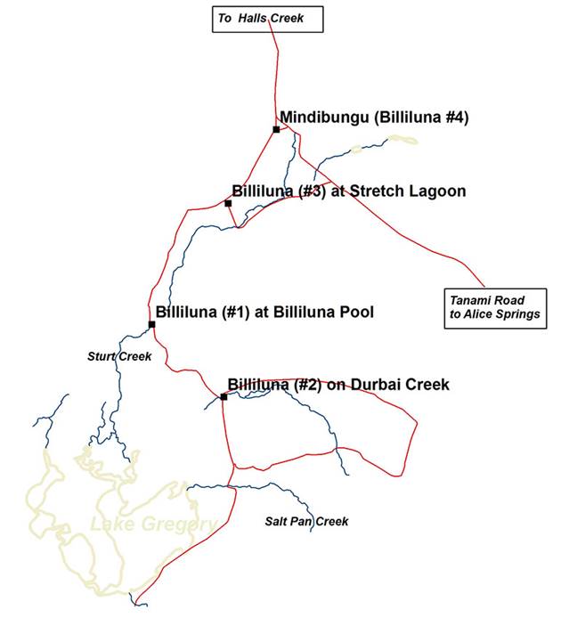
Figure 29 : Map showing the four sequential locations of Billiluna homestead.
Summary
Although approximate, the timeline for the locations, as shown in Figure 29 above, of Billiluna homestead appears to be :
|
Homestead Location |
Era |
|
Billiluna at Billiluna Pool |
early 1922 (1) – early 1923 (2) |
|
Billiluna on Durbai Creek |
early 1923 (2) – between September 1932 and March 1938 but before 1943 (3) |
|
Billiluna at Stretch Lagoon |
between 1932 and 1938 but before 1943 (3) – around 1953 (4) |
|
Mindibungu (Billiluna) |
around 1953 (4) – today (5) |
|
(1) approximate date of occupation even though land was leased from 1920. (2) following Condren’s death in September 1922. (3) the lease on which the Durbai Creek site was located was forfeited in September 1932 and Rowan died in March 1938 so the Durbai Creek site could have been abandoned around or between these dates as Landgate only has Billiluna at Stretch Lagoon prior to 1943. (4) the homestead north of Stretch Lagoon was built about 1953 according to The CWA of WA (undated), Kimberley Division Historical Cookery Book. (5) until 1978 Billiluna was a homestead before the land was sold to the Aboriginal Lands Trust and the Billiluna Community was established on this site. |
|
As Billiluna homestead has existed in different locations during its history, for any earlier reference to Billiluna homestead to be specific, its geographic location at the time eg Billiluna Pool, Durbai Creek or Stretch Lagoon needs to be included.
Acknowledgements
Customer Service, Landgate, Western Australian Land Information Authority, is acknowledged for their provision of nomenclature information, as are Geoscience Australia’s permission to reproduce the map sections under the Creative Commons Attribution 2.5 Australia Licence; and Catherine Clement for her 2016 Timeline for Sturt Creek Station and adjacent Country, at Attachment 3 in Smith (2016). Comments by Phil Bianchi on the draft and the research and assistance of Laurie McLean, were greatly appreciated.
Compiled by Paul Wise, 2016-18
Sources
Anonymous (1922), East Kimberley Outrage, The Age (Melbourne), Friday 22 September 1922, Page 8, accessed at : http://trove.nla.gov.au/newspaper/article/205770847?browse=ndp%3Abrowse%2Ftitle%2FA%2Ftitle%2F809%2F192%2F1922%2F09%2F22%2Fpage%2F18788805%2Farticle%2F205770847 and repeated in Recorder (Port Pirie), Tuesday 26 September 1922, Page 2, accessed at : http://trove.nla.gov.au/newspaper/article/102725805 .
Anonymous (1922), A North-West Tragedy, Western Mail (Perth), Thursday 28 September 1922, Page 21, accessed at : http://trove.nla.gov.au/newspaper/article/41695845?searchTerm=1922%20tragedy&searchLimits=l-state=Western+Australia|||l-title=101 .
Anonymous (1953), Death of Mr Spencer Doman, Chronicle (Adelaide), Thursday 2 July 1953, Page 9, accessed at : https://trove.nla.gov.au/newspaper/article/93940498.
Anonymous (1954), Large Estate Left Here by S.A. Man, The West Australian (Perth), Saturday 20 November 1954, Page 13, accessed at : https://trove.nla.gov.au/newspaper/article/52965918 .
Bianchi, Phil (2013), Work Completed, Canning, Hesperian Press, WA.
Bohemia, Jack and McGregor, Bill (William B) (1995), Nyibayarri: Kimberley Tracker, Aboriginal Studies Press, Canberra.
Bolton, GC (2012), Wise, Frank Joseph Scott (1897–1986), Australian Dictionary of Biography, National Centre of Biography, Australian National University, accessed at : http://adb.anu.edu.au/biography/wise-frank-joseph-scott-15616
Carnegie, David Wynford (1898), Spinifex and Sand : A Narrative of Five Years Pioneering and Exploration in Western Australia, C Arthur Pearson Limited, London, 1898; Project Gutenberg Australia e-books accessed at : http://gutenberg.net.au/explorers-journals.html .
Casey, John Newbery and Nelligan, Patrick Francis (1956), Land Classification and New Geographical Names in the North-East part of the Canning Basin, Western Australia, RECORDS 1956/106 accessed at : https://d28rz98at9flks.cloudfront.net/10082/Rec1956_106.pdf
Clement, Catherine (2016), Timeline for Sturt Creek Station and adjacent Country, Attachment 3 in Smith (2016), accessed at : https://www.flinders.edu.au/ehl/fms/archaeology_files/research/Kimberley%20Frontier/Sturt%20Creek%20-%20Final%20Report%20March%202016.pdf
Duncan, Ross (2017), Conacher, Charles William Davy (1881–1937), Australian Dictionary of Biography, National Centre of Biography, Australian National University, accessed at : http://adb.anu.edu.au/biography/conacher-charles-william-davy-5746
Edinger, Daphne Choules and Marsh, Gilbert (2004), Reassessing the Missions : Balgo – Its History and Contribution, accessed at : http://www.kimberleysociety.org/oldfiles/2004/REASSESSING%20THE%20MISSIONS%20Nov%2004.pdf
Farrands, Bruce and Jackie (2012), Personal communication (but known to be sent to many who knew, or were associated with, the Farrands over the years) dated Mid-year - July 2012.
Gregory, Augustus Charles and Gregory, Francis Thomas (1884), Journals of Australian Explorations, James C Beal, Government Printer, Brisbane, 1884; Project Gutenberg Australia e-books accessed at http://gutenberg.net.au/explorers-journals.html .
Ford, Reginald Arthur (1979), The Division of National Mapping’s Part in the Geodetic Survey of Australia, in The Australian Surveyor, June, September and December 1979: Volume 29, No 6, pp. 375-427; Volume 29, No 7, pp. 465-536; Volume 29, No 8, pp. 581-638, ISSN 00050326, published by the Institution of Surveyors, Australia.
Geoscience Australia (2006), GEODATA TOPO 250K Series 3, a vector representation of the major topographic features appearing on the 1: 250,000 scale NATMAPs for GIS, on the GDA94 coordinate system on electronic media.
Geoscience Australia (2008), NATMAP Digital Maps 2008, Map Viewer and 1: 250 000 scale topographic digital maps in ECW image format on electronic media.
Geoscience Australia (2009), geoMap 250K, 1: 250,000 scale topographic map coverage of Australia in PDF format on electronic media.
Geoscience Australia (2010), The R502 series of 1: 250,000 scale topographic maps on electronic media.
Lanagan, Eileen (Ed.) (undated), Kimberley Division Historical Cookery Book, Country Women’s Association (CWA), WA accessed at : https://infoxpert.hcshire.wa.gov.au/docs/Public/Heritage%20Information/Historic%20Shire%20Publications/Kimberley%20CWA%20Cookery%20Book%20edited%20by%20Eileen%20Lanagan/CWA%20Kimberley%20Cookery%20Book%201.pdf
Landgate (2017), Geonoma information – Land Tenure History, Personal communication, www.landgate.wa.gov.au .
Mahood, Marie (2012), Icing on the Damper, Boolarong Press, Brisbane.
Mahood, Kim (2016), Position Doubtful : Mapping Landscapes and Memories, Scribe Publications, Melbourne.
McGregor, William B (1988), Jack Bohemia and the Banjo Affair, Meridian, Vol.7, No.1, pp.34-58. (Meridian was a publication of the La Trobe University English Department and ceased in 2008).
McLean, Lawrence William (2017), Personal communications.
McLean, Lawrence William and Wise, Paul Joseph (2012), Bill Moyle’s Track for the Old Billiluna to Well 45 Section of the 1964 Halls Creek to Well 35 Geodetic Survey Traverse on the Canning Stock Route.
Smith, Pamela A (2016), Purrkuji : Massacre on Sturt Creek - Report of the History, Archaeological Survey and Forensic Investigation, accessed at : https://www.flinders.edu.au/ehl/fms/archaeology_files/research/Kimberley%20Frontier/Sturt%20Creek%20-%20Final%20Report%20March%202016.pdf
State Library of Western Australia (2017), Post Office Directories, accessed at : http://slwa.wa.gov.au/explore-discover/wa-heritage/post-office-directories/
The Canning Stock Route Project : http://www.australia.gov.au/about-australia/australian-story/canning-stock-route
Terry, Michael (1926), Through Northern Australia: Report of the Terry Australian Expedition, The Geographical Journal of the Royal Geographical Society, London, Vol.68, No.4, pp.302-325.
Terry, Michael (1927), Through a Land of Promise : with gun, car and camera in the heart of Northern Australia, Herbert Jenkins Ltd., London.
The Spectator (1926), Through Northern Australia, Spectator Archive, 14 August 1926, pp.8-9, accessed at : http://archive.spectator.co.uk/article/14th-august-1926/8/through-northern-australia
Western Australia Government (2002), Map of the Shire of Halls Creek, accessed at : https://infoxpert.hcshire.wa.gov.au/docs/Public/Maps/Shire%20of%20Halls%20Creek%20Map1.pdf )
Walsh, GP (2007), Kelly, John Henry (1895–1983), Australian Dictionary of Biography, National Centre of Biography, Australian National University, accessed at : http://adb.anu.edu.au/biography/kelly-john-henry-12721
Willey, Keith Greville (1971), Boss Drover, Rigby Books.
Augustus Charles Gregory, (1819-1905)
Augustus Charles Gregory first came to this region in 1856. On 21 February 1856 Gregory’s party crossed into Western Australia from the north-east. He recorded we have this day passed the boundary of Western Australia, which is in the 129th meridian. Latitude by Canopus and Procyon 18 degrees 26 minutes. The next day his party reaches a creek which we named after Captain Sturt. Following the creek generally south-west on the night of 23 February 1856 I took a set of lunar distances, which the cloudy weather had prevented for more than a week, though I had been able to get altitudes for latitude. Latitude by Canopus, Castor and Pollux 18 degrees 39 minutes 54 seconds.
By 1 March 1856, the party, still following the creek, the country beyond the effect of inundation changed to a nearly level plain of red sand. They camped that night at a fine pool of water three to five feet deep and twenty yards wide. Latitude by Canopus, Castor and Pollux 19 degrees 40 minutes 45 seconds. On 2 March, Mount Mueller was named after their doctor. Still following the creek south-west, on 4 March it spread into the dry bed of a salt lake more than a mile in diameter. This was connected by a broad channel with a pool of salt-water in it, with a second dry salt lake eight miles in diameter. Latitude by e Argus 20 degrees 10 minutes 40 seconds. After climbing a hill which was named Mount Wilson, after the geologist attached to the expedition, nothing was visible but one unbounded waste of sandy ridges and low rocky hillocks, which lay to the south-east of the hill. All was one impenetrable desert, as the flat and sandy surface, which could absorb the waters of the creek, was not likely to originate watercourses.
Gregory concluded on 8 March 1856, that having followed Sturt's Creek for nearly 300 miles, we have been disappointed in our hope that it would lead to some important outlet to the waters of the Australian interior; it has, however, enabled us to penetrate far into the level tract of country which may be termed the Great Australian Desert. Latitude by Pollux and e Argus 20 degrees 4 minutes 5 seconds. While Gregory did not name the salt lake, it became known as Gregory's Salt Sea but is now known as Lake Gregory. The following day Gregory’s party headed back along the Sturt.
David Wynford Carnegie, (1871-1900)
Carnegie’s party travelled from the south passing to the west of Sturt Creek to Halls Creek. On 22 March 1897, they headed south to meet Sturt Creek and follow it south. After taking the road to Flora Valley Cattle Station, they travelled south-east to Denison Downs, the most magnificent plains of grass. Reaching Sturt Creek, the party followed it to Denison Downs Homestead then the last settlement to the southward, and I should say the most out-of-the-way habitation in Australia of today. The owners were a Messrs. Stretch and Weekes whose names can be found on today’s maps of the area.
Carnegie wrote of Sturt Creek that it rises in the Northern Territory, runs for nearly three hundred miles in a south-westerly direction, and comes to an end in a large salt-lake, across the border, in the desert. On either side of the creek fine grass plains spread east and west. At the latitude of Mount Mueller, the grass plains gain the day; and a very pretty bit of country they form too, especially when the creek is running, as it was when we were there. In many places its waters had overflowed the banks, expanding into clay-pans and lagoons of beautiful clear water.
The Wolf rises on the opposite slope of the watershed to Christmas Creek and the Mary River, and floods twice or thrice a year. Below its junction with the Sturt the combined creek takes on itself the character of the Wolf, and at the point of confluence the Sturt may be said to end. Seeing how seldom the Sturt runs its entire length and how small its channel is at this point, smaller than that of the Wolf, I think that it is to the latter that the lakes (Gregory's “Salt Sea”) chiefly owe their existence. On nearing the [salt] lakes the creek assumes a dismal appearance but a curious point about this lower part of the creek is, that stretches of fresh and salt water alternate.
The creek enters the first lake in a broad estuary; this lake is some four miles long by two miles wide, lying North and South. At the southern end a narrow channel, 150 yards wide, winds its way into the large lake beyond, a fine sheet of water, eight miles in diameter. The lake has no outlet; of this Gregory satisfied himself by making a complete circuit of it. I feel confident, therefore, that no outlet exists, and that beyond doubt the Sturt ends at the Salt Sea, and does not “make” again further South, as some have suggested.
Vestey Group Limited (commonly just Vesteys)
The Vestey Group (specifically Vestey Group Ltd and formerly Vestey Brothers) is a privately owned United Kingdom (UK) group of companies. Vesteys today comprise an international food product business and significant cattle ranching and sugar cane farming interests mainly in Brazil.
William Vestey (1859-1940, later Lord Vestey) and his younger brother Edmund (1866-1953, later Sir Edmund) established the Vestey empire in 1897 from a family butchery business in Liverpool. They were a pioneer of refrigeration, opening a cold store in London in 1895.
These early activities soon developed into importing beef and beef products into the UK. In turn these activities led to them owning cattle ranches in Brazil, Venezuela and Australia and their own meat processing factories in Argentina, Uruguay, New Zealand and Australia. At their peak, Vesteys had canneries, butchershops and a shipping company (the Blue Star Line) within their control.
Around the early 1900s the Vestey family company had begun purchasing agricultural and grazing land in South America and Australia. In Australia, Vesteys, under the name Australian Investment Agency, aggregated a large number of Kimberley cattle station leases notably Flora Valley, Sturt Creek, Gordon Downs and Ruby Plains. In 1914, Vesteys expanded by building a meat processing works in Darwin. Commencing operations in 1917 the works closed in 1920.
On its Australian cattle properties, Vesteys made good use of the Australian Aboriginal people as cheap labour. The Aborigines were paid less than a quarter of the minimum wage of non-Indigenous workers and sometimes only received salt-beef, bread, tobacco, flour, sugar and tea instead of a salary. In 1966, this sparked the Gurindji strike at the Vestey-owned Wave Hill Station. As a consequence of the strike Gough Whitlam's Labour government forced Vesteys to return part of its land to the indigenous owners in 1973.
The Vestey Group had sold all their Australian cattle stations by 1992.
Charles William Davy Conacher (1881-1937) joined Vestey brothers' International Export Coy Ltd as an executive representative in China and in their Madagascar meatworks. In early 1916 he was transferred to Darwin, Northern Territory (Duncan, 2017),
In 1913 Vesteys had leased large properties, both in the Territory and the East Kimberley district of Western Australia. Soon after, in 1914, the building and operation of a meatworks near Darwin fell under Conacher’s control. When the works closed in 1920, Conacher was transferred to Sydney where he served Vesteys as manager of their Australian Investment Agency whose major interests also lay in the meat industry. His last position, from 1934, was general manager in Australia of Vesteys' fleet of passenger and refrigerated cargo ships, the Blue Star Line.
Billiluna and the Canning Stock Route (media articles)
|
THE COMPANIES ACT 1893. BILLILUNA PASTORAL COMPANY, LIMITED. Notice is hereby given that the REGISTERED OFFICE of the Billiluna Pastoral Company Limited (formerly Sturt Creek Pastoral Company, Limited) is SITUATED at No. 10 Bank of New South Wales Chambers, St. George's Terrace, Perth. Dated this 18th day of October, 1920. THOMAS WALKER, Weld Cambers, St. George's Terrace, Perth, Solicitor for the Company |
|
|
Source |
The West Australian (Perth, WA) Tue 19 Oct 1920, Page 3 |
|
Article |
THE COMPANIES ACT 1893. NOTICE OF CHANGE OF REGISTERED OFFICE. Notice is hereby given that the REGISTERED OFFICE of the BILLILUNA PASTORAL COMPANY LIMITED, is changed and is now SITUATED at 69 St. George's Terrace, Perth, and will be accessible to the public between the hours of 9 a.m. to 3 p.m. on week days' and 9 a.m. and noon on Saturdays. C. A. HENDRY, Secretary. Billiluna Pastoral Co., Ltd. |
|
Source |
The West Australian (Perth, WA) Wed 6 Jul 1921, Page 3 |
|
Article |
The above advertisement reads :
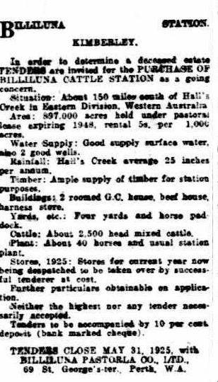
BILLILUNA STATION KIMBERLEY.
In order to determine a deceased estate, TENDERS are invited for the Purchase of Billiluna Cattle Station as a going concern. SITUATION : About 150 miles south of Hall's Creek in Eastern Division Western Australia. AREA : 897,000 acres held under pastoral lease, expiring 1948, rental 5/- per 1000 acres. WATER SUPPLY : Good supply surface water, also 2 good wells. RAINFALL : Hall’s Creek average 25 inches per annum. TIMBER : Ample supply of timber for station purposes. BUILDINGS : 2 roomed G.C. house, beef house, harness store. YARDS etc. : Four yards and horse paddock. CATTLE : About 2500 head mixed cattle. PLANT : About 40 horses, and usual station plant. STORES, 1925 : Stores for current year now being despatched to be taken over by successful tenderer at cost. Further particulars obtainable on application. Neither the highest nor any tender necessarily accepted. Tenders to be accompanied by 10 percent deposit (bank marked cheque). TENDERS CLOSE MAY 31, 1925, with BILLILUNA PASTORAL CO. LTD, 69 ST GEORGE'S TERRACE, PERTH WA |
|
Source |
The West Australian (Perth, WA) Friday 27 March 1925, Page 15 Advertising : http://trove.nla.gov.au/newspaper/article/31287285 |
|
Article |
BILLILUNA PASTORAL COMPANY. The Premier, on behalf of the Minister for Lands, told Mr. Coverley that the last lease granted to the Billiluna Pastoral Co., on January 14 1924 was for 71,680 acres. This was held under conditions applying to pastoral leases as prescribed in the Land Act, 1898, and the rent had been fixed at 5s. per thousand acres per annum. The lease was subject to re-appraisement in 15 years’ time. |
|
Source |
The West Australian (Perth, WA) Wed 12 Aug 1925, Page 9 |
|
Article |
MOTORING ACROSS THE BIG SPACES (relevant section only) The Canning stock route from Wiluna, terminating at Hall's Creek, a distance of more than 800 miles, was reconditioned last year by the septuagenarian surveyor, Mr. Canning, who originally blazed the trail many years ago. Only two mobs of cattle had, previous to last year, traversed this route. One party was annihilated by the natives, and the whole of their cattle lost. Last year two mobs of 500 head went from Billiluna Pool, and arrived safely at Wiluna in, I understand, very satisfactory condition due to a very favourable season. This is probably the loneliest route in the world. There are something like 30 shallow wells on it, and the cattle are entirely dependent upon the water from these, as there are no natural catchments. |
|
Source |
Chronicle (Adelaide, SA) Thu 14 Jan 1932, Page 6 |
|
Article |
FIRST CATTLE SALE AT WILUNA STOCK FROM BILLILUNA STATION. Wiluna, Sept. 19. The first cattle sale was held at the Wiluna stock yards yesterday. The stock was brought overland from Billiluna station and the attendance of buyers was fair. Two hundred, and fifty bullocks in first class condition were sold to the Taoinoola Pastoral Company for 95/- a head after brisk bidding. One hundred cattle in good condition, but plainer and smaller, were passed in at 60/-. Thirty-seven cows in fair condition were unsold. Owing to the dry season causing lack of feed, no further mobs will travel down the stock route this season. The facilities provided at the yards by the Wiluna Roads Board were favourably commented upon by the agents, Elder, Smith, and the buyers. It is anticipated that the balance will be sold privately. |
|
Source |
Kalgoorlie Miner (WA) Fri 20 Sep 1935, Page 7 |
|
Article |
Commonwealth Gazette No.33 of 2 April 1936, the Billiluna Pastoral Company Limited, Billiluna, Halls Creek, was only one of hundreds of Pastoralists listed in the industrial dispute between The Graziers Association of New South Wales and Others, Claimants, V. The Australian Workers Union. The matter was listed for the Commonwealth Court of Conciliation and Arbitration, Melbourne, on 19 March 1938. |
|
Source |
|
Article |
Western Australia Government Gazette, No.23 of 13 March 1964, Stock Brands Directory of Western Australia to 31 December 1962, listed Billiluna Station as having registered brand UD7. |
|
Source |
Overview of the Cattle Industry and Pastoral Leasing in the Kimberley Region, WA
(The majority of the following came from a 1971 report Beef in Northern Australia, by John Henry Kelly (https://openresearch-repository.anu.edu.au/bitstream/1885/115053/2/b13680018.pdf))
Over most of its history the beef industry of the remote regions of northern Australia was operated on a near primitive open range system of grazing on cattle stations, which varied in size from a few hundred to about 10,000 square miles, carrying herds of from less than 1,000 to more than 100,000 cattle. At the turn of the 20th century, beef cattle numbers in northern Australia totalled 4.2 million. The nineteenth century peak of 7 million cattle was reached in 1894. At the end of the 1899-1903 drought, cattle numbers had fallen to 2.5 million and did not recover to 7 million until 1920. Over the period 1963-9 there was no significant change in cattle numbers of around 700,000.
With rare exceptions, beef cattle raising in northern Australia was not a profitable enterprise over the first half of the 20th century. Beef prices in the domestic market were almost uniformly low, production being mostly surplus to Australian demand. From the 1890s onwards northern cattlemen became increasingly dependent upon export outlets for their marketable cattle. Market outlets for remote region cattle were restricted and cattle prices were low until the early 1950s. Consequently, structural improvements on many holdings were inadequate for establishing effective control of cattle and reasonable animal husbandry. This open range system of grazing, operated in the Kimberleys until 1970.
Cattle were largely of nondescript quality. Without control, cattle numbers increased during runs of good seasons beyond limits of safety, with inevitable over-concentration around remaining natural surface waters in adverse seasons, leading to over-grazing and consequent denudation of native pasture and serious soil erosion. In many parts the cattle-carrying capacity of the native pastures and edible bush was substantially lower in the 1960s than when cattle raising was established in remote Queensland regions in the 1850s, in the Northern Territory in the 1870s, and in the Kimberleys in the 1880s.
At the beginning of settlement, in the 1880s, the Kimberley pioneers had held great expectations of a thriving pastoral industry which, however, did not materialise. At the turn of the 19th century, Kimberley cattle numbers totalled 205,000 head, rising to a peak of 668,000 in 1917 when markets were restricted and cattle turn-off was low. By 1948 however, cattle numbers had declined to 430,000.
The government of Western Australia built a meatworks at Wyndham where slaughtering and refrigeration began in 1919. Except for a brief cessation in the beef slump year of 1921, and the war years 1942-4, when East Kimberley cattle were walked to Katherine, in the Northern Territory, for slaughter to provide beef for the armed forces, the meatworks at Wyndham operated continuously. The Wyndham meatworks operated under government ownership to 1966, when the works were sold to a private enterprise.
Earlier, the Australian Investment Agency otherwise known as Vesteys Ltd. acquired Wave Hill Station of about 6,000 square miles in 1914. This acquisition and others, expanded their landholdings in the Northern Territory to 27,670 square miles by 1916. Together with large estates in East Kimberley, totalling 8,400 square miles which, with subsequent acquisitions in Queensland, made them the biggest landholders in Australia. By acquisition and extension, in New South Wales, Victoria, and Queensland, Vestey also became the biggest meatworks’ operators in Australia. In 1914 Vestey signed an agreement for the establishment of a meat-works at Darwin. Construction of the meatworks commenced in 1914 and slaughtering operations began in 1917. Due to a range of circumstances the meatworks at Darwin operated for only four years.
Prior to 1919 the principal outlet for East Kimberley cattle was by shipment to Fremantle, for the Perth domestic market; to South-east Asian destinations and to Africa; and overland by stock route across the Northern Territory to Queensland and, in some cases, to New South Wales. In 1942 a small meatworks was established by a private company, supported by the Western Australian government, at Broome, the coastal shipment of cattle becoming difficult under wartime conditions. In 1949, a privately owned inland abattoir was established at Mt House-Glenroy Station in West Kimberley - Airbeef Pty Ltd - the slaughtered carcasses being chilled at the abattoir and then flown to Wyndham meatworks, and later to a subsidiary plant in Derby, for freezing and export.
Exports of cattle from the Port of Wyndham for the ten year period 1930-1939 in the 1940 report of the Royal Commission of Western Australia into the Financial and Economic Position of the Pastoral Industry in the Leasehold Areas in Western Australia, were detailed in a table at its Appendix 3 (http://www.parliament.wa.gov.au/intranet/libpages.nsf/WebFiles/Royal+Commission+appointed+to+inquire+into+and+report+upon+the+finaicial+and+economic+position+1940/$FILE/Pastoral+industry+1.pdf). In 1930 some 1800 cattle were exported, yet for the next nine years the yearly average was barely ten. It can be inferred that this lack of cattle exports by ship was due to the success of droving Kimberley cattle down the Canning Stock Route to the southern markets. In good seasons the cattle actually gained in condition during the journey.
The quality of Billiluna cattle, especially being pleuropneumonia and tick free, meant they could be transported anywhere in Australia. These facts are supported by an article from page 31 of The West Australian of Friday 20 August 1937 (http://trove.nla.gov.au/newspaper/article/41422244?searchTerm=billiluna%20pastoral%20company&searchLimits=). Essentially the article stated :
Elder, Smith and Co., Limited, have received instructions from the Billiluna Pastoral Co. Ltd., to offer by auction on Wednesday September 1 at10:00am, at the Wiluna Trucking Yards, 400 Forward Store Bullocks, the majority 4 and 5 years old, good condition, good colours.
These cattle are being overlanded from Billiluna Station, via the Canning Stock Route, and are described as a first-class lot forward store bullocks, specially selected, and they will be carefully drafted and sold in lots to suit purchasers.
The Billiluna bullocks overlanded in past years have always done particularly well in fattening areas, and this should be an excellent opportunity for graziers to secure good bullocks for fattening purposes.
Billiluna Station is free of tick and pleuropneumonia, and has never been subject to any quarantine conditions. The bullocks are free to be transported to any portion of Western Australia without restriction.
Arrangements will be made for the Western Australian Government Railways to provide an adequate supply of truck to ensure early dispatch of cattle purchased from this sale.
Train arrangements : buyers can leave Perth by express at 8 p.m. on Sunday, August 29, and return from Wiluna by train leaving there on September 1.
Even so there were problems. In 1962 Marie Mahood of Mongrel Downs station wrote in her 1995 book, Icing on the Damper, that : The pleuro- and tick-free stations of the southern part of the Kimberleys were grossly overstocked, unable to market their cattle to Wyndham or Derby which both had a hinterland of infected country. They were also unable to send them on the six months long walk south via the Canning Stock Route, where many of the spaced wells had caved in because the timbering had been removed by nomadic bands of Aborigines and water supplies could not be relied upon.
A large proportion of Kimberley cattle country was held in large single leases or aggregations by overseas and Australian absentee pastoral companies. There was neither freehold nor perpetual leasehold, leases being for a fifty-year term due to expire in 1983 (actually the original 1948 expiry date for leases had first been extended to 1965 and then to 2015 with a new 50 year lease regime to 2064 then being introduced). Individual cattle holdings varied in size from 150 to 1,600 square miles, the bulk being in the 750-1,500 square mile range. The Vestey-controlled East Kimberley aggregation of 8,400 square miles, mentioned above, was the largest in the Kimberley region. Herd sizes on individual stations varied between 1,600 and 50,000 head. The largest aggregation of cattle in East Kimberley was of approximately 90,000 head and in West Kimberley of approximately 59,000 head.
The history of public estate administration in the Kimberleys has been one of continued neglect resulting in serious and possibly lasting pasture denudation and soil erosion in the valleys of the Ord and Fitzroy rivers. Administrative ineptitude has been evident in persistent disregard for that part of the Western Australia Land Act which provided that the maximum area of pastoral leasehold held by one or more persons or association of persons shall not exceed one million acres.
The extent of disregard for this provision was exposed in October 1963 by Mr FS Wise, then Leader of the Opposition in the Western Australian Legislative Council (formerly State Minister for Lands and Premier, and Administrator of the Northern Territory from 1951 to 1956). This was during the debate on the second reading of a Land Act Amendment Bill, under which pastoral leases due for expiry in 1982 were extended by a new fifty-year lease from 1965 to 2015.
In the debate on the second reading, Mr Wise drew attention to the extent to which the particular provision of the Land Act, limiting the area that could legally be held by any person or interest to a maximum of 1 million acres, was being flouted :
I am brought to the point of what section 113 of the Land Act provides. It reads -
The maximum area held under pastoral lease by one person, or by two or more persons jointly, or by any association of persons incorporated or unincorporated, shall not exceed one million acres; and the Government may, in specified districts or localities, fix the maximum area to be held as aforesaid at less than one million acres.
Those words, originally intended and read as being very explicit on the point, have as years have passed been amended and modified to suit the holdings of company interests. Surely they were never meant to be a shield for a number of associated companies - really one company in some cases, and one ownership under many different names - to operate under. Some of the shareholders are not even known to the Lands Department. Further, the penal clauses of the Act in all those cases have never been operative.
Indeed, judging by the answers given by the Minister…in regard to the holding companies, it is obvious that section 113 of the Land Act has not only been violently flouted, but flagrantly and wilfully misused, without the Lands Department having any knowledge of where the shareholders are or whether their limitations conform with the requirements of the Act.
Let me refer to some of these interests. I refer to properties in the Kimberleys, some of which are in excess of 900,000 acres. They include Turner Grazing Pty. Ltd.; Ord River Ltd.; Flora Valley and Margaret Ltd.; Gordon Downs Ltd.: Sturt Creek and Sturt Pastoral Coy Ltd., and Nicholson Grazing Pty. Ltd.: All of those, plus many more in the Northern Territory, come under the wing, protection and control of the company known as Australian Investment Agency otherwise known as Vesteys Ltd. [Vestey Group Ltd].…
If there were a loophole which allowed the intention of section 113 to be legally flouted, the proper time to have closed such a loophole was when the Act was amended in 1963, when the flouting of the provision was revealed by one of such undoubted standing in the matter as Mr Wise.
As to the Western Australian government's trusteeship of the public estate in the Kimberleys, an unpalatable fact, in the context of planning for the future, must be faced: that upwards of 70 per cent of the cattle potential and the best of the pastoral country is controlled by absentee interests, predominantly of overseas origin. A heavy price has already been paid by the taxpayers of Western Australia (with more to come) in the measures now in operation for reclaiming the devastation of soil and pastures in the Ord River valley over the past fifty years. To say the least, this devastation, and the flouting of the acreage limitation imposed by section 113 of the Land Act, had been condoned for far too long.
In terms of cattle numbers, little progress has been made in the Kimberleys since numbers passed the half-million mark (512,000) in 1910. The five-year average to 1919 was 615,000; the five-year average to 1969 was 550,000. It is estimated that the combined native and improved pasture cattle potential (excluding Ord River and other large-scale irrigated pasture) of the Kimberleys is 1.2 million head. This potential will not be achieved under the existing system of land occupancy and utilisation. The history of events in the administration of the public estate in the Kimberleys over the past twenty-five years makes a mockery of the progressive northern development programs formulated by the North Australia Development Committee, approved by Mr Wise as Premier of Western Australia but denied by his successors. As pointed out in a more recent 2012 paper Investors and Kimberley Cattle, by DWG Treloar (Australian Journal of Agricultural Economics, Vol.9, No.1, http://onlinelibrary.wiley.com/doi/10.1111/j.1467-8489.1965.tb00329.x/pdf) enforcement of section 113 and thus decreasing the size of aggregated leaseholds might well inhibit long-term investment in the industry.
Nevertheless, on 1 July 2015, the Government of Western Australia, Department of Lands, announced (http://www.lands.wa.gov.au/Leases/Pastoral-Lease-Renewals/Pages/default.aspx) that of the 507 pastoral leases across 437 pastoral stations, 435 stations had had their leases renewed. Leases not renewed became unallocated Crown Land, administered by the Department of Lands. Renewal was premised on adherence to the land regulations, environmental and improvement conditions. Of the 93 Kimberley stations the average size was now some 230,000 hectares with the maximum size being 481,000 hectares. The new maximum limit per individual is now 500,000 hectares or some 1.23 million acres.
The renewal of pastoral leases in 2015 marked an historic event that will likely never happen again. It was the only time in Western Australian history that every pastoral lease had expired on the same date, and it was the only time in Western Australian history that every eligible pastoral lease that met the renewal conditions was renewed on the same date. Lease renewal now gives pastoral lessees security and certainty with new leases providing tenure for up to 50 years. Lease renewal also allows pastoralists to continue to focus on their pastoral business and contribute to the economic and social fabric of Western Australia.
Some Connections to the Doman Family
Tom Arthur Doman
Tom Arthur Doman was born in 1857 at Basingstoke, Hampshire about 45 miles south west of London. He was the seventh son of George Doman and his wife.
Tom Doman came to South Australia in about 1884. Initially he joined the South Australian Preserving Company at the inner Adelaide suburb of Kent Town. Doman subsequently went into partnership with Robert McEwin and developed a large preserving business at East Adelaide. A company, RW McEwin & Co Jam Factory, was formed about 1910 with Doman as the managing director. In 1920 the company amalgamated with Henry Jones & Co Ltd and Doman retained the position of South Australian managing director. (In 1903 Henry Jones had formed IXL as a limited liability company. The IXL brand came from Henry Jones’ personal motto: I excel in everything I do.)
In Adelaide on 18 May 1886, Tom Doman married Sarah Alice Durrant, only daughter of the late Augustine Durrant and his wife of Godalming, Surrey.
In the 1890s Doman became the owner of Yadlamalka Station a sheep and cattle property on the southern end of Lake Torrens about 35 miles north of Port Augusta. This property is still held by the Doman family who recently acquired the historic Beltana Station once owned by Sir Thomas Elder. TA Doman also owned the adjoining Kallioota Station.
In his final years Tom Doman was in failing health and about 11 months before his death, he converted his interests into the company TA Doman & Co Ltd. TA Doman died at his home at 7 Winchester Street St Peters (Adelaide) on Saturday 7 May 1921, he was in his 64th year. Tom Doman was survived by his widow Sarah Alice Doman and by their children Herbert James (born 1887), Edith, Grace, Spencer Arthur, Mabel, Leonard and Florence.
TA Doman’s estate was left to the benefit of his widow and family.
Sarah Alice Doman died at the family home in Winchester Street on 11 September 1946; she was 87 years of age.
Spencer Arthur Doman
Spencer Arthur Doman was the fourth child and second son of Tom Arthur Doman and his wife Sarah Alice Doman. On 30 October 1915 Spencer Doman married Freda MacGregor Howe, second daughter of Mr and Mrs Howe of Toorak. The wedding was at the Chalmers Church in Adelaide’s North Terrace and was officiated by the Rev T Maguire. Afterwards Spencer and Freda lived on the corner of Lambert Road and Fifth Avenue in Joslin.
Spencer and Freda Doman had four children: son Fred and daughters Margaret Christie (born September 1916), Helen MacGregor (Mrs John Bolivar Snell), and Lorna Durrant (Mrs William Alec Wilson).
As well as continuing with his father’s company TA Doman & Co Ltd, Spencer Doman developed other business interests including egg exports. Here, however, in the mid-1930s he lost two cases in the High Court of Australia; one case involved an egg handling patent against Egg-Fillers and Containers (Australia) Proprietary Limited and the other was on dissolving of a partnership with John Charles Earle.
In South Australia, Spencer Doman established a horse stud at Salisbury and was a leading breeder of thoroughbred horses and was a prominent racehorse owner.
In Western Australia, Doman was a well-known Aberdeen Angus cattle breeder who took up interests at Waroona south of Perth circa 1941 and brought into production large areas of virgin land.
In 1948 Spencer Doman bought Billiluna Station (in his daughter Margaret Doman’s name) and the Doman family used the Canning Stock Route to drove cattle south until 1959.
In 1977 Billiluna was sold to Arthur Young and Co who sold it the following year to the Aboriginal Lands Trust and the Billiluna Community was established (in 1978).
By November 1950 Spencer Doman was the owner of four cattle stations in the Wiluna district with a total area of 3,760,000 acres and had recently purchased another property of 1,000,000 acres. With the new purchase, Doman held nearly 7,500 square miles of country in Western Australia.
Circa 1951, Spencer Doman purchased Millbillillie Station that surrounded the township of Wiluna and was previously part of Lake Violet Station. The new purchase was to provide a railhead depot for cattle from Billiluna Station which was then the only Kimberley station still using the Canning Stock Route. To reduce feed costs, Doman took over the irrigated land formerly used by Plaistowe and Co Ltd as a peanut farm. On the property wells were improved and lucerne was planted out to fed working horses, stud cattle and stallions. To protect the crop from kangaroos and emus a high wire netting fence was placed around the plot. Kangaroos wore a 6-inch deep pad around the fence. Doman planned to clear land near this irrigated farm and plant wheat during the winter months.
The coronation of Queen Elizabeth II took place at Westminster Abbey on 2 June 1953. Spencer and Freda Doman visited England for the Coronation celebrations. Afterwards they travelled to Europe. Tragically on 22 June 1953 Spence Doman succumbed to injuries received in a car accident at Liège in Belgium; about 55 miles east of Brussels. Afterwards Spencer’s remains were interred at St Mary’s County Church in the village of Slaugham Sussex, about 30 miles south of London. (St Mary’s is also the resting place of Lord Nelson’s sister.) Spencer Doman died at age 62 years.
At the time of his death, Spencer Doman had extensive property interests in three Australian States. In Western Australia he was managing director of the Wongawol, Windidda, Yelma and Carnegie Stations east of Wiluna and Billiluna Station about 100 miles south of Halls Creek in the East Kimberley. He also had interests in Oakford and Charla Downs Stations at Waroona which jointly controlled about 25,000 acres in the Peel region about 60 miles south of Perth.
In South Australia, Doman owned a residential property in Adelaide, a racing stud at Salisbury; controlled the National Cannery, a prominent Adelaide meat export company; and was managing director of Yadlamalka sheep station.
In New South Wales, Doman was managing director of Riverina Estates Ltd which controlled Brookong Station on the south western outskirts of Lockhart about 60 miles north of Albury.
The estate of Spencer Arthur Doman in Western Australia was valued at £78,284/19/10. For probate purposes he was listed as a company director and pastoralist of Wilsden Street North Walkerville, South Australia. Spencer’s widow, Freda McGregor Doman and members of his family were the beneficiaries under his will in the same proportions as their interests in Charla Downs Pty Ltd.
Bill and Lorna Wilson
On 9 September 1948, the engagement was announced of Lorna Durrant third daughter of Spencer and Freda Doman of Red Court, Wilsden Street North Walkerville to William Alec (Bill) elder son of Mr and Mrs Alec Wilson of Wertaloona Station (Copley). Bill and Lorna were married at the Presbyterian Church in St Peters (Adelaide) on Friday 29 April 1949. Bill’s family then lived on Werocata at Balaklava about 50 miles north of Adelaide. The wedding reception was held at the home of the bride’s parents.
Of some 990 square miles, Wertaloona Station was on the western and southern edges of Lake Frome about 60 miles south east of Copley. Today it is part of the Rowe family’s Princess Royal Station.
Werocata was a property of about 16,000 acres that started at Balaklava and followed the Wakefield River six miles north west to the settlement of Whitwarta. Bill Wilson held the property at least into the 1960s.
Billiluna cattle were pleuro pneumonia and tick free and could be transported anywhere in Australia. However, Kimberley country to the north of Billiluna was not in that situation so Billiluna cattle could not be shipped from the Kimberley ports of Wyndham, Derby or Broome. Until the last drove in 1959, Billiluna cattle were overlanded down the Canning Stock Route. But by then due to some wells collapsing the watering points on that route of around 1,000 miles were no longer reliable.
By the early 1960s without an outlet for its cattle, Billiluna was overstocked. By then the property was being managed by Spencer Doman’s youngest daughter Lorna and her husband Bill Wilson.
In early 1962, Bill Wilson with two other Central Australian graziers Milton Edward Forbes (Milton) Willick (1912-1984) and William Johnson (Bill) Waudby (1920-1997) together with Alice Springs Stock Inspector Joe Mahood and some others sought to find an overland route to get cattle from Billiluna across the Tanami to Alice Springs through Balgo Mission.
After a suitable route was found, Bill Wilson arranged to sink several bores to establish watering points and to mark a track for cattle to follow. The Wilsons and the Mahoods together with Milton Willick and Bill Waudby decided to form a partnership to obtain a lease over and develop some excellent land they had recognised during the search for the stock route.
This land became Mongrel Downs Station in the Tanami Desert and was about 300 miles north west of Alice Springs. It extended west to the Northern Territory-Western Australia Border. Rather than just desert country, the 1, 620 square mile pastoral lease included Mitchell and Flinders grass plains, belts of mulga and fresh water lakes.
After about the first year, Milton Willick and Bill Waudby sold their interests in Mongrel Downs for nominal sums as their own property interests required the focus of their attention.
Between late 1963 and November 1971 Bill and Lorna Wilson helped Joe and Marie Mahood and their young family develop Mongrel Downs. During 1964-1971, Mongrel Downs was established from scratch. Station roads were formed, water bores put down, cattle yards constructed, and a homestead was established.
At the end of 1971, the partnership between the Wilsons and the Mahoods was dissolved and after a financial settlement the Mahood family moved to Central Queensland where they established Cattle Camp Station at Nebo. (Joe Mahood died in a helicopter crash when mustering cattle at Nebo in 1990. Marie Mahood died in 2009 at age 82 years.)
The Wilsons continued to run Mongrel Downs. Well known Territorians Fred and Pam Colson managed it for about 5 years. The property was later named Tanami Downs and was purchased for the traditional landowners with Aboriginal Development Commission funds in early 1989.
Stockman Bruce Farrands came to Mongrel Downs in late 1966 after working on Billiluna for a couple of years. In Perth in January 1968 Bruce married Jackie who had come to Mongrel Downs as a governess the previous year. (Jackie had arrived in Melbourne from France in 1965 at age 24 years. She came from Berardengo, Colombes on the Seine to the north west of Paris.)
From May 1968 Bruce and Jackie attempted to establish a tourist facility for Ansett Pioneer coaches at Tanami Bore but it was a very wet winter, tracks were impassable for many weeks and with no coaches the venture failed. In June 1969, with financial support from Bill and Lorna Wilson, the Farrands established the Rabbit Flat roadhouse on the Tanami Track about 350 miles north west of Alice Springs. The Farrands developed and operated their roadhouse until December 2012.
In 1969 Bill Wilson bought Chilla Well Station of about 1,000 square miles that partly straddled the Tanami Track about 240 miles north west of Alice Springs. This purchase was to help secure the stock route to Alice Springs for Billiluna cattle.
As with many cattle ventures, the Wilsons suffered financially from the down turn in the beef industry from the mid 1970s.
Newspaper sources used in the above :
Marriage: Spencer A Doman-Howe, 1915
https://trove.nla.gov.au/newspaper/article/8665140
Birth: Margaret Christie Doman, 1916
https://trove.nla.gov.au/newspaper/article/87526583
Birth: Daughter to Mr & Mrs Leonard Doman, 1920
https://trove.nla.gov.au/newspaper/article/57921986
Death: Tom Arthur Doman at age 64, 1921
https://trove.nla.gov.au/newspaper/article/63416571
https://trove.nla.gov.au/newspaper/article/87562937
Death: Sarah Alice Doman, 1946
https://trove.nla.gov.au/newspaper/article/130853298
Billiluna: owned by R Falconer of Bolgart and Wiluna, 1947
https://trove.nla.gov.au/newspaper/article/75087540
Engagement: Durrant-Wilson,1948
https://trove.nla.gov.au/newspaper/article/43782397
Marriage: Wilson-Doman, 1949
https://trove.nla.gov.au/newspaper/article/207127467
Property Interests: Spencer Doman, 1950
https://trove.nla.gov.au/newspaper/article/147407313
Doman’s lucerne farm at Wiluna, 1953
https://trove.nla.gov.au/newspaper/article/49080172
Death: Spencer Doman, 1953
https://trove.nla.gov.au/newspaper/article/93940498
https://trove.nla.gov.au/newspaper/article/49220460
https://trove.nla.gov.au/newspaper/article/48263748
The death of Michael Joseph Dick Kilmartin, aged 72 years, is also here:
https://trove.nla.gov.au/newspaper/article/48272757
Interred: Spencer Doman, in Sussex, UK, 1953
https://trove.nla.gov.au/newspaper/article/49219177
Property Interests etc: Spencer Doman, 1953
https://trove.nla.gov.au/newspaper/article/49216546
https://trove.nla.gov.au/newspaper/article/116886705
https://trove.nla.gov.au/newspaper/article/100664541
Estate: Spencer Doman, 1954
https://trove.nla.gov.au/newspaper/article/52965918
Balgo on Billiluna land, 1963
https://trove.nla.gov.au/newspaper/article/131724691
RECORD OF POSITIONS FIXED BY ASTRONOMICAL OBSERVATIONS IN CONJUNCTION WITH WIRELESS AND OF HEIGHTS ABOVE SEA-LEVEL
R. A. Prescott
It would be difficult to imagine better conditions for astronomical work than those which exist in the Northern Territory and Western Australia during the winter and early spring. The nights are beautifully clear and very small stars can be picked out with the telescope, while there are no insects to distract the observer.
The instruments which the Royal Geographical Society kindly lent to us were as follows : one 6-inch theodolite with micrometers in two cases; one prismatic compass; one aneroid barometer reading up to 10,000 feet; one boiling-point apparatus; one 6-inch sextant and artificial horizon; two half-chronometer watches.
The wireless receiver we had was a three-valve set, with one stage of high frequency, one detector, and one stage of low frequency amplification. It was made by Messrs. Gambrell & Sons, 76, Victoria Street, who arranged it most compactly with spare batteries, in a shut-up box with no external parts to be injured.
I used rubber-insulated wire for an aerial rigged between two trees, by cords slung over branches. The earth consisted of 20 feet of ordinary wire netting, with wire soldered to it, spread out on the ground with sticks and stones thrown on to keep it flat. The receiver was a great success, and I picked up the time signals on most nights from Perth and Adelaide at distances up to 1800 miles, but nothing could be heard in the daytime.
Dry batteries were used throughout - two Hellesen 1½ cells for the low-tension supply, and the spares were never used. Since I got back to England I have had well over one hundred hours of work from these two spare batteries, which were nearly nine months in the tropics, and I think that they would do excellently for lighting a theodolite.
The observations were nearly all taken at night, and whenever possible results are by means of pairs of E. and W. or N. and S. stars. Stars were observed at an altitude of from 30° to 55°. The shimmer of the atmosphere made it very difficult to observe a point accurately during the day.
The greatest difference between latitudes by N. and S. stars was 5'', while the difference between longitudes by E. and W. stars was 15'', except in the case of “Swan River Water-holes,” which was fixed by a.m. and p.m. observations of the sun, which differed by 50''.
I observed for azimuth at intervals along the route, and the results approximated to the figures on the charts, and my last observation for azimuth near Godfrey's Tank gave a mean result, from E. and W. stars, of 2° 34' 4" E., the two observations differing by 17'.
My last observation for longitude on our journey westward was at Well C. 28 near Godfrey's Tank, which I made almost exactly 126° 31' E., which is further west of the position usually marked on maps. Mr. Canning's position is about 126° 37' E., while Mr. Carnegie, who discovered Godfrey's Tank (2 miles east from the well), gives that position by dead reckoning as 126° 25' E. Our latitude positions agree very closely, about 20° 15' S.
It was difficult to find a good place in which to keep the two half-chronometer watches. To begin with, I carried one in a pouch at my belt and the other in a box just behind the driver's seat of the car in which I travelled. Mr. Reeves handed over both these watches to me with a most satisfactory rate, but for some reason the one I wore began to give trouble as soon as we got out into the bush. This may have been due to the jars it received whenever I made the 4-foot jump to the ground out of the car, a thing I had to do fairly often to take note of the mileage between places registered by the mileometer fitted on the front wheel of each car. When the time signals began coming in, I found that this watch had a very large rate.
Left with one watch, I decided to take no chances as to the cause of the trouble, and so left the other watch in its pouch hanging up inside the box, where it maintained a fairly good rate during the whole journey. Its companion never recovered.
The aneroid was new and gave very good service. It was easy to read to hundredths of an inch, and seemed to be unaffected by the shaking and rattling it received. Having started its career with a certificate showing no error, it was pronounced by the authorities at the Perth Observatory to be still without error at the end of the journey. Furthermore, I had an opportunity to check it at Halls Creek by two readings which gave a result differing but little from the accepted height of this place.
The heights are worked out with Derby as a base station from readings for the same dates and hours kindly supplied to me by the Meteorological Office at Perth, and each place is fixed by means of at least two readings on separate days, and in many cases by means of many readings on different days. The difference between heights of which a mean was taken varies from 10 to 150 feet. I have discarded a few readings which for some reason or other were evidently widely in error.
I think it is interesting that my observations fix Gregory's Salt Sea at 1000 feet above sea-level. From this "Sea," which lies in a slight basin, the country rises gradually towards the west until the highest point is reached at the cliffs above Godfrey's Tank. The country beyond these cliffs, which run roughly north and south, appears to have sunk or broken away, and is at least 300 feet lower. The sand-ridges, which ran on a bearing of 92° whenever we encountered them, are discontinued for about a mile and then start again as soon as they get out from under the lee of the cliff. They then continue over nearly level country to Mount Cornish, which, by the way, is marked considerably out of place on the map we had, and is really a small hillock rising 90 feet sheer out of the slight rise on which it stands.
A mile and a half farther west a very much smaller breakaway occurs, beyond which the sand-ridges continue as far as the eye can follow them. About 30 miles away on a bearing of 267° from the cairn we built on top of Mount Cornish a curious three-peaked hill is visible, and farther north other small hills and a low range. I think it possible that another breakaway or stepdown occurs at that point.
I kept careful record of mileages and rough directions until we started steering by compass among the sandhills. The tracks which we had been following previously turned and twisted so much that it was impossible to keep accurate records of direction in the scrub.
At first it was very cold at night and in the early morning, and the temperature must have fallen often below freezing-point. The lowest temperature I recorded was 35° F. after the sun had risen at Bull Creek in the Northern Territory on 28 July 1925. The atmosphere is intensely dry, and anything wooden is liable to shrinkage and distortion. A parallel ruler became useless almost at once, and gaping cracks appeared in the theodolite boxes, letting in much dust and dirt.
(from Terry, Michael (1926), Through Northern Australia: Report of the Terry Australian Expedition, The Geographical Journal of the Royal Geographical Society, London, Vol.68, No.4, pp.302-325.)
Francis Joseph Dick Rowan (Newspaper articles)
Figure F1 : Photograph by Terry of Francis Joseph Dick Rowan.
This photograph can be dated to Friday 2 October 1925, as Terry took Rowan out in the sidecar of his AJS motorcycle which can just be seen in the mulga behind Rowan.
Courtesy of the National Library of Australia nla.obj-149088792.
|
Article |
CANNING STOCK ROUTE Station Manager's Praise. MEEKATHARRA, Aug. 31, 1931
Mr. Dick Rowan, the manager of Billiluna Station (800 miles from Wiluna) arrived at Wiluna yesterday. Three months ago he left the station with a mob of 700 bullocks; he left them 150 miles up the stock route at Lucky Well (Number 10) on the Canning Stock Route.
Asked his opinion of the route for bringing cattle from Kimberley to the southern markets, he said that the top half of the route showed evidence of having had a long dry time, but from No. 11 well downward the feed was very good.
'Our success,' he said, 'should please Mr. A. W. Canning, who put the route through, because it is a convincing demonstration that it is what he has always claimed - one of the best stock routes in the State. I expect to send bullocks down the route every year. |
|
Source |
The West Australian (Perth, WA) Tue 1 Sep 1931, Page 8 http://trove.nla.gov.au/newspaper/article/32358854 also |
|
Article |
Radio Goes To Billiluna
The Victorian section of the Australian Aerial Medical Services, which maintains and controls the flying doctor's base at Wyndham (W.A.), is about to install a pedal sending and receiving set at Billiluna Station, 400 miles from Wyndham. The stations nearest neighbour is more than 80 miles away, and the nearest post-office is more than 120 miles away. Stores are sent to the station only once a year. The wire-less operator who will install the set will travel on the truck conveying the stores. |
|
Source |
The Argus (Melbourne, Vic.) Mon 17 May 1937, Page 7 |
|
Article |
RANDOM and RAMBLING REMARKS About People, Places and Early History (BY "QUOKKA.") An East Kimberley Identity
One of the outstanding men in the East Kimberleys is Dick Rowan manager of Billiluna, a big pastoral enterprise situated about 150 miles south of Hall's Creek and on the track of the famous Canning Stock Route. A Victorian, Dick as a lad in 1908 went to Avon Downs in the Northern Territory to learn the cattle-growing game and he has been at it ever since. Still, on the sunny side of the half-century mark, his grey thatch is testimony of the worry and anxiety that besets pioneers at the spearhead of developmental progress inseparable from new and uncivilised territory.
His work has taken him over the greater portion of the plateau that is East Kimberley's own and for the last 17 years he has managed Billiluna, following the ill-fated Condren (manager) and Sullivan (stockman) who were COLD-BLOODEDLY SHOT whilst at work branding in the stock-yard by a native. Sergeant Flinders, who died in Perth recently, and Dick Rowan had the unpleasant task of burying the murdered men, this being the first glimpse Rowan had of the station.
Well acquainted with the Canning Stock Route, over which his cattle are overlanded 700 miles to Wiluna, Dick Rowan visions the day when prosperous stations will border that great national work of the late A. W. Canning. Settlement, he believes will provide W.A. with more mining towns, for not only the gold that he claims is there, but OTHER VALUABLE MINERALS washed down from the tablelands of the East Kimberleys to the flats and lake country, where the carboniferous and auriferous belts meet, will enrich those with courage enough to search for them.
Billiluna's isolation from local and world-wide news has now been eliminated, for recently a pedal wireless set has been installed on the station and Dick Rowan now knows as much about the Spanish Revolution as anybody. Any of Dick’s friends from the south desiring to look him up will find his homestead the first on the left, just about the 700-mile peg on the Canning Stock Route. There is no bitumen surface on the highway and the last petrol station is the safest to get one's tank refilled at. |
|
Source |
Sunday Times (Perth, WA) Sun 1 Aug 1937, Page 26 |
|
Article |
2,250 MILE AERIAL AMBULANCE TRIP Patient Taken From Hall's Creek To Perth PERTH, January 30.
What is claimed to be the longest aerial ambulance journey in the world ended on Saturday morning, when a stretcher case arrived in Perth from Hall's Creek, via Wyndham. a distance of 2,250 miles, completed in two days and a half.
The patient was Mr. F. J. Rowan, manager of Billiluna station 300 miles south of Wyndham. it is believed that he received injuries about six months ago when thrown from a horse, and has lately been in urgent need of medical attention. He was motored from the station to Halls Creek 200 miles south of Wyndham and picked up by an air ambulance from Wyndham.
The mail plane ‘Pilbara’ en route from Daly Waters to Perth, was delayed an hour and a half at the Ord River on Thursday morning to allow the flying doctor's plane to get from Wyndham to Ord River with the patient and a nurse who accompanied him to Perth.
Mr. Rowan was strapped to a stretcher during the flight by day and spent the nights at the Broome and Carnarvon Hospitals. His injuries made movement an agony for the sick man who paid a tribute to the pilot. Mr. Frank Cooper, for his comfortable flight. |
|
Source |
The Advertiser (Adelaide, SA) Mon 31 Jan 1938, Page 18 |
|
Article |
PATIENTS LONG FLIGHT WAS RECORD. ROWAN'S 2,500-MILE FLIGHT TO HOSPITAL. |
|
Source |
Northern Times (Carnarvon, WA) Wed 2 Feb 1938, Page 2 |
|
ROWAN. - The Friends of the late Mr. Francis Joseph Rowan of Billiluna Station East Kimberley, are respectfully informed that his remains will be interred in the Roman Catholic portion of the Karrakatta Cemetery at 11 o'clock this (Thursday) MORNING. The Cortege will move from Messrs. Donald J. Chipper and Son's Service Chapel, Hay Street. Perth, at 10.40 o'clock. |
|
|
Source |
The West Australian (Perth, WA) Thursday 24 March 1938, Page 1 |
|
Article |
Droving stock a woman's job : Mrs WL Franklin was the first white woman to live on Billiluna Station. |
|
Source |
Sunday Times (Perth, WA) Sunday 13 February 1955, Page 51 |
Bureau of Mineral Resources (RECORDS 1956/106) report titled : Land Classification and New Geographical Names in the North-East part of the Canning Basin, Western Australia.
Abstract
Mr. Patrick Francis Nelligan, a surveyor from the Department of Lands and Survey, Perth and John Newbery Casey, from this Bureau (then Mineral Resources), combined to produce a land classification map of the north-east part of the Canning Basin - an area covered largely by sand and dunes, interspersed with isolated rock outcrops, claypans and salt lakes. The classification was plotted on 1 mile to 1 inch photo-indices prepared by National Mapping, Canberra, and the information was transferred to a 10 mile to 1 inch Land and Survey Department map by the drawing section of the Land and Survey Department. The controlled compilation of this section of the Canning Basin from aerial photographs has not been completed therefore the land classification map is not accurate, but serves to show the relative distribution of the various land units. Many features in the desert have been named by the surveyors and geological parties which operated in this area during 1955. Most of these features are plotted on the accompanying map, and their description is given in this record. All such names have been approved by the Nomenclature Committee, Lands and Survey, Perth.
https://ecat.ga.gov.au/geonetwork/srv/eng/search#!a05f7892-9bbf-7506-e044-00144fdd4fa6