|
| Home |
| People |
| Photos |
| Operations |
| Products |
| Videos |
|
Historical Technology used in National Surveying and Mapping
- Australian Longitudes by WIRE and WIRELESS describes how time information transmitted using the technologies of telegraph and then broadcast assisted in the accurate determination of longitude in Australia.
- The technology of Electronic Distance Measuring (EDM) was a major factor in the successful completion of Australia's national survey and mapping programs. Terrestrial and later airborne EDM systems evolved from World War Two radar developments and were at the forefront of surveying technology until the advent of satellite-based surveying and navigation technology in the 1970s. This paper Airborne Electronic Distance Measuring : A Brief History seeks to catalogue the major airborne distance measuring systems that were developed during the twentieth century, with the focus on the history and use of airborne EDM used in, or associated with, the surveying and mapping of Australia.
- In May 1954, the National Mapping Office of the then Department of the Interior took delivery of a Model NASM-1 Geodimeter that had been purchased from the Swedish AGA company. Hitherto an unknown technology, the NASM-1 Geodimeter was not only the first commercially available Electronic Distance Measuring (EDM) instrument but also the first such instrument to be used in Australia. This article looks at the introduction of EDM to Australia and its subsequent use by National Mapping.
- Following the arrival of the first Tellurometer pair in Australia in April 1957, they were tested to ensure their claimed accuracy could be achieved. The results of the testing were summarised in a paper Report on Tellurometer tests, by GRL Rim Rimington, published in the Australian Surveyor, Vol.16, Issue.8, pp.494-507.
- Brian Sturman and Alan Wright's 2008 paper The History of Tellurometer in words and pictures.
- The Aerodist airborne distance measuring system was used by Nat Map between 1963 and 1974 to obtain horizontal ground control for the 1:100,000 scale national topographic map series. Laurie McLean has prepared this extensive article on Nat Map's Aerodist years in consultation with many of the Nat Mappers who were involved in the Aerodist program from up to over half a century ago. The article incorporates many of these Nat Mappers' recollections.
- The Natmap Johnson Ground Elevation Meter (JGEM), was one of only a handful ever manufactured. In Australia, the Royal Australian Survey Corps (RASvy) also used the JGEM for mapping. The Johnson Ground Elevation Meter article is a collaborative effort instigated by Mike Cecil, former Head of Military Heraldry & Technology, Australian War Memorial, Canberra, with additional material courtesy John Hook ex-RASvy.
- Royal Australian Survey Corps : Ferranti Inertial Land Surveyor (FILS-3) : In May 1987 RA Survey was equipped with a Ferranti (Scotland) FILS-3 for rapid densification of three dimensional survey networks (courtesy Peter Jensen as extracted from Canberra Survey Corps Association Newsletter, No.59, July 2022). Other information on the Ferranti Inertial Land Surveyor (FILS) from 1983 document titled Inertial Survey Applications to Civil Works (Roof, Edward F), US Army Corps of Engineers, Engineer Topographic Laboratories Fort Belvoir, Virginia, ETL-0309.
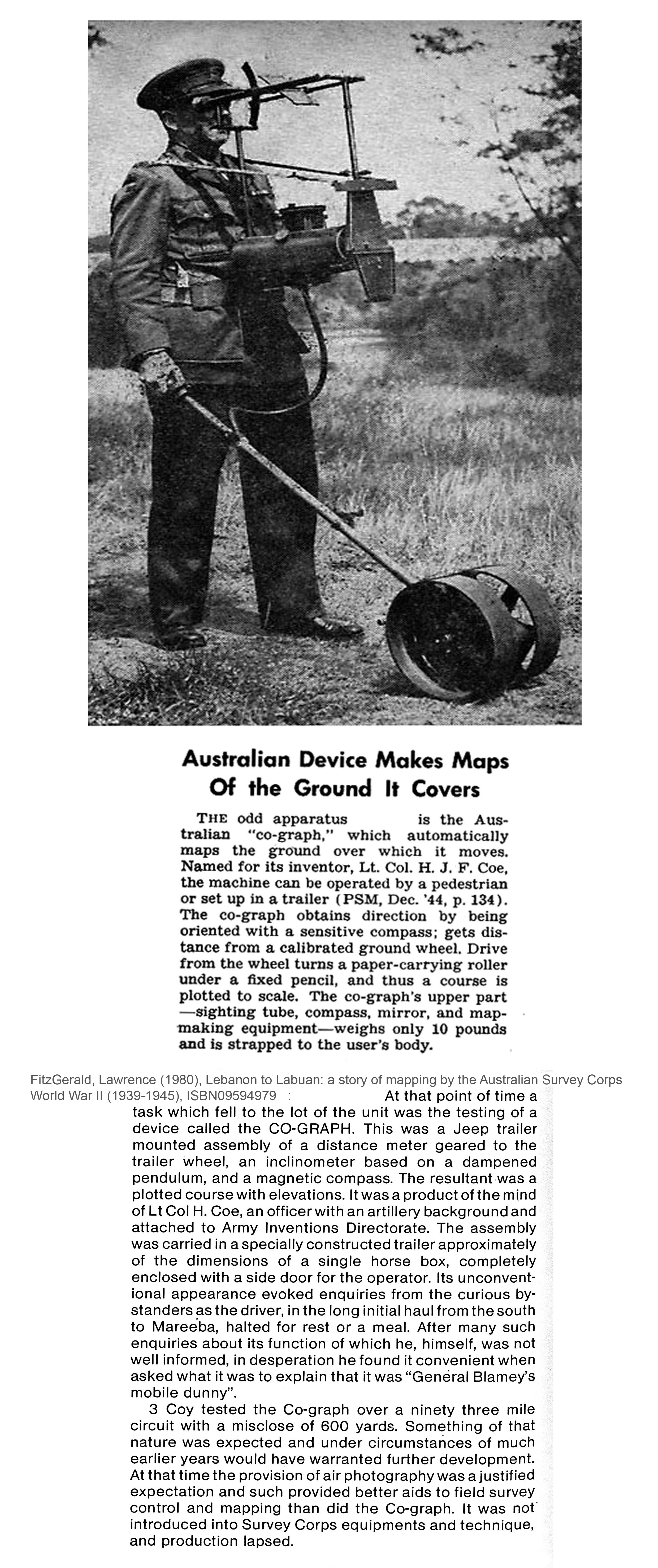
- Early machines for making maps on the move - read about the Co-graph and the Odograph.
|
|