MAP SERIES AND ASSOCIATED MAP SHEET IDENTIFICATION
Introduction
Most series of maps have an associated map index. Such an index shows the geographic extents of the maps of the series, the map names and/or their relevant alpha, numeric or alpha-numeric identifiers. The derivation of these identifiers is described in this edited extract of a 1993 letter from the former Director of Survey, Colonel Nathaniel Rickards John John Hillier, as published in the Royal Australian Survey Corps Association 2013 ACT Newsletter, Issue 3/13, pages 3-15.
Pre Federation colonial mapping was only undertaken when capability and resources allowed. Not much changed with Federation other than the Commonwealth was able to now undertake mapping for its own needs. Much of this mapping was confined to cadastral maps depicting land parcel boundaries with only very limited topographical information incorporated. The Army alone was the only Commonwealth agency with a charter for mapping and that was very limited and confined to mapping for its own needs. It was not until the 1945 establishment of the National Mapping Council that topographical mapping at various scales for Commonwealth, Military and State purposes was agreed, thus avoiding duplication of effort and maximising the use of resources.
Pre 1942
Post Federation, and from 1908 one inch or one inch to one mile (1:63,360) scale maps were known as Manoeuvre Maps, Sketch Maps and later Tactical Maps.
In some cases, these maps did not conform to any standard size format nor did they provide any geographic information apart from the map name.
Sheet boundaries for the one inch scale maps were designed in 1908 as a breakdown of the 1:1,000,000 scale International Map of the World (IMW) series.
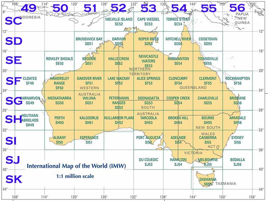
Figure 1 : International Map of the World (IMW), 1:1,000,000 scale map series indicative index showing the 50 map sheets covering Australia with today’s alpha-numeric identification grid highlighted.
(Note the un-named sheet between Esperance and Port Augusta was included in the fifty)
Map sheets of the IMW series cover 6° of longitude by 4° of latitude. The original numbering of the IMW map series over Australia was simply from 1 to 50 with Sheet 1 covering Melville Island and Sheet 50 Tasmania. Refer Figure 1 for indicative map sheet layout. Each 1:1,000,000 scale map sheet area was then subdivided into 24 squares of 1° longitude by 1° latitude identified by the letters A to X from the northwest corner to the southeast corner respectively. Each 1° square was then quartered and identified with Roman numerals, I to IV respectively for each 30' square. Each 30' square then represented the area covered by a one inch to one mile scale map sheet. Refer Figure 2 below showing a generic 1:1,000,000 scale map sheet with its 6 by 4 degree grid and grey shading indicating the area of a single one degree square and the Roman numerals, four, one inch to one mile scale map sheet areas.
|
A |
B |
C |
D |
E |
F |
|
||||||
|
I |
II |
|
|
|
|
|
|
|
|
|
|
F |
|
III |
IV |
|
|
|
|
|
|
|
|
|
|
|
|
|
|
|
|
|
|
|
|
|
|
|
|
L |
|
|
|
|
|
|
|
|
|
|
|
|
|
|
|
|
|
|
|
|
|
|
|
|
|
|
|
R |
|
|
|
|
|
|
|
|
|
|
|
|
|
|
|
|
|
|
|
|
|
|
|
|
|
|
|
X |
|
|
|
|
|
|
|
|
|
|
|
|
|
|
Figure 2 : A generic 1:1,000,000 scale, 6 by 4 degree map sheet area, with the grey shading indicating the area of a single 1 degree square, and the Roman numerals four, one inch to one mile scale map sheet areas.
Post 1909, the black square represented the relative position of map sheet G 52/H II.
The International Map Committee in 1909 adopted the alpha-numeric system of sheet identification for the 1:1,000,000 scale IMW map series, as we know it today. The IMW map sheet alpha identifier starts at A at the equator and goes north and south to V near the poles at 88°. Sheet Z is centred on the poles and thus there is no requirement for Sheets W, X and Y. The numeric identifier starts at 1 at the Greenwich meridian and goes west to east, to 60. As shown in Figure 1 above, the IMW alpha-numeric identifiers in the Australian region run from C 49 to K 56. The full prefix to include S (for South) was not used until the introduction of the 1:250,000 scale map series in 1956. If the generic 1:1,000,000 map in Figure 2 above is say G 52, Petermann Ranges, then the black square represents the relative position of the one mile map sheet G 52/H II within this system of map identification. When adopted in Australia each 30' square was further split into a northern half and southern half thereby having two map sheets of 30' of longitude by 15' in latitude. Full identification of the one mile map sheet then became sheet G 52/H II N or S. A modification in 1927 split the northern and southern 30' of longitude by 15' in latitude map sheets into 15' squares identified as NE and NW and SE and SW. The full map sheet identifier then became sheet G 52/H II NE or NW or SE or SW.
A simple Transverse Mercator projection and corresponding yard grid (Clarke 1858 spheroid) was introduced in 1933. The projection covered the whole of Australia in 8 zones each 5° of longitude wide with a ½° of common overlap at zone edges. There was no provision for a scale factor and each zone’s true origin was at 34° South. Refer Figure 3. The one mile scale map sheet identification system was thus changed again. Each one mile scale map sheet was now identified by a number commencing at 1 in the northwest of Australia in each zone and sequentially increased to the south, within that zone. Refer Figure 4. In Tasmania the numbering again began with 1 in the northwest of a zone and extended in a southerly direction. The full identification was sheet number followed by the zone number. For example, sheet G 56/U III NE and NW, Number 131, Zone 8. This complex identification was dropped in 1942 in favour of just the zone and sheet number. For example, the one inch scale map named Darwin was 4/32 while the one inch scale map named Sale in Victoria, was 7/863.
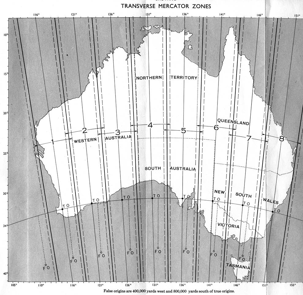
Figure 3 : Eight zone Transverse Mercator projection adopted for Australia in 1933.
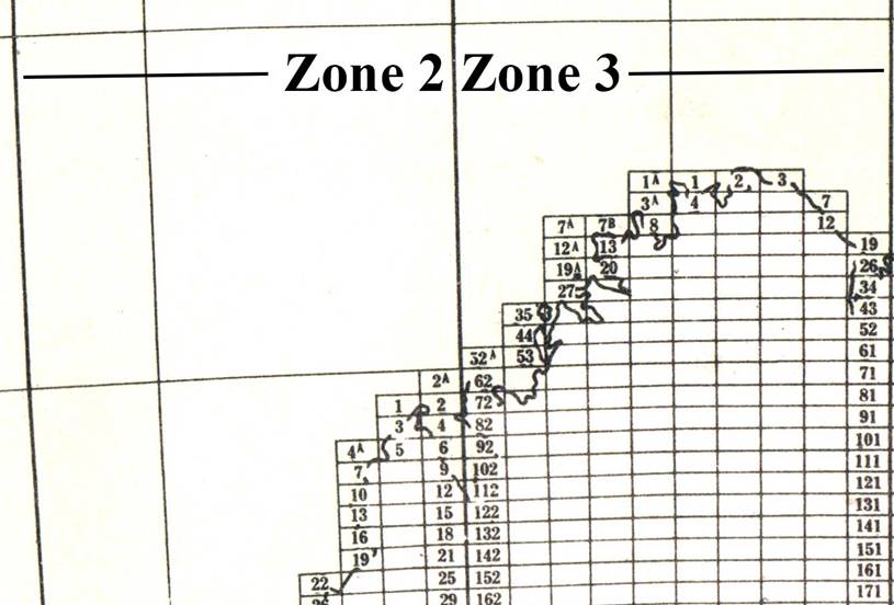
Figure 4 : Example of zones and associated map sheet numbering adopted in 1942.
Imperial Four Mile Scale Map Series and Metric 1:250,000 Scale Map Series
With its inception in 1940, the map sheet size for the imperial four miles to one inch (1:253,440) scale map series was set at 1° 30' longitude by 1° latitude, over mainland Australia. These extents were retained when the imperial 1:253,440 scale was replaced by the metric scale of 1:250,000, in 1956. Map sheet identification was still based on the IMW identification grid but each four miles to one inch scale map sheet was sequentially numbered from 1 in the NW to 16 in the SE corner of the 1:1,000,000 scale IMW map sheet area. The Melbourne four mile scale map sheet was thus identified as SJ 55-5. Refer example layout in Figure 5 below, of a generic 1:1,000,000 scale, 6 by 4 degree IMW map sheet area with sixteen 1° 30' longitude by 1° latitude four miles to one inch scale map sheets, and the black shaded area indicating the extent of a single 30' one inch to one mile scale map sheet.
|
1 |
2 |
3 |
4 |
|
||||||||
|
|
|
|
|
|
|
|
|
|
|
|
|
4 |
|
|
|
|
|
|
|
|
|
|
|
|
|
|
|
|
|
|
|
|
|
|
|
|
|
|
|
8 |
|
|
|
|
|
|
|
|
|
|
|
|
|
|
|
|
|
|
|
|
|
|
|
|
|
|
|
12 |
|
|
|
|
|
|
|
|
|
|
|
|
|
|
|
|
|
|
|
|
|
|
|
|
|
|
|
16 |
|
|
|
|
|
|
|
|
|
|
|
|
|
|
Figure 5 : A generic 1:1,000,000 scale, 6 by 4 degree IMW map sheet area with the black square representing the extent of a single 30' one inch to one mile scale map sheet.
In Tasmania the sheet size was extended in longitude to 2° by the civilian and military map agencies with the introduction of the 1:250,000 scale map series.
The 1:250,000 map scale, R502 series of maps was the first uniform medium scale topographic map coverage of Australia. The R502 series comprised a total of 540 printed maps. Refer map index at Figure 6. This series of maps was initially commenced around 1950 as the R501 series at a scale of 1:253,440 (4 miles to 1 inch). However, after some 23 map sheets were published metric map scales were introduced and these imperial scale maps were subsequently converted to the R502 series at the 1:250,000 metric scale. All R502 map sheet compilations were finalised by 1966 and the printing of all the maps of the series was completed in 1968. The R502 map series used the 1933 simple Transverse Mercator projection and corresponding yard grid (Clarke 1858 spheroid).
The R502 series received that designation based on the military system of the day. That system formed the designator from four descriptors being the major area covered, generally the country being mapped, the scale range of the series, the sub-area covered like state or region, and sequence in that scale range, first coverage, second etc. The designation R502 indicated; R for the Australian area, 5 that the scale range is between 1:150,000 and 1:255,000, 0 that there is no sub-area as the series covers the whole major area of Australia, and 2 that it is the second series in the 5th scale range. The earlier national series at a scale of four miles to one inch (1:253,440) was designated R501 and a national series at a scale of 8 miles to one inch (1:506,880) was designated R401 as the scale was between 1:510,000 and 1:255,000. Designators for other map series are detailed in Hillier’s letter.
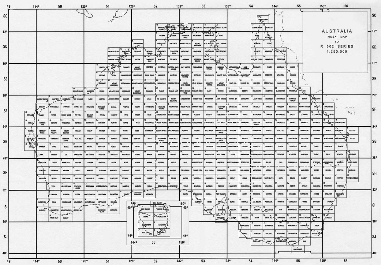
Figure 6 : Index map to the 1:250,000 scale R502 map series for Australia.
A zoomable version is available via this link.
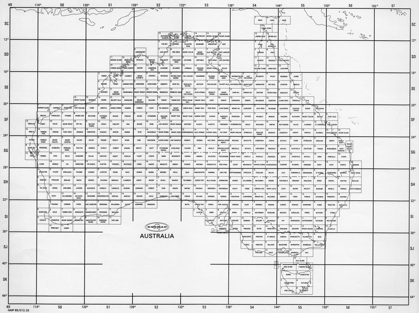
Figure 7 : Index map to the 1:250,000 scale National Topographic Map Series (NTMS) for Australia.
A PDF format version also showing the 1:100,000 scale map sheet identifiers may be downloaded from :
https://d28rz98at9flks.cloudfront.net/75410/100K_250K_Index_Front.pdf
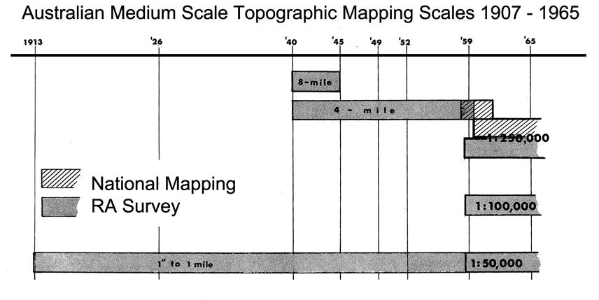
Figure 8 : Australian medium scale topographic mapping scales produced during the period 1907 to 1965.
National Topographic Map Series (NTMS)
In 1965, the Commonwealth government approved the acceleration of the national topographic mapping program with the object of completing mapping coverage of the country at 1:100,000 map scale with contours shown at 20 metre vertical intervals. The National Topographic Map Series program involved compilation of 3,062 sheets (30' longitude by 30' latitude) at 1:100,000 scale. However, only 1,602 of these sheets (generally covering the more populated areas) were printed as 1:100,000 scale topographic maps. This program was finalised in 1988.
The Universal Transverse Mercator projection (Australian National Spheroid, 1966) was used as the basis of the then new Australian Map Grid (AMG) with the Equator as origin and zones 6° of longitude wide with ½° of zone overlap and with 0.9996 point scale factor.
As mentioned above, the NTMS 1:250,000 scale map series largely retained the same 1° 30' longitude by 1° latitude extents, over mainland Australia, as for the R502 series. The map sheet extents were enlarged, however when practical, to encompass small sections of the mainland rather than have a few map sheets with little useful topography shown on them. The map index for the 1:250,000 scale NTMS is at Figure 7 and the 1:250,000 scale NTMS named Melbourne is identified as SJ 55-5.
Each 1:250,000 scale map areas contained six 1:100,000 scale map sheets each of 30' longitude by 30' latitude. The identification number for each of these 1:100,000 scale map sheets in Australia is a 4 digit number related to an arbitrarily selected origin at 48° 30' S and 106° 00' E so as to encompass then Australian territory but not major islands or Antarctica. This means that 1:100,000 scale map sheet 0000 has 106° 00' E, 48° 30' S as the coordinates of its south-west corner. The 1:100,000 scale NTMS named Melbourne is identified as 7822.
The 1:100,000 scale map compilations were used to prepare and publish the new 1:250,000 scale map NTMS of 544 map sheets. This map series covered the whole of Australia and had contours shown at 50 metre vertical intervals.
Metric 1:50,000 and 1:25,000 Map Scale Series
Each 1:100,000 scale map sheet of 30' longitude by 30' latitude can be further subdivided into four 1:50,000 scale map sheets of 15' longitude by 15' latitude numbered clockwise from the north-west quadrant as shown below.
|
4 |
1 |
|
3 |
2 |
Each 1:50,000 scale map sheet of 15' longitude by 15' latitude can again be further subdivided into four 1:25,000 scale map sheets of 7.5' longitude by 7.5' latitude numbered clockwise from the north-west quadrant as shown above. However, the subdivision can also be two 1:25,000 scale map sheets of 15' longitude by 7.5' latitude indicated as N for north map and S for south map. The map format and hence identifier, largely depended on the responsible mapping agency. The hierarchy of Australian medium scale metric map series is summarised in the following table.
|
Hierarchy of Australian medium scale metric map series |
||
|
Map scale |
Extent (degrees of longitude and latitude) |
Number of map sheets at that scale to cover the same area as that of a single map sheet at the scale above |
|
1:1,000,000 |
6 x 4 |
NA |
|
1:250,000 |
1.5 x 1 |
16 |
|
1:100,000 |
0.5 x 0.5 |
6 |
|
1:50,000 |
0.25 x 0.25 |
4 |
|
1:25,000 |
0.125 x 0.125 |
4 |
Map Projection and Grids
The Polyconic projection was used for the preparation of the Sketch Maps and Tactical Maps at 1:63,360 scale (based on the Clarke 1866 Spheroid) exclusively until 1936. The British Modified Grid, based on Clarke 1858 Spheroid, which was a Transverse Mercator Grid superimposed on the Polyconic projection, was adopted in March 1933 and introduced with the Albury one inch scale map printed in June 1933. The 1933 British Modified grid was spaced at 1,000 yard intervals with every tenth grid line thickened.
When first published, the imperial four miles to one inch scale map series grid reference, was an arbitrary alpha-numeric array but was changed to the Transverse Mercator grid reference system having 10,000 yard grid squares in 1936.
The British Modified Grid was also quickly abandoned with the Transverse Mercator projection being shown on the 1936 one inch scale map, Helidon, Number 191 Zone 8 in Queensland.
With the introduction in 1966 of the Australian Map Grid (AMG), metric units became standard for all grids printed on maps from 1:250,000 scale through to 1:25,000 scale. Almost half of the R502 series maps were reprinted, and during this process the 10,000 metre AMG grid was overprinted in cyan.
Australian Medium Scale Topographic Map Coverage
The following links provide current information on national topographic maps :
|
- |
Downloads PDF format index map to the 1:1,000,000, 1:250,000 and 1;100,000 scale map series. |
|
- |
Download page for NATMAP, 2013, Map Reading guide : How to Use Topographic Maps. 3 ed. Geoscience Australia, Canberra. |
|
- |
NATMAP, 1979, Map Reading guide : How to Use Topographic Maps. Older on-line version. |
Acknowledgement
Thanks to RF Bob Skitch (Lieutenant Colonel - Retired) for his pre-publication review of the article.
Paul Wise, February 2016