AN ACCOUNT OF THE BOUNDARIES OF THE AUSTRAL-ASIAN COLONIES.
BY W. D. CAMPBELL, Licensed
Surveyor, and Assoc. M. INST. C.E.
Read 12th November, 1894.
CONTENTS
NEW SOUTH WALES
|
|
An account of the boundaries of the Colony of New South Wales comprises that of the greater part of Australia, and its various portions will therefore be dealt with chronologically in the present paper. Marine discoveries and surveys will not be dealt with.
The Royal Commission to Governor Phillip, which was read on 7th February, 1788, at Sydney, a few days after the formation of the first settlement, declared the territory of New South Wales and its dependencies "to extend from the northern Cape or extremity of the coast called Cape York, in latitude 10° 37' to the southern extremity of the said territory of New South Wales, or South Cape, in latitude 43° 39', and including all islands adjacent in the Pacific Ocean within those latitudes, and all the country inland to the westward as far as the 135° of E. longitude." (See Historical Records of N.S.W., vol. I., part 2, p. 24).
Figure 1 shows the original Diagrams 1 and 2 combined with the heavy line indicating the outline of the territory as then known (see map at p. 93 Official History of New South Wales), placed in juxtaposition with the correct outline of Australia.
This extensive tract of territory has been reduced by the separation of Van Diemen's Land, the creation of the province of South Australia, the separation of Victoria and Queensland, and the transfers of "No Man's Land" and the Northern Territory to South Australia, to its present limits, which are on the south from Cape Howe along the Murray River to the South Australian boundary at the 141st meridian, and on the north from Point Danger along the Macpherson Range and McIntyre River and the 29th parallel of latitude to the above-mentioned boundary of South Australia. (See Figure 1). Details of these boundaries and their proclamation, survey, and marking will be given when treating of the several territories separated and affected.
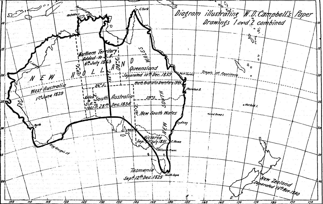
Figure 1 : Showing the original Diagrams 1 and 2 combined with the heavy line indicating the outline of the territory as then known placed in juxtaposition with the correct outline of Australia.
This extensive tract of territory was reduced by the separation of Van Diemen's Land, the creation of the province of South Australia, the separation of Victoria and Queensland, and the transfers of "No Man's Land" and the Northern Territory to South Australia, to its present limits, which are on the south from Cape Howe along the Murray River to the South Australian boundary at the 141st meridian, and on the north from Point Danger along the Macpherson Range and McIntyre River and the 29th parallel of latitude to the above-mentioned boundary of South Australia.
VAN DIEMEN'S LAND
Van Diemen's Land was discovered to be an island in 1797, and in 1804 Colonel Collins and Lieut.-Colonel Paterson founded the settlements at Hobart Town and Port Dalrymple. The growth of settlement and its isolated character gradually caused efforts to be made for its separation from New South Wales, and an Act 4 Geo. IV., c. 96 was passed by the Imperial Government "for the better administration of justice in New South Wales and Van Diemen's Land, and for the better government thereof" (19th July, 1823), which provided in the 44th clause for the separation of Van Diemen's Land from New South Wales (see Callaghan's Acts relating to New South Wales, p. 202), and the Sydney Gazette of 9th January, 1826, contained a proclamation issued by Colonel Geo. Arthur, Lieutenant-Governor of Van Diemen's Land and its dependencies, dated 12th December, 1825, by virtue of an order of His Majesty of 14th June preceding.
The following recital from His Excellency's proclamation shows the limits of the separated jurisdiction, the Governor of New South Wales being made now Governor-General of Australia :-
"Whereas His Majesty having erected this His Majesty's Island of Van Diemen's Land and its dependencies hereinafter mentioned into a separate Colony, independent of the Government of New South Wales, has been most graciously pleased by his Royal Letters Patent, under the Great Seal of Great Britain and Ireland, bearing date at Westminster the sixteenth day of July in the sixth year of His Majesty's Reign, to appoint His Excellency Lieutenant-General Ralph Darling, to be Captain-General and Governor-in-Chief in and over the said island and all islands and territories lying to the southward of Wilson's Promontory in thirty-nine degrees and twelve minutes of South latitude, and to the northward of the forty-fifth degree of South latitude, and between the one hundred and fortieth and one hundred and fiftieth degrees of longitude, East from Greenwich ; and also Macquarie Island, lying to the southward of the said Island of Van Diemen's Land, with, under and subject to the several powers and provisions contained therein," &c.
The islands included in the above proclamation are situated chiefly in Bass' Straits, and are 55 in number, according to the official Colonization Circular of 1874. One of them, Macquarie Island, is a bare rock frequented by seals, without a tree or shrub, about 18 miles long and 5 miles broad, in 54° 35' S. latitude and 159° 3' 45" E. longitude, about 850 miles south-easterly from Tasmania, and about 600 miles south-west from New Zealand. Its proximity to the Auckland and Campbell Islands belonging to that colony has caused the New Zealand Government in August, 1894, to propose negotiations with a view to this island being ceded by Tasmania to New Zealand, in order to make it a basis of operations against poachers. A similar request was made four years previously, but was rejected by the Tasmanian Parliament. An account of Macquarie Island, by Prof. J. H. Scott, M.D., appeared in the Trans. Instit. of New Zealand, vol. XV., 1882, p. 484.
The name of Tasmania was substituted for that of Van Diemen's Land by order of Her Majesty in Council at Osborne House on 21st July, 1855, in response to a petition of the Parliament of Van Diemen's Land, and it was proclaimed on let January, 1856.
NORFOLK ISLAND
Norfolk Island, situated about 900 miles east of Brisbane, is about 8528 acres in extent, with a length of nearly 5 miles, and an average breadth of 2½ miles.
Governor Phillip was instructed by the British Government to occupy this island for the purpose of raising wheat and other crops for the New South Wales settlement, the fertility of the soil having been noted by Captain Cook; and Lieutenant King was accordingly dispatched with a small party of convicts to occupy it, landing there on 3rd March, 1788. Ex-Governor Hunter visited the island in 1800 on his return voyage to England, and recommended its abandonment, and on the 22nd July a notification appeared in the Sydney Gazette stating that orders had been received for the removal of part of the Norfolk Island establishment.
In 1805 a despatch was received by Governor Bligh, dated Dec., 1804, ordering the evacuation of the island to be completed. (See Spruson's Account of Norfolk Island, 1885.) The rebellion of the New South Wales Corps on 26th January, 1808, probably delayed the carrying out of this order, as it was not till 1813 that the remainder was removed, some to Van Diemen's Land and the rest to New South Wales (see Sydney Gazette, 8th May, 1813).
Possession of the island was resumed by the British Government in 1824, and it was appointed one of the places to which offenders convicted in New South Wales, and under sentence of transportation, might be sent or transported, by order of His Majesty, dated Carlton House, 11th December, 1825.
It was severed from the Government of New South Wales and diocese of Australia and annexed to the Government and colony of Van Diemen's Land, and to the diocese of Tasmania by commission of Her Majesty by letters patent, dated 24th October, 1844, from and after 29th September, 1844 (see New South Wales Gazette, No. 85, of 17th September, 1844, vol. 2, p. 1142), power to issue such commission having been given by Act of Parliament, 6 and 7 Vic., chap. 35 : "To amend so much of an Act of last session for the government of New South Wales and Van Diemen's Land as relates to Norfolk Island" (28th July, 1843). This island being to the southward of the 26th degree of S. latitude, a special revision of Act 5 and 6 Vic. c. 76 was made by the same Act, as all such territory had been by it described as not to be detached from New South Wales.
A despatch from Earl Grey to Lieutenant-Governor Sir William Denison, dated 30th September, 1846, directed that the island was to be abandoned, and the entire establishment was by degrees removed to Port Arthur, in Van Diemen's Land, being finally broken up in 1856.
At the instance of Bishop Wilson, an order of Her Majesty in Council at Court at Windsor, 29th December, 1853, declared Norfolk Island to be no longer a place for the transportation of felons (see Hobart Town Gazette, 20th March, 1854).
By an order of Her Majesty in Council at the Court at Buckingham Palace, on 24th June, 1856, it was directed that "the said island called Norfolk Island shall be, and the same is hereby, separated from the said colony of Van Diemen's Land (now called Tasmania) . . . . the said island called Norfolk Island shall be a distinct and separate settlement, and that the Governor for the time being in and over the colony of New South Wales shall be the Governor of Norfolk Island" (see Hobart Town Gazette of 24th October, 1856, and New South Wales Gazette of 1st November, 1856, p. 2815, proclamation of 31st October, 1856).
In June, 1856, the community of Pitcairn Islanders was brought here, having outgrown Pitcairn Island, which they had hitherto occupied, the vessel which brought them being used to complete the removal of the convict establishment to Tasmania.
Sir William Denison visited the island in 1857, and arranged a scheme of government. The Governor of New South Wales for the time being is also the Governor of Norfolk Island, but under a separate commission, holding also a great seal for that little colony. Each year, at Christmas, the people elect a chief magistrate and two councillors, and these officers hold the executive power, subject to the control of the Governor, whose power is plenary, both to make laws and administer them. Governor Loftus, after his visit in 1884, communicated with the home authorities, resulting in the Colonial Office requesting the Government of New South Wales, in a despatch dated 13th November, 1885, to undertake the control of the island (see Votes and Proceedings, 1885-6, vol. ii., p. 223). This was agreed to by the Government, but subsequently a change of Government taking place, the new Premier, Sir Henry Parkes, after considerable delay, finally decided not to have anything to do with the island, and therefore the Government remains as before.
Lord Howe Island has since its discovery on 17th February, 1788, been a dependency of New South Wales. Since the separation of New Zealand in 1846, it has been the most remote dependency of New South Wales, being 300 miles due east from Port Macquarie. It is 7 miles long, and from 1/3 to 1¾ mile in width.
NEW ZEALAND
New Zealand was considered to be included in the commission of the Governor of New South Wales until the formation in Sydney, on 8th January, 1814, of the New South Wales Society for the Protection and Civilisation of the Natives of the South Sea Islands, of which the Rev. Samuel Marsden was Secretary. This work was taken up and continued by the Church Missionary Society.
A proclamation, dated 1st December, 1813, was published on 4th December, Governor Macquarie stating that in consequence of complaint made of conduct of divers masters of ships, it is notified that the natives of New Zealand, of Otaheite and of the other islands in the Pacific Ocean, are under the protection of His Majesty. A Government order, dated 9th November, 1814, appeared in the Sydney Gazette of 19th November, 1814, appointing Mr. Thos. Kendal, a missionary, a J.P. in the Bay of Islands in New Zealand and throughout the islands of New Zealand, and declaring "His Excellency being equally solicitous to protect the natives of New Zealand and Bay of Islands in all their just rights and privileges, as those of every other dependency of the territory of New South Wales, no one is to remove any of the natives" without permission in writing from Mr. Kendal, the resident magistrate, or the magistrate for the time being in said districts. An order of 24th July, 1819, appointed the Rev. John Butler a J.P. and magistrate in the island of New Zealand. The avowed policy of the Missionary Society was to prevent European colonisation and to govern the natives through the medium of the missionaries. In 1825, however, when a commercial company was formed in London under the auspices of the Earl of Durham to effect a settlement at the River Thames, two vessels were dispatched in 1826 with a party of 50 men; they were placed under the protection of the Government of New South Wales, but the settlement did not prosper, and was eventually abandoned. Otaheite was probably considered to be under a protectorate of New South Wales, as on 28th September, 1811, Mr. William Henry, a missionary, was appointed a magistrate and Justice of the Peace there.
In Act 9, George IV., c. 83, "to provide for the administration of justice in New South Wales and Van Diemen's Land" (25th July, 1828), clause 4, New Zealand is mentioned with Otaheite as not subject to British or other European law. Tahiti (or Otaheite) was seized by the French in 1847, and made a penal settlement, and New Caledonia shared the same fate in 1853.
In 1835, when New Zealand was threatened with aggression by Baron de Thierry, a national flag was supposed to be adopted by the natives, and a declaration of independence was issued under missionary auspices, and Mr. James Busby was sent there by the New South Wales Government with the title of "Resident." It was feared in Great Britain, however, that the French intended to occupy New Zealand and establish a penal settlement. The New Zealand company was thereupon patriotically formed to colonise the country; and although they were refused a charter, the settlement at Wellington was founded on 22nd January, 1840.
The British Government being forced to action obtained the opinion of the law officers of the Crown as to the sufficiency of the Act 9, George IV., c. 83, for administering legal control in New Zealand. The opinion, dated 4th June, 1839, stating that the Courts of Justice established by the Act were to have jurisdiction not only over the then existing dependencies, but also over all islands and territory which might thereafter become dependent on the Government of New South Wales (see Votes and Proceedings, New South Wales, 1840, p. 189). The New South Wales Government accordingly passed an Act, 3 Vic., No. 28, which declared the laws of New South Wales to extend to New Zealand (16th June, 1840), and a proclamation to this effect appeared in the New South Wales Gazette, No. 40, of 4th July, 1840, p. 641.
In a proclamation, dated 14th January, 1840, so much, of Sir George Gipps' commission under letters patent of 5th October, 1837, were declared to be revoked and superseded by another under letters patent of 15th June, 1839, as describes the limits of Her Majesty's said territory of New South Wales, and to further extend the limits thereof, so as to include any territory which is or may be acquired in sovereignty by Her Majesty, her heir and successors, within that group of islands in the Pacific Ocean, commonly called New Zealand, and lying between the latitudes of 34° 30' and 47° 10' S. latitude, and 166° 5' and 179° E. longitude, and appointing Wm. Hobson to be Lieut.-Governor over that part of Her Majesty's territory aforesaid (see New South Wales Gazette, No. 4, of 18th January, 1840, P. 65). Capt. Hobson, R.N., received also the appointment of Consul for the same territory.
A despatch, dated Downing-street, 14th August, 1839, from the Marquis of Normanby to Sir George Gipps, was as follows :-
"Sir, - Your appointment to the office of Her Majesty's Consul at New Zealand having been signified to you by Viscount Palmerston . . . the Minister of the Crown having been restrained from engaging in the enterprise (of settlement), deferring to advice of committee approved by the House of Commons, 1836, to enquire into the state of aborigines residing in vicinity of our colonial settlements, and have concurred with that committee in thinking that the increase of national wealth and power promised by the acquisition of New Zealand would be a most inadequate compensation for the injury which must be inflicted on this Kingdom itself by embarking in a measure essentially unjust, and but too certainly fraught with calamity to a numerous and inoffensive people, whose title to the soil and to the sovereignty of New Zealand is indisputable, and has been solemnly recognised by the British Government. The necessity for the interposition of the Government has, however, become too evident to admit of any further inaction" (see Votes and Proceedings, New South Wales, 1840, p. 179).
Capt. Hobson effected the treaty of Waitangi, which, while recognising the natives as owners of the soil, the British sovereignty was-acceded by the natives (see New South Wales Gazette, No. 41, of 8th July, 1840, p. 644, proclamation dated Russell, 21st iv, 1840).
An Act, 3 and 4 Vic., c. 62, "for the administration of justice in New South Wales and Van Diemen's Land, and for the more effectual government thereof" (7th August, 1840), empowered Her Majesty to erect into a separate colony or colonies any islands which then were, or which thereafter might be comprised within, and be dependencies of the-colony of New South Wales.
The proclamation of New Zealand as an independent colony took place on 2nd April, 1841, in the New South Wales Gazette, No. 26, and re-published also a notice, dated 20th November, 1840, in the London Gazette of 24th November, 1840.
In Act 9 and 10 Vic., c. 103, "to make further provision for the government of the New Zealand islands" (28th August, 1846), it is stated that by letters patent of 16th November, 1840, Her Majesty erected into a "separate colony the islands of New Zealand, theretofore comprised within or a dependency of New South Wales, with all other islands lying between 34° 30' to the 47° 10' S. latitude, and between 166° 5' to the 179° of east longitude."
The boundaries of the colony were extended southwards in 1863, so as to include the Chatham and Auckland Islands and Campbell and Bounty Island. Act 26 and 27 Vic., c. 23, "to alter the boundaries of New Zealand" (8th June, 1863), describes the boundaries as including all islands within 162° E. and 173° W. longitude, and 33° and 53° parallels of S. latitude.
The Kermadec group of islands were annexed to New Zealand by Capt. Clayton, of H.M.S. "Diamond," on 17th August, 1886 (see New Zealand Gazette, 1887, p. 954). The islands are four in number, with some outlying islands. The principal island is almost exactly the same distance from Auckland to the north-east as Norfolk Island is to the north-west, viz., 600 nautical miles (see account of the Kermadec Islands by S. P. Smith, Assistant Surveyor-General, 1887). Norfolk Island was likely at one time to have been attached to New Zealand, as Lord Belmore, when Governor of New South Wales, is stated to have offered to transfer the Governorship of Norfolk Island to New Zealand, but it was not accepted by the islanders (see Sydney Morning Heralds 27th October, 1886).
About 1890 a protectorate was established by the Imperial authorities over the Cook group, of which Raratonga is the principal island; and the New Zealand Government nominated Mr. F. J. Moss as British representative, and he assumed his duties early in 1891.
In order to warn off any French designs on the northern portion of Australia then beyond the limits of New South Wales, a military settlement was formed in 1824 at Port Essington, under Sir J. J. Bremer, but it was abandoned in 1826. In 1838 it was again occupied, as was also Melville Island, in consequence of its being discovered that an expedition was being fitted out at Toulon to occupy a portion of Northern Australia (see "Enterprise in Tropical Australia," by G. W. Earl, 1846), but this territory was now included within New South Wales by the alteration, in 1830, of the New South Wales boundary line to the 129th degree of east longitude by the Imperial Government. This settlement was abandoned in 1850.
WEST AUSTRALIA
King George's Sound was occupied as a precautionary measure in 1826 by Major Lockyer, of the 39th Regiment, with a small detachment of soldiers and convicts ; but they were withdrawn four years afterwards, when the settlement at Swan River had been formed by Capt. Sterling, on 1st June, 1829, Capt. Fremantle having previously in that year taken possession of all the land in Australia not included in the colony of New South Wales, in pursuance of Act 10, George IV., c. 22, "to provide until 31st December, 1834, for the government of His Majesty's settlement in West Australia, on the western coast of New Holland" (14th May, 1829), which Act declared that no part of the colonies of New South Wales and Van Diemen's Land, as at present established, shall be comprised within the said new colony.
In 1831 a commission was issued to Capt. Sterling, then Lieut.- Governor, appointing him Governor and Commander-in-Chief of His Majesty's settlement on the west coast of Australia, or New Holland, and by letters patent Vice Admiral, the limits of his authority being from Cape Londonderry (latitude 13° 44') to West Cape Howe (latitude 35° 8' S.), and from Hartog's Island, 112° 52' to 129° E. longitude. The boundaries of the colony were defined in the supplementary commissions granted to the Governor in 1873, "as extending from the parallel of 13° 30' S. latitude to West Cape Howe in the parallel of 35° 8' S. latitude, and from Hartog's Island, on the western coast, in longitude 112° 52' to 120° E. longitude, reckoning from the meridian of Greenwich, including all the islands adjacent in the Indian Ocean, within the latitudes and longitudes aforesaid."
SOUTH AUSTRALIA.
The province of South Australia had its origin in negotiations opened with the Colonial Office in 1831 by a few gentlemen, for giving effect to the Wakefield system of land sale and free labour, and influenced by the discoveries made by Capt. Sturt in 1830 of the course of the River Murray, and the country traversed by it. A provisional committee of the South Australian Land Company was formed in 1832; and a draft charter was submitted by Colonel Torrens, but it was declined by. Lord Goderich, one of the reasons being stated to be that it would encroach on the existing limits of New South Wales and Western Australia. The alteration of boundary in 1830 between these two latter colonies, from the 135° to the 129° E. longitude, was possibly made with a view to the formation of a settlement in this portion of Australia.
In consequence of fresh negotiations, in which the now existing position of the colony was arranged, without apparently any consultation with the Government of New South Wales, an Act, 4 and 5 William IV., c. 95, was passed, to empower His Majesty to erect South Australia into a British province or provinces, and to provide for the colonisation and government thereof" (15th August, 1834), and eight " colonisation commissioners for South Australia " were selected from the South Australian Association, and by Royal warrant were gazetted in May, 1835, to manage the affairs of the scheme of settlement. The boundaries of the province were defined in the above Act as being the 132° and 141° E. longitude, and the Southern Ocean and 26' S. latitude, including Kangaroo Island, and all and every other island adjacent to that island, or any part of the main land of said province. Governor Hindmarsh, R.N., proclaimed the colony on 28th December, 1836, by virtue of letters patent of 19th February, 1836. Acts 1 and 2 Vic., c. 60 (assented to 31st July, 1838), amended the administrative arrangements of the last-named Act, but not the boundaries.
In 1839, in order to ascertain the correct position of the 141st
meridian, the boundary line with South Australia, in consequence of its position
having been shown differently on the 'map of Mr. Arrow-smith and that of Sir
Thomas Mitchell, Governor Sir George Gipps instructed Mr. C. J. Tyers (formerly
an Admiralty surveyor and then on the survey staff) to make an expedition for
this purpose (see despatch from Sir George Gipps to Secretary of State for the
Colonies, transmitting a report on the progress of discovery and occupation of
the colony during the period of his administration, printed 9th March, 1841,
No. 120, in vol. 29, British Parliamentary Papers, Sydney Free Library). Tyers'
expedition resulted in the mouth of the Glenelg being considered to be a little
eastward of 141st meridian, and consequently within the colony of New South
Wales, now Victoria (see also Inquiry of 1855, p. 20, Additional Appendix,
Votes and Proceedings, New South Wales, 1855, vol. 2, p. 111). Dr. Arrowsmith's
map, published on 5th February, 1840, appeared also as appendix A of Report of
Select Committee on South Australia, printed 10th June, 1841, p. 272. This
showed the 141st meridian to be about three miles east of the River Glenelg.
Sir Thomas Mitchell's map, published in 1848, which appeared in his "Three
Expeditions into the Interior of Australia," placed the 141st meridian at
Cape Northumberland, about 16 miles west of the same river. In the 1851
edition, Mr. Arrowsmith altered the 141st meridian close to the east aide of
entrance of the river, which is apparently the correct position, and Wade's
line is shown by a dotted line. The report made was also printed specially in
pamphlet form, and given to the various surveyors as a typical work. Three different methods were adopted by Mr. Tyers, viz. : triangulation
from Melbourne, chronometric measurement from Sydney, lunar observations near
the boundary and at Portland Bay. For astronomical observations, the
instruments used were an 8-inch sextant and artificial horizon ; for
triangulation, an 8½-inch theodolite. (This was erroneously printed in the 1855
Inquiry into the Survey Department as 3½ inches, and so quoted by the author on
p. 54 of our journal in March last ; but a copy of Mr. Tyers' pamphlet having
since been presented to the Institution by Mr. J. F. Mann, the correction is
now made). The party left Sydney on 15th September, 1839, in the Pyremus, "and arrived
at Melbourne on 1st October. After measuring the meridian distance from Sydney
to Batman's Hill, they left for Geelong on 8th October, and arrived at the
Glenelg on 16th December, having en route made a principal observatory at
Portland Bay. Mr. T. S. Townsend, who was assisting him, made a circumferenter
and chain survey of the whole of the route. The triangulation was completed on
the return journey. The two bases used were between Mount Eckersley and Mount
Sturgeon, and Mount Eckersley and Cape Sir William Grant were astronomically
determined. The latitudes were determined by circum "meridian"
(polar) observations of stars. The results of the work gave the east point of
entrance of the Glenelg River to be By lunar observations 141°
1 59 By chronometric 141°
1 43 By triangulation 141°
0 28 141° 1' 23.3 and thus to be in New South Wales territory. An approximate
position for the boundary was chosen for marking before this was worked out on
the east side of the Glenelg River, and run a few miles inland, nearly
bisecting the basin formed by the river near the coast. The amended position
was about 11 mile westward of the west entrance of the Glenelg River (see
Figure 2 – originally Diagram 3), which shows the sketch attached to Mr. Tyers
report with his two lines, and the positions of later determinations). The
necessity for altering further westward the line marked by Mr. Tyers is
explained by the following letter from John Arrowsmith to the Times, and
reprinted in the South Australian Register, of 18th September, 1841, in which
he vindicates the position of the 141st meridian shown on his plan. Fort
Macquarie, referred to by him, is 49.38 chains east of the time ball staff,
Sydney Observatory :‑ Sir,—Having read in the Times
of Tuesday a statement to the effect that the 141st meridian of E.
longitude had been determined to be on the west side of the River Glenelg,
"contrary to what had been laid down in Arrowsmith's map, published under
the authority of the South Australian Company," I trust that you will
allow me through your valuable paper to vindicate the accuracy of my work, as
well as my title to the entire authorship of it. In the first place, I must
remark that my map was constructed without the knowledge or participation of
the South Australian Company, which is not thereby in any degree responsible
for the position which their boundary line bears with reference to the Glenelg
in my map. Now as to the main point at issue. It is venturing much too far to
say that the meridian line separating South Australia from New South Wales has
been definitely settled by Mr. Tyers, who has, nevertheless, contributed all
that his opportunities allowed towards the solution of that question. But a
geographer must know that the determination of a meridian is not to be effected
by a single effort or hasty exertion. Mr. Tyers could do no more in the way of
astronomical observation for determining the mouth of the Glenelg than had been
done by Baudin, Flinders, Simonoff, Duperry, &c., for the longitude of
Sydney was long involved in an uncertainty of some miles. However, the
longitude of Fort Macquarie may be assumed with some confidence to be 151° 14'
40" E., the neighbouring Observatory of Parramatta reducing the errors of
this position to a trifle. Now, Sir, this point being ascertained, we have also
the difference of longitude between Fort Macquarie and Melbourne, determined by
Captains Hobson, Drinkwater, Bethune, Wickham, &c., with upwards of twenty
chronometers, which brings the latter place into longitude 144° 55' 55".
But here we find Mr. Tyers already three miles too far east in his calculations
at the commencement of his geodesical operations; and as his single chronometer
abridged the longitudinal distance between Sydney and Melbourne, why should it
not do so as much for the country further west between the latter place and
Glenelg? But if the distance between these places ascertained by Mr. Tyers
trigonometrically—the only measurement entitled under the circumstances to
much confidence—or 3° 59' to be subtracted from the true longitude of
Melbourne, we shall have 140° 50' 55' E,—or, in other words, we shall find the
mouth of the Glenelg to be west of the 141st meridian, or within one mile of
the position assigned to it on my map. Thus, Sir, you will perceive that the
question has not yet been settled in the way you suppose, and you will allow me
to say that nothing has been done or calculated to counterbalance the large
amount of authority which served me in the construction of my map. No. 10, Soho Square, Yours,
&c., 2nd April, 1841. JOHN
ARROWSMITH. Figure 2 : Originally Diagram 3 showing the amended position of
the Victorian/South Australian border was about 11 mile westward of the west
entrance of the Glenelg River. On 3rd September, 1844, Sir George Grey, Governor of South
Australia, wrote to Lord Stanley, drawing attention to the imperfect manner in
which the eastern and western boundaries of the province were then defined, and
proposing that certain natural features be taken for a portion at least of the
eastern boundary, commencing from the River Glenelg from its mouth to its
source, then along the River Wimmera and a line north to the River Murray, and
along that river as high as Laidley's Pond, and then along the 142nd degree of
east longitude. And in reply, Lord Stanley intimated his intention of
communicating with the Governors of N.S. Wales and W. Australia on the subject.
The proposal was reported upon by Sir Thomas Mitchell, Surveyor-General of New
South Wales, on 13th October, 1845, when he stated that the arguments now
adduced by the Governor of South Australia only add to other well-known facts,
evincing the necessity for the adoption of such well-defined natural limits,
and suggested that the River Murray should be taken as the boundary from
Laidley's Pond to the sea, and stated that he had endeavoured when in England
to rectify this, and that rivers formed a boundary marked by nature's own hand.
Sir Thomas Mitchell had suggested, in his account of "Three Expeditions
into the Interior of Eastern Australia," published in 1838, vol. 2, p.
326, that the "colony might extend northward to the tropic of Capricorn,
westward to the 145th degree of east longitude, the southern portion having for
boundaries the Darling, the Murray, and the sea coast." The superintendent of Port Phillip objected to the mixed character
of Sir George Grey's boundary, and the Executive Council of New South Wales
decided, on 3rd February, 1846, to adhere to the 141° boundary. They recommended
that commissioners be appointed by Her Majesty to lay down the boundary line,
but suggested that such commissioners should be authorised to deviate from the meridian
to a limited extent on either side, so as to adopt as boundary marks any
geographical features in the neighbourhood which might facilitate the
recognition of the frontier line. These matters were communicated to the Secretary
of State in a despatch, No. 91, of 29th April, 1846, which was referred to by
Earl Grey in a despatch of 31st July, 1847, to Governor Fitzroy, stating that
it will be his duty to take the necessary means for adjusting the questions
respecting the boundaries of New South Wales, South Australia and Western
Australia. On 15th July, 1846, Mr. Charles Bonney, one of the Commissioners
of Crown Lands for South Australia, addressed the following letter from the
Commissioner of Crown Lands Office : — Sir,—I have the honour
to report for the information of His Excellency the Lieut.-Governor my return
from the southeastern districts, where I have been lately engaged in settling
the boundaries of runs, preparatory to issuing of occupation licenses. I have
visited nearly all the runs in the district, and have taken such notes of the
boundaries as I hope will enable me to prepare the greater part of the licenses
which have been applied for. I would beg leave to call His Excellency's
attention to the necessity of having the eastern boundary of the provinces at
least approximately defined as soon as possible. The country through which it
passes is now occupied for 70 miles from the coast, and there are at least 12 or 14 settlers,
whose runs lie so near the boundary line that I considered my jurisdiction
over them uncertain, and therefore refrained from interfering with them. The
loss of the revenue is not the only evil resulting from the want of a defined
boundary. A number of bad characters resort to this neutral ground, knowing
that the police cannot interfere with them until the question of jurisdiction
is determined. In consequence of the swampy nature of the country through which
the boundary line passes, I do not think anything can be done in the matter
before the month of October. Lieut.-Governor Robe wrote to Governor Sir George Gipps on 22nd
July, 1846, enclosing an extract from the above letter, and stated that he
visited that portion of the province in the early part of the year, and that he
fully concurred with Mr. Bonney in thinking that the early determination of the
boundary of the province is very much to be desired. The above correspondence
being sent to Superintendent C. Latrobe at Port Phillip, he proposed, in a
letter dated 5th September, 1846, a commission to determine the boundary line,
which, if not entirely coincident with the 141st degree of east longitude,
shall run as close to it as circumstances permit. . . . Having fixed upon the
starting point on the coast near the mouth of the Glenelg River, whether the point
fixed by Sir Thomas Mitchell, that of Mr. Tyers, or that of Capt. Stokes, let a
line due north and south be run to the Murray River, sufficiently indicating
in greater or lesser intervals, according to the character of the country that
may be traversed, by marked trees, surface lines, or piles of stones, in the
same manner as is now done in the rough survey of boundaries, lines between
stations. . . . I would propose that, taking Mr. Tyers' point as the starting
point, a surveyor and six men should rendezvous at the Glenelg river mouth on
the 1st January, 1847, and proceed at once to run the line in question, in
conjunction with a similar party appointed by the Government (see Votes and
Proceedings, New South Wales, 1846, second session, p. 151. In February, 1846, the Government of South Australia appointed Mr.
Edward White to act with Mr. Henry Wade (representing New South Wales), in the
definition and marking of the boundary between the two colonies. A critical
examination was made by the Imperial authorities of three separate
determinations by three different officers at different times - 1st, that of
Mr. C. J. Tyers, in 1839, late of His Majesty's surveying ship
"Beagle"; 2nd, that of Commander Stanley, R.N., of Her Majesty's ship
"Britomart"; 3rd, that of Commander Stokes, in 1845, of Her
Majesty's ship "Beagle," a much higher value being given to Mr.
Tyers' work than to the others, and a position was selected - 16 chains by
scale west of his revised line on the west side of the Glenelg River, and 1
mile 42.50 chains from the west point of entrance.
Mr. Wade left Melbourne on 14th January, 1847, for this survey,
and started the line from the spot on the coast so selected, but had to abandon
it at the Tatiara Creek in 36° 13' 23" S. latitude after 123 miles had
been run, on account of the difficulty of obtaining supplies for the party (see
Imperial Parliamentary papers, 1850). On the plan of this boundary line scale,
8 miles to 1 inch, for which I am indebted to Mr. M. Callanan, Surveyor-General
of Victoria, the surveyors' notes describe the termination as being in a small
patch of heath, destitute of trees, where a large mound was erected with a
strong post in the centre — magnetic variation, 7° 12' E. The official plan is
signed Henry Wade, surveyor. The survey was continued by Mr. Edward R. White, a further
distance of 97 miles, in 1849, when it was temporarily stopped, the equipment
being buried at a point 206½ miles from the sea. It was re-continued in the
following year under more favourable conditions, water being found then in
holes in the rock, where there was none in 1849. After proceeding 26 miles the
party had to suspend their survey and push on to the Murray for water, then 34
miles distant, and shortly after returned and completed the work to the Murray.
The distance from Mr. Wade's termination being 157 miles and 280 from the sea,
on the return journey the equipment had to be buried again for a time, at 179
miles from the coast. A sand hill on the coast, three-quarters of a mile from
high-water mark, situated on Mr. Wade's line, was utilised by Mr. A. C. Allen
in 1859 or 1860 as a trigonometrical station of the Victorian geodetic survey,
and called Mount Ruskin. On 23rd December, 1847, the South Australian Government Gazette contained
a proclamation dated 16th December, by Governor Robe, which declared that‑ "Whereas from
the progress of settlement on the eastern frontier of the said province and on
the borders of the territory of New South Wales, it has become necessary to
mark out and ascertain the 141° of E. longitude, so fixed (by letters patent
dated 19th February, 1836) as the boundary of South Australia on the east as
aforesaid, and for this purpose, by an arrangement previously entered into, the
Government of New South Wales has, with the consent and concurrence of the
Government of South Australia, caused the position of the 141st meridian of longitude
east from Greenwich to correctly ascertained at a spot on the sea coast near
the mouth of the River Glenelg, and therefrom the said meridian to be surveyed
northward as far as the 36th parallel of South latitude by Henry Wade, Esq.,
surveyor, and to be marked upon the ground by a double row of blazing upon the
adjacent trees and by mounds of earth at intervals of one mile where no trees
exist. And whereas it is expedient that the said survey should be authoritatively
adopted and made known,-now therefore, by virtue and in pursuance of the power
and authority to me confided, I, the Lieutenant-Governor aforesaid, in name of
and on behalf of Her Most Gracious Majesty, do hereby notify and proclaim that
the line so marked as aforesaid, and particularly described in the schedule
hereto annexed, and delineated, on the public maps deposited at the Survey
Office at Adelaide as the meridian of the 141st degree of East longitude, is
and shall be deemed and construed to be the eastern boundary of the province of
South Australia to all intents and purposes." On 2nd March, 1849, the New South Wales Gazette, No. 31, contained
a proclamation to the same effect, dated 28th February, 1849, as follows :— "And whereas
it having become necessary to mark out and ascertain the said 141st degree of
east longitude between the said territory of New South Wales and the said
province of South Australia, an arrangement was entered into with the
Government of South Australia for that purpose, in consequence of which the
position of the 141st degree of East longitude has been correctly ascertained
at a point on the sea coast near the mouth of the River Glenelg, and therefrom
northward as far as the 36th parallel of South latitude. And whereas it is
expedient that the said boundary line so marked and surveyed should be made
known : Now, therefore, I, Sir Charles Fitzroy, as such Governor aforesaid, do
hereby notify and proclaim the line so marked and surveyed and particularly
described in the schedule hereto annexed, and delineated on the public maps in
the Survey Offices in Sydney and Melbourne respectively, shall be deemed and
construed to be the boundary line between the said territory of New South Wales
and the province of South Australia respectively as far as the same
extends." The schedule describes the boundary line commencing at a point on
the west side of the River Glenelg, 1 mile 42.50 chains from the west point of
entrance, and that at 29.65 chains from the coast a pile of stones had been
made which was 2 miles 27.40 chains true west from the west entrance of the
Glenelg from the Inner Basin, and that the line up to the then termination was
shown by a double row of blazed trees, and mounds of earth and stones. Where no
trees existed, the mounds were made within sight of each other. The definition of the portion of the South Australian boundary
north of the River Murray began in 1866 to be considered by the South Australian
Government, and concerted action with New South Wales agreed upon in the
following year; and Mr. (now Sir) Charles Todd, F.R.A.S., Superintendent of
Telegraphs in South Australia, and Mr. George R. Smalley, Government Astronomer
of New South Wales, arranged :‑ (1) That a
careful determination of the difference of longitude between the Observatories
at Sydney and Melbourne be made by means of the electric telegraph, a
discrepancy of about f mile existing between these two Observatories. (2) To adopt as a basis a
certain assumed longitude of the Sydney Observatory from which the boundary
should be measured, viz., the arithmetical mean of the longitude deduced from
the then assumed longitude of Melbourne, the differences of longitude having
been ascertained, and that deduced by Mr. E. J. Stone, First Assistant
Astronomer at the Royal Observatory, Greenwich, from observations of the moon
at Sydney in 1859-60. (3) That personal
equations of the observers be ascertained. (4) That an
observing station on the Murray should be then formed and telegraphic
communication established with Sydney and Melbourne on the Adelaide telegraph
line, and that its longitude should be determined by voltaic signals exchanged
with Sydney on two or more clear nights. The signals to be transits over the
meridian, or rather, over the several wires of the telescope, of certain stars
previously selected, observed at both places and recorded on the Sydney
chronograph. Similar operations to be made in respect to the Melbourne Observatory. (5) That the
geographical latitude of the transit instrument should then be ascertained by
transits of stars over the prime vertical. (6) That on the
determination of the latitude and longitude of the observing station, the
calculated distance to the boundary line was to be set off and the line marked
for a short distance. Mr. Todd visited Sydney in March, 1868, and made the above
arrangements, and the Melbourne and Sydney transits of selected stars were
compared. Returning to Adelaide, he proceeded up the river from Blanchetown,
accompanied by Mr. Arthur Bevan Cooper, Deputy Surveyor-General, taking with
them a 4-feet transit instrument having an aperture of 2¾ inches and 3
chronometers. On arrival at Chowella a suitable site for the transit instrument
near the then existing boundary was selected and telegraphic signals were made
with Melbourne, and the longitude was thus obtained. Mr. Smalley having
telegraphed his acceptance of this determination, the line to the calculated
position of the boundary was laid off, and the 141st meridian was then
carefully ran south nearly two miles. In November Mr. Smalley met Mr. Todd at
Wentworth, and formally accepted, on behalf of New South Wales, the boundary as
marked on the ground. Its position is 2 miles 19 chains due east of the pile of
stones on the south bank of the river marking the north end of the line at
present adopted as the common boundary of South Australia and Victoria. This
new line is marked by a brick pyramid 13 ft. 6 in. high and 5 ft. 6 in. square
at the base, erected on the scarp forming the limit of the Murray floods, and
marked with the words "Province Boundary." (See Report by Mr. Todd,
dated 14th Dec., 1868, S. Aust. Assembly Papers, 1869, No. 102.) The South Australian Government claimed the strip of territory
between the 1847 line and this newly-ascertained position of the 141st degree
of longitude to be part of the province of South Australia. The average width
of ground between Messrs. Wade and White's line and the now ascertained
position of the 141st meridian is 150 chains by South Australian computation,
and apparently a little less by Victorian reckoning. The width varies, as the
line is not marked quite straight. At the coast it scales 160 chains in South
Australian maps and about 1471 chains by Victorian maps. Mr. Wade's line runs
at first nearly a degree east of true north, then true north for a while, then
a little west of true north. Mr. White starts his section of the line about
right, but gradually works from 19' to 24' west of true north, ending at the
Murray very nearly on the true meridian of the point of commencement at Mount
Ruskin. This line is stated by Sir Thomas Mitchell to have not struck the
Murray at the expected locality, and considered that its very direction is not meridional.
His inland surveys were connected with the coast near Cape Northumberland,
whence, he stated, the supposed meridian was ordered to be marked out, and
that the bend westward of Chowella appears to be where the 141st meridian,
according to Sydney and Parramatta longitude, would intersect the River Murray,
and this point, as also the place where the measured line came out, was
connected with the junction of the Darling by a careful survey made by Mr.
McCabe (see p. 20, Additional Appendix Inquiry, Votes and Proceedings, New
South Wales, vol. 2, p. 130). The distance between Sir Charles Todd's and Mr.
Wade's lines at the Murray being 2 miles 19 chains, and taking the convergence
of meridian between that point and the coast to be 882.5 links, makes the
distance at the coast to be 2 miles 0 chains 18 links. A most voluminous review of the whole history of the dispute which
rose about the position of this boundary was made by Mr. G. Ash, M.P., in the
South Australian House of Assembly, in a speech delivered on the 9th and 23rd
August and 20th September session of 1893, and occupying 23 pages of Hansard. It
was reprinted at the Advertiser office, Adelaide. The last phase of this question appears in the
telegrams in to-day's Sydney Morning Herald, from which it appears that
Victoria has declined to consent to refer it to the Privy Council or to a Board
of Arbitration composed of the three Chief Justices of the colonies. After the boundary survey of 1847 was made the Port Phillip
district was established as a separate colony by Act 13 and 14 Vic., c. 59 (5th
August, 1850). In this Act the northern boundary was described as along the
course of the Murray, and to extend to the boundary of the colony of South
Australia, but did not specially mention the 141st meridian. In the discussion
on the boundary question in the South Australian Parliament, it was contended
that the Governor of South Australia in 1847 had no power to alter the boundary
of the colony, by proclaiming a line meant to be the 141st meridian to be the
boundary (although the Governor was not conscious that the line then adopted
was not a correct determination of the 141st meridian), and it was only a
subsequent Act, 24 and 25 Vic., c. 44 (1st August, 1861) that for the first
time authorised Governors of the colonies to agree to jointly determine or
alter their common boundaries. It was contended by the Chief Secretary of
Victoria on 27th July, 1874, that it had been established that until it is
marked upon the surface of the earth a line of meridian is not a boundary, but
a direction for a boundary; and Mr. C. Mann, Attorney-General for South
Australia, admitted this, and also the impossibility of defining a meridian
with perfect precision on the earth's surface (see South Australian
Parliamentary Proceedings, No. 24, of 1875). It was then proposed by South
Australia to refer the dispute to the Privy Council, but Victoria has not
agreed to this' and on 1st July, 1894, the Governor of South Australia declared in the
Government Gazette, No. 32, of 2nd August, that the proclamation issued in
December, 1847, at the instance of Mr. J. F. Robe, then Lieut.-Governor of the
province, adopting as the eastern boundary of the colony a line surveyed by Mr.
Henry Wade, surveyor, is invalid and void. The ground for the revocation is
that such eastern boundary line has been ascertained to be more than two miles
due west of the 141st degree of east longitude, fixed by the Imperial
Government as the boundary line of the province on the east.
In 1869 and 1870 Messrs. Thomas Evans and William Pearson, of the
South Australian Survey Department, at the joint expense of South Australia and
New South Wales, laid out and marked the boundary line northwards from the
point that had been fixed by Mr. Todd, Mr. Pearson taking up the work from Mr.
Evans at the 200 mite post when the latter became indisposed, and he was
assisted by Mr. E. A. Harris from March, 1870, to the close of the survey. The
line was marked 348 miles from the River Murray. An error in General Frome's
tables (corrected in the next edition), caused the line to be run two miles
beyond the 29th parallel of latitude. The alignment was made with a 5-inch Y theodolite,
a Gunter wire link chain being used to measure the distance. The instructions
required observations to be taken every 20 miles. A 5-inch transit theodolite
was used for this purpose, the observed elongation of stars being used to
correct any error in alignment. The observing stations were situated at the
camping places, and occasionally the distance of 20 miles was exceeded. The marking was carried out by mounding each peg with earth,
stones, and sand, each mound being not less than 5 ft. in diameter, and every
alternate one being marked with trenches not less than 3 ft. 6 in. in length.
The mile-posts are 5 in. x 5 in., 5 ft. high with mound and trenches ; the
mounds being from 8 ft. to 10 ft. in diameter, and trenches 5 ft. in length. To
each mile-post a zinc plate is secured and stamped with the number of miles
from the centre of the River Murray. The colony of New South Wales contributed
£500 for this survey, and the line thus marked has since been fenced throughout
with a rabbit-proof fence. One of the astronomically-determined stations made in 1890 by Mr.
Brook for the compilation of the new map of New South Wales was selected at the
border town of Barns (N.S.W.) or Cockburn (S.A.), a few miles north of the 32nd
parallel of latitude. Telegraphic clock signals were in this case exchanged
with both Sydney and Adelaide, so as to afford two determinations of the
longitudes of the station. This latest determination of 141° of longitude
differed from Mr. Pearson's line in being only 48 links to the west of it; but
this distance depends upon the Sydney-Burns observations. Any correction which
may be due to the Adelaide observations has yet to be applied. This close
approximation was to some extent accidental, as the longitude of Sydney, on
which both depended, had been altered in 1868 from 151° 12' 14.25', or 10h. 4m.
48.97s., to 151° 12' 23.1", or 10h. 4m. 49.54s. Taking the length of a
second of arc at the latitude of Sydney, 33° 51' 41.1", to be 84.3 ft., a
second of time would be 1264.5 ft., or 19.16 chains, thus involving an
alteration of 11.11 chains. In a paper read before the Royal Society of New South Wales en 3rd
May, 1878, Mr. H. C. Russell, the Government Astronomer, gave the result of his
observations to determine the longitude of Sydney as 10h. 4m. 50.81s. earlier
than that of Greenwich, which he stated would in future be the assumed value,
and he has adhered to this up to the present time for his Observatory work. The more exact determination of the longitudes of the Australian
Observatories was undertaken in order to prepare for the adequate utilization
of observations of the Transit of Venus in Dec., 1882. This involved the
telegraphic determination of the difference of longitude between Port Darwin
and Singapore. The report of this work, dated May, 1885, was signed jointly by
Messrs. Ellery, Todd, and Russell. Mr. Ellery's "Report on the
determination of Australian longitude via Singapore, Banjoewangie, and Port Darwin,"
was published by the Victorian Government in 1886, and Sir Charles Todd's
"Report on telegraphic determination of Australian longitude" was
published among the South Australian Assembly Papers, 1887, No. 146 ; the
adopted longitudes being— h. m. s. Port Darwin 08
43 22.49 Sydney 10
04 49.54 Adelaide 09
14 20.30 Hobart 09
49 19.80 Melbourne 09
39 54.14 Wellington 11
39 06.52 The following values of the Sydney Observatory are given in the
Nautical Almanac. In 1865 the first mention is made of Sydney, the value being
communicated by Mr. W. Scott, then Government Astronomer. LATITUDE. LONGITUDE. 1865-78 33°
51' 414" 10h. 4m. 49.6s. E. 1879-80 10h.
4m. 47.32s. 1881-84 10h.
4m. 47.3s. 1885-89 10h.
4m. 50.8s. 1890-95 10h.
4m. 49.6s. 1896 10h.
4m. 48.9s. The reason for the change in 1896 edition is not very apparent. For geodesical survey operations the value 10h. 4m. 49.54s. has
been adopted, that having been used in the computations connected with the
Transit of Venus. No determination of the boundary between South and Western
Australia appears to have been yet made. NORTH AUSTRALIA. In order to reduce the labour competition of emancipists with the
free settlers, a new colony was projected in 1846 as a receptacle for convicts
who, by pardon or by lapse of time, had regained their freedom, but who might
be unable to find elsewhere an effective demand for their services. This was
the description of the scheme for the colony of North Australia, conveyed in a
despatch from the Hon. E. Gladstone, dated Downing-street, 7th May, 1846 (see Sydney
Morning Herald, 16th May, 1847), but it was also intended to send there "exiles"
or short-sentence prisoners from Great Britain. The settlement was to comprise
such territories as lay to the north of 26° S. latitude, thus excluding Moreton
Bay, which had been occupied since 12th September, 1824 to 4th May, 1842, as a
penal settlement, and had then been declared open to free settlers. The above
despatch enclosed letters patent, dated 17th Feb., 1846, to Governor Sir C. A.
Fitzroy, appointing him the first Governor of the new colony. The actual
administrator was to bear the title of Superintendent, and this office was
given to Lieut.-Colonel Geo. Barney, R.E., formerly Surveyor-General in New
South Wales, and who was at that time in England. He arrived in Sydney on 6th
Sept., 1846, en route to form the settlement, and after making all necessary
arrangement, he left for his new Government, the head-quarters of which, it was
decided, were to be at Port Curtis. The settlement was formed at a place named
"Gladstone" by Colonel Barney, and a proclamation dated 9th November,
1846, appeared in the New South Wales Gazette, No. 95, of 13th Nov., 1846,
establishing the colony of North Australia. This revival of transportation
received great opposition in New South Wales, and the change of Ministry which
shortly after took place caused a change of policy, and in a despatch of 15th
Nov. 1846, from Earl Grey, it was notified that H.M. Government had abandoned
the design entertained by Lord Stanley and carried into effect by Mr.
Gladstone; and eventually a proclamation dated 16th January, 1849, in the New
South Wales Gazette, No. 13, of 23rd January, revoked by letters patent of 28th
Dec., 1847, the previous proclamation, and the territory of New South Wales was
declared to extend north of 26° S. latitude. This was the last phase of the
convict system, and the last convict ship arrived at Moreton Bay on 12th May,
1850. VICTORIA. The history of the growth of settlement on the southern shores of
New South Wales is that of a struggle of the aspirations of private enterprise
in the face of a prohibitive policy on the part of the Government; the
occupation of Port Philip in 1803 and that of Western Port each lasting only a
few months. Portland Bay and Port Phillip were occupied in advance of the
explorations of Sir Thomas Mitchell in 1836. Eventually, on 9th Sept., 1836,
Governor Bourke proclaimed Port Phillip open for settlement. The boundaries of
this district as given in the Royal appointment of Superintendent La Trobe,
dated 10th Sept., 1839 (see New South Wales Gazette, 1839, vol. 2,
p. 997) were south of 36° S. latitude and between 141° and 146° E. longitude.
Later on, when separation from New South Wales was first contemplated, the
boundary appears by the following despatch to have been intended to include the
portion of the Riverina lying between the Murrumbidgee and the Murray Rivers.
This is shown by a despatch from Lord John Russell, then Secretary of State for
the Colonies, to Sir George Gipps, respecting the division of the territory
into three separate districts, and the mode in which Crown lands were in future
to be disposed of, dated Downing-street, 31st May, 1840 :— "Sir,—The rapid
extension of settlement over the surface of New Holland renders it natural to
expect that new arrangements should be necessary for
the administration of its affairs, more especially as regards the management of
land. It would be but reasonable to suppose that the system which might
sufficiently answer its purpose in long settled portions of the country should
be less applicable to tracts recently occupied, or to a territory of which the
settlement has still to be begun. I have required the opinion of the Commission
of Colonial Lands and Emigration on these points. . . . . I come to the
conclusion that for all purposes connected with the disposal of land, three
distinct portions or districts will suffice. I suspend for a short interval my
directions on the northern district, and the more urgent question of separating
the southern district. These two districts are to be bounded by the boundaries
of the two southernmost counties of New South Wales as proclaimed by the
Governor on 14th October, 1829, and from the limits of these two counties by
the whole course of the River Murrumbidgee and the Murray, until it meets the
eastern boundary of South Australia, which of course will constitute the limit
to the westward, both of the Sydney and the Port Phillip district. Seeing how
little the general directions of the Murrumbidgee, after leaving the boundary
of the original settlements of New South Wales, varies from an east and west
course, it appeared to me more convenient to choose the natural and
well-defined boundary than to adopt a parallel of latitude. It appears to me to
be shown that in new settlements such as those comprised within the more recent
of the two districts thus separated, a fixed uniform price constitutes the best
method of disposing of the land. On the subject of survey I shall very shortly
have occasion to address you again, as I feel it to be of the highest importance
to endeavour to keep them in advance of the progress of occupation. It is
probable that with this view a strong surveying staff will be sent out from
this country direct to Melbourne." (See Votes and
Proceedings, 1840, vol. 1, p. 373).
This Murrumbidgee boundary was altered to that of the Murray
throughout the northern portion in Acts 5 and 6 Vict., c. 76, "for the
Government of New South Wales and Van Diemen's Land (30th July, 1842). The
boundary of the district of Port Phillip on the north and north-east is defined
as a straight line drawn from Cape Howe to the nearest source of the River
Murray, and thence by the course of that river to the eastern boundary of South
Australia. The jurisdiction of the Lieutenant-Governor was made conformable
with these boundaries, in a proclamation dated 1st July, 1843 (see N.S.W. Gazette, No 55, of 1st
July, 1843, vol. 2, p. 861). A despatch from the Right Hon. Earl Grey, Secretary of State, to
Governor Fitzroy, dated Downing-street, 31st July, 1847, announced the decision
to separate Port Phillip and to alter the Constitution of New South Wales (see
supplement to N.S.W. Gazette, No. 112, of 24th Dec., 1847, and S. M. Herald of
25th Dec., 1847). This choice of the Murray was not at all pleasing to many of the
inhabitants of Port Phillip, and excluded a portion of the Riverina whose
natural associations would tend towards the southern colony. The Constitution Act, 18 and 19 Vict., c. 54 (16th July, 1855),
section 5, states in reference to the River Murray as a boundary : "It is hereby
declared, to remove doubts, that the whole watercourse of the said River
Murray from its source therein described to the eastern boundary of the colony
of South Australia is and shall be within the territory of New South Wales. It
shall be competent for the Legislature of the said two colonies by laws passed
in concurrence with each other, to define in any different manner the boundary
line of the said two colonies along the course of the River Murray, and to
alter the other provisions of this section." It is stated in the same Act that "The boundaries of
the colony of New South Wales shall, except as hereinafter excepted, comprise
all that portion of Her Majesty's territory of Australia or New Holland lying
between the 129° and 154° of East longitude, reckoning from meridian of
Greenwich, and northwards of the 40° of South latitude, including all the
islands adjacent in the Pacific Ocean within the latitudes aforesaid, and also
including Lord Howe Island, being in or about latitude 31° 30' S. and 159° of
E. longitude, save and except the territories comprised within the boundaries of
the province of South Australia and the colony of Victoria as at present
established; provided always that nothing herein contained shall be deemed to
prevent Her Majesty from altering the boundary of the colony of New South Wales
on the north in such a manner as Her Majesty may deem fit, nor for detaching
from the said colony that portion of the same which lies between the western
boundary of South Australia and the 129° of E. longitude." Attention was drawn in the Victorian Parliament on 3rd July, 1868,
to the unsatisfactory state of the colonial boundary at Upper Bendock, in
Gippsland, where quartz reefs had been discovered in the vicinity of the
boundary, and the marking of that portion between Cape Howe and Forest Hill, which
had been agreed upon as at the head of the Murray River. This distance was
about 110 miles across the loftiest portion of the range known as the
Australian Alps. The geodetic survey of Victoria, under the direction of R. L.
J. Ellery, Esq., Government astronomer, was then in an advanced state of
completion, while the New South Wales trigonometrical survey could scarcely
have been said to have been commenced. The Victorian triangulation was
therefore pushed into New South Wales on the east to include The Pilot, 5992
feet; Koscuisko, 7330 feet; Tingi Ringi, 4761 feet; Substitute (Mount
Tennyson), 3467 feet; and Cape Howe and mountains in the vicinity of the
supposed boundary. "This work was completed and in the hands of the computers
in 1871. The true positions of the stations having been ascertained, the
azimuth of a straight line starting from The Pilot to strike a selected point
at Cape Howe was calculated, and in April, 1870, Messrs. Black and Allen
commenced running, clearing and marking the boundary line, and finished in
March, 1872, Mr. Allen taking the line from Mr. Black at Bendock, and producing it to Cape Howe,
where it struck the coast within 16.8 inches from the marked terminal,
completing a piece of survey work which, for difficulties and for the requirement
of skill, energy and endurance, as well as for the accuracy
attained, I believe has never been surpassed. It is interesting to note here
that the result attained goes to show the remarkable precision of the elements
of the figure of the earth given by Col. Clarke in his last work, which were
used in determining the true direction of this line. The boundary line
operation was practically the ending of the geodetic and trigonometrical survey
of Victoria, all done subsequently consisting of connecting up existing surveys
with trigonometrical points or lines" (see "Brief Sketch of the
Geodetic Survey of Victoria," by R. L. J. Ellery, Esq., read before the
Victorian Institute of Surveyors, 4th September, 1891). This line was run and
cleared about 50 links wide from ridge to ridge, but the line does not appear
to have been measured, the country being too precipitous and rugged to admit of
this being done. In 1870 the colony of Victoria disputed the right of New South
Wales to ownership of Pental Island, on the River Murray. This island is about
16 miles long, by about 3 miles wide, and is formed by a branch of the River
Murray joining the River Loddon. After the passing of the Separation Act, 18
and 19 Vic., all rents and assessments for use and occupation of the island had
been paid to New South Wales. The two colonies agreed to submit the question to
the Privy Council, and a joint commission was issued to take evidence in the
colonies of New South Wales and Victoria upon the matter in dispute, and
prepare a case for transmission to Her Majesty. The Hon. E. Deas-Thompson and
Hon. John O'Shannessy, Members of the Legislative Councils respectively of New
South Wales and Victoria, were appointed commissioners for this purpose. The
commission was returned on October 1st, 1870, and Her Majesty referred the
petition to the Judicial Committee of the Privy Council, by orders in Council
3rd November, 1871. Lord Kimberley intimated the decision on 21st August, 1872,
that the island was part of the territory of the colony of Victoria (see
Victorian Assembly printed papers, 1872, vol. 1, p. 659, and Votes and Proceedings,
New South Wales, 1872-73, vol. 1, p. 519). QUEENSLAND. Provision for the separation of the northern district of New South
Wales was made at the time of the Port Phillip separation, section 34 of the
Act 13 and 44 Vict., c. 59 (5th Aug., 1850) sanctioning the detaching on
petition of the inhabitants any territory lying northward of the 30th parallel
of South latitude. Petitions to this end were forwarded early in 1851 to the Colonial
Office, but official decision was deferred. Later on in the same year further
petitions were made, and Dr. Lang forwarded another from Brisbane in Nov., 1851,
but the Governor, Sir Wm. Denison, pronounced his opinion that it was both
inexpedient and unwise. Further petitions and counter-petitions were made, and the
matter officially discussed; the Colonial Secretary on 27th September, 1855,
representing that the 30th parallel was most in keeping with the wishes of the
colonists; that it was an appropriate geographical boundary, and was the most
southern boundary line contemplated by the Act 13 and 14 Vict., c. 59, sec. 34,
which made it lawful to detach on petition of the inhabitants any territory
northward of the 30th degree of S. latitude. On 29th Oct., 1856, Sir Wm. Denison laid before the Legislative
Council a despatch of 21st July, 1856, from the Secretary of State (Mr.
Labonchere) intimating that Her Majesty's Government had determined that the
time had arrived when this separation would be advisable, and that the boundary
would not run far south of the 30th parallel S. latitude, but would be accommodated
to suit the natural features of the country. (See Journal of the Legislative
Council, 1856-7, vol. 1, p. 785.) A report from a Select Committee of the Legislative Council on the
separation of the northern districts, appointed on 12th Nov., 1856, stated on
17th Nov. their objection to the New England and Clarence River being included
in the new colony. They also objected that a line south of the 30th parallel
was illegal, no petition from that part having been received; and a recurrence
to transportation having been mooted in the colony in this connection, it
recorded its earnest protest against the taking of this step. Still further
action was taken by this "Select Committee on the Dismemberment of New
South Wales" on 3rd Dec., 1856, by framing a petition, which was adopted
by the Legislative Council on 10th Dec., 1856, objecting strongly to the
proposed separation. This retarded proceedings, and eventually, in 1859, after
considerable consideration as to the position for the boundary line, it was
left in the hands of Governor Sir Wm. Denison. The boundary was arranged at a
private conference of gentlemen interested in that part of the country, the map
delineating it prepared by Mr. A. C. Gregory, and their proposals, embodied in
a despatch of 2nd January, 1858, were adopted by the imperial Government.
A despatch, dated Downing-street, 18th August, 1859, was received,
intimating that Her Majesty's Government had determined on effecting the
separation of the Moreton Bay district, and forwarding a warrant for passing
letters patent to create the colony of Queensland and appointing Sir G. F.
Bowen Governor thereof, and instructions and an Order-in-Council to constitute
a Legislature and provide for the administration of justice. The despatch
stated that "any further alteration of the boundaries can only, I
apprehend, be effected by consent of the two respective colonies, which would
apparently require the authority of Parliament to confirm it. The delimitation
of boundary thus made leaves some questions unsettled, and in particular that
regarding the district immediately to the west of South Australia, which is
thought to be at present within the geographical limits of New South
Wales" (see Votes and Proceedings, 1959-60, vol. 4, p. 961). This refers
to the portion known as "No Man's Land." The letters patent were
dated 6th June, 1859, and these, together with the Orders-in-Council, were sent
to both Houses of Parliament of New South Wales; and on and after 1st Dec. (the
proclamation was, however, delayed till the 10th Dec.) the jurisdiction of New
South Wales was to cease over that portion separated, which was described as
"so much of the colony of New South Wales as lies northward of a line
commencing on the sea coast at Point Danger, in latitude 28° 8' South, and
following the range" (Macpherson's Range) "which divide the waters of
the Tweed, Richmond, and Clarence Rivers, falling to the east coast, and the
waters of Tenterfield Creek from those of the main head of the Dumaresq River
down to its confluence with the MacIntyre River, and thence following the
MacIntyre River . . . . to the 29th parallel of S. latitude, and this latitude
to the 141st degree E. longitude, which is the boundary of South
Australia with all and every adjacent island" (see Journal of Legislative Council
of N.S.W., vol. 5, 1889, part 1, p. 399). No very definite description of the western boundary of Queensland
having been made in the proclamation of 10th December, 1859, a resolution was
adopted on 14th September, 1860, by the Queensland Parliament, "that in
consequence of the doubt existing with reference to the western boundary of
Queensland, an address be presented to His Excellency the Governor, that the
west boundary should be declared to extend at least as far as the Gulf of
Carpentaria." In a despatch from Governor Sir G. F. Bowen to His Grace the Duke
of Newcastle, dated 30th September, 1860, No. 24, he stated that this matter
was mooted in Queensland in consequence of a paper laid before the Parliament
of New South Wales of your Grace's despatch to Sir William Denison, No. 32, of
21st October, 1859, and the law officers' opinion expressed therein. The
previous impression was that the west boundary of Queensland was identical with
the east boundary of West Australia, at 129º E. longitude. The 141st meridian
would cut off from Queensland the only territory available for settlement—i.e.,
"the Plains of Promise," and the only safe harbour, Investigator
Road, in the Gulf of Carpentaria. The territory proposed to be annexed to
Queensland—i.e., that lying north of the 26° S. latitude, which is the northern
limit of South Australia, and between 141 and 138th E. longitude, can be of
practical value to this colony alone. Mr. A. C. Gregory, Surveyor-General,
considers that the boundary was not described in letters patent erecting the
colony with greater distinctness, expressly with a view to future adjustment,
when more certain information should have been collected as to the natural
features of the country, and he suggests that the occupation of the whole
continent of Australia should now be completed by the erecting of its
north-west portion into a new colony of "Albert," the limits of West
Australia being proposed to be reduced by defining its north boundary as a
south-east line drawn from Cape Larry in latitude 20° S. and longitude 119° E.
to the parallel of 26°, and then along that latitude to the 129° meridian (see
Imperial Parliamentary Papers relative to the affairs of Queensland, 1861, No.
2790, and Votes and Proceedings, Queensland, 1861). The portion of New South
Wales lying to the north of South Australia was offered to Queensland, but only
that portion between the 141st and 138th meridians was taken by that colony. In 1861 and 1862 further correspondence took place on this
subject, a despatch of 14th Dec., 1861, from the Secretary of State mentioning
that the proposed annexation to the 138th meridian will be revocable under Act
24 and 25 Vic., c. 44. The Governor of Queensland, in a despatch to the
Secretary of State, dated Brisbane, 18th January, 1863, stated that Queensland
has undertaken the provisional charge under Her Majesty's letters patent of
13th March, 1862, of the entire northeastern corner of the Australian
continent, including the shores of the Gulf of Carpentaria up to the 138th
meridian of longitude. A supplementary commission under the great seal was forwarded to
the Governor of Queensland by the Secretary of State for the Colonies, for
altering the boundary of Queensland. The letters patent to effect this are
dated 13th March, 1862, and the alterations of the boundary from the 141st
to the 138th meridians E. longitude was proclaimed on 23rd June, 1862 (see
Votes and Proceedings, Queensland, 1862, p. 229, and 1863, p. 535). In 1861 further efforts were made by some of the residents in the
Clarence and Richmond River districts towards separation from New South Wales,
a petition being forwarded to the Queen, praying that certain territory north
of the 30th parallel may be separated from New South Wales and attached to
Queensland, and a counter petition from the Tenterfield and New England
districts was prepared and transmitted. The reply to these was that Her
Majesty's Government was not prepared to interfere (see Journal, Legislative
Council, New South Wales, vol. 8, 1861-62, p. 297, and Votes and Proceedings,
1861-62, vol. 1, p, 755).
In 1865 an arrangement was made between New South Wales and
Queensland for the fixing of the position of the intercolonial boundary line,
the 29th parallel of latitude, at the intersections of the Rivers McIntyre, or
Barwon, Mooni, Bokhara, Narran, Biri and Culgoa, to enable the Governments of
the respective colonies to adjust the rents of leases of the several pastoral
runs affected, some of which were partly in both colonies, and in order to
enable land to be sold in New South Wales under the 1861 Crown Land Act. Two
representatives were appointed, viz., Messrs. A. C. Gregory, Surveyor-General
of Queensland, and W. A. B. Greaves, of Armidale, District Surveyor of the northern
portion of New South Wales; and in October, 1865, these gentlemen met by
appointment at Mungindi, on the Barwon. Each had a complete party and
equipment. The instruments comprised a 12-inch sextant, with quicksilver trays
for astronomical observations, and a 6-inch theodolite for reference lines,
&c. The position of the Observatory was selected for its local suitability
and the difference of latitude to the 29th parallel was, when ascertained, measured
off. The marking of the boundary line was done with steel pins one inch in
diameter and two feet long, driven a few inches below the surface, radial
reference bearings being taken to trees adjacent, which were marked with a
triangle, thus: A. This process was repeated at each of the abovenamed rivers, and
the work was completed in five or six weeks. During subsequent years several approximate determinations of the
29th parallel were made when feature surveys were executed by the surveyors
employed in the occupation of the Crown Lands branch, as in the case of Messrs.
George Arthur, A. Dewhurst and E. A. Harris, mentioned by Mr. Dufaur in his
interesting report accompanying the second annual report of the branch. The
instrument used by them was a 5-inch theodolite. The final determination of the 29th parallel was commenced in 1879
on the responsibility of the Occupation Crown Lands Branch. The annual report
of that branch for the year 1879 stated that 450,000 acres on the Queensland
boundary cannot be leased until the position of that boundary has been
determined. As a preliminary work, Mr. W. J. Conder, superintendent of the
trigonometrical survey, New South Wales, observed the latitude of Barringun, a
township near the boundary, with a zenith telescope, having a 2¼-inch objective
glass and 30-inch focal length. The latitudes, also, of three other stations
were observed and connected with it by traverse, and the mean of a large number
of observations for the value of each station was deduced. The difference in longitude
between this station and Sydney was then determined by telegraphic interchange
of star observation and clock signals with the Sydney
Observatory.
The position of the boundary and the longitude of a point on it
having been thus fixed, and the direction of the true meridian being found by
azimuth observations of stars, the work was continued by Mr. John Cameron
Geodetic Surveyor, New South Wales, in conjunction with Mr. G. C. Watson,
representing Queensland. These gentlemen started the survey westerly on 15th
September, 1879, from a point considered as the bisection of a 5-mile chord of
the small circle of the parallel, and the first chord was then produced
westerly from the west terminal of the first half chord of 2½ miles, the other
half chord being also produced and off-setted south a computed length (27.95
links) to the terminal of the second chord, and so continued until the 141st meridian
was reached, a distance of 285 miles 24.96 chains. The latitudes of five
stations, averaging fifty miles apart, were also taken with the zenith
telescope with an average error of 1¼ seconds between the observed value and
surveyed line; every part was chained at least twice, and some portions several
times. The line was marked by well squared posts at every mile,
concrete obelisks at the extremities of the initial chord, and two brick
obelisks at Hungerford, and permanent marks at all important points (see First
Annual Report, Department of Lands, Votes and Proceedings, 1881, vol. 3, p. 1). In the second Annual Report of the Occupation of Crown Lands
Branch, N.S.W., appears a report by Mr. E. Dufaur, dated 23rd Oct., 1880, on
this survey, which he states had been made by his repeated urging during the
last six or eight years, and his Department had contributed 20s. per mile to
its cost; and he analyses the results from its bearing upon the question of the
area of the colony, and illustrates his report with a plan. (See Votes and
Proceedings, 1881, vol. 3, p. 433.) Mr. Cameron stated, in his report of 17th January, 1881, that he
intended to erect a stone obelisk at the intersection with the South Australian
boundary, but on account of there being no stone available he was obliged to
erect a post 8 ft. high with a large mound. At the outset great difficulty was
experienced in crossing creeks, the Irarah, Cuttaburra, and Warrego being
flooded. The Irarah being 1 mile wide and Warrego 20 chains wide, he had to
construct two boats, one of planks and another of canvas and frame—the latter
being most useful, and he ferried 8 tons in it in one afternoon, including
instruments. There was dense scrub between the Warrego and Hungerford, on the
Paroo, and he had to cart water 25 miles on that stage. A boat was obtained for
crossing the Paroo, but the men were obliged to cut the line waist-deep in water for over a mile. He
then says :— "At the 85
mile post, I and a blackfellow went on ahead to look for water between the Paroo and
the Bulloo, and after three days exploring found none within 25 miles of the
line. At the 100 mile post Mr. G. C. Watson had
instructions to withdraw his party, owing to the waterless country ahead, and
expense for extra equipage. I was determined to carry out the work at all
hazards, and engaged an extra team of six horses, and
bought two extra horses for my own camp, making a total of 14 horses carting
water. At the 108 mile post I started again with a blackfellow to explore west
to Warrpah Creek. After traversing 190 miles, we only found a
little electro-plated water on the clay pans left by the recent shower. Sent
men on ahead to draw it into small tanks to prevent it evaporating. At the 140
mile post went ahead with all the horses by a compass bearing to Bulloo
Downs, 9 miles to the nearest known water. Took four men, tank, and buggy to
make a track to the water, if we found any. Was informed at Bulloo Downs that
the only water was at Books Booka, 18 miles north of a point on the line 188
miles from Warrego. On way back found a little muddy water at 156 mile post.
Here Lindsay, one of the hands, got ill with scurvy, and had to be carried on a
stretcher, and was sent in a conveyance to Yancania, 150 miles, that being the
nearest point to the Wilcannia Hospital. Immediately on his departure, the
assistant, Mr. C. V. Bremar, and chainman Bryant were laid up; four others,
including myself, just able to move about. I was obliged to chain, run the
line, observe at night, help to cart water and remove the camp, on account of
being so short-handed. Sent to Wilcannia and Bulloo Downs for medicine to cure
scurvy. On return of the wagon it was sent to Depot Glen with Bryant, about 80
miles. Engaged two fresh hands, and continued line west from Warrpah Creek,
knowing that there was no water between that creek and the South Australian
border. The lessees contiguous to the line had to remove their stock to
Cooper's Creek for sustenance and water. At the 235 mile post we nearly lost
all our horses in one night, owing to the teamster and blackfellow being unable
to find the waterhole. They brought horses back to camp after a 90 mile
journey. Having 100 gallons of water in camp, I divided 50 gallons among the 32
horses with a little oatmeal, and it enabled them to travel to Warri Warri
Creek. I travelled 50 miles on my private horse before I found the water, and
then only a little by digging in the sand. Horses given a week's spell to
recruit their strength, and also cart water to the camp, 22 miles, with the
strongest of the horses. When at the 250 mile post I sent one of the
assistants, Mr. B. C. Boys, for mail and beef to Fort Grey, and information re water.
In the dark Mr. Boys crossed the track leading to Fort Grey, and meandered
about the lower Cooper's Creek flats for three days and nights without food or
water, until his horse died, and Mr. Boys then carried his saddle and mail-bag
and tracked east, and struck a cattle track about 18 miles south of the
station. When he got to the station Mr. Crozier kindly attended to him, and
lent him horses to return to camp with beef and mail. From the 250 mile post to
the end we had it very dry, the only water being at Fort Grey, and no grass for
a radius of 8 miles from the lake. The work was completed on 30th September,
1880. Total, 12 months and 15 days." After the completion of the portion of the boundary from Barringun
westerly in 1880, the work was continued easterly to the MacIntyre River, a
distance of 199½ miles, in the same manner by Mr. Cameron. Check observations
for latitude by means of the zenith telescope were made at intervals of about 5
miles. The chainage was made by an oval steel wire 2½ chains long, carefully
adjusted and tested at the Observatory; and in addition to the squared post at
every mile, a smaller post was sunk into the ground at every 20 chains, extra-large
posts being used at the intersections of all main roads, marked with the broad-arrow
over the words "lat. 29." (See Surveyor-General's Report for year
1881, Votes and Proceedings, 1882, vol. 2, p. 207.) Mr. Cameron reported on
18th February, 1882, that "the line passed 68½ links (45 feet) north of
Gregory and Greaves' steel connection pin on the Culgoa River . . . . the
greatest distance the line was from Gregory's 29th parallel being about 3
chains on the MacIntyre River." By letters patent, dated 30th May, 1872, the islands within 60
miles of the coast were annexed to Queensland. Further alterations were made by
letters patent of 10th October, 1878, and an Act 43 Vict. No. 1 was passed to
provide that certain islands in Torres Straits, and lying between the continent
of Australia and the island of New Guinea should become part of the colony of
Queensland, and subject to the laws in force thereof (24th June, 1879). This
extended the coastal boundary line so as to include the outer edge of the Great
Barrier Reef and the whole of the islands in Torres Straits and on the south
coast of New Guinea, except Brampton and Bristow Islands. This boundary is
shown on the official maps of Queensland published in 1890, and was
proclaimed in the Queensland Gazette of 21st July, 1879, to date from let
August, 1879. Although nautical surveys have not been included in this sketch,
it might be mentioned that the intricate character of the Great Barrier and
other reefs fringing the greater portion of the coast line of Queensland,
caused the Government of the colony, in 1884, to make an arrangement with the
Imperial Government for a special survey of the eastern coast, and they
purchased a gunboat (the "Paluma"), then being built for the
Admiralty. This boat, when completed, was commissioned by the Admiralty for
three years, under Commander Hemmings, the cost of management being
principally borne by the Admiralty. This arrangement has been periodically
renewed. About two-thirds of the coast line has been thus surveyed. In 1883 Mr. Mcllwraith, then Premier of Queensland, undertook the
annexation of New Guinea, and on 20th March, 1883, the Police Magistrate of
Thursday Island (Mr. H. M. Chester) was instructed by him to proceed to New
Guinea, and on 4th April he formally took possession, in the name of the Queen,
of all that country not in the possession of the Netherlands Government. On
11th July, the Secretary of State for the Colonies, in a despatch to Sir A. H.
Palmer, the officer administering the Government of Queensland, refused to
endorse this act. On 6th November, 1884, however, a British Protectorate was
proclaimed by Capt. J. E. Erskine, the commodore of the Australian station,
over that portion of New Guinea to the east of 141st meridian of east longitude
as far as the 8th parallel of latitude, and thence along the ranges eastward.
On 4th September, 1888, Mr. (now Sir) William McGregor read a proclamation
declaring the protected territory to be from that time British possession. A
protectorate was declared over the remaining north-east portion of New Guinea
by Germany in December, 1881 (see Australian Handbook, 1894, p. 56; Gordon
& Gotch). An adjustment of a portion of the boundary along the 141st
meridian was proposed early in 1894 by Sir William McGregor, the Administrator
of British New Guinea, by which the west bank of the Fly River, where it runs
into Dutch territory, would be made the boundary between the two possessions.
The proposal has been submitted for the approval of the respective Governments. The strip of New South Wales territory lying between South Australia
and West Australia, known as "No Man's Land," was transferred to
South Australia in 1861 by Act 24 and 25 Vic., c. 44. Sir George Grey, Governor
of South Australia, in a letter to Lord Stanley dated 30th September, 1844,
recommended that this territory should be included in that colony, on the
ground that it was practically removed from the jurisdiction of New South
Wales. Fourteen years later the Governor of South Australia, Sir R. G.
Macdonald, forwarded a despatch to Mr. Labouchere, dated 11th March,. 1858,
forwarding copies of an address of both Houses of his Parliament on this
subject, together with a map prepared by the Surveyor-General, showing the
boundaries of the four colonies. He urged the settlement of this matter, which
he stated he had brought under the consideration of his Executive Council
more than fifteen months back, as not only from Mr. Hack's discoveries
(reported in his despatch No. 203), the country may not be long unsettled; already
the protection of police is extended as far as Streaky Bay, and the maps showed
how considerable a portion of country in the west portion of this had been
surveyed. In May, 1858, a reply was received, approving of the transfer (see
Journal of Legislative Council, New South Wales, vol. 8, p. 793, and Votes and
Proceedings, Legislative Assembly, New South Wales, 1858, vol. 2, p. 687), and
the Imperial authorities submitted the subject to the Legislature of New South
Wales, and it was laid before the Council by command of the Governor-General on
5th October, 1858. On 4th of November, 1858, the subject was discussed in the
Legislative Council, but nothing decided on (see Journal of Legislative
Council, 1858, vol. 3, p. 97). A despatch from the Duke of Newcastle in the following year, No.
32, of 21st October, 1859, enclosed opinion of the law officers of the Crown,
which comprised an interesting review of the whole subject, and deciding that
the area in question was New South Wales territory, and not Queensland, as the
141st degree was the western boundary of Queensland (see Votes and Proceedings,
1859-60, vol. 2, p. 687).
In 1859 the matter was again brought forward by the Governor, in
consequence of the Secretary of State having drawn his attention to the delay
of the New South Wales Legislature in communicating its opinion, and stating
that Her Majesty wishes to place this territory, which is now subject to no
law, under the control of the Governor of South Australia (see Journal of
Legislative Council, 1859-60, vol. 5, part I., p. 63). An Act 24 and 25 Vic., c. 44, "to remove doubt respecting the
authority of the Legislature of Queensland to annex certain territories to the
colony of South Australia and for other purposes" (22nd July, 1861) was
passed in consequence of Acts 5 and 6 Vic., c. 76, sect. 51, providing that no
part of the territory of New South Wales lying south of 26° could be detached,
and although Acts 18 and 19 Vic., c. 54, had a special proviso (sect. 46), that
nothing might prevent the detaching of the portion lying between South
Australia and West Australia, and giving power to alter the northern boundary
of New South Wales. The new Act empowered the transfer to South Australia of so much
of the colony of New South Wales as lay to the south of 26° S. latitude between
South Australian boundary and 129' E. longitude; and clause 5 stated that it
shall be lawful for the Governors of Australian colonies to determine and
alter the common boundaries of such colonies. The proclamation effecting this
change was made on 10th- of October, 1861 (see South Australian Gazette, 1861,
p. 829). THE NORTHERN TERRITORY. In 1833 a project for a colony in the north-east portion of
Australia was started, but in 1834 the Government refused to countenance it. It
was revived again in 1840 by Major Benjamin Sullivan, a police magistrate in
New South Wales, and the proposed colony was to be named "Victoria,"
and was to include the territory to the south and south-west of the Gulf of
Carpentaria between 23° 30' (the Tropic of Capricorn) and 9° 30' S. latitude
and 140° and 135° E. longitude (see South Australian. Register, 15th Feb.,
1840), but there was no practical outcome of these proposals. In July, 1862, the Governor of South Australia, Sir Chas.
Nicholson, represented to the Duke of Newcastle, Secretary of State for the
Colonies, that the portion of territory lying to the north of South Australia
should be either erected into a separate colony or added to South Australia, in
consequence of the activity of that colony in exploring it; and official
approval of the latter arrangement was obtained (see Votes and Proceedings,
1862, vol. 1, p. 1091), and by letters patent dated 6th July, 1863, so much of
the colony of New South Wales as lay to the north of the 26° S. latitude and
between the 129° and 138° E. longitude was annexed to South Australia "until
it was the Royal pleasure to make other disposition thereof." (See
"The Northern Territory of South Australia," Adelaide, 1863:
Government Printer.) The marking out of the boundary between this territory and Queensland
was carried out by South Australia, the work being commenced by Mr. Wm. Barron on
the portion of the 141st meridian north of the 29th parallel. He left Adelaide
for that purpose in May, 1879, with a strong party, and marked the line up to
Cooper's Creek, about ninety miles, when his health broke down. He therefore
returned at the end of the same year, and Mr. Augustus Poeppel took charge (by
instructions dated 4th June, 1879) in January, 1880, and extended the line to
the 26th parallel, and also along that parallel between the 141st and 138th meridian.
The instruments supplied were a. 5-inch Y and a 6-inch Transit theodolite, and
two sextants, one an 8-inch by Dolland, the other a 10-inch by Troughton and
Simms. Mr. Poeppel had also a 7-inch Y theodolite by Troughton and Simms.
Latitude and meridian observations were taken at intervals approximating to 20
miles. Both these surveyors were especially careful to preserve the true
direction of the line, and for the greater part of the distance kept two lines
going about two feet apart, to ensure accuracy of alignment. Stout mile posts
were inserted and mounded up, and metal plates were attached with the mileage
stamped upon them. At 552¼ miles from the River, observations were taken for
determining the position of the 26th latitude, comprising four sets a night,
until the probable error was reduced to less than a second. These four sets were
(a) By transit theodolite of star's meridian transit north of zenith; (b) ditto
south of zenith (c) and (d), by sextant observations of same stars, two
sextants being used by two observers. A careful analysis of the observations
forwarded to the office proved the line to have been started upon the 26th parallel,
within half-a-second of the true position. The 26th parallel was defined by
running a series of 10-mile chords, starting the first chord at an angle of 89°
57' 53" off the eastern boundary, and bending upon an average 179° 55'
46", as determined by observations taken at every tenth mile. The arc of
the chord was then set off by calculated ordinates, and the actual curve was
run and marked out by stout mile-posts and mounds, with pickets at intermediate
points, about 10 chains apart. The angle of deflection for each mile being laid
off by sighting to a painted mark upon a board held 10 chains back,
representing 25.370”, or an angle of 179° 59' 34.63”. This was done during 1880,
the south-west corner of Queensland being reached just after Christmas, and Mr.
Poeppel returned to Adelaide in March, 1881. The
distance chained was 186 miles 47 chains, and the total cost was £1,333 10s.
3d., equal to £7 3s. 4d. per mile. When the triangulation was extended soon
after to this district, affording the means of checking the chainage, it became
evident that an independent determination would be necessary to fix this
corner accurately. The chainage was ultimately discarded, and Mr. Poeppel set
out from Adelaide the second time, in December, 1883, to mark out the 138th
meridian. Queensland had proposed to undertake this work by connecting Boulia
with the 138th meridian as a preliminary step by a careful traverse of about
135 miles, but the newly-determined longitude of Adelaide (by voltaic signals
from Banjoewangie) placed South Australia in the best possible position for
starting the line, as the triangulation rendered it possible to compute the
longitude of a point upon the parallel within 10", and probably to five
seconds of longitude in arc. Queensland, therefore, agreed to pay half the
cost, and a start was made from a point calculated to be 138°, adopting the
present (then newly) determination of the Adelaide Observatory. When the line
had reached to the south of the Herbert, Mr. Poeppel's place was taken by Mr.
J. Carruthers, who carried the work to a successful close at the Gulf of
Carpentaria at the end of 1886, and after overcoming great difficulties. Water
was only obtainable at places many miles apart and camels were made use of. At
Kilgour's station there was a well just completed, and no water for fifty
miles. He marked the line in the same manner as Messrs. Barron and Poeppel had
done, the 141st meridian, and with the same instrument, excepting that
observations for latitude were taken at frequent intervals by Mr. L. Wells,
assistant surveyor, which agreed remarkably closely with the chainage and other
checks. The total length of the line is 650¾ miles; the total cost £9302 9s. 7d.—
£14 6s. per mile, of which Queensland
paid one-half, after being satisfied that the line was within the stipulated
limit of error. In
making this check the longitude of Boulia, the most westerly point to which the
telegraph line extended, was determined by the extension of telegraphic signals
with Brisbane, the time being taken at Boulia by Mr. Staff-Surveyor R. G.
McDowall by means of a 12-inch Alt-azimuth. The distance between Boulia and the
138th meridian was then carefully traversed by Mr. Staff-Surveyor Bedford, and
the boundary line was found to apparently encroach on South Australia 17.62
chains near the 22nd parallel of latitude, and at the southerly end of this
line at the 26th parallel of latitude—apparently encroached on Queensland 6.59
chains by Queensland determination. The apparent encroachments by Queensland
determination of the 141st meridian were at the intersection of the 26th parallel
4.51 chains on Queensland; and at the intersection of the 29th parallel 4.38
chains on Queensland. In the
report of the Surveyor-General of Queensland (Mr. A. McDowall) for the year
1890, reference is made to these surveys, illustrated by a map, and he recommended that a
line as surveyed be simultaneously proclaimed in both colonies as the
intercolonial boundary (see Votes and Proceedings, Legislative Assembly,
Queensland, session 1891, vol. 4, p. 85). But this proclamation has not yet
been made.
A
petition for the separation of the extensive pastoral district of Riverina
lying between the Murray and Darling Rivers, in New South Wales, was made in
1865, before much land was sold in that district, and it was forwarded by the Governor (Sir John Young) in a
despatch, No. 88, of 21st September, to which the Secretary of State (Mr. Edward Cardwell) replied on
21st December. 1865, advising against it, saying that this district, comprising
nearly one-half of New South Wales, inhabited by about 20,000 souls, and with
no direct access to the sea, is not desirable to be a separate colony (see
Journal of Legislative Council, vol. 13, 1865-66, p. 201). This brings the author's narrative to a close. The experience in
regard to the survey aspect of the subject shows that the doubts, delays and
disputes in the demarcation of the Australian intercolonial boundaries are
inherent p the adoption of celestially-described boundaries. The most
desirable boundaries are mountains or watersheds, for along rivers a similarity
of interests would occur; where such natural features are not obtainable, then
a meridian or true bearing from some known point on the earth's surface. The author desires to express his thanks for the kind
assistance of Mr. C. H. Harris, of Adelaide, in particular, also to Mr. E.
Twynam, Chief Surveyor; and to Messrs. E. A. Counsel, M. Callanan, W.
Strawbridge, and to A. McDowall, Surveyor-Generals of Tasmania, Victoria, South
Australia and Queensland respectively; and Messrs. E. A. Harris, A. C. Gregory,
W. A. B. Greaves and J. Brooks. 