 Recollections………
“The digging of Jupiter Well” from Ed Burke
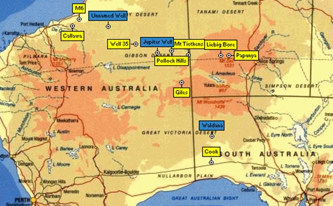
At the beginning of July 1961, Bob Bobroff was getting his party organised in Alice Springs to recce, mark and observe a traverse in Western Australia from Mount Tietkens to the Canning Stock Route in the vicinity of Well 35 as part of the geodetic survey of Australia. I joined his party at this stage having delivered a new vehicle from Melbourne. Bobroff was critical of the short time I had taken for the journey until I explained that I had driven heavy trucks for many years and enjoyed travelling at night. I heard no more about the subject.
On the evening of Sunday, 2 July our party of ten men in five vehicles left Alice Springs and travelled via Papunya and Liebig Bore to our starting point, the journey of some 350 miles (all distances noted herein are in pre-metric units) taking four days. Liebig Bore was of interest as it was our last source of water and we subsequently had to cart it from there to all points west.
The 'road' that we travelled after leaving the vicinity of Liebig Bore was put in by Len Beadell's “Gunbarrel Road Construction Party” of the Weapons Research Establishment (WRE) as part of their rocket range recovery system. It was graded along a route which National Mapping had indicated would provide a good traverse for the geodetic survey. The surface was very basic, being a single pass with a bulldozer blade followed by similar treatment with an angled grader blade which moved most of the debris off to one side of the resultant track. Travelling was generally slow and rough due to the residual Spinifex roots and ant beds forming hard lumps in the otherwise soft, sandy ground.
In the International 1 ton trucks which comprised some of our fleet, low range second gear was the normal selection, all day, every day. Other vehicles were Land Rovers, series I & II and a 3 ton RL Bedford supply truck.
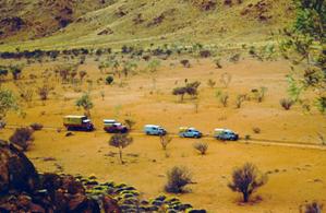
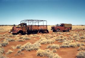
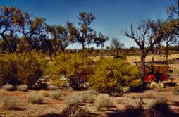
Vehicle convoy ”Burnt out” WRE Commer
At the finish of their 1960 season Beadell's party had pushed the track west more than 60 miles beyond Pollock Hills but then suffered a catastrophic gearbox failure in their grader. They then set out to (successfully) tow the grader to Giles weather station with the bulldozer. However, on the way, near Mt Webb, their Commer ration truck caught fire and was burnt out. It was to be 1962 before there were any further road works in the area.
It was there at the end of the bulldozed track, that some of our party gathered around the middle of August 1961. This area was an extensive desert oak (Casuarina decaisneana) forest and attractive at any time, but after working in the sandridges it was Utopian despite every fly in the desert holidaying there and a great deal of nocturnal scorpion activity.
At this stage I was acting as offsider for surveyor Bill Witzand and we arrived at the head of the track on Wednesday, 16 August to find Bob Bobroff there with his assistant Bob Goldsworthy and H.A. (Bill) Johnson, then supervising Surveyor of the Geodetic Section who was on an inspection tour.
The two Bobs and some others had dug a shaft at the campsite to a depth of about 10 feet and had run into solid rock. The work was spasmodic, and because of the hard going the bottom of the shaft had narrowed. Trying to cut out the rock with a crow bar was hazardous indeed as there was a good chance of driving the crow bar into one's foot.
That same day, Johnson, Bobroff and Goldsworthy set off on a reconnaissance to establish the track through to the Canning Stock Route travelling in Bobroff's Landrover LWB series 1, and Johnson's International LWB AB120.
The best route to avoid unnecessary sandridge crossings was marked up on a photo-mosaic map sheet and the only uncertainty was the position of Well 35 which had been pre-marked in the Melbourne office. The position subsequently proved to be accurate and the whole journey went very well indeed. They were, most likely, the first to visit that section of the Canning Stock Route by motor vehicle. Bobroff used an aviation directional gyro on this journey and his track was straight indeed. He complained bitterly that ‘H.A’, in dodging around rough spots was “all over the place like a water skier”.
I was left with instructions to continue work on the existing shaft. The night of the 16&17th was typical of that time of the year, but memorable because of the low temperature, a literally freezing windless night followed by a glorious sunny day. Bill decided on the morning of the 17th that it might be a good idea to look for water sites so we walked quite a distance around the area but found nothing. However, we did see some aboriginal tracks and small diggings. This was of no great note as we had had meetings with several groups of nomadic people during the preceding month. So during Friday 18/8 and Saturday 19/8 I did more work in the shaft and on Sunday 20/8 Bill left for Alice Springs and Melbourne.
I was temporarily alone and under those circumstances, I was unhappy about working in the shaft at all, due to the hazardous nature of the operation while wearing soft boots. So I decided to go for a wander around, the reasoning being that, as we were looking for a water table it might be advantageous to find a lower start point. Eventually I found a spot on about 190 degrees magnetic and about three hundred yards from the end of the track on a Ti-tree flat which seemed to be the lowest point in the immediate area.
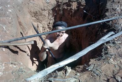
The ground was damp just below the surface and it looked a much better prospect than the other site which was bone dry, so I concentrated on digging a small hole, going for depth. It was about two and a half feet square and about as deep and I dug down with a spade another couple of feet in one corner to find increasing dampness; it looked very promising indeed.
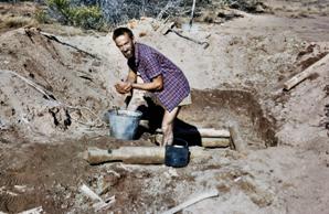
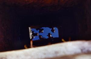
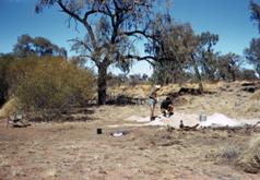
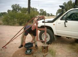
Ed Burke working on the well Reflection from the water in the well
The following day, Monday 21/8, the party arrived back from the Canning Stock Route. Bobroff was not particularly happy with the fact that I hadn't done much with the original shaft, but was enthusiastic about the prospects for the new one declaring that the area was not unlike that in which Well 35 was situated. We did some work on the new shaft that evening.
On Tuesday 22/8, we were joined by several other members of the party and set to cutting timber to shore up the shaft and taking it in turns to work at the digging and hauling the buckets of soil to the surface. We had to timber up as we dug as some of the ground was quite unstable, but we were into water!
There was a lot of discussion around the campfire that evening about a name for the place. Moonlight Well was proffered as the moon was about three quarters and quite bright. Also the name Pintubi Well was bandied around as we believed that to be the name of the local aborigines.
About 11pm, overcome with curiosity, we went to see how much water our new well had made. There, reflected in the bottom, was the planet Jupiter. So there was no doubt about it, “Jupiter Well” it was, from that moment. Had we looked down the well at a slightly different time it may have become Saturn Well as the two planets were keeping very close company.
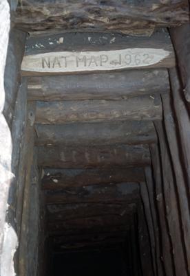
Wednesday, 23 August, we spent finishing the well and timbering around the top. We dug to a total depth of about 13 feet before water ingress and weak walls beat us, so we left it at that. The majority of the timbering was concentrated from about two feet above ground level to about two feet below ground level. The two feet protruding was backfilled to provide an elevated platform which precluded the intrusion of surface water. The opening was covered with plywood and a half 44 gallon drum fastened to it so that a drum pump could be screwed in and used for pumping water and the well was secured from the pollution of drowned wild life. There was also a small trap door so that water could be bucketed out.
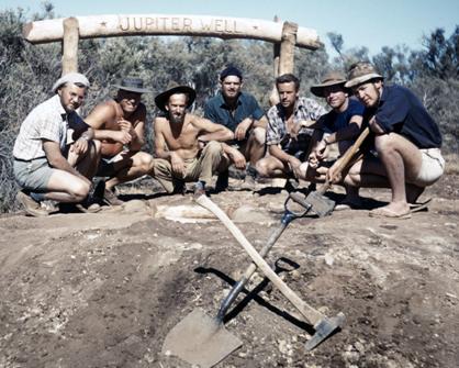
Bobroff, Boss, Burke, Goldsworthy, James, Hutton, Combe, Jupiter Well, 1961
By Thursday the water in the well had settled and was clear. It was brackish but was certainly better than nothing. We finished the work and had an immense bathing and laundry session. A group of aborigines had dropped by to see what all the fuss was about and they became included in the lunatic 'white fella' fun of squirting and bucketing each other. It was great to have water out there!
The fact that the water was not ideal drinking was a minor point. It was reckoned that in transporting water from Liebig Bore, a round trip of over 600 miles, it was costing us almost one gallon of petrol for each gallon of water. Eventually we had access to Well 35 but we found that water to be foul with rotting carcasses. Although we emptied and cleaned it as best we could, there was always the necessity of boiling that water, albeit water of otherwise good quality.
From the photo-maps, we reckoned the position of Jupiter Well to be 22º55’ South by 126º33’ East. The actual position (datum GPS AGD84) is 22º52’38.0”S by 126º35’55.4”E.
After a photo session on Friday 25/8, we left the area to press on with the survey work.
Our party eventually returned to Alice Springs on October 11. During that whole period the only occasion we saw other white people was on August 1 when a Department of the Interior survey party doing rapid levelling went by us and disappeared over the horizon in a metaphorical cloud of dust! It made us feel quite pedestrian.
Those engaged on the work were Bob Bobroff, who also chiselled the name on a large log which was erected over the well: Bob Goldsworthy, Jim Combe, Bob James, Dave Hutton, Len Boss (WRE) and I.
Forty five years were to pass before I was next in the area. In 2006, together with several groups of friends, my wife Nicole and I travelled the Desert Road on a trip which took us eventually to the Pilbara.
I was eager to see the place which I remembered so well. It was totally unrecognizable! A series of good seasons had produced a tremendous amount of understory and, combined with the effects of previous fires which had caused a great number of trees to vanish, the placed had changed drastically.
Initially I could not find the site of our well and it was only when one of the party noticed a small plaque from a 1985 visit by one Phillip Nitschke that I was able to associate the overgrown depression with the original well.
Guesswork follows :- When the current magnificent road was constructed to service the various aboriginal communities that now exist, the road construction team camped at the well. There is a scattering of old “44s” as their witness. Further they must have had difficulty obtaining water so bulldozed the well site down to the water table. Rumour has it that the well was burnt out and had collapsed.
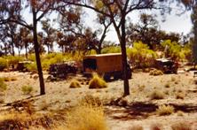
Camp site 1961 2006 2009 (note identifiable trees)
1961 camp site (note same trees in background) and “abandoned” trial well (Bobroff & Goldsworthy), 1961
(note distinctive curved branch in tree can be seen in photo above, left hand edge)
Dr Philip Nitschke's plaque was found attached to a bush by a single screw, the original post having corroded away. Nitschke had camped near the well on his own for a month and did the digging to get some useful exercise. He saw nobody else during that period and, apart from a drive through visit in '86 on his way to Well 33, has not been back there. He said that in '85 the well had largely collapsed but there was no indication of any recent fire.
Finding our 1961 campsite was accomplished by wandering the countryside armed with photos of that period trying to recognize trees. The changes made it a difficult task but a couple of old desert oak “friends” put us onto the right spot where we were able to identify the site of the original well digging (we had back filled it in 61) by the rock fragments lying around, something quite foreign to that sandy area.
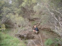
Ed Burke at modern bore vicinity Jupiter Well, and at “bulldozed” 1961 Jupiter Well site.
While every traveller in that desert knows of Len Beadell’s road team, few have any idea of National Mapping’s work, apart from the name on the maps that they often use. It therefore seemed timely to record the Jupiter Well story. How and why it was dug and why the current nearby bore and hand pump bears that name and importantly has good water.
So the return to monument the site was three years in the planning and I owe a debt of gratitude to Tom Cox, an old Melbournian friend, who was there with us in 2006 and did plenty of urging to return and finalise the job. He helped again in 2009; thanks Tom.
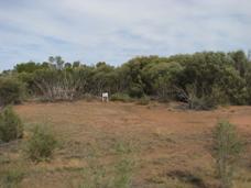
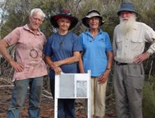
Plaques erected in 2009 at site of 1961 Jupiter Well which is to the immediate right of the sign and densely overgrown - Ed, Nicole, Ann and Tom at site - plaque erected near 1961 Natmap camp site
August 2009
......and the other “National Mapping wells” …..
As an adjunct to Ed’s story, in 1962 National Mapping’s Survey Parties dug a further well in WA and reconditioned a “native” well in SA. Both are documented in Reg Ford’s June 1979 report "“The Division of National Mapping’s part in the Geodetic Survey of Australia, Activities Based on the Melbourne Office, 1951 – 1969”".
Waldana, a native well, north of Cook, SA, was cleared out, timbered and made usable to help solve the survey parties’ water problem in the Great Victoria Desert.
Waldana, reconditioned “native” well, SA, 1962 and John Allen digging the “John Allen Shaft”, Great Sandy Desert, 1962
During work on the Callawa to Well 35 Traverse, in the Great Sandy Desert, a well was dug at the 164 mile point from M6 (211 miles from Callawa). M6 was a WA Lands Department survey point, on the telephone line north of Callawa Homestead.
The well was deepened each time the supply vehicle passed as the digging was difficult owing to limestone and there weren't any spare personnel to leave as a digging party.
Eventually very brackish water was struck at about 10 to 12 feet, the breakthrough only coming after a bit of a nudge with gelignite.
The well was never named but its “documentary rediscovery” was assisted by John Allen (who was also photographed working on it) and is hence known in correspondence as the “John Allen Shaft”!
Editor
Photographs courtesy: Ed Burke collection & Tom Cox
HA Johnson collection
OJ Bobroff collection
John Allen collection
Jim Combe
RW Goldsworthy collection through Denyse Goldsworthy
WORDING ON PLAQUES AT JUPITER WELL IS AS FOLLOWS
Nitschke, 1985
JUPITER WELL
RE-DUG OCTOBER 85
NEXT WATER :
KIWIRRKURRA
147KM EAST
WELL 35
206KM WEST
PHILIP NITSCHKE
Burke, 2009
JUPITER WELL
THIS IS THE SITE OF THE ORIGINAL JUPITER WELL
DUG FROM THE 20TH TO 24TH AUGUST 1961 BY A
DIVISION OF NATIONAL MAPPNG SURVEY TEAM
SURVEYING FOR MONTHS IN THE DESERT AND
NEEDING TO AVOID TRUCKING WATER 480KM
FROM NEAR MT LIEBIG NT
IT WAS NAMED AFTER THE PLANET REFLECTED IN
THE WELL LATE ON THE NIGHT OF THE 22ND
BULLDOZING HAS DRASTICALLY CHANGED THE SITE
NATIONAL MAPPING PERSONNEL INVOLVED WERE :-
O.J. (BOB) BOBROFF SURVEYOR IN CHARGE
BOB GOLDSWORTHY
JIM COMBE
DAVE HUTTON
BOB JAMES
ED BURKE
FROM THE WEAPONS RESEARCH ESTABLISHMENT :-
LEN BOSS
THEIR CAMPSITE IS MARKED SOME 300M NORTH OF HERE
AT S 22º 52´ 28.2" E 126º 35´ 57.0"
PLACED BY ED BURKE FOR HIS MATES - MAY 2009
Burke, 2009
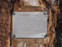
NATMAP CAMP
FROM 20TH TO 24TH AUGUST 1961
A DIVISION OF NATIONAL MAPPNG
SURVEY TEAM CAMPED HERE WHILE
THEY DUG JUPITER WELL
AT S 22º 52´ 38.0" E 126º 35´ 55.4"
SOME 300M TO THE SOUTH
A TRIAL WELL WAS DUG 15M BEHIND
YOU - NOTE THE ROCK FRAGMENTS
PLACED BY ED BURKE NATMAP MAY 2009
Geographic locations of wells and other places mentioned