Wild Heerbrugg BC-4 Ballistic Camera and Doppler/GPS TRANET Site,
Smithfield, South Australia
Around 30 kilometres to the north of the Adelaide CBD is the town of Smithfield. A large expanse of the land to the town’s west and south was originally controlled by the Department of Supply for various activities including the Weapons Research Establishment (WRE). As shown in the section of the 1949 aerial photograph below, the area west of the town of Smithfield was occupied by wartime ammunition works and storage. Over time the land was cleared of its structures but a few examples remain even today. For around 35 years, one of the old buildings of the ammunition works was pressed into service and adjacent land had survey marks established and connected to the Australian primary geodetic network. The insert in the 1949 aerial photograph below shows the northern extent of the Smithfield site as discussed below with the building in red adjacent to the later established Johns Hopkins University plaque.
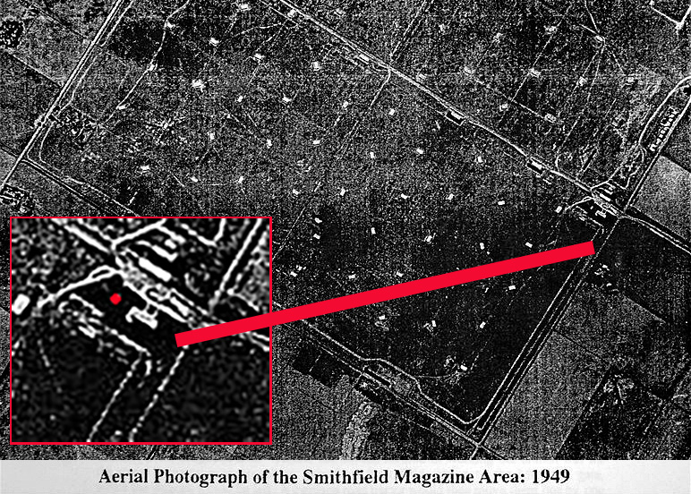
Section of a 1949 aerial photograph showing the area west of the town of Smithfield with its ammunition works and storage.
The insert shows the northern extent of the Smithfield site with the building in red adjacent to the later established Johns Hopkins University plaque.
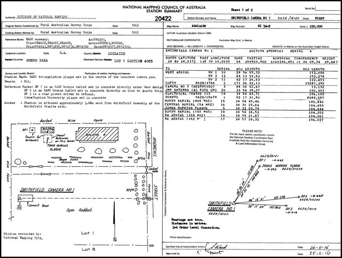
In August 1962 the Royal Australian Survey Corps (RASC) established two survey marks for positioning a Wild BC-4 Ballistic camera, Smithfield Camera 1 and Smithfield Camera 2. The mark indicating Smithfield Camera 2, some 13 metres to the east of point 1, also established in 1962, was later destroyed. Their Reference Point 1 was also established and indicated by a RASC plaque. These survey marks were all within the Department of Supply perimeter and in 1962 were still relatively accessible to transport and power but clear of urban light pollution at night for photographic operations. The position of the already established survey mark indicated by a Johns Hopkins University plaque was fixed by angle and distance from the point Smithfield Camera 1.
The Wild Heerbrugg BC-4 Ballistic camera, as originally designed, used the base of the Wild T-4 theodolite to which was fitted a modified Wild RC-5 aerial camera. The camera’s lens had a 305 millimetre focal length and was able to capture a 33° x 33° field of view on 215 x 190 x 6 millimetre glass plates. Stars to 8th magnitude could be recorded. Over time the BC-4 camera was modified to use lens’ of different focal length, roll film and automated operation.
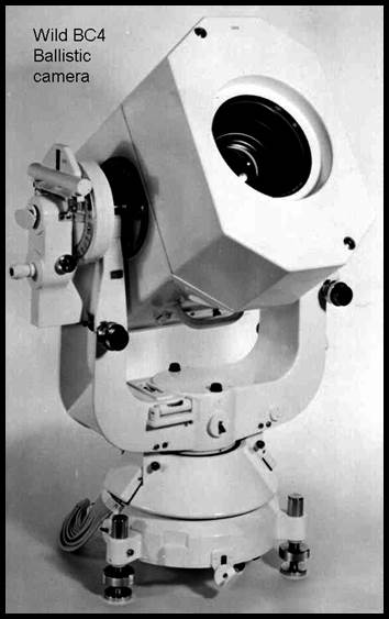
Wild BC-4 Ballistic camera with mount suitable for Wild T-4 theodolite tripod.
(courtesy Wild, Heerbrugg)
Ford (1979) reported in The Division of National Mapping's part in the Geodetic Survey of Australia, that in November 1965 a Natmap field party connected the BC-4 camera site(s) at Smithfield to the primary geodetic survey. From the primary network stations on Mount Lofty and at Quartz Hill to the east of Smithfield, the triangle was observed by Bob Goldsworthy at a camera site, Ed Burke on Mount Lofty and John Harris at Quartz Hill. Wild T-3 theodolites and MRA-2 Tellurometers were used for the angle and distance observations. It would appear that the 1965 survey provided confirmation of the original site coordinates earlier derived from a two leg Tellurometer traverse from the primary network station North Road some 30 kilometres to the north of the Smithfield site.
The selection of this site and establishment of the survey ground marks emerged from successive co-operative agreements between Australia and the United States of America. Under the earliest of these agreements co-operative development of the US Navy Navigation Satellite System TRANSIT (a name not an acronym) began. The Doppler TRANSIT system required TRANET (TRAcking NETwork) ground stations. The original six stations in the TRANET network were deployed in 1959, expanding by 1967 to some thirteen stations including Smithfield instituted in 1961. Ultimately some 20 TRANET stations operated worldwide by 1984. All TRANET stations then communicated with the control centre at the Applied Physics Laboratory (APL), of the Johns Hopkins University, Howard County, Maryland, by means of a teletypewriter communication network. The system was operated for the Satellite Geophysics Project of the US Naval Air Systems Command and was a primary source of data for research in both dynamical geodesy and the determination of the location of points on the surface of the earth. From the user’s perspective it was the precise satellite ephemerides which were computed using the TRANET station’s data which allowed the accuracy of portable Doppler receiver observations to be achieved.
The Applied Physics Laboratory (APL) of the Johns Hopkins University had in July 1957, established a space exploration study group to look into ways of applying the Laboratory's technical expertise to the field of space research. Following the October 1957 launch of Sputnik, APL researchers William H Guier and George C Weiffenbach established its orbital parameters. For propaganda purposes, the Soviets had Sputnik broadcast an unbroken tone at 20MHz. From the Doppler shift in the frequency of that simple signal a complete description of Sputnik’s orbit was inferred. It was later realised, that if the process was reversed and the position of the satellite was known, then the position of the ground station could be found. This capability was just what the Americans were seeking; satellite positioning would thus emerge and evolve into today’s GPS. The Johns Hopkins University Applied Physics Laboratory thus played a central role in the in the development of the TRANSIT Doppler positioning system. The Johns Hopkins University Applied Physics Laboratory is today a not-for-profit university-affiliated research centre (UARC). APL is a scientific and engineering research and development division, rather than an academic division, of Johns Hopkins University.
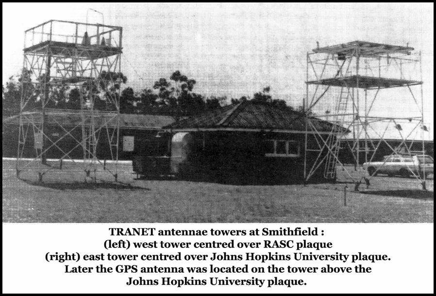
Towers at Smithfield for TRANET and later GPS antennae adjacent to equipment building.
The USA Navy Navigation Satellite System (NNSS) program commenced in 1958. The NNSS, later called NAVSAT, program’s first satellite TRANSIT-1A failed, satellite TRANSIT-1B was thus the first TRANSIT satellite to achieve orbit. A series of TRANSIT satellites followed with varying success; 2A, 2B (never built), 3A, 3B, 4A, 4B, 5A-1, 5A-2, 5A-3, 5C-1. TRANSIT 5BN-2 was launched on 5 December 1963 and became the first operational navigation satellite. It was used regularly by both surface and submarine units of the US Navy until November 1964. An unbroken series of satellites, whose primary purpose was for satellite positioning, then followed.
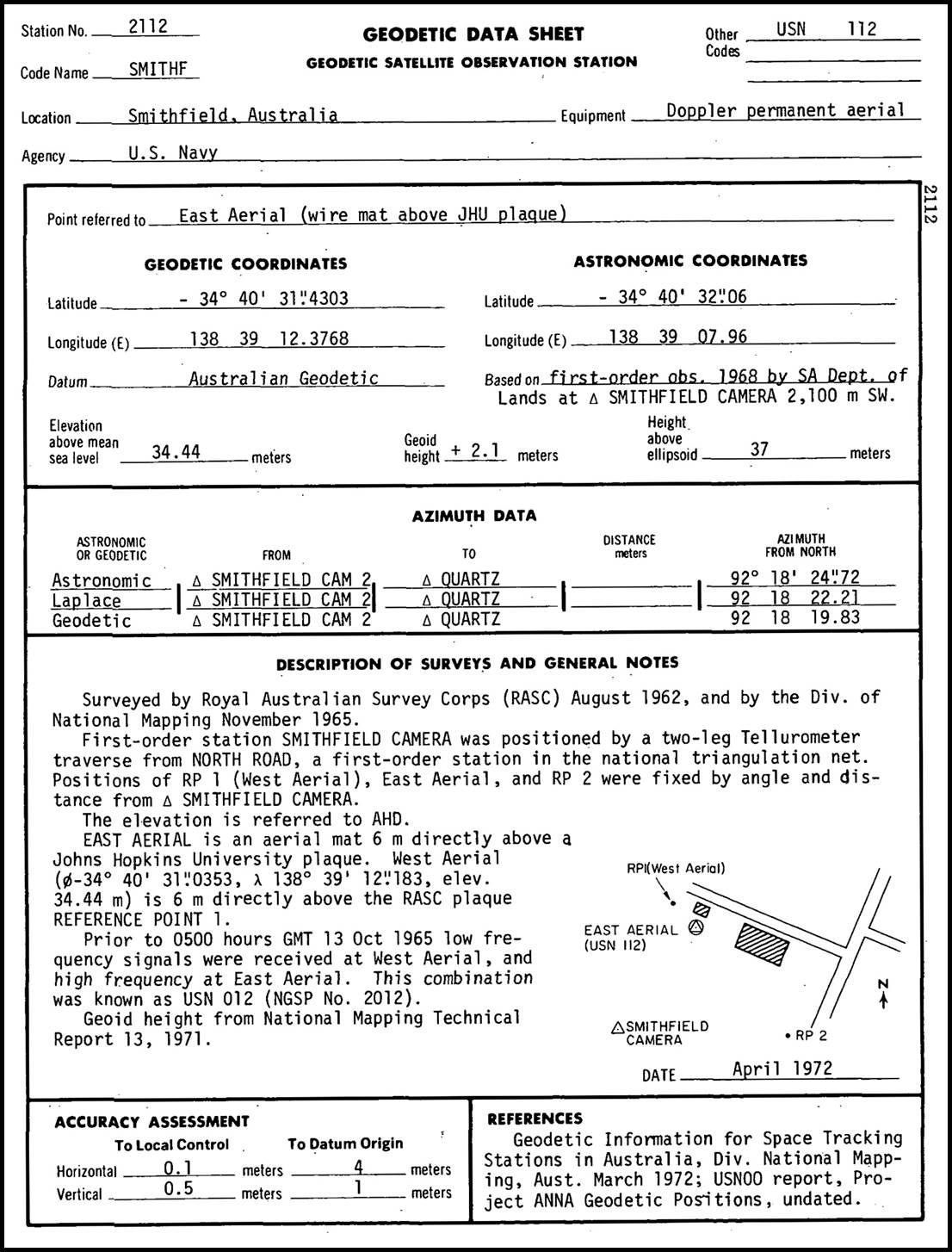
At the Smithfield site prior to 0500 hours GMT (today UT) on 13 October 1965, the low frequency 150MHz TRANSIT Doppler signals were received at the West Aerial, and high frequency 400MHz Doppler signals at the East Aerial. The East Aerial was mounted on a platform some 6 metres high such that the aerial itself was directly above the Johns Hopkins University plaque. The West Aerial was mounted on a similar platform such that it was directly above Reference Point 1 indicated by the RASC plaque (from their elevated positions the antennae had an unobstructed horizon out to around 10 kilometres for signal reception). Please refer to the photograph above and diagrams below showing the locations of these points. The received information was fed into equipment housed in the nearby old ammunition works building. After October 1965 it appears that all the antennae were consolidated onto the platform above the Johns Hopkins University plaque. The low frequency satellite signal was now received by an antenna on the southern corner of the platform. The high frequency by an antenna on the opposite northern corner of the platform. Three additional frequencies, 324MHz, 162MHz and 54MHz emitted by the TRANSIT satellites were only received by the TRANET stations. At Smithfield these signals were received by antennae on the western and eastern corners and centre of the platform respectively. The centre antenna was just 27 millimetres from the centre of the Johns Hopkins University plaque. Typically the frequency pairs 150/400- and 162/324-MHz allowed correction for ionospheric refraction effects, measuring the Doppler shift on the refraction corrected signal and reception of timing signals at the TRANET station. By having the paired antennae for both the 162/324- and 150/400-MHz frequencies (plus the 54MHz antenna in case of a failure of one of the other frequencies) located in close proximity, a common set of station coordinates could be used for both frequency pairs.
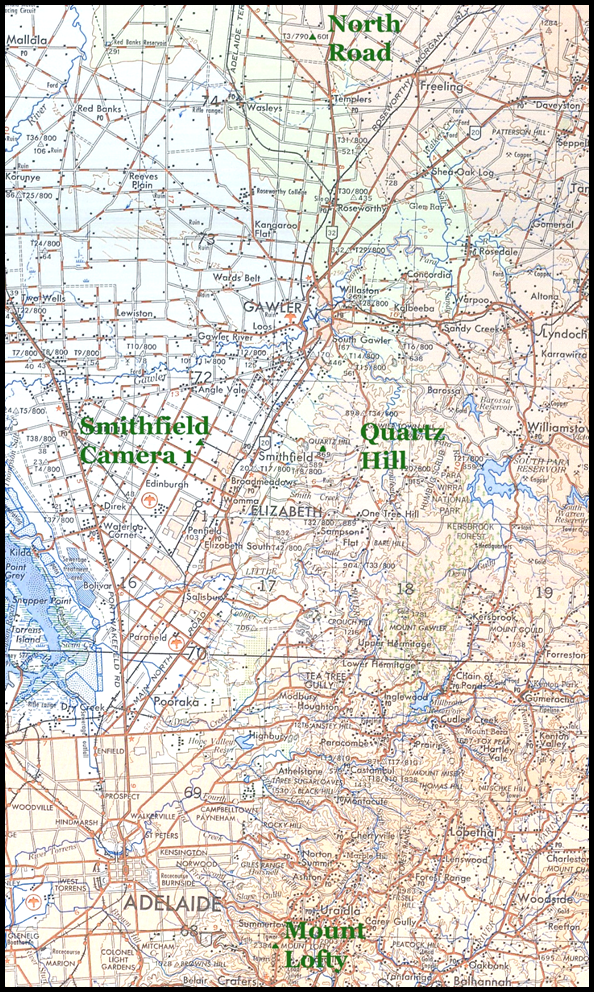
Section of 1968, SI54-09 Adelaide R502 series map, at 1: 250 000 scale showing the locations of the geodetic network stations and the Smithfield site.
In 1981, Smithfield was approved to house semi-portable tracking equipment to assist in the field testing of the former NAVSTAR now GPS system. The GPS antenna was located on the same 6 metre tower such that it was above the Johns Hopkins University plaque and plumbed within ±5 millimetres of the plaque’s centre mark. In his article GPS arrives in Australia – 40 years ago today (11 Mar 1981), Peter Jensen provided an insight into the Smithfield TRANET site at page 4 of the Canberra Survey Corps Association Newsletter 50 of March 2021 from their website.
A coordinated survey using Doppler satellite receivers was undertaken during 1975-77. Where possible the Doppler sites were selected at junction points of the Australian primary geodetic network. A total of 106 sites were occupied of which 98 were on the mainland. At Smithfield, a JMR model Doppler receiver was located as part of the survey. The JMR’s antenna was placed over a ground mark, JMR Antenna, which consisted of an aluminium tube located some 2 metres north of the Johns Hopkins University plaque. The survey and its results were published in 1978 in National Mapping’s Technical Report 21, The Australian Doppler Satellite Survey 1975-1977, by Klaus Leppert.
Between 1990 and 1994 the Scientific Committee for Antarctic Research (SCAR) mounted several major observational GPS campaigns. Notably in 1992 the aim was to produce definitive baseline connections between rock sites in Antarctica and intercontinental ties between Gondwanaland (the ancient supercontinent that incorporated present day South America, Africa, Arabia, Madagascar, India, Australia and Antarctica) continental fragments. The project involved twelve nations in the observation of twenty-eight GPS stations in three phases for sites located in Antarctica and on the surrounding southern continents. The campaign was successful with one of the GPS stations occupied during the project being at Smithfield.
The following National Mapping Council of Australia Station Summary and Table AGD66 Coordinates of significant stations at the Smithfield Site, details the locations of the stations Smithfield (BC-4) Camera 1, Smithfield (BC-4) Camera 2 (Destroyed), Johns Hopkins (University) Plaque and JMR Antenna. Also below is the April 1972 Geodetic Data Sheet for Station 2112, Smithfield, from the 1973 National Aeronautics and Space Administration, Directory of Observation Station Locations, Volume 2, Goddard Space Flight Center Greenbelt, Maryland, Third Edition.
|
AGD66 Coordinates of significant stations at the Smithfield Site |
||
|
Station name |
Latitude (S) |
Longitude (E) |
|
34° 40' 34.2372" |
138° 39' 10.0535" |
|
|
SMITHFIELD (BC-4) CAMERA 2 (Destroyed) |
34° 40' 34.1927" |
138° 39' 10.5665" |
|
JOHNS HOPKINS (UNIVERSITY) PLAQUE |
34° 40' 31.4344" |
138° 39' 12.3882" |
|
JMR ANTENNA |
34° 40' 31.3743" |
138° 39' 12.3831" |
From 1961 until 1995, Smithfield was continuously supplying Doppler and GPS tracking data for the relevant satellite positioning programs. In 1995, the Smithfield tracking operations were moved to the Defence Science and Technology Organisation area at nearby Salisbury. What is not clear, however, is whether the Smithfield site was ever used for BC-4 camera observations.
Part of the United States’ contribution to the International Geophysical Year 1957-58, was two tracking facilities in conjunction with the Vanguard satellite program, which were established at Woomera (the generic name of Woomera is used as these systems were located at different areas of the Woomera range over time). These facilities allowed Australia to gain early and first hand expertise in space tracking. The Smithsonian Astrophysical Observatory’s (SAO) optical satellite tracking facility used a Baker-Nunn camera to photograph satellites, taking advantage of the exceptional observing conditions available in the dry desert of South Australia. The Minitrack Optical Tracking System (MOTS) was an astrographic camera which took full plate glass film photographs of satellites like Echo-1 and Echo-2 against the star background. It had a 40 inch focal length lens and used 8 inch x 10 inch photographic plates. Echo-1, launched on 12 August 1960, was a 30.48 metre diameter balloon of Mylar polyester film. Designed as a passive communications reflector for transcontinental and intercontinental telephone, radio, and television signals, it also had 107.9MHz beacon transmitters for telemetry purposes. Before it re-entered the atmosphere on 24 May 1968, Echo-1 was also used to evaluate the technical feasibility of satellite triangulation. Simultaneously the satellite was photographed from two ground stations, against the star background. These photographic images were then analysed to obtain a geometrical tie between the two ground stations. Echo-2 was launched in 1964 and burned up in the atmosphere on 7 June 1969. It is clear that neither Echo satellites were photographed using a BC-4 camera based at Smithfield.
ANNA (for Army, Navy, NASA, Air Force) was the first dedicated satellite for geodesy. It featured Xenon flashing lights and radio transponders (SECOR - Sequential Collation of Ranges) for tracking the satellite. Johns Hopkins University, Applied Physics Laboratory was the prime contractor. By pinpointing the satellite’s position, precise geodetic calculations could be made. Later the SECOR transponders were flown on dedicated SECOR satellites. ANNA was launched on 10 May 1962 but failed to reach orbit. A second ANNA was successfully orbited on 31 October 1962 (the second ANNA was thus designated ANNA 1-B, with the original ANNA redesignated ANNA 1-A). Designed for six months of operation, ANNA 1-B was productive for at least 22 months. Optical data from ANNA 1-B seems to have only been recorded in the USA.
PAGEOS was launched on 24 June 1966 and operated for nine years. PAGEOS was progressively photographed by some 45 BC-4 Ballistic cameras sited worldwide during the global cooperation Weltnetz der Satellitentriangulation (Worldwide Geometric Satellite Triangulation Program). Three BC-4 cameras were located in Australia at the extremities of the Perth (Site 032)-Culgoora (Site 060) east-west baseline and Thursday Island (Site 023)-Culgoora (Site 060) north-south baseline. From 1967 to 1970 the majority of National Mapping’s geodetic resources went into refining existing surveys to generate these two baselines. It is clear that the Smithfield BC-4 camera site was not used in the final PAGEOS observation program. Given the timing and its location however, it is not impossible that the Smithfield camera site was established as part of the initial PAGEOS program before Australia volunteered its two baselines. If so, BC-4 camera observations may have been acquired at Smithfield for initial testing and calibration purposes.
By 1972 the era of using the BC-4 Ballistic camera for optical satellite tracking had ended. The 1973 National Aeronautics and Space Administration, Directory of Observation Station Locations, Volume 2, Goddard Space Flight Center Greenbelt, Maryland, Third Edition, listed details of some sixty sites used for BC-4 Ballistic camera observations. Smithfield is not listed, seemingly confirming that the Smithfield site, if used at all for BC-4 camera observations, was not used operationally.
Compiled by Paul Wise, April 2021