From Aerial Photography to Remote Sensing - A History of Aerial
Photography and Space Imagery Acquisition in Australia
John Manning
Abstract
Aerial Photography developed as a promising
mapping technique during the First World War. The subsequent Australian
application of this technique developed in the 1920s and 1930s as aircraft came
into increasing use in remote areas.
With better aircraft performance and stable
flight ability, systematic flight lines became possible and trimetrogon
reconnaissance photography was commenced in 1942 but vertical aerial
photography had become the major tool of the topographic mapmaker by the end of
the Second World War. Extensive systematic vertical aerial photography was
flown principally by the RAAF leading to a complete coverage of the Australian
Continent.
Since the 1970s imagery from space craft has
become widely available, firstly with SKYLAB photography and a complete cloud
free Landsat data set over Australia is now commercially available.
In the 1980s, Large Format Camera photography
from the U.S. manned space shuttle flights and imagery from the French SPOT
satellites has produced analogue and digital imagery with resolutions
approaching 10 metres. Soviet space photography is also commercially available
across most of the Australian Continent.
This paper traces the development and
application of aerial photography in Australia and examines the current trends
of space imagery for mapping purposes.
Historical Background
The first
reference to the application of photography in making topographic maps probably
was in 1840, when Dominique Francois Jean Arage, the French geodesist, appeared
before the Chamber of Deputies in Paris, and advocated the use of the
daguerreotype photographic process for topographic mapping. In 1849, Aime
Laussedat, an officer in the Engineer Corps of the French Army, sought to prove
that photography could be used with advantage in the preparation of military
topographic maps. Much of his work was with terrestrial photography from a
phototheodolite. In 1858 Laussedat experimented with a glass plate camera in
the air, first supported by a string of kites and later by a
"captive" balloon. Laussedat also made a few maps of Paris with the
aid of balloon photography; converting overlapping perspective photographs into
orthographic projections (Graham and Read, 1986).
About 1900,
Captain Theodor Scheimpflug of the Austrian Army, provided a solution for a
problem in aerial photography that was a stumbling block to Laussedat - How to
obtain complete coverage of the area visible from a camera station in the air?
Scheimpflug
used an eight-lens camera attached to the basket of a balloon. This camera
consisted of seven oblique lenses grouped around a central vertical lens, thus
producing one vertical and seven oblique views that could be transformed into
an extremely wide-angle single composite photograph. Scheimpflug conceived the
representation of whole tracts of terrain in the form of photomaps composed of
aerial photographs. He encountered problems with the positioning and
orientation of his cameras and saw the advantages of taking photographs from
planned positions such as moored dirigibles.
With the
invention of the aeroplane in 1903, aerial photography took on a new and more
important meaning to the map maker. In 1909 the first recorded photographs were
taken from an aircraft whilst Wilbur Wright was giving exhibition flights in
Italy. In 1913 the Watson Air Camera was designed specifically for aerial photography
in the British Royal Flying Corps (RFC). It was flown initially in the
dirigible airship "Beta" but the camera was virtually destroyed a
year later in a heavy aircraft landing when "the aeroplane crumpled into
an unrecognisable heap of wood, wire and fabric" (Lamboit, 1985).
World War I
When World
War I was declared an Experimental Flight was established by the RFC and in
September 1914 the first hand held photographs over enemy positions were taken
at the Battle of the Aisne. Soon after the Type 'A' camera was produced by the
Thornton-Pickard Company. This employed 5" x 4" plates and an 8 inch
Zeiss Tessar Lens. It was first used over enemy trenches on 2 March 1915
(Lamboit, 1985). In 1915 Oscar Messter also built the first specialised German
aerial camera.
At a meeting
of the Royal Photographic Society in 1919, the Chief of the British Air Staff,
General Sykes, gave some details of the progress made in photography from
aeroplanes and other devices during World War 1. He had gone to the Dardanelles in 1915 and found that when aerial
photography was started there:
"It was discovered bit by bit that the
maps upon which they were relying were absolutely inaccurate. They then set to
work to make new maps, entirely from aerial photographs."
With regard
to the war in France he summarised the growth in aerial photography acquisition
in that period:
"Between January and August 1916, the
number of different photographs taken was 87,000 and between the same period in
1918 the number totalled 827,000" (Australasian Photo Review 1919.)
Germany also
had used more than 200 of Oscar Messter's excellent mapping cameras to record
more than 7 million square kilometres in the form of strip-mosaics before the
war ended, and by 1919 these cameras were mapping the entire Western Front
every two weeks (Graham and Read, 1986).
At the end of
the war no fewer than 400 different camera designs were employed on the British
front; 4,000 cameras were in use in the field and a further 5,000 cameras of
all types for training in England, although not all were aerial cameras (Parry,
1982).
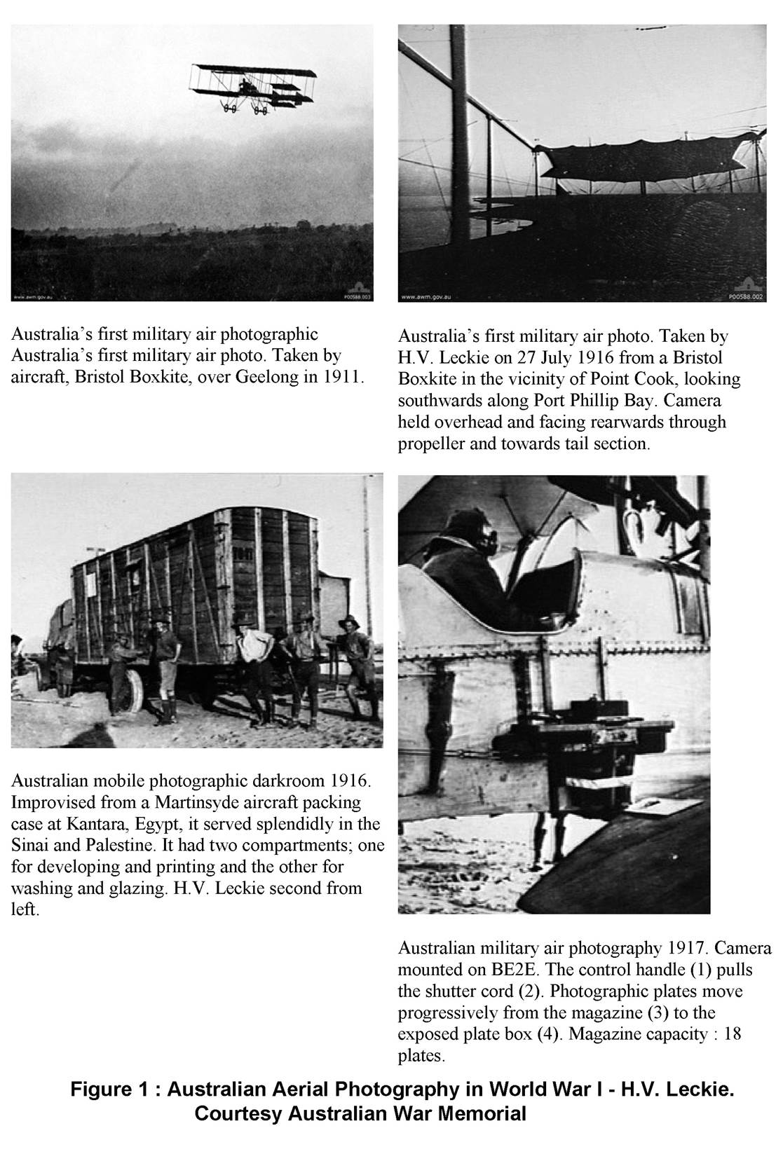
Australian Aerial Photography in World War
I
Photography
from an aeroplane appears to have been non existent in Australia at the
outbreak of World War I. As soon as the Australian No. 1 Squadron arrived in
Egypt, it was realised that photography was an essential function of Flying
Corps activities, and an urgent cable was dispatched to Australia for
photographers to be included in the first reinforcements due to sail from
Melbourne on 25 July 1916.
An
advertisement was placed in the Melbourne "Argus" on Saturday 12 July
1916 for three photographers to serve overseas with the Australian Flying
Corps. One of the photographers chosen, Harry Leckie, recalls their training at
Point Cook:
"We all then had to make our first
flight. Those who drew the Depussier had the Observers Cockpit to sit in while
with the Bristol, a kerosene case was nailed behind the Pilot and in front of
the propeller at the rear, with nothing within reach to hold on to. I was the
only one of our three to go up in the Bristol and to take my camera up with me,
and thus became the first accredited Photographer in the Air Force to take
photos from an aeroplane in Australia. The negatives I still have were secured
by holding the camera over my head and shooting past the tail plane and along
the shores of Port Phillip Bay" (Leckie 1973).
The
Australian Flying Corps photography unit in the Middle East was known as the 67
Squadron and was attached to the 5th Wing Royal Flying Corps. Its photographs
were used extensively in hostilities across the Sinai Desert and Palestine. The
first mosaics to show desert trench positions were produced from glass
negatives with flight lines flown only half a mile apart. In Palestine the
whole of the mapping work was undertaken from aerial photographs and Leckie
comments on their success:
"We were rather pleased after the
first Gaza Battle and the many skirmishes that led up to it, when the Squadron
was paraded at Kilo 143 Drome before Major General Salmond who singled out our
Photographic Section - for their magnificent work in turning out such fine
photography under extraordinarily difficult conditions across the desert, and
thus greatly facilitating the planning of the Light Horse attacks" (Leckie
1973).
In later
years Brigadier Fitzgerald (1962) noted that during the campaign in France a
Topographical Section of the Australian Corps, had also been responsible for
all tactical maps needed by the Australian Division. These maps were based on a
French 1:20 000 series supplemented and amended with trench detail from aerial
photography taken by the Australian Flying Corps.
The valuable
but elementary application of aerial photography to mapping during the First
World War indicated its great potential for civilian topographic mapping.
Early Airborne Photography in Australia
After World
War I the first records of aerial photographs taken in Australia indicated that
general purpose photos were taken with the camera held over the side of the
aeroplane. In 1922 a Vickers flying boat had been employed in Tasmania to carry
out aerial mapping work and in the same year J. King made an aerial
photographic survey of Launceston for the City Council at the cost of 80 pounds
(Copley, 1976).
The first
Commonwealth vertical aerial photography of defined areas for mapping purposes
was taken on an experimental basis by the Royal Australian Air Force (RAAF) in
1924. The areas were Western Port Bay in Victoria and Wisemans Ferry in NSW and
the photographs were taken with a P18 plate camera with a 4" x 5"
format. They were not covered with regular overlapping runs but were a series
of individual photos which overlapped each other to varying degrees and the
results were not successful for mapping (Fitzgerald, 1962).
More
successful however was the co-operative project between the RAAF and the Royal
Australian Naval Surveying Service. This project used experimental aerial
photography for charting the Cumberland Channel of the Great Barrier Reef in
1926. The 1,250 tonne HMAS GERANIUM was specially fitted to carry a Fairey III
D seaplane on her quarter deck. Vertical aerial photographs were mosaiced to
show reef outcrops for assistance in detailed depth sounding.
Following
World War 1 the British War Office recognised the significance of aerial
photography and the need to apply it to the best advantage. An Air Survey
Committee was created under Lieutenant Hotine. It was a report from this
committee dated June 1927 which led to the raising of a permanent RAAF Survey Flight. In that year two RAAF officers were sent to
England for instruction in the then new technique of photographing areas with
straight parallel flights; with correct lateral and side overlaps and with the
camera being maintained within a few degrees of vertical.
On the return
of these RAAF officers a start was made on systematic aerial photography in
Australia. The cameras used were the Williamson F8 series which had been
converted from a plate camera to use film. The early models had an 8-1/4"
lens but later models were fitted with 7" and 10" lenses. The
photography format was 7" x 8-1/4" of which 1-1/4" was used to
photograph an instrument panel. Each roll of film provided for 100 exposures.
The first areas were flown in the eastern
states. Flight lines were north/south with
east/west key strips. The map sheets photographed from Westland Wapiti aircraft
included Nowra, Kiama, Moss Vale, Albury, Mittagong, Saint Albans, Wallerawang
in NSW, Dugandan, Caboolture, Springbook, Tweed Heads and Warwick in
Queensland, and Melbourne and Yan Yean in Victoria. (Fitzgerald, 1962). By the
end of 1930, an area of 19,000 square miles had been flown.
While the
RAAF was active on the eastern seaboard, in the west and in remote inland
areas, private flying companies struggled to establish mail and passenger air
routes and welcomed aerial survey work. In 1927 the WA Government let a
contract to a private air survey firm for vertical stereoscopic aerial
photography to be used for contouring so that the best railway routes could be determined
through the Darling Ranges, east of Perth. Sir Norman Brearley described the
flying operations on that project:
"We started the
survey, but soon found difficulty in piloting along a series of parallel
straight courses. The monotonous bush country had very few features by which
one could navigate. One step towards overcoming this difficulty was to divide
the control of the plane between two people. In the passenger cabin was
installed a rudder control consisting of a joy-stick which moved only to left
or right. An opening cut in the front of the cabin roof allowed a
"helmsman" to stand up behind a windshield and and steer the plane.
The pilot at the rear, with his feet off the rudder bar, kept the plane level
and at a uniform height while the straight runs were made. My brother Stan was
the pilot and I was the helmsman in this new arrangement.
We also devised a method
of making parallel straight runs while we flew at a height of 8,000 feet. A
road ran almost north and south near the western side of the 400 square mile
area to be surveyed. On the road we placed a man with a car. He took up a
position at the western end of the first strip to be "shot and we took up
our position in the plane at the other end of this strip. When the ground guide
sent sun flashes from a large mirror to give us his position, we flew straight
towards him. We then flew a compass course back on the next strip, while the guide motored a measured distance along the road and
was ready to repeat the performance for our next run. The plan worked well. The
results of the survey were good, and the Chief Engineer expressed the
satisfaction of his Department and the Government" (Brearley 1971).
The
Queensland government also used chartered Qantas aircraft for aerial
photography as early as 1928 to help survey crown lands around Barcaldine for
farming subdivision.
In 1929 Dr
C.T. Madigan obtained support of the Royal Geographical Society of Australasia
for a project to carry out an aerial reconnaissance of the dry lakes of South
Australia. The RAAF lent him two of their new Westland Wapiti aircraft complete
with crews and used Williamson Eagle vertical cameras to produce aerial strip
photography. These flights culminated in long sorties over the Simpson Desert
and the MacDonnell ranges and nearly seven thousand kilometres were flown. The
photographers took hundreds of vertical and oblique photographs. Madigan, a
geologist, was pleased with the photographs of the macdonnell Ranges but
reported that there had been little of interest to photograph in the desert.
In the early
1930s the Western Mining Company began to undertake large scale gold
prospecting in Central Australia using new specially equipped DH84 Dragons for
their geological survey. One aircraft was fitted with a Williamson Eagle IV,
the most modern camera of the time.
In May 1934
the Commonwealth Government announced that a complete aerial geographical and
geophysical survey of northern Australia would be carried out by the RAAF. This
brought a reaction from the private flying companies. The magazine
"Aircraft" at the time applauded the idea but commented:
"The RAAF is ...... simply not
equipped with proper personnel or material for such an expedition ....... only established
aerial survey companies can do the job. Obviously, the only and proper way is
for the Government to call tenders among private organisations".
The survey
went ahead and up to the beginning of World War 2 many areas in northern
Australia were photographed in Avro Anson aircraft at a scale of 1:20 000 for
the project.
Aerial Photographic Coverage of Australia
As a wartime
expedient trimetrogon photography was introduced in 1942 for reconnaissance
mapping purposes along the Northern Coast and in South Australia and Western
Australia. This was discontinued and replaced when increased vertical
photography capability became available. During the war years large areas of
Australia and New Guinea were photographed for mapping projects, intelligence
and other defence purposes. The Williamson Eagle IV camera was used extensively
but in 1943 the RAAF introduced the Fairchild K17 camera with a 6", wide
angle lens and a picture format of 9"x 9".
At the end of the war,
Aerial Survey Branches were set up in Victoria and Tasmania state mapping
authorities and photography carried out by civilian agencies for these
authorities soon commenced.
In 1950 aerial
photography operations were commenced by the South Australian Department of
Lands with a test flight in a Fox Moth aircraft. The pilot, Alan Vial,
summarised the results:
"The only real failure though was the
navigator's, in that the flight lines although quite parallel, were at 7
degrees to true north, and he had forgotten to allow for the magnetic variation
in the courses which were passed to the pilot. A heinous crime in the world of
navigation, but it did not detract from the overall results, which were very
encouraging, so much so that permission was granted for the Department to call
for tenders for the supply of an aircraft to meet certain specifications".
(Vial 1959)
Robby's Aerial Services
won the subsequent aerial photograph contract with an RC5 camera installed
initially in an Avro Anson aircraft which was later replaced by a Douglas DC3
in 1957.
The 87 Squadron
From its formation
during the Second World War until disbandment in 1953, the 87 Squadron of the
Royal Australian Air Force was the main source of aerial photography
acquisition for mapping over Australia.
The No. 1 Photographic
Reconnaissance Unit (which became 87 Squadron) was formed at Laverton Victoria
on 8 June 1942. Its objectives were to carry out long range strategical and
tactical reconnaissances. Initially resourced with Brewster Buffalo aircraft
and Williamson F24 cameras the Squadron moved to North West Australia in August
and commenced operations in September 1942.
The Buffalo aircraft
were not suited to offshore operations and were used on the photographic survey
of local aerodrome sites as well as work requested by RASVY. Due to accidents,
enemy action, and an aircraft destroyed in a forced landing near Derby on 25
September, only one aircraft was left serviceable. Lockheed Lightnings were
added to the Unit and on 3 November the first overseas photographic
reconnaissance of enemy held territory was flown over the Tarimbar Islands.
The Unit history
recorded constant operational problems encountered with unsuitable aircraft.
The situation did not improve until delivery of the first modified Mosquito
aircraft in June 1944. The Unit became the 87 (PR) Squadron on 10 September
1944. Vincent (1982) gives an excellent account of the operations of the 87
Squadron in his book "Mosquito Monograph". After the war 87 Squadron
was disbanded on 24 July 1946. Aircraft, men and equipment were posted to the Survey
Flight which in turn became the Survey Squadron on 1 November 1946.
By the end of
the Second World War plane tabling had been completely replaced and aerial
photography was the only tool efficiently used for topographic mapping.
RAAF aerial
photography continued in 1947 with detachments working in most states and in
March 1948 the Squadron commenced operations under the title No. 87 (Survey)
Squadron. In the period from 1 June 1947 to 18 June 1948 the Squadron was very
active and photographed 328,000 square miles of Australia with 40,000
photographs.
In 1953 the
Squadron carried out their last project, the photography of a large part of the
Great Sandy Desert, completing the Noonkanbah sheet on 29 August. The Squadron
was disbanded by the end of that year but a valuable asset in reconnaissance
photography over a million square miles of the continent had been flown, mainly
from Mosquito aircraft at scales from 1:45 000 to 1:50 000. The extent of
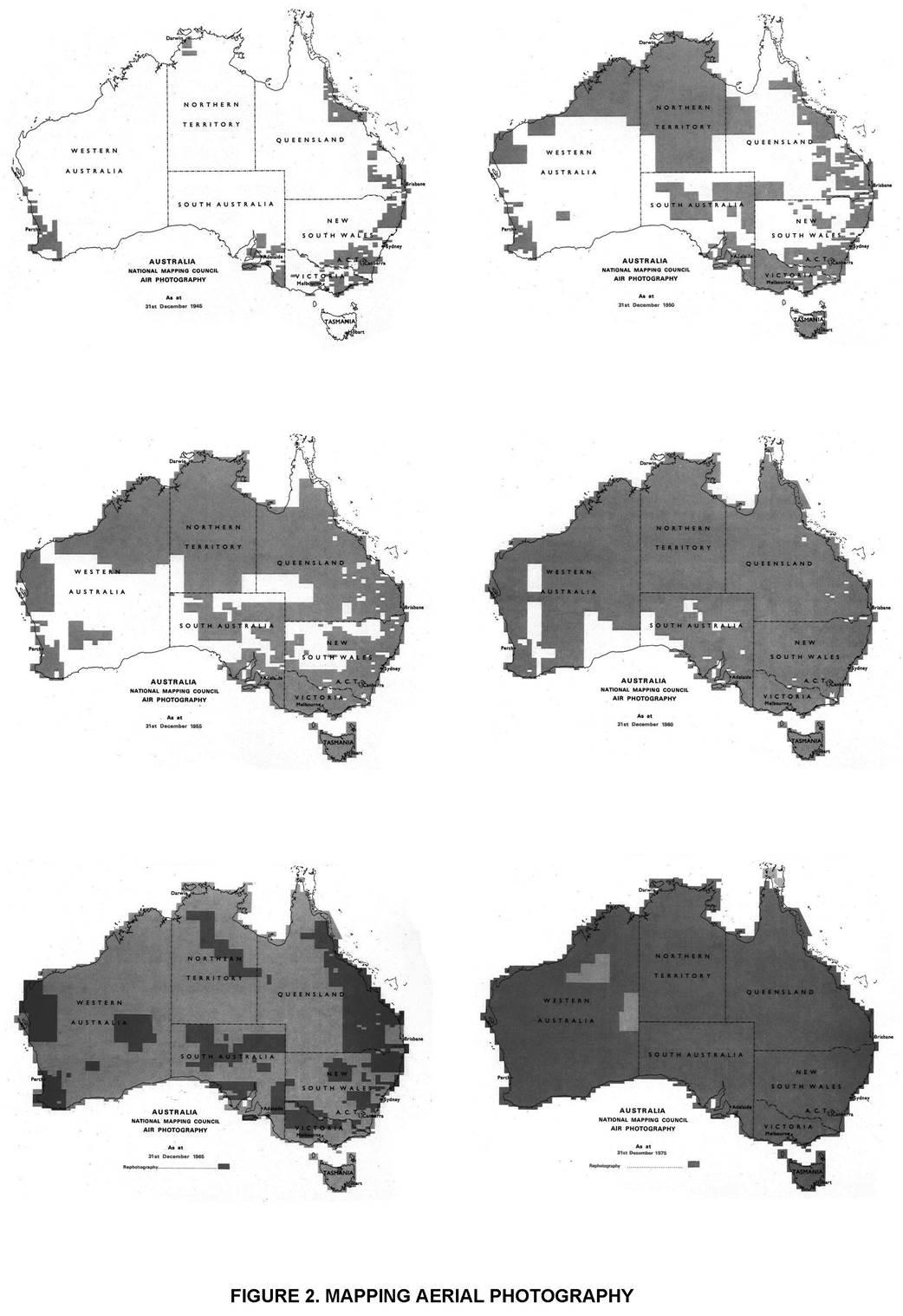
photography coverage at this time is shown in Figure 2.
|
1927
|
Survey
Flight established.
|
|
June
1942
|
No.1 Aerial
Photographic Reconnaissance Unit (PRU) established.
|
|
September 1944
|
No. 1 PRU renamed No. 87 (PR) Squadron.
|
|
July
1946
|
No. 87 (PR)
Squadron disbanded and transferred to Survey Flight.
|
|
November 1946
|
Survey Flight renamed Survey Squadron.
|
|
March
1948
|
No. 87
(Survey) Squadron established.
|
|
November
1949
|
Renamed No.
87 (PR) Squadron.
|
|
December
1953
|
No. 87 (PR)
Squadron disbanded.
|
Table 1 : Chronology of RAAF Aerial Photography Units
Post 1953 Photography
In 1953 the
RAAF sought approval for the creating of a special air survey organisation over
and above the normal RAAF establishment on the basis that its operational
expenses would be reimbursed from the money allocated for national development.
Cabinet however decided to terminate the arrangement whereby RAAF undertook
civilian mapping photography for the nation, and directed that contracts should
be let to commercial air survey firms for any aerial photography required by
Commonwealth Departments up to a limit of 120,000 pounds per annum.
With the
transfer of aerial photography for mapping to the civilian sector, the RAAF
limited its aerial photography operations to reconnaissance, surveillance and
defence requirements. In 1961 all non restricted RAAF films were transferred to the Division of National Mapping
for the sale of derivatives to public users. In 1973 however aerial photography
operations in support of the RASVY mapping activities were recommenced with
aerial photography from the high altitude Canberra bombers. Areas were flown in
Western Australia with RC10 cameras with super wide angle lenses.
The photography was
black and white at a scale of 1:138 500 from 40,000 ft. Later a number of areas
were flown in the Northern Territory at a scale of 1:80 000 from 25,000 ft before
the Canberra bombers were taken out of service in 1983. As replacement, over
the next four years, 6 Sqn RAAF crewed a leased Learjet aircraft to take 1:65
000 scale photography from 20,000 ft for mapping purposes.
The first private
Commonwealth aerial photography contracts were undertaken by Brown and Dureau
and the Adastra aerial survey companies. In 1953/54 the sum of 85,000 pounds
was spent on Commonwealth aerial photography contracts in New Guinea and
Australia. Additionally a contribution of 12,900 pounds made to the State
Mapping Authorities for photography of areas not covered by the Commonwealth
program. This subsidy was at a rate of five shillings per square mile.
The following year
similar Commonwealth contracts were let for 127,000 pounds and in 1955/56 for
113,000 pounds with additional payments each year to State authorities.
However, difficulties were encountered with the cameras and in 1955 following
adverse comment by State Authorities the National Mapping Council passed
Resolution 109:
"That this Council notes that aerial
photographic film supplied by the two private aerial survey companies to
Government agencies in some cases contains distortions beyond the limits specified
under contract and requests the Director of National Mapping to convey to these
two companies that in future a more rigorous check will be kept on these
distortions" (National Mapping Council 1955).
Commonwealth aerial
photography for the R502 1:250 000 scale topographic map series continued on a
contract basis with private sector contractors using mainly Fairchild K17
cameras until 1960 when the Division of National Mapping purchased the first
Wild RC9 super wide angle cameras. These were supplied to contractors and
standard coverage at a scale of 1:80 000 was commenced. The effect of the
coverage provided by the super wide angle lens in the RC9 camera was to reduce
the number of models per map area by approximately 75%, with similar economies
in subsequent handling but required more skillful photo interpretation of map
detail at the smaller scale. The state of the civilian industry as of 1 January
1960 is shown in Table 2.
|
|
Aircraft
|
Aerial Survey Cameras
|
|
|
Avro Anson
|
Dakota
|
Lockheed
Hudson
|
De Havilland
Beaver
|
Williamson
Eagle IX
|
Williamson
OSC
|
Fairchild K17
|
Wild RC5
|
Wild RC7
|
Wild RC8
|
Wild RC9
|
Zeiss RMK
|
|
Division of
National Mapping
|
|
|
|
|
|
|
|
|
|
|
2
|
|
|
Dept External
Affairs - Antarctic Division
|
|
1
|
|
1
|
|
|
1
|
|
|
|
1
|
|
|
Snowy
Mountains
Hydro-Electric
Authority
|
|
|
|
1
|
|
|
|
|
|
1
|
|
|
|
Department of
Lands,
New South
Wales
|
|
|
|
|
|
|
|
1
|
|
|
|
|
|
Department of
Lands & Survey, Victoria
|
|
|
|
|
|
|
|
|
1
|
|
|
|
|
Department of
Lands,
South
Australia
|
|
|
|
|
1
|
|
|
1
|
1
|
|
|
|
|
Department of
Lands & Survey, Western Australia
|
|
|
|
|
1
|
|
|
|
|
|
|
1
|
|
Adastra
Airways Pty Ltd
|
2
|
1
|
3
|
|
1
|
1
|
|
1
|
|
|
|
|
Table 2 : Aircraft and Cameras in use by Australian Civilian
Mapping
Agencies as at1 January 1960 (National Development, 1960)
By 1960 a considerable
area of Australia had been covered with aerial photography, much of it flown
immediately after the war years and in 1963 the first cover of Australia with
aerial photography had been completed, even though the photography of some areas
had been taken with cameras showing large distortions. This photography however
was becoming out of date, and in areas where intensive post war development was
taking place, was totally inadequate in satisfying the requirements of various users (National
Mapping Council, 1959). For example Lines (1962) found it necessary to use
supplementary spot photography with hand held F24 cameras to upgrade
information even for the initial compilation of R502 1:250 000 first edition
maps.
Over the next fifteen years 15 private
companies flew systematic E-W, 1:80 000 contract aerial photography over
practically all of Australia, except for small pockets in Western Australia
which were proving logistically difficult and the tip of Cape York, which had
persistent cloud coverage.
In 1976 the Division of National Mapping,
following successful American experience with high altitude jet aircraft
chartered a Lear Jet aircraft and covered the remaining desert areas with
North-South Wild RC10 photography centred over map sheets from 45,000 ft ASL at
a scale of 1:152 000. This photography was planned to enable an orthophotomap
covering an entire 1:50 000 scale map sheet to be produced from a single
photograph. Problems were encountered in resolution of the final product and with the tip and tilts resulting from the roll and pitch of the
aircraft. The short wing on the aircraft made it slow to react to flying
corrections in the thin atmosphere at that altitude.
High altitude
photography was flown in 1977 at 40,000 ft ASL (scale 1:138 500). The Lear Jet
aircraft stability improved at this altitude but single photo coverage for a
whole 1:50 000 map sheet was not attainable. Resolution and orientation again
presented problems with some photographs but Australia had now been totally
covered with aerial photography flown with metric cameras. Commonwealth aerial
photography for topographic mapping continued with a chartered Learjet at a
flying height of 25,000 ft for three more years before being replaced with a
conventional Cessna 421C aircraft.
Satellite
Imagery
The earliest
satellite images of Australia were provided by the TIROS and NIMBUS series of
weather satellites in the early 1960s. These were for meteorological purposes
and were of no consequence to the Australian cartographer.
Space Photography
In the 1970s
the situation began to change as manned satellite stations brought back film
photography from space missions.
In 1974 a
swathe of colour imagery from Cape Howe to Alice Springs was received in
Australia from NASA for evaluation of its mapping potential. This photography
was taken from the manned American Skylab III satellite in the winter of 1973
with an S190B earth terrain camera, using 5 inch Kodak S0-242 colour film.
Flying time for this run was six minutes, the scale approximately 1:945 000,
and with a focal length of 460mm, the ground cover was approximately 109 x 109
kilometres for each photograph.
The Large
Format Camera, built by Itek, was flown by NASA during shuttle mission STS-17
in October 1984. Swathes across Australia were photographed from Shark Bay to
Tasmania and along the Queensland coast. Good quality imagery with a resolution
of about 10m per line pair was achieved on a 23 x 46 cm format. It was suitable
for many applications but although both colour and black and white film were
used the lack of systematic coverage inhibited its wider utilisation. Some of
this imagery has however been used for the photogrammetric plotting of the
Great Barrier Reef (Manning, 1987), where the large area coverage, 380 km x 190
km and the sound metric accuracy available were used to advantage.
The USSR has
built up a bank of space photography from manned flights over Australia in
SALYUT and SOYUZ satellites since 1975. The Zeiss Zena MKF-6 multispectral
cameras were used in a number of these space vehicles. It consisted of a bank
of six photographic film cameras each with a separate spectral range. At flying
heights of 250 and 350 km the following parameters are applicable (Kraemer and
Szangolies, 1986).
|
Photo Scale
|
1:2 million
to 1:2.8 million
|
|
Area
Photographed
|
70 km x 160
km by 100 km x 225 km
|
|
Ground
Resolution
|
13 m to 19
m
|
Recent Russian Kate
series cameras (Kate 200, Kate 140 and KFA-1000) with larger formats have built
up the coverage of about 90% of Australia at scales of 1:1 000 000, 1:500 000
and 1:200 000 respectively. Resolution is stated as ranging from 6m to 60m.
This coverage provides high resolution imagery with stereoscopic overlap in
either multiband or panchromatic modes. Some of the photography has been
digitised and is available on Computer Compatible Tapes as raw or rectified
data at resolutions of 5, 10 or 20 lines per mm (Technical and Field Surveys,
1987).
Scanned Imagery
One of the technology
highlights of the 1970s was the series of Earth Resources Technology Satellites
(ERTS) equipped with multi-spectral scanners (MSS). This new scanning
technology showed the immense potential of a system which could produce
virtually complete world coverage every 18 days with 80 metre pixel resolution.
The first of the series, ERTS 1 (later LANDSAT 1) was launched by NASA on 25
July 1972 and MSS imagery of Australia was available that year in digital and
photographic forms and the different spectral bands could also be merged to
produce colour composites.
This imagery had a scale
of approximately 1:1 million with a ground cover of 185 x 185 km per scene.
Orbital path was sun sychronous in the morning with an inclination of nine
degrees east of north, satellite flying height was 920 kilometres. The imagery
was widely used for thematic cartography and geological exploration purposes.
In 1979 the Australian
Landsat Station, now the Australian Centre for Remote Sensing (ACRES), was
established to receive and distribute Australian imagery under license to the
USA. Full coverage of Australia was achieved in 1980 and this is still updated
every sixteen days. Currently both Landsat 4 and 5 are operational and carry
MSS and Thematic Mapper (TM) sensors. They are flown at a lower altitude of 705
km but provide similar ground coverage which is on a 16 day cycle. However,
reception of the 30 metre pixel TM imagery by ACRES has only been available in
Australia on a limited basis using equipment developed by CSIRO and the
Australian Mineral Industries Research Association.
In 1987/88 the Commonwealth
Government approved a A$14 million upgrade of ACRES to enable the direct
reception and processing of Landsat TM and the French SPOT satellite data (Gray
et al, 1987). The Landsat program will continue into the 1990s under the
operational control of the Earth Observation Satellite Company (EOSAT) and Landsat
6 is due for launch in 1991. In addition to an Enhanced Thematic Mapper (ETM)
sensors with seven multispectral bands and 15 metre panchromatic capability,
mission plans include the Sea Wide Sensor for ocean colour and temperature
data, and a new thermal infrared capability. The ETM will allow for the first
time easy co-registration of composites using 60 metre thermal infrared data,
30 metre multi spectral data and 15 metre panchromatic data.
|
|
Launch Date
|
De-Activation
|
|
1
|
23 July
1972
|
7 January
1978
|
|
2
|
22 January
1975
|
27 July
1983
|
|
3
|
5 May 1978
|
7 September
1983
|
|
4
|
16 July
1982
|
Part
operational
|
|
5
|
1 March
1984
|
Fully
operational
|
|
6
|
1991
|
Lost at
Launch
|
Table 3 : Landsat Operational Dates
SPOT
In February 1986 the first of a new series
of satellites, the System Probatoire Observation de la Terre (SPOT), was
launched by the Centre National d'Etudes Spatiales (CNES) France. This
satellite has been positioned to provide a repeat cycle of 26 days with a 117
km wide swath from the twin scanners viewing vertically from an altitude of 835
km. SPOT has the capability to produce either 10 metre panchromatic pixels or
20 metre multi spectral pixels. Importantly the cross track direction of the
twin scanners can be programmed and stereoscopic imagery with quite strong
internal geometry can be produced from different orbits. Ground cover for each
scene is approximately 60 km x 60 km and orbit track is about 10 degrees east
of north. The French company SPOT IMAGE operates on a commercial basis and
areas can be programmed and purchased through ACRES.
The use of this imagery in Australia is
still in its early days but indicates a significant step forward in technology.
It has good potential for revision of small scale topographic maps, as
planimetric accuracies suitable for 1:50 000 scale mapping are achievable.
(Manning and Evans, 1988). Products are offered at different processing levels.
Level lA is raw imagery with little correction at a scale of 1:400 000; 1B is
near nadir imagery which has a number of geometric and radiometric corrections
at a scale of 1:400 000; Level 2 imagery has radiometric and precision
geometric corrections applied fitting the image to topographic map data. SPOT 2
is due for launch early in 1989 and SPOT 3 will have the added capability of
readily producing merged 10 metre panchromatic and 20 metre multispectral
products without loss of accuracy.
Radar Imaging Systems
Results from Australian tests with airborne
Side Looking Airborne Radar (SLAR) and Synthetic Aperture Radar (SAR) in the
1970s did not warrant its widespread application for mapping. Similarly
spaceborne SAR systems such as SIR-A and SIR-B provided some Australian data
but again this did not prove suitable for medium scale topographic mapping
(Trinder and Wise, 1987).
Japan launched their first experimental
remote sensing satellite, MOS I in February 1987 with a MESSR push broom
scanner and other sensors. Under an intergovernmental agreement, the ACRES
receiving station is being equipped to receive this data for a test period of
six months from mid 1988. Japan is also developing JERS-1 for launch in 1990.
It will be a radar system and will operate across a 75 km swathe in the L band
(23.5cm wave length) with a resolution of 18m.
The European Space Agency's Earth Resources
Satellite ERS-1 is also due for launch in 1990. This satellite is equipped with
instruments primarily designed to sense the ocean environment. The upgraded
ACRES receiving station will be able to receive real time data from ERS-1,
including the high bit rate data from the on board Synthetic Aperture Radar
(SAR) instrument with a resolution of 30 metres. The Canadian RADARSAT is
programmed for launch in the early 1990s and will provide data with 25m resolution
across a 130 km swath.
|
Landsat MSS
|
|
|
|
Band 1(4)
|
Visible(green)
|
0.50-0.60um
|
|
Band 2(5)
|
Visible(red)
|
0.60-0.70um
|
|
Band 3(6)
|
Near IR
|
0.70-0.80um
|
|
Band 4(7)
|
Near IR
|
0.80-1.05um
|
|
|
|
|
|
Landsat TM
|
|
|
|
Band 1
|
Visible(blue)
|
0.45-0.52um
|
|
Band 2
|
Visible(green)
|
0.52-0.60um
|
|
Band 3
|
Visible(red)
|
0.63-0.69um
|
|
Band 4
|
Near IR
|
0.76-0.90um
|
|
Band 5
|
Near IR
|
1.55-1.75um
|
|
Band 6
|
Thermal
|
10.4-12.5um
|
|
Band 7
|
Near IR
|
2.08-2.35um
|
|
|
|
|
|
SPOT Multispectral
|
|
|
|
Band 1
|
Visible(green)
|
0.50-0.59um
|
|
Band 2
|
Visible(red)
|
0.61-0.68um
|
|
Band 3
|
Near IR
|
0.79-0.89um
|
|
|
|
|
|
SPOT Panchromatic
|
Visible (green-red)
|
0.51-0.73um
|
Table 4 : Spectral Wavelengths of current
satellites
Future Trends
A feasibility
study of a linear array digital camera to replace the standard aircraft borne
analogue aerial camera has been undertaken by Wild Heerbrugg. Work on this
approach is proceeding slowly and has been constrained by the high rate of data
transfer required. In the interim, aerial photographs are increasingly being
scan digitised to provide data for image analysis systems.
The next few
years should see an increase in the number of earth observation satellites as a
growing number of countries are planning to launch satellites. Each satellite
operates with its own reference system, eg GRS for SPOT, WRS for Landsat. These
satellites will carry an increasingly wide variety of sensors which will
produce a requirement to be able to combine data sets from different satellites
with other geographically oriented information.
|
Instrument/
Mission
|
Agency/
Year
|
Resolution Ground
|
Base
Height
|
RMS-Accuracy
|
|
|
|
Pixel (m)
|
|
Height (m)
|
Position (m)
|
|
|
|
|
|
|
|
|
SKYLAB
|
NASA
1973
|
12
|
Unknown
|
Unknown
|
|
SALYUT
|
USSR
1975/88
|
6-60
|
Variable
|
Unknown
|
|
Metric
Camera
Spacelab 1
STS-9
|
ESA/DFVLR
1983
|
13
|
1:3
1:16
|
15
|
15
|
|
Large
Format
Camera
STS-41C
|
NASA
1984
|
8
|
1:1.6
1:0.8
|
10
|
10
|
|
HRV
SPOT 1
|
CNES
1986
|
10
|
1:2
1:1
|
10
|
10
|
|
MEOSS
SROSS-II
|
DFVLR/ISRO
1988
|
80
|
1:1
|
50
|
30
|
|
HRV
SPOT 2
|
CNES
1989
|
10
|
1:2
1:1
|
10
|
10
|
|
Metric
Camera ATLAS-1
|
DFVLR/NASA
1991
|
5
|
1:3
1:1.6
|
10
|
10
|
|
Stereo- MOMS
Spacelab-D2
|
DFVLR/NASA
1991/92
|
5-10
|
1:1
|
10
|
10
|
|
SPOT 3
|
CNES
1991/92
|
10
|
1:2
1:1
|
10
|
10
|
|
LANDSAT 7
|
EOSAT
1992
|
10
|
To be
defined
|
Table 5 :
Space Missions with Stereoscopic Imaging Capability
Conclusions
During the
last sixty years an immense volume of aerial photogaphy of Australia has been
flown mainly for photogrammetric purposes. It provides an important archive of
the Australian physical environment and the changes that have taken place over
time and is of great value to many disciplines. All Commonwealth Government
photography taken by the Commonwealth Government is on safety film stored in
controlled environments and photographic derivatives are available for public
sale.
In the last
fifteen years, an immense volume of space imagery has also been built up, much
of it multispectral. The Landsat series of satellites, with a cycle of 16 days
produce a huge amount of data in one system alone. Recent trends indicate that
a plethora of satellite systems can be expected to produce high volumes of data
over Australia in the next decade. This presents the user with a problem of how
to absorb and integrate all this information.
Geocoding the
data sets on common ground areas can provide a solution where data is produced
for standard ground blocks by resampling the
imagery from the individual satellite acquisition reference system. The data is
then rotated and transformed to correspond to a standard geographic co-ordinate
system, such as the Australian Map Grid. This makes possible the combination of
data sets from different sensors in the one satellite or from different
satellites, with other geographical based data sets. This is a common sense
approach and currently under technological development by some companies (MacDonald,
1987). Geocoding is planned to be available for Landsat and SPOT data from
ACRES in 1989.
The ability to integrate and holistically
make use of all available remotely sensed data, even that of digitised analogue
aerial photography, will allow the most effective use of the large volume of
imagery shortly to become available in Australia.
References
"Aerial
Photography", in Australasian Photo Review, 15 February 1919, p148-9,
Melbourne.
AUSTRALIA,
Department of National Development (1960) National Report on Photogrammetry in
Australia Annex B, Canberra.
BELL G.A. and
Meyer I.F. (1956). "The Calibration of Aerial Survey Cameras",
Cartography, 1 (4), p144-147.
BREARLEY N. (1971).
Australian Aviator, p129, Rigby, Melbourne.
CANNON, M.
(1987). The Exploration of Australia, Readers Digest,
Sydney.
COPLEY, C.R.
(1976). Australians in the Air, p109, Rigby, Melbourne .
FITZGERALD L. (1962). "The Story of
the Australian Survey Corps", Proceedings 6th Australian Survey Congress,
Adelaide.
GRAHAM R.,
and READ R.E. (1986). Manual of Aerial Photography, p3, Focal Press, London.
GRAY D.J. McMaster
C.G. and DOVEY S.J. (1987). "Future Directions
for the Australian Centre for Remote Sensing", Proceedings 4th
Australasian Remote Sensing Conference, Adelaide.
KRAEMER J. and SZANGOLIES K. (1986)
"Suitability of Space Photographs taken with MKF-6 Multispectral Camera
for Mapping", ISPRS Symposium Commission II, Baltimore.
LAMBOIT P. (1985). "Eyes in the Sky :
A history of Royal Air Force Aerial Photography" Aeroplane Monthly, June,
p302-306.
LECKIE H.V.
(1973). Photographer with No. 1 Squadron Australian
Flying Corps Records the first use of Aerial Military Photography by Australia
in World War I, Australian War Memorial, Canberra.
LINES J.D. (1962). "Spot Photography
for Map Revision", Cartography, 4(4), p135-138.
MacDONALD J.S. (1987). "Handling
Remote Sensing Data : Present and Future". Paper presented at 4th
Australasian Remote Sensing Conference Adelaide.
MADIGAN C.T.
(1974). Crossing the Dead Heart, Rigby, Sydney.
MANNING J. (1987). "The Topographic
Application of Large Format Space Imagery". Paper presented at 4th
Australasian Remote Sensing Conference Adelaide.
MANNING J. And
EVANS M. (1988). "Revision of Medium Scale Topographic
Maps using Space Imagery". Paper prepared for Commission IV ISPRS
Congress, Kyoto, Japan.
NATIONAL MAPPING COUNCIL (1955). Summary of
proceedings of the Thirteenth Meeting, Department of the Interior, Canberra.
NATIONAL
MAPPING COUNCIL (1959). Summary of Proceedings of The
Seventeenth Meeting, Department of National Development, Bendigo.
PARRY, G. (1982). The History of Air
Photography in the Royal Air Force, Part 4 Association of RAF Photography
Officers, p 35, London.
TECHNICAL AND FIELD SURVEYS (1987). USSR
Space Photography, Crows Nest, Sydney.
TRINDER J.C.
and WISE P.J. (1987). "Assessment of SIR.B for Topographic Mapping", Photoqrammetric Engineering
and Remote Sensing, 52(11), p1539-1549.
VIAL A.J. (1959). "A Brief History of
the Aerial Survey Unit Department of Lands, South Australia", Cartography
3 (3), p165-171.
VINCENT D.,
(1982). Mosquito Monograph, Vincent, Adelaide.
Manning,
John From aerial photography to remote sensing – a history of aerial
photography and space imagery acquisition in Australia – In Technical Papers,
Australian Cartographic Conference (7th : 1988: Sydney), 300-318