Field Operations 1955
The 1955 field program was to start early in February and was to be:
(i) Reconnaissance, Marree – Oodnadatta
(ii) Reconnaissance, Broken Hill – Cobar
(iii) Observations, Broken Hill – Cobar
(iv) Observations, Marree towards Oodnadatta
(i) and (ii) would proceed simultaneously. Senior Surveyor H.A. Johnson would do the Marree - Oodnadatta reconnaissance while Surveyor Grade 2, T.M. Austin and R.A. Ford would do the same between Broken Hill and Cobar, commencing from the stations Moorkaie, Gairdner and Bluff which had been established in 1954.
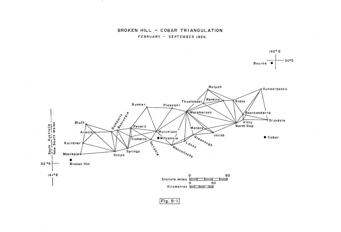
Broken Hill - Cobar triangulation
The Director had made an aerial reconnaissance of the Broken Hill - Cobar area and had selected many stations, proving many of the lines by flying at hill top height. Even so in that type of terrain where the conspicuous ridges were rather flat, wide and timbered and where there was a wide belt of river flats along the Darling, there remained many unsolved problems. An officer from the Canberra office had visited the area in an attempt to solve some of the problems but owing to inexperience in triangulation he had not visited the high points thus little use could be made of his notes.
The reconnaissance party of four with one short wheel base Land Rover and trailer and one Morris 4 x 4 left Melbourne in February. Once sufficient new stations were selected, marking, clearing and cairn building would be carried out by a party of four - one Field Assistant (Survey) and one Field Assistant from the reconnaissance party and two Field Assistants who would be sent from Melbourne. S. Custance, a new Field Assistant (Survey) who would initially be with the reconnaissance party for experience, would take charge of this beaconing party.
Scope Ranges and McCullochs Ranges were two points where it was difficult to select points to fit in with an east-west triangulation scheme; however after considerable checking of lines with heliographs, suitable points were located. A lot of clearing of tough 15 to 20 feet high mulga was necessary at Scope, taking well over a week for four men.
Considerable difficulty was experienced in trying to select suitable stations to form a triangulation chain in the flat country east of the Darling River. It was known that in the old South Australian triangulation the use of the rising of a ray by refraction just on or just after dark had been utilised to provide some rays in their schemes. This principle was used on the ray, Lakes - MacPherson to form an adjustable figure where only a weak single triangle would otherwise have been available. Also at the time of the reconnaissance in autumn, the line Thoolabool - Jacob appeared impossible. When the observing parties arrived in the area in the cold of mid-winter when the rise of refraction is much greater, a large fire was lit on Thoolabool and seen from Jacob; lights were then used to observe this line. This strengthened the scheme enormously.
When the reconnaissance was about one-third complete the two extra field assistants were brought from Melbourne and instruction in station marking, clearing and cairn building was given to the four members of the beaconing party.
It had not been finally decided as yet to “strut” the beacon poles inside the cairn. The first attempt to give them stability in the wind was to use four fencing wire “guys”. Unfortunately, local visitors ruined this method; they could not resist the temptation to lean on, or tug on, the wire “guys”. This soon disturbed the “plumb” of the beacon pole. After this the wooden internal “strut” was adopted with most successful results.
T.M. Austin and R.A. Ford continued with the reconnaissance and completed it early in May. Leaving the beaconing party with plenty of work ahead, they then returned to Melbourne, T. Austin to transfer to the Survey Branch, Department of the Interior, and R. Ford to prepare for observing.
In the meantime, by late May the Senior Surveyor had completed, with great difficulty, the reconnaissance Marree to Oodnadatta. 1955 was the wettest autumn known in that area and Lake Eyre was filled by the run off of the South Australian rivers. This was a rarity; it was often filled by Coopers Creek and the Queensland streams but not the smaller short streams on the South Australian side which had their source in normally rather dry arid areas. He returned to Melbourne in June to recruit some new field staff and to take charge of the Broken Hill - Cobar observing.
The observing party which included one new Field Assistant (Survey), D. Kneebone, who was to be trained as an observer, left Melbourne for Cobar about the end of June, joining the beaconing party which had just completed it's task. Four short wheel base Land Rovers with trailers and one Morris 4 X 4 were available.
Observing commenced at the Cobar end of the scheme; the Senior Surveyor commenced training D. Kneebone and S. Custance in observing techniques, while R. Ford continued to push ahead with the observing as quickly as possible. The weather was cold and often wet with the tracks very boggy; however, progress was reasonable considering there was only one experienced observer. The party paused for a break, the computations of eccentric corrections and triangle misclosures at Wilcannia when the scheme was about half complete. Here D. Kneebone, one of the new observers and one of the field assistants resigned and returned to Melbourne.
1955 had been a wet year in NSW as well as South Australia. During the reconnaissance the Darling had been in flood and that was still the situation in August - September. Although this caused some frustration the two observing parties progressed gradually but steadily on until the observing was completed during September. The field books were finalised and the triangles closed without any check observing. Observing was to First Order standards with average triangular misclosures below one second. It was pleasing to realise that a connection had now been made between the Army primary triangulation network in South Australia right through to the New South Wales primary triangulation network in central New South Wales. Figure 5.1 shows the scheme diagram.
It should be kept in mind that during the period 1951 - 1965 only provisional coordinates on the Sydney datum were produced for horizontal control stations; no attempt was made to adjust loops of triangulation or traverse until the National Adjustment on the new Johnston Origin datum. This took into account all geodetic work completed up to the end of 1965.
Marree - William Creek Triangulation
It was early October when the party moved from Broken Hill to Marree.
The trip by road was a delight; after the heavy autumn rains and floods the country was covered in grass and herbage, a marvellous contrast to the bare drought stricken appearance of twelve months earlier. The Flinders Ranges were indeed beautiful; besides wattle and other shrubs in bloom the hillsides were clothed in red dock which made them a remarkable sight whether viewed from near or far. On arrival in Marree a beaconing party was organised and both beaconing and observing towards Oodnadatta commenced simultaneously. Observing conditions were entirely different from the previous year. With the good grass cover, dust storms were a thing of the past. For a while at least visibility was very good and the hills although not high mostly had a good drop away. The main trouble for both observing and camping was the constant cloud of flies which enveloped anything that moved, one of the drawbacks of the grass coverage which had followed the rain.
By about mid-November the observing was completed to the vicinity of William Creek; it was now very hot in this low area of the continent and the grass had dried off. Observing for the year was discontinued as the vehicles were in poor condition and the observers and some of the field assistants had been in the field since February, except for one short break early in the winter. Triangulation diagram, Marree - Anna Creek is shown in Figure 5.2.
There was one sour note to finish the season. As the observing was drawing to a close the party was instructed that “on the way home” they were to put in a couple of second or third order horizontal control points in the north east of Eyre Peninsula for the use of the Bureau of Mineral Resources. This was an impracticable proposition in the time available as the nearest triangulation chain for a take off point was either well east near Port Augusta or well south from our own second order chain on the east coast of Eyre Peninsula. Much to the party's relief the idea was dropped; in place of it a good quality connection would be made early in 1956 when the balance of Eyre Peninsula and the Gawler Range would be triangulated to First Order standards.
Vertical Control
The same system of observing vertical angles at 1400 hours as used in 1954 was continued. However to provide control, a Commonwealth Railways Bench Mark was located at Marree and a sub-base of about half a mile was measured by a 300 foot steel band, to a point which formed a well shaped triangle with the Bench Mark and Attraction Hill station mark. Horizontal angles were observed at each point to calculate the distances and simultaneous reciprocal vertical angles were also carefully read. Thus a very good height value could be calculated for Attraction Hill. A similar connection had been made at Broken Hill and this method was to be used often in the future. In most cases two Bench Marks were located and the distance between them measured to become the sub-base, thus giving a further check on accuracy.
Geodimeter
During 1955 a comprehensive series of measurements, mainly sides of triangles was completed. However further check measurements were made of the Army base lines at Benambra, Victoria, and Carrieton, SA.
Before moving to Carrieton a Spherical Reflex Mirror, for use at the distant station, was received. It was designed to eliminate the trouble experienced with light beam shifts caused by vertical refraction and proved extremely useful in that respect.
The following is an extract from C.K. Waller's article in “Cartography”. It outlines the measuring program in 1955. As can be seen most of the measurements were between 12 and 15 miles. An attempt to measure the 21 mile line, Mt Dandenong to Quarry Hill, near Melbourne, failed and the measurement had to be done in two parts from an approximate mid‑point.
Date |
Place |
Line Measured |
No. of pairs of Reading f1+f2 2 |
Approx length (Miles) |
Prob. Error (± feet) |
Geod. Minus Survey (feet) (V= 299,792.5 km/sec.) |
Mar 1955 |
Melbourne Vic |
Mt Atkinson-Green (Triangle side) |
4 |
8 |
0.02 |
+ 0.20 |
Mar 1955 |
Benambra Vic |
Geodetic base line |
9 |
6 |
0.02 |
0.00 |
Jul 1955 |
Carrieton SA |
Geodetic base line (Plane Mirror) |
8 |
4 |
0.00 |
+ 0.03 |
Jul 1955 |
Carrieton SA |
Geodetic base line (Spherical Mirror) |
5 |
4 |
0.01 |
- 0.01 |
Sep 1955 |
Mildura Vic |
Paschendale - Yelta |
8 |
5½ |
0.01 |
- |
Sep 1955 |
Ouyen Vic |
Kulwin - Blue Hill |
8 |
11 |
0.02 |
- |
Sep 1955 |
Bendigo Vic |
View Hill - Mt Alexander |
8 |
13 |
0.01 |
- |
Oct 1955 |
Thorpdale Vic |
Thorpdale - Eccles Minor |
6 |
13 |
0.03 |
- |
Oct 1955 |
Thorpdale Vic |
Thorpdale - Houghly |
6 |
15 |
0.03 |
- |
Oct 1955 |
Thorpdale Vic |
Camp Hill - Gentle Annie |
8 |
12 |
0.02 |
- |
Nov 1955 |
Melbourne Vic |
Mt Disappointment ‑ Quarry |
12 |
14 |
0.01 |
- |
Dec 1955 |
Melbourne Vic |
Portion of Quarry Hill-Mt Dandenong |
9 |
10 |
0.00 |
- |
Dec 1955 |
Melbourne Vic |
Portion of Quarry Hill-Mt Dandenong |
6 |
11 |
0.01 |
- |
Summary
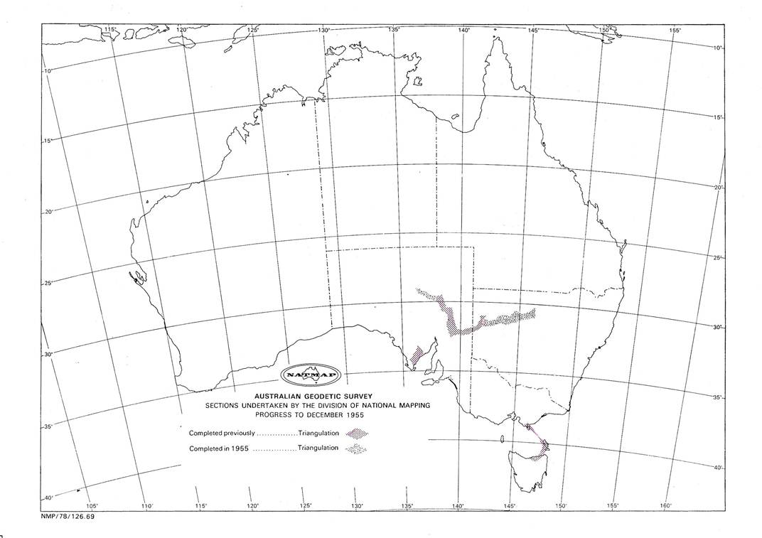
Another very good year’s progress had been made on the primary triangulation chain. Besides reconnaissance beaconing and clearing, some 29 stations were observed between Cobar and Broken Hill an overall distance of 250 miles; between Marree and William Creek some 13 stations were observed, a distance of 100 miles. This gives a total of 42 stations observed and the total length of the triangulation chain completed in 1955 was 350 miles.
Unfortunately, owing to resignations, there were still only two observers available and one of these was still inexperienced. However some field assistants showed promise and it was hoped to give them some training early in 1956.
Field Party 1955
Marree - Oodnadatta reconnaissance, March - June |
||
H.A. Johnson |
Senior Surveyor |
|
G.J. Cruickshanks |
Field Assistant |
|
E. Stuart |
Field Assistant |
(short time) |
Broken Hill - Cobar reconnaissance, February – May |
||
T.M. Austin |
Surveyor Grade 2 |
|
R.A. Ford |
Field Assistant (Survey) |
|
S. Custance |
Field Assistant (Survey) |
Beaconing |
C. Durant |
Field Assistant |
Beaconing |
P. Svoboda |
Field Assistant |
Beaconing |
V. Bouchard |
Field Assistant |
Beaconing |
Broken Hill - Cobar observations. July - September |
||
H.A. Johnson |
Senior Surveyor |
|
R.A. Ford |
Field Assistant (Survey) |
|
S. Custance |
Field Assistant (Survey) |
|
D. Kneebone |
Field Assistant (Survey) |
(short time) |
G.J. Cruickshanks |
Field Assistant |
|
P. Svoboda |
Field Assistant |
(short time) |
V. Bouchard |
Field Assistant |
|
A. Colvin |
Field Assistant |
|
W. Sticklan |
Field Assistant |
|
M. Graetz |
Field Assistant |
|
Marree - William Creek observations, October - November |
||
H.A. Johnson |
Senior Surveyor |
|
R.A. Ford |
Field Assistant (Survey) |
|
S. Custance |
Field Assistant (Survey) |
|
G.J. Cruickshanks |
Field Assistant |
|
V. Bouchard |
Field Assistant |
|
A. Colvin |
Field Assistant |
|
W. Sticklan |
Field Assistant |
|
M. Graetz |
Field Assistant |
|
Geodimeter Party |
||
C.K. Waller |
Surveyor Grade 2 |
|
N.K. Hawker |
Field Assistant (Survey) |
|
J. Slama |
Field Assistant |
|
R. James |
Field Assistant |
(from May onward) |
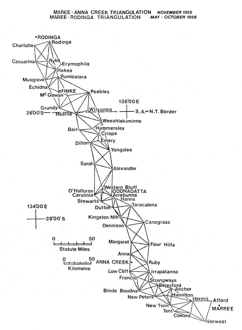
Figure 5.2: Triangulation scheme, Marree - Anna Creek.
Additional Photos
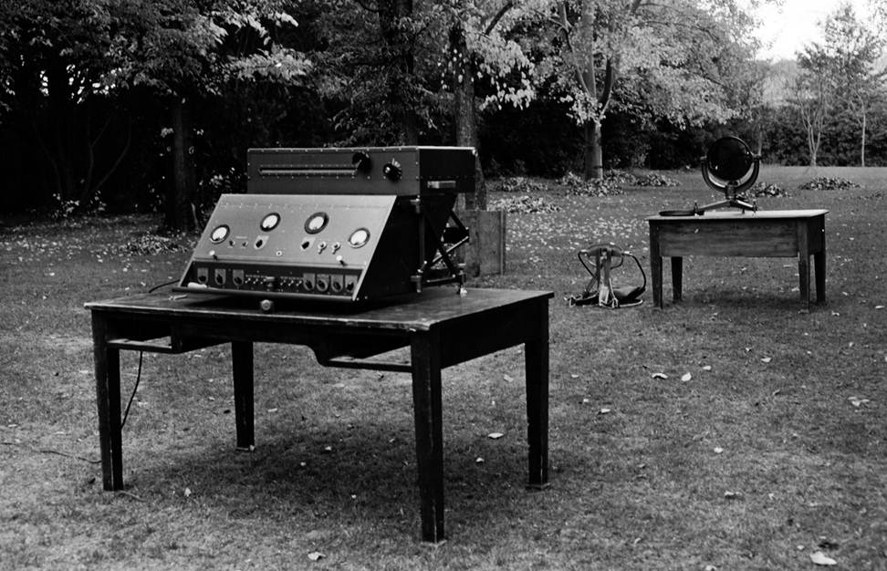
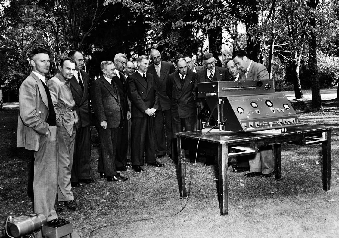
1954 National Mapping Council Members inspecting the Geodimeter in Canberra: (below left to right – only 11 of 13 listed – Ed.), Mr. Fyfe, Surveyor-General Western Australia; Mr. Blackwood, Surveyor-General Tasmania; Mr. Vincent, Surveyor-General New South Wales; Mr. Rogers, Commonwealth Surveyor-General ; Colonel Fitzgerald, Director of Military Survey; Mr. Mellor, Deputy Surveyor-General, Queensland; Mr. Arter, Surveyor-General Victoria; Mr. Rimington, Chief Topographic Surveyor, National Mapping Office ; Mr. Fisk, Surveyor-General South Australia; Mr. Ronstock, Chief Geodetic Surveyor New South Wales; and Mr. Lambert, Director of National Mapping; (above) Geodimeter and reflector.