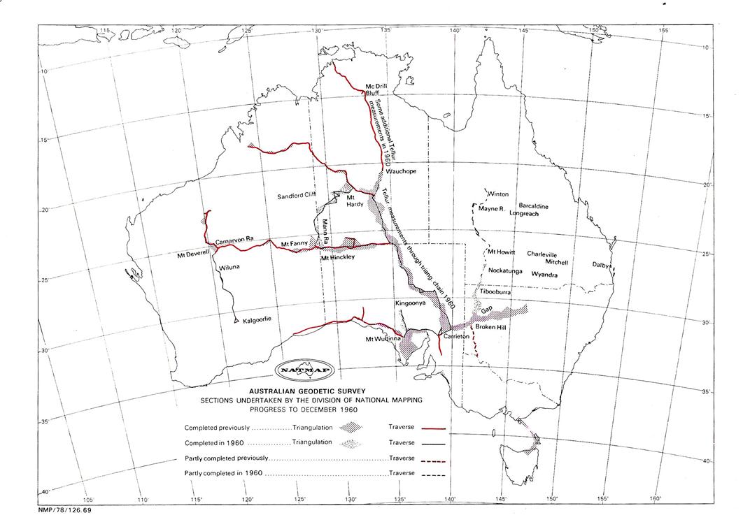
Field Operations 1960
The 1960 field program was arranged as follows:
(i) Carrieton, SA - Wauchope Area, NT.
Distance measurements through triangulation chain under O.J. Bobroff
(ii) Kalgoorlie, WA - Carnarvon Ranges, WA.
Observations and measurements.
&
Mt Fanny, WA - Mt Hardy, NT.
Beaconing, observations and measurements under A.H. Spowers
(iii) Kingoonya - Mt Wudinna, SA.
Beaconing, observations and measurements.
&
Tibooburra, NSW - Winton, Qld. - Reconnaissance and
Nockatunga - Dalby, Qld. - Reconnaissance.
&
Broken Hill, NSW - Winton, Qld
Beaconing and as much observing as possible under R.A. Ford
The end of the 1959 season saw a large exodus of field staff similar to that of 1954. M.A. Nicholas resigned and also most of the field assistants. New field assistants had to be engaged and the few observers allotted to best advantage.
WA - NT Survey Party
As he passed through Adelaide en route Kalgoorlie, A. Spowers again collected some WRE personnel and vehicles to supplement his party. H. Couchman was the only experienced observer, however field assistant D. Hutton had already been given considerable training. A. Spowers supervised his final training on the job, making two observers available for the Kalgoorlie - Carnarvon Range traverse.
As this had been beaconed the previous year, observing and measuring commenced immediately the party arrived in the area. Twenty-three stations and 450 miles of measurements were completed on this traverse.
R. James left Melbourne separately collecting the balance of the WRE personnel and vehicles in Adelaide. This party then moved to the Giles area and beaconed the traverse, Mt Fanny, WA - Mt Hardy, NT which had a spur from Mt Farewell to Sandford Cliff. This point is near the eastern shore of Lake Mackay which straddles the WA-NT border. They then commenced observing and were later joined by A. Spowers and his survey party which had just completed the Kalgoorlie - Carnarvon Range traverse. The Mt Fanny ‑ Mt Hardy traverse was observed and measured, 22 stations and 400 miles in all.
The party then turned south, to the Kingoonya area of SA Here they beaconed, observed and measured the Kingoonya - Mt Wudinna traverse before returning to Melbourne at the end of the field season.
This traverse involved ten stations; the distance measured was 110 miles.
Broken Hill, NSW – Winton, Queensland Survey Party
Owing to a lack of experienced observers and field assistants commencing operations were difficult to arrange. It was decided the best method was for R. Ford and two field assistants to push ahead with the reconnaissance leaving G. Cruickshanks to beacon the hills already selected by M.A. Nicholas. He would then commence training R. Collins (ex Tellurometer party) as an observer. On completion of the reconnaissance R. Ford would return and organise the full observing and beaconing program.
The traverse was to be reconnoitred to include side points wherever possible, so that the quality of the observing could be checked as well as a check for gross error in the Tellurometer measurements.
The reconnaissance was commenced just north of Tibooburra at the last points selected in 1959. The terrain was not easy for the type of traverse required however steady progress was made in selecting fourteen stations to Mt Howitt a distance of about 180 miles where the party was marooned for a week during very heavy rain. It was now not possible to move ahead, that route being barred by floods along Coopers Creek and local people advised that it would be at least another three weeks before it would be possible to work further north in that area.
There was only one solution. Try to get out to the east to Charleville then go north up the sealed road to Winton via Barcaldine and Longreach. At Winton the reconnaissance would be recommenced moving from north to south. With difficulty the party got to Charleville; after that it was easy going to Winton.
Conditions were entirely different in the Winton area as drought conditions prevailed. No difficulty was experienced in the first week and six stations were selected. However in the Mayne River area the terrain became both flat and timbered and it appeared towers would probably be necessary. Just at this time G. Cruickshanks telegraphed to advise that he was ill and would have to return to Melbourne. There was no alternative but to make the long return trip as there was no one in the party experienced enough to take charge of the beaconing or to do the observing. A telephone discussion with the Senior Surveyor confirmed this was the only solution as G. Cruickshanks was unlikely to return to field duty for some considerable time. He also said that the traverse could be swung well to the west and then south along the Diamantina River to avoid the timbered flat area near the Mayne River.
Once again making the wide detour via Charleville the reconnaissance party arrived back in the Tibooburra area and met the beaconing team; here it was revealed that one field assistant had resigned and returned to Melbourne with G. Cruickshanks.
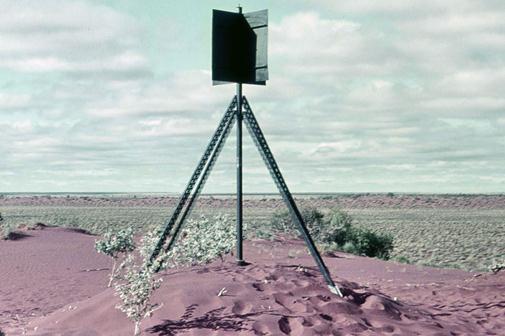
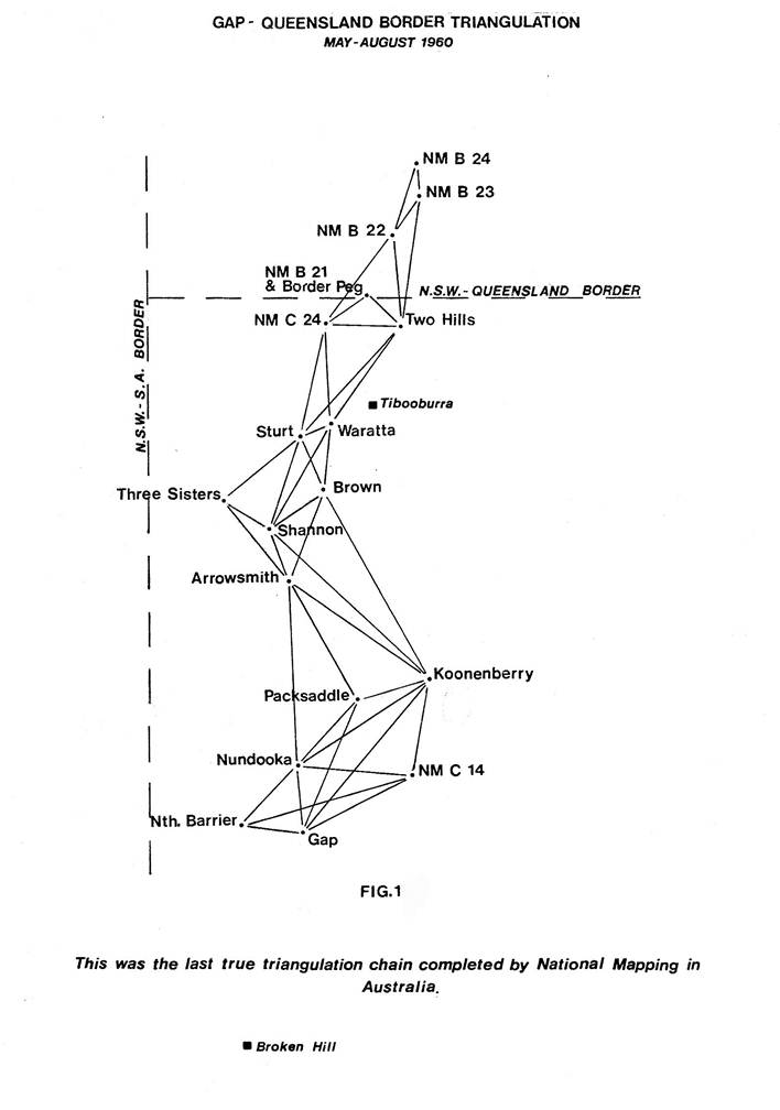
The last couple of beacons were erected and observing commenced, along with training for R. Collins. This section between Gap and the NSW-Queensland border was once more a triangulation scheme, 23 triangles were closed, the average misclosure being 0.59 second. Figure 1 shows the scheme until it became a traverse just north of the border. To enable a connection to a border survey peg ZO 221, a point was selected on a small residual some 1800 yards from the peg. While making this connection the party once again got into trouble because of heavy rain. This downpour prevented movement for one week and even after that time the next move had to be made with the assistance of a Ferguson tractor.
All stations that had been beaconed had now been observed. It was decided to adopt a new technique for the stations ahead. A beaconing party went ahead, set in the station mark, erected the pole and vanes, strutting it with four ten feet lengths of “Unimet”, and cleared the lines. No cairn was built at this stage thus they were able to move ahead fairly quickly.
The observing party dismantled the strutted beacon pole and completed the observing from the station mark, saving any need for eccentric corrections to the observed angles. Reference marks were also set exactly on line to the distant stations so that Tellurometer eccentric corrections would be just the addition of the distance, RM to station mark. Once the observing was finished the observing party either built the normal cairn themselves or left it for the beaconing party's return, arrangements to suit circumstances being made by radio. All stations to Mt Howitt, the most northerly point of the reconnaissance, were completed in this manner and during this period training in observing was commenced for Field Assistant, R. Maruff.
It was now decided that the party leader should press ahead with the reconnaissance leaving R. Collins to complete the beaconing, also completing the necessary simultaneous reciprocal vertical angles with R. Maruff as the other observer.
The country along Coopers Creek had dried out long ago, it now being September. Some difficulty was experienced in siting the station on the northern side of Coopers Creek, the line being long and low; it was proved by lighting two large fires after dark. The reconnaissance was gradually edged westward towards the Diamantina River, then following it to Macartney Range and from there nearly due east for two lines to Mt Davy and Mt Holberton, the two most southerly points selected earlier in the year. From the NSW-Qld border to Mt Cathedral near Winton forty traverse stations were selected, the distance being 500 miles.
A beaconing party under R. Collins was organised to beacon and clear the stations between Mt Howitt and Mt Cathedral while the party leader and two field assistants commenced the west to east reconnaissance from the vicinity of Nockatunga to Dalby.
Maps showing the line the traverse was to take and possible station sites had been provided by the Canberra office. Progress was reasonable at first but even so the lines were much shorter than those shown optimistically on the map. Gradually the lines became shorter and shorter as only low timbered undulations were encountered until in the vicinity of Wyandra (due south of Charleville) the country became a timbered plain. A feasibility reconnaissance was quickly made to the east by visiting all sites selected in the office and plotted on the reconnaissance map. It was soon apparent that towers of at least 60 feet would be needed to traverse in this country, and they would only provide short lines.
It was therefore decided to move north some sixty miles to the Charleville - Brisbane road as from a previous visit it was known that there was open farming country and some hills along the road to the east. The reconnaissance was commenced again at Mitchell and soon a reasonable traverse was selected to within sight of the Great Dividing Range near Dalby which meant that from Dalby to Mitchell was traversable and only a section centred on Charleville would cause much difficulty.
This was
reported by phone to the Senior Surveyor who agreed the traverse could be moved
north. It was also suggested that the Charleville area be reconnoitred by
aeroplane first. He agreed, but on finding out that the thunderstorms had
started and the visibility was now continually rather poor, decided this should
be done at the start of the next field season. ![]() As
it was late in the year the party should close down operations and return to
Melbourne.
As
it was late in the year the party should close down operations and return to
Melbourne.
The beaconing party having completed their task arrived at Mitchell and the party returned to Melbourne. It had been a frustrating year owing to very wet and boggy conditions for a considerable time, and particularly to the fact that the party leader was the only experienced observer and reconnaissance officer in the party. However in spite of this, one very long traverse had been reconnoitred, beaconed and a large section had been observed. In addition the feasibility of another long traverse had been proved.
Tellurometer Party
O.J. Bobroff took over the Tellurometer party, however as most of the previous party had resigned it was more a matter of starting afresh. His task was to select and measure a traverse from the sides of the triangles in the triangulation chain northward from the Carrieton base line to the Wauchope area in the NT where the triangulation chain ended at Devils Marbles. From that point northward the survey was carried forward by a Tellurometer/Theodolite traverse. In the Wauchope area, as mentioned in Chapter 7, all lines of two triangulation figures had been measured with the Tellurometer by C.R. Waller for research purposes. Check measurements were to be made along some of these lines.
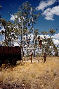
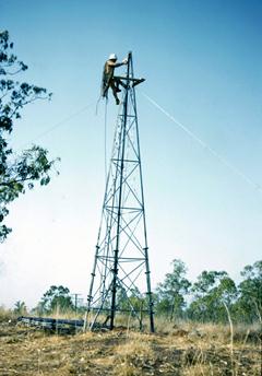
A variety of country was crossed during this traverse, from the high peaks of the Flinders Ranges to the low rises near Lake Eyre. From then on generally the stations were on residuals until arrival in the NT where solid hills were again encountered including some points in the MacDonnell Ranges. From here the hills were of average height until they became only low rocky ridges in the vicinity of Wauchope. Figure 2 shows Tellurometer equipment being carried up Mt Everard on the northern fringe of the MacDonnell Ranges.
The next task was on the Mataranka - Powell Creek tower traverse where those lines with only single measurements were to have a second measurement made to bring them to First Order standards. In addition preliminary computations had shown there was a gross error of twelve minutes in the angular observations and this was to be located.
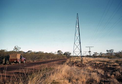
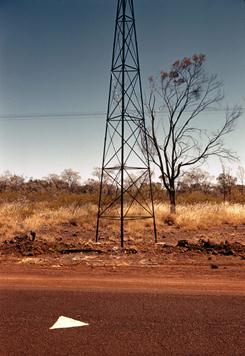
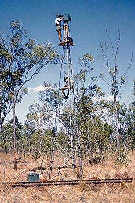
As there were only four persons in the party it would have been uneconomical to erect both towers and scaffolding so a simpler method had to be planned. Firstly the tower feet were modified to have a sliding adjustment for plumbing accurately over the station mark. Secondly a small “catwalk” was designed and attached to the tower with steel brackets at a height where a person standing on the “catwalk” would be at eye level height with any instrument mounted on the top of the tower.
The tower was now assembled, “catwalk” and tower head attached. It was pulled upright, plumbed over the mark and “guyed”. The Tellurometer operator now climbed the tower, stood on the “catwalk” and secured himself with a linesman's safety belt. The equipment was now hauled up and the line measured.
When the measuring was complete the check for gross error in the angular work was made. The theodolite was set up with two men on the “catwalk”. One laid on the reference object, then gently turned the instrument for the other to read the angle. If both were careful in their movements an angle within about half a minute resulted which was sufficiently accurate in view of the large gross error they were required to locate.
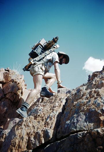
Figure 2: Backpacking Tellurometer equipment up Mt Everard, MacDonnell Ranges, NT. : R.W. (Bob) Goldsworthy.
In the final event the twelve minute error was found to be made up of two gross errors, one of twenty minutes and the other of eight minutes.
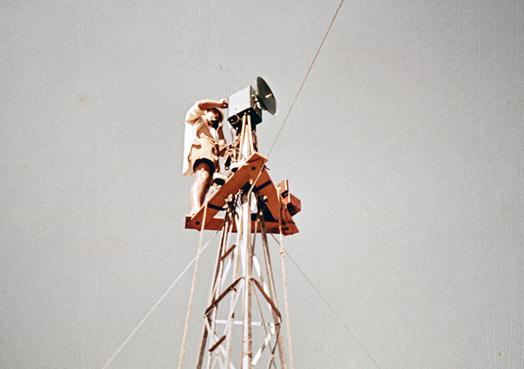
The method of using the “catwalk” on the tower itself for both measuring and the angular check made possible the completion of this work with a very small party and saved days of laborious scaffold building. Figure 3 shows the fully assembled observing tower with “catwalk” attached after transport from the previous station and Figure 4 shows the operator measuring a line from the top of the tower.
The tower equipment was again stored at Alice Springs and the party returned to Melbourne in November.
During the year approximately 80 lines were measured, a distance of 1500 miles.
Summary
A lot had again been accomplished by all parties and the traverse loops were now taking shape. Owing to the lack of trainee staff the year had started badly and certainly a lot more could have been accomplished if only one more experienced observer had been available.
Details of the Years Work:
|
Carrieton SA – Mataranka, NT |
(Measurements only) - 1500 miles |
|
Kalgoorlie - Carnarvon Ranges, WA |
Traverse - 450 miles |
|
Mt Fanny NT - Mt Hardy, NT |
Traverse - 400 miles |
|
Kingoonya - Mt Wudinna, SA |
Traverse - 110 miles |
|
Broken Hill NSW – Winton, Qld. |
Recce & angular measurements only – 780 miles |
Field Parties 1960
|
WA - NT Traverses |
|||
|
|
|||
|
A.R. Spowers |
Surveyor Grade 2 |
||
|
R. James |
Field Assistant (Survey) |
||
|
H. Couchman |
Field Assistant (Survey) |
||
|
D. Hutton |
Field Assistant (Survey) |
||
|
J. Carlyle |
Field Assistant |
||
|
J. Coles |
Field Assistant WRE |
||
|
A. Hooper |
Field Assistant WRE |
||
|
G. Stanley |
Field Assistant WRE |
||
|
L. Boss |
Field Assistant WRE |
||
|
E. Skeen |
Field Assistant WRE |
||
|
|
|
||
|
Broken Hill - Winton Reconnaissance, Beaconing and Observing |
|||
|
|
|
||
|
R.A. Ford |
Surveyor, Grade 1 (Acting) |
||
|
R. Collins |
Field Assistant (Survey) |
||
|
R. Maruff |
Field Assistant |
||
|
F. Combe |
Field Assistant |
||
|
J. Kelly |
Field Assistant |
||
|
C. Hale |
Field Assistant |
||
|
G. Cruickshanks |
Field Assistant (Survey) |
(Few weeks only) |
|
|
G. Yodgee |
Field Assistant |
(Few weeks only) |
|
|
|
|
||
|
Tellurometer Party |
|||
|
|
|
|
|
|
O.J. Bobroff |
Surveyor Grade 2 |
|
|
|
G. Rosenberg |
Field Assistant |
|
|
|
R. Goldsworthy |
Field Assistant |
(Part time only) |
|
|
D. Wicks |
Field Assistant |
|
|
|
W. Jacobs |
Field Assistant |
(Part time only) |
|
|
F. Dare |
Field Assistant (Survey) |
(Part time only) |
|
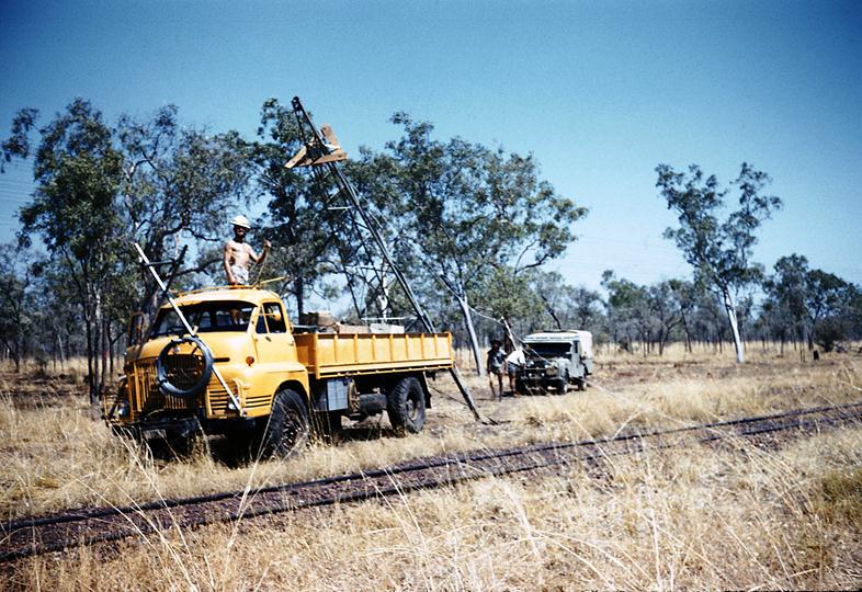
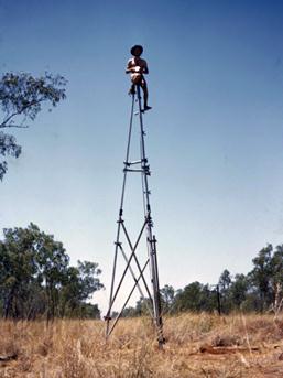
Figure 3: Unloading fully assembled observing tower with “catwalk”.
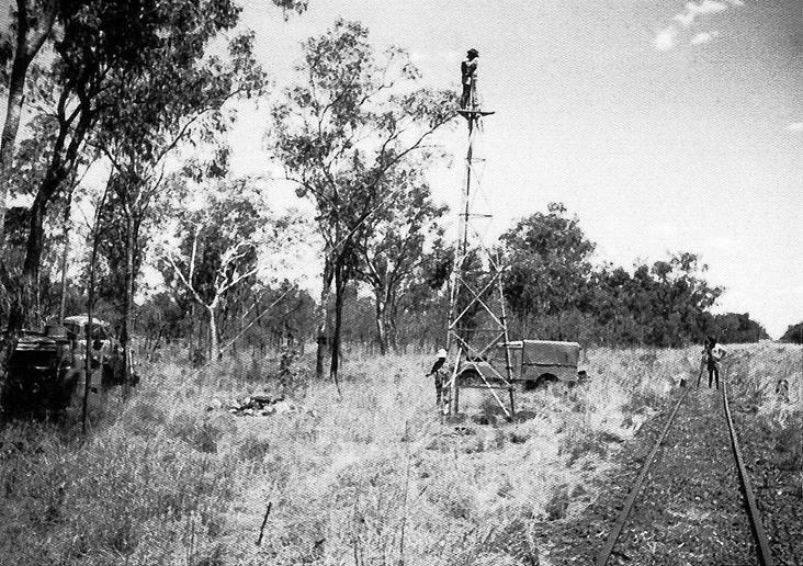
Figure 4: Measuring a line from the top of the tower.