John Robert Woodger (1936-2009)
National Mapping Technical Officer 1966-1999
by Laurie McLean
July 2019
John Woodger, or Woody as he was known in Nat Map, was highly respected as a diligent and hard working technical officer. Initially Woody worked in the field on levelling surveys and later in the Mount Stromlo and the Orroral Observatories when he was engaged in photographic zenith tube operations, national time keeping and laser ranging activities. Woody’s former work colleagues remember him as a good mate and as an ultra-reliable salt of the earth honest man.
Woody was a man of many talents. His work abilities ranged from fruiterer to surveying technician and to astronomical scientist. In the field he was able to cook seasoned dampers in a camp oven. These were much appreciated by all field party members and provided a welcome and tasty relief from the otherwise fairly monotonous diet of canned food. In the mid-1970s, more than a decade before there was a world wide web, Woody was using a computer linkage to communicate with time service work colleagues in overseas organisations. Perhaps more importantly Woody was a devoted husband and loving father and grandfather.
John Robert Woodger was born at Queanbeyan on 23 January 1936. He was the third of the four children born to Phillip Thomas Woodger (1909-1994) and his wife Jean Elizabeth Woodger née Agnew (1908-1997). John Woodger’s siblings were his older brothers Phillip Thomas (who sadly died at one-day old on 20 December 1931) and Thomas Henry (Tommy) (1933-2008) and his sister Jeanette (later Mrs Bob Knight).
About John Woodger’s parents and grandparents
John Woodger’s parents Phil and Jean Woodger married on 29 March 1931 at St Michael’s Church of England on the corner of Albion and Flinders Streets in the inner southern Sydney suburb of Surry Hills; the Reverend Arthur Morris officiated at the wedding ceremony.
John Woodger’s mother Jean Agnew was the sixth of seven children born to Henry Agnew (circa 1867-1949) and his wife Margaret Adams Agnew née Colquhoun (circa 1868-1949). Jean Agnew was born on 31 October 1908 and her birth was registered at Cooma. From electoral rolls in the 1930s and 1940s Henry Agnew was a hairdresser residing at Cooma. In 1930 Jean Agnew was working as a shop assistant in Cooma.
John Woodger’s father Phil was born at Queanbeyan on 26 July 1909. He was one of the seven children born to Thomas Ernest Woodger (1872-1961) and his first wife Catherine Ruth Woodger née Weir (1874-1915). Thomas Woodger and Katie Weir married at Queanbeyan in 1899. Katie was one of the seven children of William Weir (1846-1913) and his wife Sarah Ann Weir née Rolfe (1844-1921). Thomas Woodger was a Queanbeyan-based auctioneer; for more information on T E Woodger please refer to Appendix A.
In 1918, some three years after the death of his first wife, Thomas Woodger married Cecilia Mary Emily Turnbull née Armstrong (1876-1959). Their marriage was registered in the Glebe registry district in 1918. Cecilia was the widow of Percy Frederick Turnbull (1871-1915). Percy was a gaol warder and former police constable who died of pneumonia at Parramatta, aged 44 years.
From electoral roll entries during the 1930s John Woodger’s parents Phil and Jean Woodger resided in Queanbeyan where Phil was an auctioneer (on 1934 and 1935 rolls) and a dealer (on 1936 and 1937 rolls.) On all of these electoral rolls Jean was occupied with home duties.
John Woodger’s father’s World War II service
John Woodger’s father Phil Woodger served in the Australian Army during and after World War II. Phil enlisted at Paddington on 22 January 1942 at age 32 years; Service Number NX85276. He was discharged in Melbourne on 22 July 1948. Phil Woodger had 2 374 days of active service with the Army including 1 427 days of active service in Australia and 847 days of active service outside Australia.
Phil Woodger served in the Second Australian Imperial Force until 30 June 1947 and then in the Interim Army until discharge. The Interim Army was created at the end of World War II when the AIF was disbanded and while the Australian government consulted with the British government on the future size and structure of the Australian Army. For more information see Sligo (1997). Immediately prior to discharge Phil Woodger was a sergeant with the British Commonwealth Occupation Force (BCOF) Headquarters Signal Regiment at Kure in Japan. Phil Woodger served with the British Commonwealth Occupation Force in Japan between 29 March 1946 and his Army discharge on arrival in Melbourne on 22 July 1948. The main role of the BCOF was to enforce the terms of the unconditional surrender that had ended the war in the Pacific in September 1945.
The BCOF was required to maintain military control and to supervise the demilitarisation and disposal of the remnants of Japan's war-making capacity. The BCOF area of responsibility was the western Japanese prefectures of Shimani, Yamaguchi, Tottori, Okayama, Hiroshima, and Shikoku Island. The BCOF Headquarters was at Kure, about 20 kilometres south east of Hiroshima.
Living and working at Cooma
While Phil Woodger was in the Army his wife Jean was listed on a 1943 electoral roll as residing with her parents (Henry and Margaret Agnew) in Bombala Street Cooma and being occupied with home duties. Here Jean raised her young family through the War and the following three years without the direct support of her husband.
After Army service Phil Woodger and his wife Jean and their children settled in Cooma. On electoral rolls between 1949 and 1980 Phillip and Jean Woodger were listed as residing in Cooma where Phil was occupied as a greengrocer and Jean in home duties. At some time after 1980 Phil and Jean Woodger moved to Canberra and settled in MacGregor.
John Woodger reached the age of 21 years in January 1957 and thereafter was eligible to register as a voter on the electoral roll. John was initially listed on electoral rolls for 1958 and 1963 together with his older brother Tommy. Both were listed as residing with their parents in Cooma and being occupied as fruiterers; while, as mentioned, their father Phil was occupied as a greengrocer.
On electoral rolls for 1977 and 1980 Tommy Woodger was listed as residing with his parents in Cooma and being occupied as a prison officer.
Marriage to Anne Day 1964
John Robert Woodger and Anne Day married in the central New South Wales city of Dubbo in 1964. Anne Day’s family owned the property Wonga to the north of the small town of Tottenham that is located about 120 kilometres west of Dubbo. On a 1963 electoral roll, Anne Day was listed as residing at Wonga, Tottenham and being occupied as a station hand. John and Anne Woodger were to have two children: daughter Roseanne and son Peter John.
Working with surveyor Harry Granger in the 1960s
Harry William Granger (1928-1977) practised as a licensed surveyor in Cooma from about 1956 to 1966 when he moved to Canberra to work with the Division of National Mapping. Harry had also worked as an assistant surveyor in Cooma prior to 1956. About 1961, while practising in Cooma Harry Granger engaged John Woodger as a chainman (Willington, 2019 and Woodger, 2019). Woody came to Canberra in late 1966 about the time Harry Granger commenced with Nat Map.
Woody’s Nat Map service 1966-1987
In late 1966, at 29 years of age, John Woodger joined Nat Map as a technical officer and continued in that organisation until mid-1987. In July 1987 Nat Map was amalgamated with the Australian Survey Office to form the Australian Surveying and Land Information Group within the Department of Administrative Services. As discussed below John continued working with AUSLIG until early 1999.
Nat Map Precision Levelling Section 1967-1972
From late 1966, Woody worked as a technical officer with Nat Map’s Canberra‑based Precision Levelling Section in the Geodetic Survey Branch. His appointment to that position in the Department of National Development was promulgated in the Commonwealth of Australia Gazette on 4 May 1967. However, at that time in Nat Map it was not uncommon for field survey staff appointment and other gazettals to lag actual commencement by some months or even years.
Nat Map’s Precision Levelling Section
In 1962 Nat Map had commenced an accelerated national program of control levelling which culminated in the determination of the Australian Height Datum in 1971. That Datum provided Australia for the first time with an accurate and homogeneous levelling system for mapping and other purposes.
Nat Map’s Precision Levelling Section was established in 1966 under senior surveyor Klaus Leppert (1925-1995) who was promoted in December 1969 and replaced by Harry Granger. Together with then field assistant Andy Rogers, Woody was one of the foundation members of the Section. The Precision Levelling Section undertook precise differential levelling surveys for which private sector levelling contractors were not available. As well, the Section undertook other work (including tide gauge observations) required to complete the Australian levelling network.
The Section also checked the work of levelling contractors and connected the Australian levelling network to geodetic survey stations on the Australian Geodetic Datum. The Section also connected Aerodist photogrammetric mapping control stations to the Australian levelling network.
Levelling field work
In the Geodetic Levelling Section John Woodger undertook extensive periods of field survey duty in the more remote areas of Australia as a sub-party leader engaged in establishing permanent levelling bench marks and observing and recording precision levelling to required accuracy specifications. As a field sub‑party leader, John was the instrument man who used an automatic level to read figures on levelling staves to determine height differences.
Woody worked with two field assistants who were the staff men. Each staff man held a levelling staff about 300 feet from the instrument man; one to the back and one to the front (of the direction of travel) as the levelling work progressed. The nature of the work during the years that John undertook levelling activities is indicated in the following overviews of the 1968 and 1969 field survey seasons.
In 1968 John Woodger was one of three sub-party leaders in a levelling field survey party under Harry Granger. That year the field party’s activities took place in Queensland (north of 24º South latitude) and in the Northern Territory (east of the Stuart Highway). The activities included connecting selected trigonometrical, traverse and Aerodist stations and a Hiran station to the National Levelling Network; identifying the exact location of permanent bench marks on aerial photographs; check levelling between permanent third order bench marks established by levelling contractors; making levelling connections between traverses on either side of the Queensland-Northern Territory border; and making levelling connections at tide gauge stations and the nearest State bench marks.
The 1968 sub-parties under Harry Granger comprised:
|
Sub-Party 1 |
Sub-Party 2 |
Sub-Party 3 |
|
Fred Reardon TO 1 |
Mike Whalen TO 1 |
John Woodger TO 1 |
|
Dick Mooney FA |
John Rutherford FA |
Andy Rogers FA |
|
Ken Byrne FA |
Peter Walkley FA |
Joe Murray FA |
In 1969 the Precision Levelling Section’s field survey work was undertaken in the Northern Territory west of the Stuart Highway and between Robinson River and Wollogorang (on National Route 1 in the Gulf of Carpentaria area of the Northern Territory). The Section also operated in the Great Sandy Desert and the northern Gibson Desert in Western Australia east of the small town of Marble Bar.
In 1969 John Woodger was again a sub-party leader in the levelling field survey party under Harry Granger who rotated the field party leadership with surveyor Peter O’Donnell. The 1969 sub-parties comprised:
|
Sub-Party 1 |
Sub-Party 2 |
Sub-Party 3 |
|
Don Gray TO 1 |
Fred Reardon TO 1 |
John Woodger TO 1 |
|
Steve Klein FA |
Ken Byrne FA |
Andy Roders FA |
|
Joe Murray FA |
Dick Mooney FA |
Harry Wilson FA |
Also in 1969, Bob Bryant was a relieving technical officer and field assistant Peter Walkley was the driver of the RLCH model Bedford supply truck. Bob Bryant relieved the other technical officers so they could spend some time back in Canberra and have time with their wives and families. Phil Allen replaced Harry Wilson (who had resigned) at Port Headland in late July 1969 (Allen, 2019).
[The author who was a field assistant operating with Nat Map’s Aerodist ground marking field survey party met Peter O’Donnell and other members of the Precision Levelling Section field party at Marble Bar in late July 1969.]
John Woodger continued working in Nat Map’s Precision Levelling Section until the mid-1970s. Nat Map’s levelling field work was considerably reduced after the determination of the Australian Height Datum in May 1971.
Levelling in the Northern Territory 1974
Woody's last field trip with the Geodetic Levelling Section was in 1974 when he worked in a field party led by surveyor Barry Sloane. That year the field party was making levelling connections to Aerodist survey control stations (10‑inch square blocks of concrete with marker posts) in the Northern Territory.
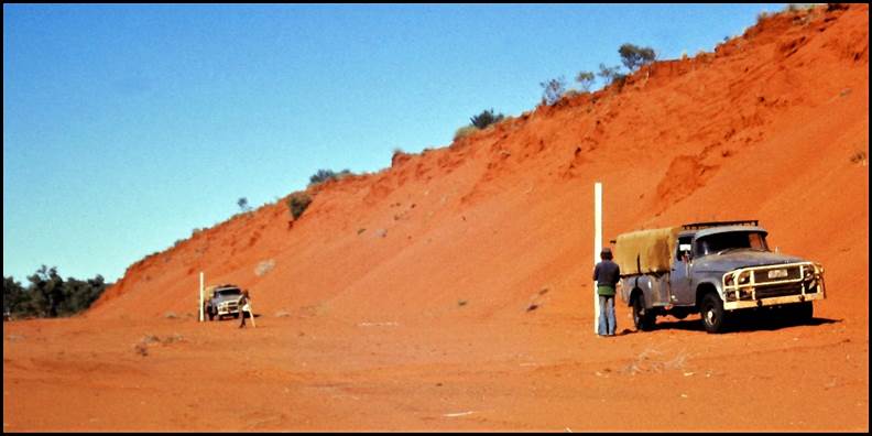
John Woodger and team levelling down the Hay River in the Simpson Desert in 1974.
Barry Sloane image.
One task was to level through the Simpson Desert along the (dry) Hay River to Aerodist station NM/B/296 located on the Northern Territory-Queensland border at 25° South latitude and 138° East longitude. The Aerodist station was located over the sandhills some 17 kilometres or so from the end of the Hay River; see map composite below.
The Simpson Desert was named for Alfred Allen Simpson (1875-1939) grandson of the founder of the then Adelaide-based appliance manufacturer. AA Simpson was the sponsor of a 1939 expedition led by Dr Cecil Thomas Madigan (1889-1947) an Adelaide-based geologist and explorer who had been in Antarctica with Douglas Mawson.
Using around 20 camels, Madigan’s 9-man party made the second recorded crossing of the Simpson Desert. On a scientific survey, the party headed generally east from (old) Andado homestead about 250 kilometres south east of Alice Springs to Birdsville; a distance of over 400 kilometres. Among the Madigan party members were palaeontologist Harold Oswald Fletcher (1903‑1996) who had also been in Antarctica with Mawson and radio operator Robert Allen Simpson (1912-1996), a son of the sponsor.
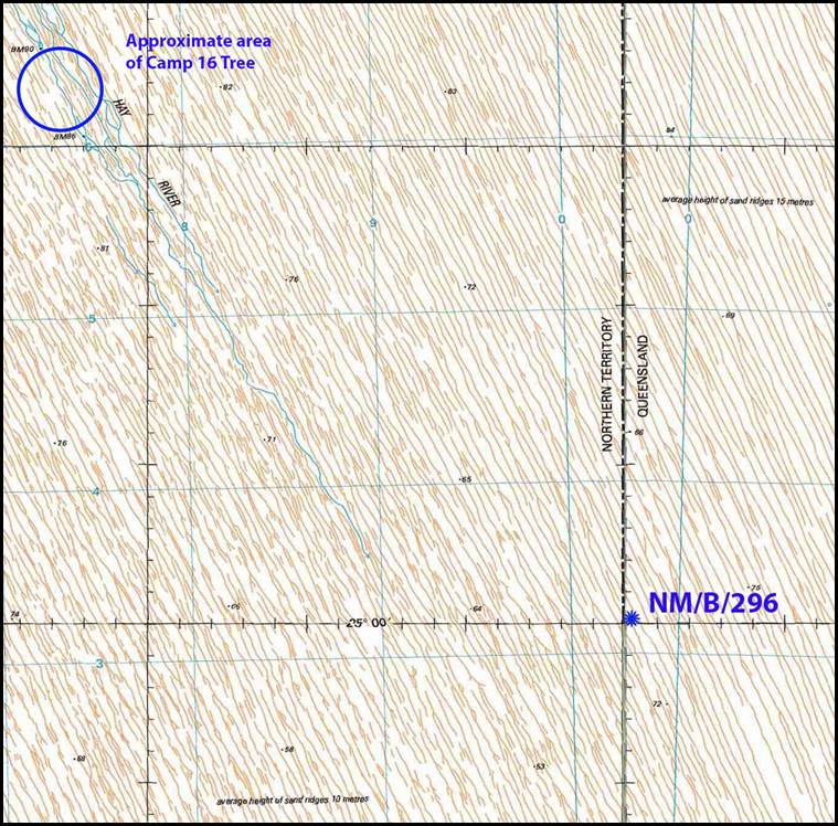
Topographic map composite showing NM/B/296 in relation to the Hay River.
Map composite prepared and annotated by Paul Wise.
[The first recorded crossing of the Simpson was by Edmund Albert Ted Colson (1881-1950) and Eringa Peter an Antakurinya man. On 26 May 1936 with five camels, they left Blood’s Creek on the Overland Telegraph Line about 150 kilometres north of Oodnadatta. Using a compass they headed east along the 26° South parallel to near the Poeppel's Corner three-way border junction and arrived at Birdsville on 11 June 1936. Three days later Colson and Peter started their return to Blood’s Creek and arrived home on 29 June 1936. Colson had relied on lush growth following good rains to sustain his camels. The South Australian Government (under Premier Richard Butler) would not recognise Colson’s unofficial Simpson crossing.]
Nat Map Aerodist station NM/B/296 had been establish in July 1968 by a helicopter-borne survey party that flew out of Birdsville. In 1974 Barry Sloane used aerial photographs and observations on the sun and on selected stars to successfully navigate his vehicle-borne levelling party through the desert to the Aerodist station. During the trip Barry’s field party found a tree blazed M 39 by Madigan’s party in 1939. On reaching the Hay River Madigan established his Camp 15. Madigan’s party then travelled down the Hay for about 15 or 20 kilometres to Camp 16 where the tree was blazed. After Camp 16 Madigan’s party moved east away from the river on their trek to Birdsville. The approximate area of Camp 16, based on a map in Madigan (1946), is shown on the map composite above.
At the Madigan Camp 16 tree the 1974 Nat Map levelling field party placed a star picket with an aluminium plate attached. On the plate, then technical assistant Peter Walkley had stamped the surnames and first initials of the Nat Mappers who were there at that time, namely: Barry Sloane, John Woodger, Peter Walkley, Rod Small, Phil Cardiff, and Ross Edmonds. Images of the Camp 16 tree in 1974 and in 1939 as well as the 1974 Nat Map plaque are provided below.
When working down the Hay River in 1974, Woody’s abilities around the overnight survey camps were much appreciated by other field party members. As previously mentioned, Woody was able to cook delicious seasoned dampers in the camp oven. These were greatly enjoyed by all field party members and provided a welcome and tasty relief from the otherwise fairly monotonous diet of canned food. In an image below, field party members are seen helping Woody finish cooking one of his dampers…with eager anticipation!

John Woodger in 1974 at the blazed tree at Madigan’s 1939 Camp 16 site on the Hay River in the Simpson Desert.
Barry Sloane image.
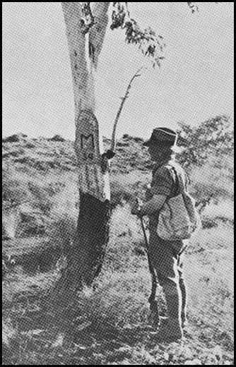
Harold Fletcher at the Camp 16 tree in 1939.
Image from Madigan (1946).
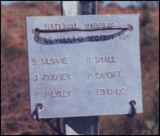
Plaque placed at the Madigan Camp 16 tree by Nat Map in 1974.
Barry Sloane image.
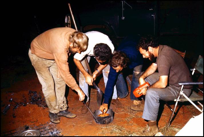
Checking the damper in the Simpson Desert in 1974.
L-R: John Woodger, Don Gray, Ottie Syrch and Barry Sloane.
Image supplied by Barry Sloane.
Map compilation 1972
In 1971, Nat Map’s director Bruce Lambert decided to cease the high precision traversing work that had been undertaken by Nat Map’s Geodetic Survey Branch since 1968. As a consequence some Canberra staff were redeployed to map compilation work. In early 1972 Nat Map surveyors Brian Murphy and Peter O’Donnell undertook a six-week summer school in photogrammetry run by Sjef Bervoets at the University of Melbourne. A few months later Brian trained John Woodger on photogrammetric map compilation using a Wild B8 stereoplotter at the Australian Survey Office in Canberra. Around the middle of 1972 John worked on the ASO B8 plotter with Brian Murphy to plot some 1:100 000 scale compilation sheets in the Albany area of Western Australia (Murphy, 2019).
Nat Map Geodetic Astronomy Section circa 1972-1987
After some years of dedicated levelling field work John Woodger joined Nat Map’s Geodetic Astronomy Section that then operated from the Mount Stromlo Observatory about 12 kilometres west of Canberra’s city centre.
Woody’s promotion to technical officer grade 2 (science) in the Positional Astronomy Section of Nat Map’s Geodetic Branch was promulgated in the Commonwealth of Australia Gazette on 24 May 1973. However, John had already been working at Mount Stromlo for some time prior to this gazettal.
Initially, in the Astronomy Section John made observations on stars for time and latitude determination using the 10-inch photographic zenith tube located at the Mount Stromlo Observatory. He also undertook statistical checks of results; programmed a computer for PZT star measurements and tables; prepared and reduced the PZT plate data and programme to calculate reduction constants.
For a more detailed overview of the Mount Stromlo photographic zenith tube please refer to Appendix B. As the Mount Stromlo work involved star observations John had traded extended periods of remote area levelling field work for shift work undertaking astronomic and related observations.
From around late 1974 or early 1975, Woody operated from the newly established Orroral Geodetic Observatory in the Namadgi National Park about 60 kilometres south of Canberra. After construction of the Observatory was complete in October 1974, three caesium clocks from Mount Stromlo were installed at Orroral by the United States Naval Research Laboratory. By early 1977, Nat Map had received an additional caesium clock on loan from the US Naval Research Laboratories. The clock ensemble at Orroral then consisted of four caesium and three rubidium standards.
Computer course at the Canberra College of Advanced Education 1974
During 1974, John Woodger undertook a Computers and Computing course at the then Canberra College of Advanced Education at Bruce. This course included introductory BASIC and FORTRAN programming. The course provided a foundation for the use of automated data processing for staff at Nat Map and numerous other organisations at that time. Several other Nat Map staff undertook this or similar courses at CCAE; including Bob Bryant, Brian Murphy and Jim Steed (Murphy, 2019).
Australian Surveying and Land Information Group (AUSLIG) 1987-1999
As indicated above, under revised administrative arrangements that were promulgated on 24 July 1987, national mapping functions were then undertaken by the Australian Surveying and Land Information Group within the Department of Administrative Services. As a consequence, Woody continued working at the Orroral Astro Geodetic Observatory under the new organisation.
John Woodger’s promotion to senior technical officer (science) grade 1 in the Technical Facilities Unit of the Australian Surveying and Land Information Group’s Policy and Information Services Branch was promulgated in the Commonwealth of Australia Gazette on 8 March 1990. In this position John was responsible for managing the flow of laser ranging and precise time data to ensure its quality. He also coordinated programs of national and international time comparisons. As well John supervised staff engaged in acquiring and processing the various astro-geodetic observations. By the nature of these observations John was also required to undertake shift work in this position.
In November 1998 the Orroral Observatory closed and some of its functions were transferred to a newly built automated facility at Mount Stromlo.
Retirement
On 29 January 1999 at age 63 years John Woodger retired as a technical officer (level 4). This was a few months after the Astro Geodetic Observatory at Orroral had closed. John’s retirement was part of a redundancy arrangement under Section 76W of the Public Service Act 1922 that was arranged through the Department of Finance and Administration.
Vale
John Robert Woodger died peacefully at his Farrer home on 21 March 2009 after an 18-month illness from motor neurone disease; he was 73 years of age. John was survived by Anne his wife of some 45 years and by their children Roseanne and Peter and by grandchildren Matthew, Sheldon, Courtney, Abbie and Braydon as well as his sister Jeanette (Mrs Bob Knight). John’s funeral service was held at St Stephen’s Presbyterian Church Morisset Street Queanbeyan on 27 March 2009, commencing at 10:30 am. Later John’s remains were cremated at Norwood Park Crematorium in Sandford Street Mitchell. The funeral arrangements were conducted by Tobin Brothers Funerals of Kingston.
Acknowledgements
During the research and preparation of this article the following people generously provided assistance:
• Anne Woodger, John’s wife
• Kerrie-Ann Moseley, The Canberra Times Classifieds
• Phil Allen, former National Mapping technical officer
• Andy Roders, former National Mapping technical officer
• John Manning PSM, former National Mapping assistant director
• Brian Murphy, former National Mapping senior surveyor
• Barry Sloane, former National Mapping senior surveyor
• Bruce Willington, former National Mapping supervising surveyor
• Paul Wise OAM, founder, operator, and editor-in-chief of the XNatmap website.
The author gratefully acknowledges the kind assistance provided by these people.
Only survivor of Canberra for Capital Party Mr T E Woodger Looks Back
[John Woodger’s grandfather] Mr T E Woodger, of Queanbeyan, received many congratulations yesterday on attaining his 74th birthday. Mr Woodger, who is well known throughout Canberra and the southern districts, came to Queanbeyan in 1885. He was born in Windellama [between Goulburn and Braidwood] in 1872 and arrived in Queanbeyan with his father, who was a sub contractor on the Queanbeyan railway line then in the course of construction.
Mr Woodger commenced work as a boy in a Queanbeyan store for 5/- a week. The town comprised only 500 inhabitants. By 1899 he knew sufficient about the business to take the step of opening his own store. In 1910 he decided to branch out as an auctioneer and joined Mr Tom Maxwell, opening an office in Monaro Street.
I always had an inclination to be an auctioneer, said Mr Woodger. Mr Woodger believes that he is the only surviving member of a party which met a Parliamentary Select Committee which visited Queanbeyan in search of a site for a new capital in 1902.
In sulkies and buggies we drove out to Canberra on a Sunday and camped near Mugga, he added.
The fight to make Canberra the capital went on from those early days and we did not rest until it was won.
Other members of the party whom Mr Woodger can remember were the late Dr Blackall and the late Mr Collet.
Over the years I have seen Queanbeyan grow into the fine town it is now, said Mr Woodger. I've watched the growth of Canberra, too, from the barren plain to the garden city. During my 60 years in Queanbeyan I have watched the evolution of the country. I vividly remember the days of free trade, then unionism and Federation.
Mr Woodger said he believed the present policy of the Government was to make primary production subservient to other things. This, in his opinion, is wrong.
Source: The Canberra Times, Wednesday 27 March 1946.
Photographic zenith tube at Mount Stromlo Observatory
Mount Stromlo Observatory: some administrative arrangements history
Astronomical (sic) was one of the functions of the Commonwealth Department of Home Affairs when it was established at Federation on 1 January 1901. Mount Stromlo Observatory about 12 kilometres west of Canberra’s city centre is one of the oldest institutions in the Australian Capital Territory. It was established as the Commonwealth Solar Observatory in 1924. However, in 1911 a small observatory using a nine-inch Oddie refractor telescope was established there by Pietro Paolo Giovanni Ernesto Baracchi (1851-1926). Pietro Baracchi was the Victorian Government Astronomer from 1900 to 1915. The dome to house the Oddie telescope was the first Federal building in the then Federal Capital Territory that was created on 1 January 1911 (and re-named as the Australian Capital Territory in 1938).
The Commonwealth Observatory on Mount Stromlo was later administered by the Department of the Interior (a sucessor of the Department of Home Affairs) until 1957. In that year the Observatory became part of the Australian National University through association with the University’s Department of Astronomy in the Research School of Physical Sciences.
In late 1971, the Australian National University’s Positional Astronomy Section at the Mount Stromlo Observatory was transferred to the Division of National Mapping in the Department of National Development. Initially within Nat Map the Positional Astronomy Section was part of the Geodetic Branch. By 1976 it had become the Geodetic Astronomy Section within the Geodetic Branch. By 1982 it was the Astro-Geodetic Observatories Section and by 1985 it had become the Astro-Geodetic Observatories Branch within Nat Map’s Survey Group.
Australian time service: some history
From about 1863 Australia’s time service was provided by the Melbourne Observatory in the Kings Domain between Government House and the future Shrine of Remembrance (that was built in the 1930s). In 1944, however, it was decided that the Melbourne Observatory's national time service would be taken over by the Commonwealth Solar Observatory. Later that year a Shortt pendulum clock and an eight-day, long case astronomical regulator clock (built by Charles Frodsham of London) were transferred to Mount Stromlo. These two clocks joined Mount Stromlo’s first timekeeper (a Shortt clock) that had been in use for a local time service that commenced in 1927. In 1946 Henry James McKellar Abraham (1913-1985) took over this small installation as officer‑in‑charge.
The Shortt clocks were replaced by quartz crystal oscillators by 1953. In 1967 the quartz crystal oscillators were replaced with a caesium atomic clock. In 1957 the transit telescope had been replaced by a 10-inch photographic zenith tube. The significant advantage of the PZT was that no human observer was involved. The view of the night sky through the telescope was photographed thus potential error from a human observer’s personal equation was eliminated.
In May 1946, Commonwealth Astronomer Dr Richard van der Reit Woolley [later Sir Richard van der Reit Woolley OBE FRS (1906-1986)] had indicated that arrangements were nearly complete to broadcast time signals generated on Mount Stromlo through the Royal Australian Navy’s wireless station at HMAS Harman in Belconnen and that approval had been given to purchase a quartz clock and a photographic zenith tube. However, as with the slow arrival of the quartz clocks, it was over a decade before the photographic zenith tube was in place at Mount Stromlo.
The first caesium clock was installed at Mount Stromlo by the Australian National University in 1967. In 1974 two other caesium clocks were put into service by Nat Map, one of which was portable.
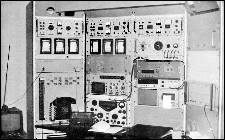
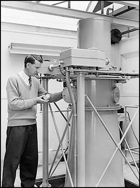
National time service equipment at Mount Stromlo circa 1972.
Image from Miller (1973).
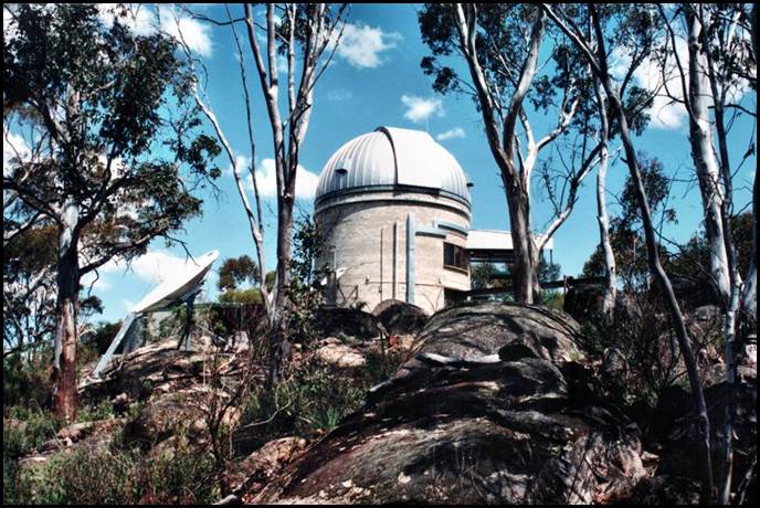
About the Mount Stromlo Photographic Zenith Tube (PZT) 1957-1985
Tenders were called in June 1954 for the construction of a timber and steel building to house the photographic zenith tube at Mount Stromlo. In 1955 it was reported that the PZT was being acquired from Grubb Parsons and Co of England. [The British telescope manufacturer Grubb Parsons was established in Heaton, Newcastle-upon-Tyne in 1925 as Sir Howard Grubb, Parsons & Co by Irishman Sir Howard Grubb (1844-1931) and Sir Charles Algernon Parsons (1854-1931). Grubb was an optical designer known for his work on optical telescopes and periscopes. Parsons, the son of an Irish earl, was an engineer known for his work on compound steam turbines. Grub Parsons ceased trading in 1985.]
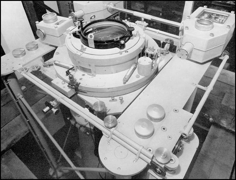
The Mount Stromlo photographic zenith tube optics undergoing testing at manufacturer Grubb Parsons’ Laboratory, England in 1954. Grubb Parsons image.
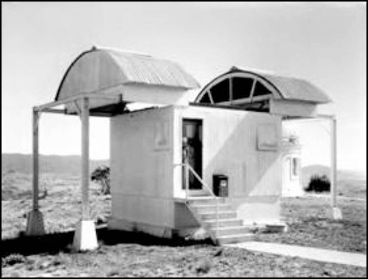
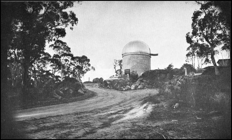
Mount Stromlo photographic zenith tube hut circa late 1950s.
Image from Mount Stromlo Observatory Archives in GML Heritage (2015).
The photographic zenith tube was brought into regular use at the Mount Stromlo Observatory around March-April 1957. At that time PZT observations provided the most precise means for determining the position of a point on the Earth's surface with respect to the celestial sphere at a given epoch. As the coordinates of the stars were known, the analysis of the zenith observations determined the angular rotation error of the Earth relative to that of a uniformly rotating body. As well, the changes in the angular distance between the instrument and the instantaneous pole of rotation were determined. These two quantities are more simply defined as the determination of Universal Time, and the Variation of Latitude.
The photographic zenith tube at Mount Stromlo was used by the Australian National University and Nat Map from 1957 to 1985 to monitor the Earth’s rotation and polar motion. The last PZT plate observed at Mount Stromlo was on 27 August 1985. In September 1985, Nat Map ceased operation of the PZT as by then the Lunar Laser Ranging system at the Orroral Valley Geodetic Observatory (in the Namadgi National Park about 60 kilometres south of Canberra) was producing superior results from laser ranging data from satellites.
An ANU staff member loading the glass plate holder into the photographic zenith tube at Mount Stromlo in 1962.
Image from National Archives Australia series A1200, control symbol L42631, Barcode 8832462.
Mount Stromlo PZT and Australian geodetic longitude
The photographic zenith tube at Mount Stromlo was used to define geodetic longitudes in Australia when the Australian Geodetic Datum adjustment (AGD66) was completed in May 1966. In 1982 a new national adjustment that improved the accuracy of the 1966 coordinate set was completed and later adopted as the Australian Geodetic Datum 1984 (AGD84). The 1982 adjustment incorporated all previous data and additional Doppler satellite observations and included geoid‑ellipsoid separation which was assumed to be zero in the 1966 adjustment (Manning, 2006).
In both AGD66 and AGD84, the reference meridian plane of zero longitude was defined as being parallel to the then Bureau International de l’Heure (International Bureau of Time) mean meridian plane near Greenwich. This in turn gave a value of 149° 00' 18.855" East for the plane contained by the vertical through the Mount Stromlo photographic zenith tube and the mean meridian plane near Greenwich (Murphy, 1986).
Nat Map’s Orroral Astro-Geodetic Observatory 1974-1998
Nat Map’s Orroral Observatory was established in 1974 under the terms of an October 1968 agreement signed between Australia and the United States for scientific and technical co-operation. This agreement was named the Hornig Treaty after Dr Donald Frederick Hornig (1920-2013) an American chemist, explosives expert, teacher and science advisor to president John Fitzgerald Kennedy. In March 1973 an agreement under the Hornig Treaty was signed between the Division of National Mapping and the United States National Aeronautics and Space Administration for co-operation on the construction of a lunar laser ranging facility in the Orroral Valley.
Nat Map’s Orroral Astro Geodetic Observatory circa mid-1970s.
Image from Pearlman (1977).
The brickwork for the observatory was built by Department of Works contractors. The double-brick cylindrical-shaped structure was 25 feet high with a 28.5 feet external diameter (Wise, 2019). The aluminium observatory dome was supplied by United States manufacturer Ash Dome. In 1974, this company’s sole representative, an American, was assisted by Nat Mappers Andy Rogers and Noel Templeman (1944-2009) to place the dome on top of the observatory structure.
The aluminium sheets for the dome were up to 30 feet in length and were ferried to the observatory site by Andy and Noel in a Nat Map RLCH model Bedford 4‑wheel drive truck. No crane was available for the dome installation and this 3-man crew used a scaffold to man-handle the dome sheets into position (Rogers, 2019).
In 1975, the Orroral Observatory saw the beginning of Nat Map’s lunar (and the later satellite) laser ranging program. This program commenced Nat Map’s use of laser ranging to measure distances from the Earth to the Moon and to orbiting artificial satellites. Laser ranging enabled calculations to be made on the changing shape of the Earth as well as monitoring changes in the Earth's rotation and the movement of tectonic plates (continental drift).
Nat Map’s Orroral Observatory in the 1980s.
XNatmap image from Dave Abreu.
National time service goes to Orroral 1974
After construction of the Orroral Geodetic Observatory was complete in October 1974 three caesium clocks from Mount Stromlo were installed at Orroral by the United States Naval Research Laboratory. Soon after, satellite time transfers commenced and provided sub-microsecond comparisons with the United States Naval Observatory in Washington DC and the Royal Observatory at Greenwich in London. In April 1977, Nat Map received an additional caesium clock on loan from the US Naval Research Laboratories. The clock ensemble at Orroral then consisted of four caesium and three rubidium standards.
One caesium clock was designated as the national primary standard of time and was maintained to keep Australian time accurate to 100 nanoseconds. Another caesium clock was portable and was used for national and international time transfers and to support Nat Map field survey operations. All seven of Nat Map’s atomic clocks were read and compared hourly by computer. Satellite time comparisons with the US Naval Observatory were also made by computer. (The caesium clocks were best for long-term time-keeping whereas the rubidium clocks were best for short-term time-keeping.)
In later years Nat Map’s time service included time transfers to and from other national and international time scales using Global Positioning System Satellites as well as occassional portable caesium portable clock trips.
In 1993, responsibility for civil time was assumed by the National Standards Commission, a Commonwealth statutory authority that was established in 1950 and subsequently operated under the National Measurement Act 1960. However, by arrangement with the Commission, Nat Map’s successor (the Australian Surveying and Land Information Group) maintained a defacto primary time standard from 1 January 1994.
The national physical standard, known as UTC (AUS), was kept by a small suitcase size Hewlett Packard 5071A cesium standard at the Orroral Observatory until 1 September 1998. Under agreement with the National Standards Commission, UTC (AUS) was maintained at all times to within 1 microsecond of the UTC kept by the Bureau international des poids et mesures (the Paris-based International Bureau of Weights and Measures).
Satellite laser ranging ceased at Orroral in October 1998 and some of the equipment was transferred to a new automated facility at Mount Stromlo. After the Orroral facility closed AUSLIG formally ceased any role in the keeping and dissemination of Australia’s time.
References
Allen, Philip George (2019), Personal communications.
Anonymous (undated), Phillip Thomas Woodger entry (1931) on the Riverside Cemetery Register; accessed from Queanbeyan-Palerang Regional Council website at: https://www.qprc.nsw.gov.au/Services/Cemeteries
Anonymous (undated A), Cecilia Mary Emily Woodger, 1959 Death Notice entry on the Ryerson Index; accessed at: http://ryersonindex.org/search.php
Anonymous (1946), Only survivor of Canberra for Capital Party Mr T E Woodger Looks Back, an article in The Canberra Times, Wednesday 27 March 1946, page 2; accessed from the National Library of Australia’s Trove search service at: https://trove.nla.gov.au/newspaper/article/2669800
Anonymous (1949), Henry Agnew Death Notice, in The Sydney Morning Herald, Wednesday 15 June 1949, page 24; accessed from the National Library of Australia’s Trove search service at: https://trove.nla.gov.au/newspaper/article/18119135
Anonymous (1949), Margret Adams Agnew Death Notice, in The Sydney Morning Herald, Wednesday 7 September 1949, page 24; accessed from the National Library of Australia’s Trove search service at: https://trove.nla.gov.au/newspaper/page/1029333
Anonymous (1961), Thomas Ernest Woodger Death Notice, in The Canberra Times, Wednesday 15 November 1961, page 18; accessed from the National Library of Australia’s Trove search service at: https://trove.nla.gov.au/newspaper/article/105899192
Anonymous (1991), Phil and Jean Woodger diamond wedding anniversary notice in The Canberra Times, Saturday 30 March 1991, page 19; accessed from the National Library of Australia’s Trove search service at: https://trove.nla.gov.au/newspaper/article/122352493
Anonymous (1994), Phillip Thomas Woodger Death Notice in The Canberra Times, Saturday 29 January 1994, page 78; accessed from the National Library of Australia’s Trove search service at: https://trove.nla.gov.au/newspaper/article/126925438
Anonymous (2009), John Robert Woodger Death Notice in The Canberra Times, Wednesday, 25 March 2009, page 20; email copy kindly provided by The Canberra Times Classifieds.
Australian Electoral Commission (1903-1980), Searches of various historical electoral rolls; accessed from the Ancestry website at: http://search.ancestry.com.au/search/
Bomford, Anthony Gerald (1967), The Geodetic Adjustment of Australia, 1963‑1966, an article in the Survey Review, Volume 19, No 144, April 1967, pages 52-71, accessed from the XNatmap website at : http://xnatmap.org/adnm/ops/prog/rafgeosvy/geodadj/geodadj.htm
Bell, Geoffrey David (2018), Catherine Ruth Weir (1874-1915) an entry on the Relatives of Geoffrey David Bell website accessed at: http://www.bellsite.id.au/gdbtree/HTMLFiles/HTMLFiles_15/P41024.html
Commonwealth of Australia (1967), John Robert Woodger appointment as Technical Officer, Grade 1 in the Department of National Development; promulgated in the Commonwealth of Australia Gazette, No 40, Thursday 4 May 1967, page 2227; accessed from the National Library of Australia’s Trove search service at: https://trove.nla.gov.au/newspaper/article/241039907/26094942
Commonwealth of Australia (1973) J R Woodger promotion to Technical Officer (Science), Grade 2 in the Positional Astronomy Section, Geodetic Branch, Division of National Mapping, Canberra promulgated in the Commonwealth of Australia Gazette, No 59, Thursday 24 May 1973, page 122; accessed from the National Library of Australia’s Trove search service at: https://trove.nla.gov.au/newspaper/article/241065692/26043245#
Commonwealth of Australia (1990), J R Woodger promotion to Senior Technical Officer (Science) Grade 1 in the Technical Facilities Unit, Policy and Information Services Branch, Australian Surveying and Land Information Group, Canberra; promulgated in the Commonwealth of Australia Gazette, Public Service No PS 9, Thursday 8 March 1990, page 1134; accessed from the National Library of Australia’s Trove search service at: https://trove.nla.gov.au/newspaper/article/244126707
Commonwealth of Australia (1999), John Robert Woodger, retirement as Technical Officer Level 4 on 29 January 1999 under Section 76W of the Public Service Act; promulgated in the Commonwealth of Australia Gazette, Public Service No PS 8, Thursday 25 February 1999, page 928; accessed from the National Library of Australia’s Trove search service at: https://trove.nla.gov.au/newspaper/article/244394238
GML Heritage (2015), The Mount Stromlo Observatory Precint: Heritage Management Plan-Volume 1; Report prepared for the Australian National University, July 2015; accessed from the Australian National University website at: https://services.anu.edu.au/files/document.../mount_stromlo_volume_1_july_2015.pdf
Horne, Colin James (1993), Colson, Edmund Albert (1881–1950), an entry in the Australian Dictionary of Biography, National Centre of Biography, Australian National University; accessed from the Australian National University website at: http://adb.anu.edu.au/biography/colson-edmund-albert-9798/text17319
Luck, John McKenzie (1983), Construction and Comparison of Atomic Time Scale Algorithms with a brief review of time and its dissemination, Technical Report 32, Division of National Mapping, Department of Resources and Energy, Canberra; accessed from the XNatmap website at: http://www.xnatmap.org/report_tdnm/time.pdf
Madigan, Cecil Thomas (1946), Crossing the Dead Heart, reprinted edition 1974, Rigby Limited, Adelaide. ISBN 0 85179 519 6.
Manning, John (2006) The Australian national geodetic survey, a paper presented to the 400 Years of Mapping Australia Conference, held in Darwin during 23‑25 August 2006, by the Mapping Sciences Institute Australia; published in conference proceedings as Paper 8; accessed from the XNatmap website at: http://www.xnatmap.org/adnm/conf_06_11/c06/aPaper%2008.pdf
Manning, John (2019), Personal communications.
McLean, Lawrence William (2019), Harry William Granger, an article on the XNatmap website, accessed at: http://www.xnatmap.org/adnm/people/aabout/Granger%20HW/HW%20Granger.htm
Miller, Malcolm John (1973), Photographic Zenith Tube Observations at Mount Stromlo, Technical Report 15, Division of National Mapping, Department of Minerals and Energy, Canberra; accessed from XNatmap website at: http://www.xnatmap.org/report_tdnm/pzt.pdf
Moseley, Kerrie-Ann (2019), Personal communications. (Ms Moseley is a staff member with The Canberra Times Classifieds.)
Murphy, Brian Anthony John (working party convenor) and others (1986), The Australian Geodetic Datum Technical Manual, National Mapping Council Special Publication 10, Canberra, ISBN 0 642 515476; accessed from the XNatmap website at: https://www.icsm.gov.au/sites/default/files/SpPub_10_AGD.pdf
Murphy, Brian Anthony John (2019), Personal communications.
National Archives of Australia (undated), Phillip Thomas Woodger Service Number - NX85276, World War II service record, Citation: NAA: B883, NX85276, Item Barcode 4614084; accessed from Service Record search on National Archives of Australia website at: http://www.naa.gov.au/collection/a-z/researching-war-service.aspx
Norwood Park Crematorium (undated), Memorial search for Woodger on Norwood Park Crematorium website; accessed at: https://www.norwoodpark.com.au/memorial-search/
Pearlman, Michael R (1977), Support of Lunar Laser Ranging System in Australia, Final Report I-January 1973 to 30 September 1976, prepared for the National Aeronautics and Space Administration Washington DC, March 1977, Smithsonian Institution Astrophysical Observatory, Cambridge, Massachusetts; accessed at: https://www.google.com/url?sa=t&rct=j&q=&esrc=s&source=web&cd=15&ved=2ahUKEwjet_HGjsziAhVWeH0KHSMQC-8QFjAOegQICBAC&url=https%3A%2F%2Fntrs.nasa.gov%2Farchive%2Fnasa%2Fcasi.ntrs.nasa.gov%2F19770075020.pdf&usg=AOvVaw2rNGUvHl-9KGsLqwJJdSt2
Registry of Births, Deaths and Marriages New South Wales (undated), Various Woodger marriage search results from Family History search from Department of Justice, Registry of Births, Deaths and Marriages website at: https://familyhistory.bdm.nsw.gov.au/lifelink/familyhistory/search/marriages?1
Rogers, Andrew (2019), Personal communications.
Sligo, Graeme (1997), The Development of the Australian Regular Army, 1944-1952, in The Second Fifty Years: The Australian Army 1947-1997, accessed from the Our History section of the Army website at: http://www.army.gov.au/~/media/Files/Our%20history/AAHU/Conference%20Papers%20and%20Images/1997/1997%20The%20Second%20Fifty%20Years%20The%20Australian%20Army%201947%20to%201997.pdf
Sloane, Barry James (2019), Personal communications.
Willington, Bruce Haley (2019), Personal communications.
Wise, Paul Joseph (2019), Personal communications.
Woodger, Anne (2019), Personal communications.