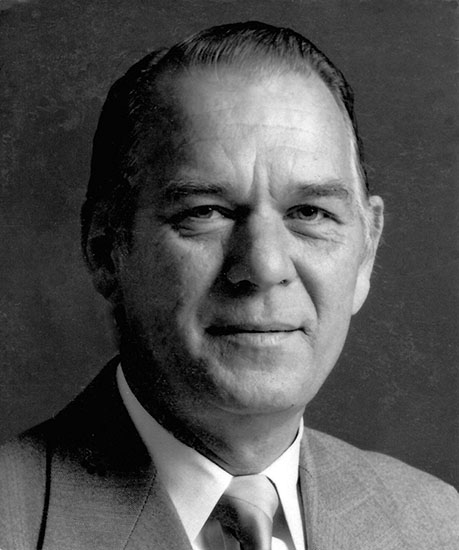
Len Turner (1932-2002): Nat Map’s Consistent Quiet Achiever
by Laurie McLean August 2014
Len Turner joined the Division of National Mapping in 1961 at the height of the Australian government’s post-war national development activities. This time frame was about a quarter of a century before the use of Global Positioning System satellites for navigation and precise position fixing. However, it was only seven years after the introduction to Australia of electronic methods rather than the surveyor’s chain for precise distance measuring. In the early 1960s and again in the early 1970s, Len Turner personally led the successful operational introduction of then world-leading technologies that achieved major milestones in Australia’s national mapping activities.
Len was held in the highest regard by Nat Mappers of all ranks who knew him or worked with him between 1961 and 1977. He is still recalled as a thorough gentleman who was known only to play things straight down the middle. Len is also recalled as perhaps the smartest man to have ever worked with Nat Map. Len’s considerable abilities as a surveyor and as a senior manager were quickly recognised. In his first five years at National Mapping’s Melbourne office he rose quickly through the professional ranks from Surveyor to Senior Surveyor and then to Supervising Surveyor. Len remained in Melbourne until 1971 when he took up a newly created position as an Assistant Director in Canberra. Here Len was responsible for creating and leading the Bathymetric Mapping Branch. Len Turner left National Mapping in 1977 with the intention of further advancing his career.
Of course Len Turner did not achieve all that he accomplished single handedly. During his time with Nat Map, Len Turner brought together some excellent field survey parties and helped to develop and nurture several outstanding surveyors who went on to become senior leaders within National Mapping. These people included Con Veenstra (Nat Map 1965-1987) who rose to become Nat Map’s Director; Syd Kirkby (Nat Map 1959-1984) who went on to become an Assistant Director; Peter O’Donnell (Nat Map 1968-1995) who also went on to become an Assistant Director; Rom Vassil (Nat Map 1965-1987) who rose to become a Supervising Surveyor; and Carl McMaster (Nat Map 1962-1993) who went on to become a Senior Surveyor and later the Manager of Nat Map’s Australian Centre for Remote Sensing).
Another outstanding Nat Map surveyor who worked with Len Turner in the field and in the office was Frank Leahy who joined in 1961. Frank had already obtained a Bachelor of Surveying degree and registration as a Licensed Surveyor. He left Nat Map in 1965 to pursue an academic career at The University of Melbourne where he rose to become a Professor and head of the then Department of Surveying.
Len was also held in high regard within the wider surveying and mapping community. He became a member of the Institution of Surveyors, Australia Victorian Division in 1968. Len transferred to the Institution’s Canberra Division in the early 1970s and served a term as that division’s president in the mid-1970s. Len was also a member of the Australian Institute of Cartographers. Len presented technical papers on new developments in surveying and mapping at national and international conferences. (Known papers presented by Len are listed in the references below.)
Len Turner was essentially the quiet achiever. Con Veenstra once remarked that Len could be typified as achievement without fanfare because of his quiet and unassuming application of his considerable abilities. Despite his outstanding achievements as a senior manager and in implementing some of the biggest mapping field projects ever undertaken in Australia (certainly in terms of area covered and complexity of technologies deployed), Len Turner’s contributions to Australia’s development have received scant acknowledgement and little formal recognition. Syd Kirkby reflected that Len Turner was a most decent man and one with whom Syd enjoyed many games of chess. Syd was surprised that Len’s ability and decency were not more materially rewarded in his later career. Peter Langhorne (Nat Map 1966-1969 and 1972-1979) worked in close proximity to Len Turner in the Department of National Resources' central office in Canberra during the latter part of the 1970s and the early 1980s. Here Peter found Len to be a person with the attributes that we would all like to have: intelligent, hard working, likeable, a good people manager and supportive of other staff members. Peter recalled that Len performed very well in this policy environment and his performance was recognised at the highest levels. However, Peter remembered that Len was up against stiff competition when it came to getting into the then Second Division of the public service. Peter also recalled that in those days perhaps too much promotion assessment emphasis was being placed on younger candidates with higher academic qualifications rather than on officers such as Len Turner who had a wealth of experience and a sound track record of outstanding achievements.
This article seeks to redress the above mentioned recognition anomaly and to document some of the milestones and achievements in Len Turner’s life and professional career. Readers are warned, however, that this article discusses Len Turner primarily from a Nat Map perspective. Thus the article is mainly about Len’s professional life rather than his personal life. Accordingly little mention is made of Len Turner the family man who was much loved and is sadly missed by his older sister Catherine, by with wife of over 40 years Kath and by his children Tim, Dianne and Michelle.
In what follows it may be gleaned that still waters do indeed run deep and the quiet, calm and gentlemanly achiever that many Nat Mappers came to know, respect and admire was to a large extent a driven man. It seems that Len Turner was constantly seeking new challenges and always striving to further his work experiences and raise himself to a higher level of achievement. Clearly he had considerable fortitude and self-belief and took on personal professional challenges that many may have found daunting.
Some Nat Mappers’ Recollections
John Ely (Nat Map 1965-1990) recalled that on his Aerodist field visits as Supervising Surveyor in the late 1960s, Len always impressed staff with his gentle demeanour and with his considerable knowledge of the technical aspects of the system’s electronics. As an Aerodist technician John remembered that Len was very astute and had an almost uncanny ability to ask the questions about equipment serviceability and performance that John would have preferred not to have to answer!
Kevin Burke (Nat Map 1962-1965) recalled Len Turner as a consistent leader who ran his field survey parties as stress free as was possible. Len had no favourites amongst party members nor did he ever have anybody in the gun. Kevin remembered working under Len in a field party carrying out astro-fixes in Western Australia during 1964. (Astronomical determinations were an early means of obtaining coordinates for horizontal mapping control and the field parties usually also undertook barometric heighting for vertical control.)
Kevin recalled the 1964 field party travelled from near Wiluna and along the abandoned No 1 Rabbit Proof Fence east of Nullagine and then worked with helicopter support further east into the Great Sandy Desert and later south to Lake Carnegie. Len Turner flew into Port Hedland where one of the party members met him for the drive to Roy Hill and then into the Great Sandy. The party had two AB120 International trucks and a heavier RLCH Bedford. As well as Len and Kevin, other members of the field party included Richard Carter, Andy Lukas, Terry Douglas and Don Locke who drove the Bedford. Helicopter Utilities Pty Ltd provided a Hughes 269 (2-seat) helicopter which was piloted by Jack Palmer. Kevin (who was a qualified radio and television technician) also worked with Len Turner and others on Aerodist measuring operations.
Terry Douglas (Nat Map 1961-1971) recalled first working with Len Turner in 1962 on a short field trip to central Queensland. With their survey levelling equipment, Len and Terry flew from Melbourne to Brisbane where they boarded the train to Rockhampton and from there took another train to their destination of Alpha, about 435 kilometres west of Rockhampton. At Alpha, they levelled from a benchmark at the railway station near the corner of Scott and Shakespeare Streets and then west along the Capricorn Highway to the airstrip; a one-way distance of about six kilometres. (However, as a check against error, the levelling would have been done out to the airstrip and then back to the bench mark.) Presumably the purpose of the levelling was to obtain the height of the airstrip for aeronautical charting.
Terry Douglas also recalled working again with Len Turner later in 1962. One task that year was to carry out a reconnaissance to establish a survey control station mark on Mount William in the Eungella National Park to the west of Mackay. It was a fairly arduous task. Covered with tropical rainforest, Mt William rises to some 1,259 metres above sea level and is located about 15 kilometres north of the village of Finch Hatton. It took Len and Terry a couple of days to establish and mark an access track to the top of Mt William. Carl McMaster recalled subsequently establishing the survey mark on Mt William in 1963 with Terry Douglas and Jacques de Stefani and still has memories of struggling to the summit with the metal beacon vanes under his arm while Terry and Jacques dragged the heavy centre pole. Other party members included Frank Leahy, Neil Fenton, Alan Osborne and Kevin Burke. Carl remembered being warned of a python near their survey camp in the rainforest at the foot of Mt William.
Carl McMaster also recalled that the 1963 work on Mt William was part of a second order Tellurometer traverse to the Staircase Range between Springsure and Rolleston about 360 kilometres to the south. The traverse included several intermediate stations and was commenced a year earlier by a field party that had included at various times Len Turner, Frank Leahy, Kevin Burke, Don Locke, Brian Daenke, Andy Lucas and Terry Douglas. Carl also remembered working on the traverse with Frank Leahy out of Clermont in 1962 when they used the then new model MRA2 Tellurometers.
Rom Vassil remembered Len Turner as a very gentlemanly person and recalled working with Len for a few days in June 1966. Len joined the Aerodist station ground marking field party that also included Graeme Harris, Ross Gray and Alan Mould at Theodore on Friday 24 June 1966. (Carl McMaster later joined the field party and recalled that Terry Douglas was also there.) The next day Len and Rom undertook an area reconnaissance for the site of an Aerodist station (NM/B/213) that was to be established about 48 kilometres west of Moura. Len and Rom returned to Theodore that evening where they met up with Syd Kirkby and Con Veenstra. On the Monday, Len and Rom returned to the NM/B/213 area and selected the site for this new station about 50 kilometres west of Moura. Later that day they continued on to the south-east of Thangool where the site for new Aerodist station NM/B/214 was selected. Rom recalled that Len left the field party on Tuesday 28 June 1966.
Paul Wise (Nat Map 1969-1999) recalled that Len Turner was the Division of National Mapping’s representative on the then Commonwealth Public Service Board panel that recruited cadet surveyors for training and development and later service with Nat Map in 1968. Paul appreciated the cadetship process with which Len was involved that year. It resulted in Paul Wise and Bob Cross becoming cadet surveyors in 1969. Both Paul and Bob went on to have rewarding professional careers with Nat Map and in Paul’s case a career that spanned some 30 years.
Family Background
Leonard George Turner was born on 5 January 1932 at Pahiatua a small town in the Wiararapa district towards the east coast of New Zealand’s North Island. Pahiatua is situated to the south-east of Palmerston North and about 130 kilometres north of Wellington. Len was the second of three children born to William John Turner and his wife Cora Georgina (nee Boyens). Len’s siblings were his older sister Catherine (born in 1928) and his younger brother Alan Ratcliffe (born in 1939). Len also had two older half-brothers from his mother’s earlier marriage to Wilfred Benton who died suddenly of cancer before his youngest son was born. Len’s half-brothers were Donald (born 1919) and Ivan (born 1921). Both Donald and Ivan served in World War II.
Len’s paternal grandparents were George Turner and his wife Catherine (nee Ratcliffe). George and Catherine and some of their children immigrated to New Zealand. There they took up some virgin country for dairy farming in the Hukanui district near Pahiatua. Len’s father William was youngest of the family’s nine children; two of which did not survive childhood. William Turner and his brother Bert served in World War I.
Len’s maternal grandparents were William Henry Boyens and his second wife Elizabeth Dermott. Len’s mother Cora Georgina was one of the five children of this marriage. Cora also had three half-brothers and a half-sister from her father’s earlier marriage to a sister of Elizabeth who had died leaving the four young children who Elizabeth cared for as a housekeeper before she married William. Len’s grandfather William Henry Boyens was a mechanical engineer who moved from Kaikoura on New Zealand’s South Island to Pahiatua to take up a position at the cheese factory.
From age three years Len grew up on the 30-acre dairy farm that his parents had recently bought at Ihakara; about six kilometres north of Levin on the road to Palmerston North. Here the family milked 23 cows and also raised pigs and grew crops for stock feed.
Schooling
Len started his school years at the small nearby Ihakara School that took children up to Grade 3 level. Len later completed his primary schooling at Levin. In 1944 Len commenced high school at Horowhenua College in Weraroa Road Levin. At high school Len played cricket as wicketkeeper and opening batsman as well as rugby union and tennis. However, he conceded that he was not a particularly diligent student. Len left school at age 14 at the end of the 1946 school year. He had just gained his School Certificate after completing three years at high school.
Grocery Assistant
Soon after he left school Len started in the paid workforce as an assistant in the storeroom of the local grocery store at Levin and later graduated to serving customers and helping with occasional deliveries in the store’s van. Len enjoyed his time at the grocery store and appreciated the opportunity it afforded for him to learn to drive prior to being old enough to obtain a driver licence. Len used to ride his bicycle to work from the farm at Ihakara. Riding home one day he noticed a man looking at the countryside through a telescope and stopped to ask him what he was doing. Stuart Foster was the man and he explained that he was surveying for a land subdivision. Len decided there and then that he would like to pursue a career in surveying.
Cadet Surveyor
Soon afterwards Len was interviewed by Stuart’s father, Charles Foster who offered to put Len on a six-month trial period. Len commenced his surveying career in 1948 at age 16 years. He came through the initial trial period successfully. Afterwards he was articled to Charles Foster as a cadet surveyor. Len started work as a chainman for both Charles Foster and his son Stuart (who qualified as a surveyor soon after Len started). For the next four years Len was involved in doing his surveying articles and undertaking correspondence classes. At that time there were only limited opportunities to obtain a degree in surveying in New Zealand which as in Australia generally used the British articles model to train surveyors.
To pass the examinations required by the Survey Board of New Zealand to be registered as surveyor, Len studied through correspondence classes with the Wellington Technical College. Each year he travelled to Wellington to sit examinations in the subjects he had studied. Len managed most of the exams he had to sit reasonably well but had trouble with astronomy and photogrammetry. Neither of those two aspects of surveying was used in the Fosters’ practice and they were completely new to Len. Len apparently enjoyed the practical side of the work which consisted mainly of residential subdivision surveys and some boundary redefinitions. He was soon carrying out simple surveys himself.
Charles Foster carried on his survey practice from his home that was located about half way between the Turner family farm and Levin. (A land surveying and property development firm Foster and Company still operates from premises in Oxford Street Levin.) The Fosters also had a fairly extensive nursery. Charles Foster’s son-in-law worked the nursery while Mrs Foster concentrated on growing hothouse orchids and asparagus. The Fosters’ survey practice covered an area from about 50 kilometres south of Levin to Foxton about 16 kilometres to the north-west and past the town of Shannon about the same distance to the north. The Horowhenua area covered by the practice extended to the coast in the west and to the Tararua Range in the east. Thus the Fosters had quite a large catchment as the only survey firm at that time between Wellington and Palmerston North. (Fortunately, in the five years that Len worked there he only had one job in the foothills of the Tararua Range. The range rises quite sharply from the alluvial flats and had no vehicle access which meant the surveyors had to carry all their survey gear on foot to the work sites.)
National Service
In 1951, soon after Len reached 19 years of age he was called up for compulsory military service in the first intake of a scheme introduced under New Zealand’s Military Training Act 1949. Len served in the Royal New Zealand Artillery and was promoted Bombardier in the early part of his initial 14 weeks of training. During later two-week annual camps Len was promoted to Second Lieutenant and later to First Lieutenant. However, Len decided to complete his surveying cadetship rather than pursue a military career.
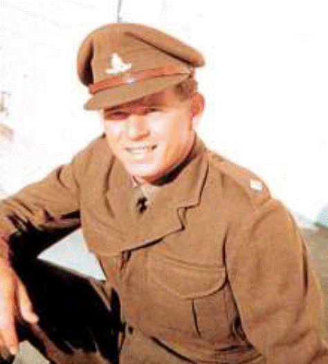
Second Lieutenant LG Turner circa 1952.
Registered Surveyor
In July 1952, Len completed his surveying cadetship and continued to work for the Fosters as an assistant surveyor. By March 1953 he had passed the last of his written examinations in the thirteen subjects to be studied and submitted the necessary practical work. Len had also passed a practical test in astronomy conducted in Wellington under the supervision of a Survey Board of New Zealand representative. This test was passed despite Len’s observations of the sun and subsequent calculation of latitude placing Wellington somewhere just inside the Antarctic Circle! The examiner said that he could see that Len knew what he was doing so decided to give him a pass. What the examiner did know was that it was the first time Len had ever attempted an astronomical observation of that type. Thus in 1953, at age 21 years Len was issued with a Certificate of Competency by the examining authority and shortly after received a Certificate of Registration from the Survey Board of New Zealand which entitled him to undertake cadastral surveys in his own right as a Licensed Surveyor.
New Hebrides with the Colonial Service 1953-1954
Rather than commit to the life of a rural surveyor at Levin, Len decided to look for work overseas. The first of Len’s several overseas surveying appointments was with the Condominium of New Hebrides. (Now known as a Vanuatu, this group of South Pacific islands was then simultaneously administered by three separate governments, namely British, French and a joint administration.) Len commenced what was intended to be a three-year assignment as a qualified surveyor with the British Colonial Service at Port Vila.
In New Zealand in 1953, prospective appointees to the Colonial Service had to be interviewed by the representative of Her Majesty’s government. Thus Len Turner then a 21-year old country surveyor from Levin found himself at the imposing Edwardian era Government House in Wellington. He was ushered in to the presence of His Excellency New Zealand’s eighth Governor General by the aide-de-camp in the full dress uniform of an officer of the Royal Air Force. His Excellency was Lieutenant-General Sir Charles Willoughby Moke Norrie GCMG, GCVO, CB, DSO, MC (and Bar); later Lord Norrie (1893-1977). Fortunately, Len found him to be a kindly man who asked only a few simple questions, wished him luck and then shook his hand.
In July 1953, Len travelled to Sydney on the trans-Tasman ferry MV Wanganella and the next day flew from Rose Bay to Port Vila in a Sunderland flying boat. In those days there was no airport at Port Vila nor was there a jetty for the flying boat so passengers were taken ashore by lighter. At Port Vila Len nominally reported to the chief engineer in the Works Department as the chief surveyor was on furlough. Unfortunately Len found that the overly bureaucratic administrative arrangements in the Condominium mitigated against efficiency and that there was no meaningful work to be done. Thus in March 1954 Len was back in Sydney.
Surveying in Australia 1954-1955
Later Len moved to Melbourne where he spent about three months working as a chainman with Victorian Department of Lands and Survey surveyor John Douglas Sherwood pending the take up of a position in Darwin. In July 1954, Len joined the Survey Branch of the Lands Department in Darwin. The Department was in the then Northern Territory Administration (that administered the Territory on behalf of the commonwealth until self government in 1978). Here Len worked with Chief Surveyor Allan James and his son Earl as well as another surveyor Reg Wilson. Len’s assignments included the subdivision of a wartime airstrip at Fanny Bay and a levelling survey on the Adelaide River flats at Humpty Doo for an experimental rice growing project.
In April 1955, Len joined the Northern Australian Uranium Company that was developing a uranium prospect and carrying out exploration in the upper Katherine River area. The company’s Sleisbeck mine was located about 100 kilometres east of Pine Creek (at about 13 degrees 46 minutes South and 132 degrees 50 minutes East).
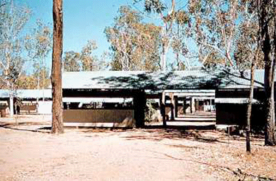
Miners’ quarters at Sleisbeck, Northern Territory in 1955.
At Sleisbeck Len operated from a fairly comfortable but isolated camp that was reached by aircraft. The camp had well constructed buildings and staff members were well catered for. Here Len carried out various exploration surveys and set-outs. It was while at the Sleisbeck camp that Len first met Nat Map surveyor Joe Lines who was carrying out astro-fixes in the East Alligator River area. Len left Sleisbeck in October 1955 and had a fairly leisurely trip back to his family home in New Zealand for Christmas.
Seismic line surveys New Zealand 1956-1957
In February 1956, Len joined an oil exploration joint venture between the New Zealand firm Todd Energy, the Shell Petroleum Mining Company Ltd and the BP Oil Exploration Company. Here Len pegged out seismic lines for oil exploration under the shadow of Mt Egmont in the Taranaki dairy farming area on the west coast of New Zealand’s North Island about 30 kilometres south of New Plymouth. (In 1959, a few years after Len had left the joint venture the Kapuni field was found to be rich in gas and condensate.)
Marriage to Jan Smart 1957
Around Christmas 1956, Len met Jan Smart who was the daughter of a Methodist minister in Napier and his wife. Len and Jan married in 1957 at New Plymouth. Sadly Jan could not sustain Len’s long absences away from home on field duty in New Zealand and later in Dutch New Guinea. In 1958, Len and Jan decided to go their separate ways. At the time of their separation both were stationed at Sorong in Dutch New Guinea. Jan then returned alone to New Zealand and Len and Jan divorced at Wellington in 1960.
Assignments in New Guinea and Nigeria with the Shell Group 1958-1960
At the end of 1957, Len joined the expatriate staff of the (Anglo-Dutch) Royal Dutch Shell Group and flew to Europe to spend some weeks at the Shell offices in Holland and England. At the former office he spent some weeks learning conversational Indonesian with a private tutor.
Afterwards Len flew via Jakarta to the coastal city of Sorong on Birds Head Peninsula (Vogelkop) at the far western end of the then Dutch New Guinea (now the Indonesian province of Western New Guinea). From his base at Sorong Len carried out three separate survey projects.
The first project was a gravity survey from a camp with accommodation on a house boat on the Eilanden River over 900 kilometres south-east of Sorong. Len flew to the survey camp in a Catalina flying boat. The survey involved taking gravity readings and water depths at various points along the river that Len would mark on a photo map. To do this work Len travelled in a Canadian style canoe with an outboard motor.
Len’s next assignment was from a survey camp on the Vogelkop about 200 kilometres south-east of Sorong. The camp was on a river bank and Len was again accommodated on a house boat. Access to the camp was by Bell 47G light helicopters which allowed Len to come back to Sorong about every three weeks. The work was similar to the previous project except being on dry land. Local workers had to cut straight lines (called rintises) through the jungle at about one-kilometre intervals with tie lines crossing these at about every five kilometres. The gravity measurements were taken by local observers at these intersections and at other stations along the rintises. Len’s role was largely supervisory and included plotting the observers’ results.
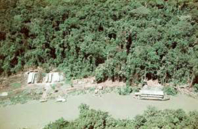
Len Turner’s Vogelkop survey camp Dutch New Guinea 1958.
Lens’s last assignment in New Guinea was based from the small village of Sarmi on the north coast about 800 kilometres east of Sorong. Len travelled from Sorong to Sarmi via the coastal city of Manokwari in a comfortable freighter; the MV Kaloekoe. Here the survey and geophysical party built their own accommodation in the form of a low set tropical house. Len was stationed at Sarmi for about three months while he carried out further land based gravity surveys.
After about a year in New Guinea, Len was granted leave. He flew via Port Moresby to Melbourne where he stayed with his sister Cath for a few days and then spent a few weeks back in New Zealand. After his leave Len was requested to report to the Shell office in London. While in London Len spent some time at the Shell head office and also undertook a course in the maintenance of echo sounding equipment at the factory of the long established equipment and technology company Kelvin Hughes Limited.
Len’s next assignment was in Nigeria and he flew from London to Lagos and then on to Port Harcourt in the Niger Delta. The Delta is a densely populated area of some 70,000 square kilometres running inland from the Gulf of Guinea on Africa’s west coast. From Port Harcourt Len travelled downstream about 50 kilometres by small boat to the town of Bonny at the mouth of the Bonny River where he was stationed. The town dated from the Fifteenth Century Kingdom of Bonny trading centre.
Len was in Nigeria during a time of considerable development and change. The Shell Company had begun oil production from fields linked to its Port Harcourt shipping terminal facility in 1958. Owing to high silt loads in the Bonny River there was an ongoing dredging operation to keep the shipping channels at the mouth of the river open. Len carried out soundings of the river bed at its mouth to determine the amount of spoil being removed and thus the payments to the dredge operators and also to ensure there was sufficient water depth for the oil tankers. Before leaving Bonny, Len also carried out a locality survey on a spit of land that was becoming permanent on one side of the Bonny River.
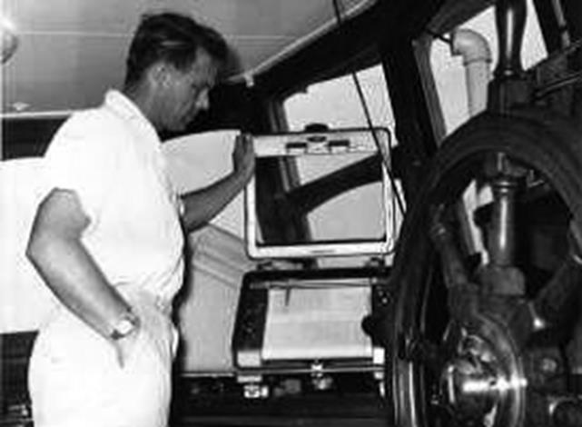
Len Turner checking a soundings chart on a survey vessel in Nigeria 1960.
Afterwards Len was based from Port Harcourt from where he carried out small scale hydrographic surveys in various rivers that formed the Niger Delta. These surveys were to establish routes where oil drilling rigs could be towed on barges and also to locate sites were stanchions could be dropped into the rivers to stabilise the rigs during drilling operations. During most of this period Len was accommodated on a houseboat. By June 1960 Len had decided it was time to move on and so he travelled back to New Zealand via South Africa and Sydney. (Nigeria achieved independence from Great Britain on 1 October 1960.)
Practice Manager Foster and Foster Wellington 1960
After Len’s return to Levin he was looking for work and was pleased when his old boss Charles Foster said he would be happy to re-employ him. By that time Charles’ son Stuart was running the practice and had opened an office in Wellington to expand the business. Stuart Foster offered Len the job of managing the Wellington office which Len apparently jumped at and went on to work in Wellington for the rest of that year. However, after the break for Christmas 1960 Len again felt restless. He then decided he would go back to Australia. Stuart Foster apparently thought that Len must have been in the tropics too long but graciously accepted his resignation and Len travelled back to Australia on the MV Wanganella in February 1961.
Marriage to Kath Grewar 1961
Len married Kathleen Vallantyne Grewar on 23 August 1961 at a Methodist Church in the Melbourne suburb of Toorak; the Reverend Freeman officiated. Len had first met Kath in Darwin in the early 1950s and they became engaged in April 1961. (Kath’s parents lived at Frankston.) Len’s friend and fellow surveyor from the Northern Territory Administration days, Earl James was best man at the wedding. (In 1994, Earl Bruester McDonald James was awarded the honour of Member of the Order of Australia for his service to surveying, local government and the community.) Len and Kath Turner were to have three children: son Timothy Leonard (born in 1962) and daughters Dianne (born in 1964) and Michelle (born in 1966).
Soon after their marriage, Len and Kath rented flats at Surrey Hills and later at Seaford while their own home at 30 Tara Drive Frankston was being built. Afterwards as their family grew the Turners built a new home at 99 Overport Road Frankston near the bayside village of Mt Eliza about 45 kilometres south-east of the Melbourne city centre. Here Kath was to become active in the nearby Derinya primary school that their son Tim attended from 1968.
National Mapping Melbourne 1961-1971
Len Turner had moved to Melbourne in early 1961 primarily to facilitate his courtship of Kath Grewar. Len also needed employment so he could maintain his intended bride. An approach to the Department of Interior was unsuccessful but did yield the advice that he should try for a job at National Mapping. Later, sometime after early April 1961, Len called on the receptionist on the second floor at the commonwealth government’s Division of National Mapping’s Melbourne office in the Rialto Building at 497 Collins Street. He said he was seeking employment as a surveyor. The receptionist said she would find someone suitable to talk with Len; it was Joe Lines who Len had met at the Sleisbeck mine about six years previously. Apparently Joe remembered their earlier meeting and straight away agreed to take Len on as a temporary topographic surveyor. Thus Len embarked on a 17-year career with Nat Map.
Appreciating Len’s personal circumstances Joe Lines took him under his wing and arranged for Len to spend the rest of 1961 in the Rialto office. Here Len had the opportunity to study photogrammetric mapping procedures of which he had had only limited knowledge. Len also started looking at survey control acquisition systems as Nat Map realised that the astro-fix method would not be sufficient for the proposed future 1:100,000 scale national mapping program.
In 1961, Nat Map received funding to purchase an Aerodist system derived from the South African invention called a Tellurometer that was a ground-based microwave electronic distance measuring technology that needed line of sight along the line being measured between survey points. The Tellurometer was then being successfully employed by Nat Map to establish a precise point-to-point geodetic framework on the ground across Australia.
To correctly plot topographic detail from the vertical aerial photography then being flown across the whole country many minor control points had to be established. The Aerodist was an airborne version of the Tellurometer technology that overcame the line of sight constraint of the ground based Tellurometer. The ground based method necessarily reduced the lengths of lines that could be measured and also impacted on control station site selection options. The Aerodist system operated with about 2-4 watts of radiated power in a radio frequency band of 1215-1400 megahertz.
After about six months with Nat Map Len was promoted Senior Surveyor. As indicated in the Reflections section above, Len Turner commenced field work activities with Nat Map in 1962. This was in the second half of the year after the initial set of Aerodist equipment had been received but failed acceptance testing. (In July 1962, the Aerodist equipment was returned to the supplier and later shipped back to South Africa for modifications.) Later in 1962, to meet the need for some photogrammetric control, Len led a field party to central Queensland to do some Tellurometer traversing in the Clermont-Emerald area. As mentioned earlier, he also undertook some levelling at Alpha.
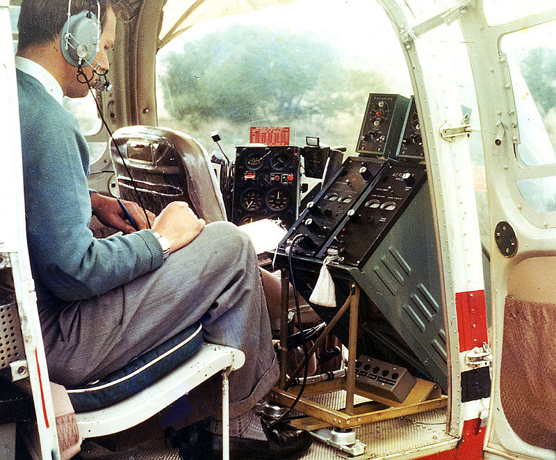
Len Turner circa 1963 ground-testing the Aerodist master units mounted in Ansett-ANA’s Bell 47J-2 helicopter (VH-INM).
The Aerodist system
Len Turner personally carried the operational introduction of the Aerodist airborne microwave distance measuring system. Between 1963 and 1974 Aerodist was used by National Mapping to obtain horizontal control for 1:100, 000 scale topographic mapping over about 50 per cent of Australia’s mainland area. In his 1992 book, Australia on Paper: The Story of Australian Mapping, Joe Lines (Nat Map 1948-1976) recorded that Len Turner...did so much to mould the Aerodist technique into a highly efficient form of airborne surveying. (Coming from Joe Lines this is considerable praise indeed from a man not known for giving such concessions either lightly or frequently.)
Nat Map’s Aerodist operation was a multi-million dollar program with a field component that comprised at times around 15-20 personnel with motor vehicle and aircraft support including both fixed-wing aeroplanes and helicopters. Off-shore Aerodist measuring also involved various motor vessels and at times Royal Australian Navy ships. The measurement signals from the two ground stations at either end of an Aerodist line were recorded simultaneously on an analogue paper chart in the measuring aircraft. Consequently, there was also a considerable office component involved in measurement reductions and computing as well as field planning, preparation and general support.
As well as conducting the acceptance testing of the equipment and leading its initial field use Len Turner drove the development of the early Aerodist computation program in the Rialto office. Carl McMaster recalled working with a team of manual chart breakers while Rom Vassil trialled an automated chart reader albeit with limited success.
Aerodist field work commenced in 1963 and the 1964 field season started at Dalby in late April and ended at Bourke in late August. For most of 1964 the field party was led by Syd Kirkby. When back at the Rialto office at the end of his 1964 Aerodist field involvement, Len had the opportunity to develop the necessary computing capacity to cope with the calculations needed to establish the latitude and longitude of the Aerodist ground stations from the intersecting distance measurements. To this end he learnt about FORTRAN programming, punched paper tapes and card reading computers. At this time Nat Map’s geodetic survey observations were being computed in Canberra by people under Tony Bomford’s (Nat Map 1961-1982) guidance. They were using a sophisticated least squares adjustment method which Len saw as a means of reducing the data from Aerodist measurements. Consequently the Aerodist data reduction staff became involved with the computing division of the Commonwealth Scientific and Industrial Research Organisation. At that time CSIRO was undertaking all of the computing needed by the commonwealth government.
The primary Aerodist point-to-point distance reduction software was written by Frank Leahy who started this task when he worked with Nat Map (1961-1965). Frank continued working on the software under contract after he took up a post at The University of Melbourne. Carl McMaster had a major hands-on role in the reduction of field measurement results. Carl recalled that Aerodist computations were processed on the Commonwealth Scientific and Industrial Research Organisation’s Control Data Corporation 3200 computer at the David Rivett Laboratories at the Monash University’s Clayton campus and later on a CDC 3600 computer at the CSIRO’s computing centre in East Melbourne.
Aerodist Operations
In July 1962, Nat Map took delivery of its initial set of Aerodist equipment but as mentioned previously this set failed acceptance tests and Len Turner arranged for it to be returned to the supplier. In January 1963, a second set was delivered and later accepted. The acceptance followed from a series of ground-based and helicopter-borne tests that Len Turner conducted in the area to the west of Melbourne between April and early June 1963. This second Aerodist set comprised a master control unit (Red frequency code) and an ancillary master unit (that had a separate Blue measuring frequency code).
The Aerodist master units had related sub-systems to record distance measurement readings on integrated analogue paper charts and also for separately gathering meteorological and other data. The system also included four ground-based remote units (Red 1, Red 2, Blue 1 and Blue 2). One of these units would be operated from a survey station at either end of a line that was then measured by the aircraft flying between the two remote stations.
During the early years of Aerodist operations, Nat Map expanded and modified system components to include three master measuring channel frequencies; a White frequency master unit was added in 1964 and an extra (White frequency) remote also added for the 1964 field season. Later some dual frequency remote units were added. In field operations there were two main organisational components: the centre party that operated the master measuring equipment in the aircraft and the two-person remote sub-parties that operated remote units on the ground at survey control stations.
As mentioned previously, field use of the Aerodist system commenced in 1963 with helicopter-borne operations in a Bell 47J-2 Ranger (VH-INZ) chartered from Ansett-ANA. After an unsuccessful attempted start at Dalby on Queensland’s Darling Downs, initial measuring operations were carried out in the Gayndah-Mundubbera-Eidsvold area of central Queensland. Len Turner led this initial measuring operation with Syd Kirkby as second in charge. As mentioned earlier, Carl McMaster recalled that Len Turner was the initial Aerodist field party leader for helicopter borne measuring operations that were again based from Dalby in early 1964; later that year Syd Kirkby took over as field party leader.
As measuring operations became more routine, the helicopter’s slower speed and limited endurance became a constraint. Thus for the 1965 measuring field season the master units were mounted in a Rockwell Aero Commander 680E fixed-wing aircraft (VH-EXY) chartered from Executive Air Services Pty Ltd based at Melbourne’s Essendon airport. Between 1966 and 1974, a larger Rockwell Grand Commander 680FL aircraft (VH-EXZ) was used. It was also chartered from Executive Air Services. The last Aerodist line was flown with aircraft VH-EXZ operating out of Derby in Western Australia on 2 November 1974; senior surveyor Peter Langhorne was the party leader.
Aerodist flying operations were fairly complex. Prior to undertaking an Aerodist measuring flight, the four separate two-man ground parties with microwave remote transponder units would be positioned at survey control marks; in the more remote areas this positioning was done by helicopter. In a simplistic configuration the survey marks would be at the four corners of a quadrilateral that was one degree of longitude wide and one degree of longitude deep with each corner being close to the intersections of degree meridians and parallels. (Later there were a further two remote transponders that were usually deployed on an ad hoc basis as necessary to extend operational measuring capacity.)
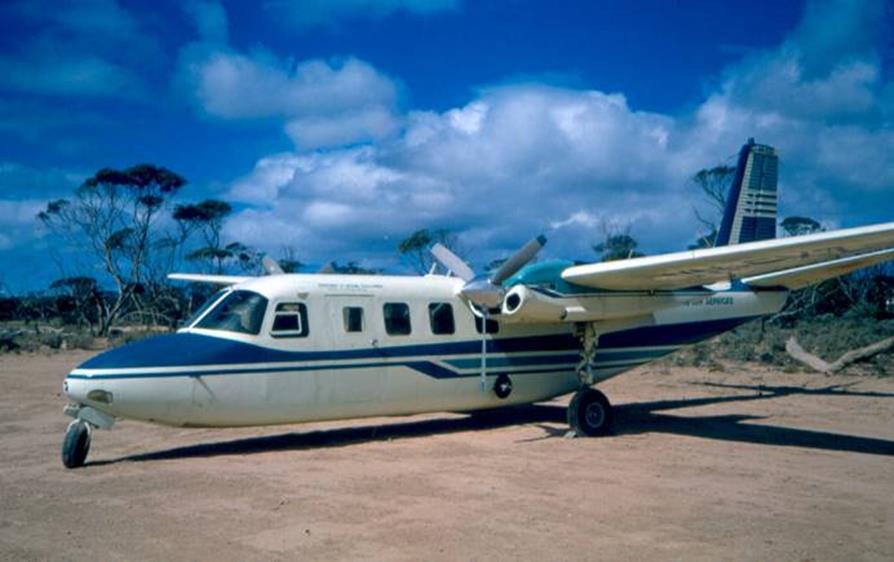
The Rockwell Grand Commander 680FL (VH-EXZ) was used for Nat Map’s Aerodist operations from 1966-1974. It is seen here at Caiguna WA in 1972.
Such a nominal ground configuration would thus yield six unknown distances or Aerodist lines to be measured, namely the four lines along the sides of the quad (each about 60 miles long) and the two diagonals that braced the quad each about 80 miles long. The measuring aircraft usually had two Nat Map operators on board and the pilot would fly the aircraft at an oblique angle through each line roughly at its centre so the line could be measured by the on‑board Aerodist master measuring equipment interrogating return signals from the ground transponders.
For each Aerodist line being measured there would be a minimum of seven good runs with the goodness of the measurement being determined by the quality of the traces on the automated recording chart. Each measuring run would start at about 7,000 metres on the approach side of the actual line crossing point and continue for a similar distance on the departure side of the crossing. The aircraft would then come around and start the next run. During each run the pilot had to strictly maintain aircraft height and heading to optimise the measurement. Of course sometimes more than seven runs were needed to obtain the necessary good measurements.
Usually the first run across a line was the most difficult as the master operator would give height, heading and even aircraft positioning corrections to the pilot to get the best simultaneous return signals from the two ground station transponders. Generally the aircraft flying height was 5,000 feet above sea level but if necessary due to weak signal strength such as on the longer lines in the Coral Sea surveys the aircraft would fly higher; even to 13,000 feet above sea level. After completing a minimum of seven good measuring runs on an Aerodist line, the aircraft would ferry to the next line crossing point and start the procedure again.
Once an initial measuring quad configuration (as in the example above) was completed the aircraft would return to base while the ground parties were repositioned for the next day’s measuring operations. To some extent day-to-day Aerodist operations were like playing chess across Australia’s remote interior or off-shore territories. As mentioned above, from 1966-1974, the measuring aircraft was a Rockwell Grand Commander 680FL (VH-EXZ). The larger 680FL overcame space limitations with the smaller 680E aircraft used in 1965. In its later years VH-EXZ was configured with an endurance of around seven hours; thus the working day could be quite demanding for the pilot and for the Nat Map on-board operators.
The Aerodist measuring aircraft would also be used to take spot photography of the survey control marks. This photography was carried out either in conjunction with line crossing flights or on dedicated spot photography flights. The measuring aircraft was equipped with a motorised Vinten 70 mm format reconnaissance camera for this purpose. Each survey mark would be photographed from several different heights, namely: 500; 1,500; and 3,000 feet above the terrain to facilitate the later transfer of the survey mark position on to smaller scale aerial photography used in the map preparation process.
Supervising Surveyor (Topographic) 1966-1970
In1966, following from the commonwealth government’s earlier approval of a national 1:100,000 scale topographic mapping program, the Commonwealth Public Service Board approved a restructure of Nat Map’s Melbourne office. The new structure provided for the office to be led by an Assistant Director supported by two Supervising Surveyors. Joe Lines was promoted Assistant Director and Len Turner was promoted to Joe’s former position of Supervising Surveyor (Topographic) with overall responsibility for the Topographic Mapping Branch within the Melbourne office. (HA Bill Johnson continued as Supervising Surveyor (Geodetic); he was promoted to that position in 1961 and continued in it until initial retirement in 1968. However, Bill Johnson immediately returned as a temporary Surveyor Class 1 until approaching his compulsory retirement age at the end of 1971.)
As Supervising Surveyor (Topographic), Len had carriage of horizontal control surveys and for vertical control surveys as well as other topographic mapping functions. Horizontal mapping control was by then primarily acquired through the Aerodist system. Len supervised both that system and the associated survey control station marking activities. There were also further occasional ground-based Tellurometer surveys to obtain horizontal control.
During Len’s time as Supervising Surveyor, vertical control was obtained by barometric heightening techniques deployed by ground based and helicopter supported field parties. In addition, between 1962 and 1971, Adastra Airways was contracted to provide National Mapping with vertical control for the aerial photography used in map production.
During 1962-1971, Adastra supplied about 200,000 kilometres of terrain profiles. These chart-based vertical profiles were provided from a Canadian sourced radar profiler system that was flown at some 3,000 metres above ground level to help avoid turbulence. The radar sampled an area of about 50 metres in diameter on the ground. At the time of this system’s inception this sampling was considered sufficient for the inland areas of Australia that generally had low relief. Adastra provided the system and it was installed, from time-to-time, in several of Adastra’s own Lockheed Hudson aircraft.
Len Turner also had management carriage of Nat Map’s sponsorship of the WREMAPS 1 airborne Laser Terrain Profiler that was under development by the then Defence Science and Technology Organisation within the Weapons Research Establishment of the Department of Supply. This development commenced in the late 1960s to achieve greater vertical control accuracy by sampling a much narrower footprint area on the ground than could be achieved with radar technology. The WREMAPS 1 system was used by National Mapping from August 1970 until early 1980. (Later, based on the successful user of the laser terrain profiler, Nat Map worked with WRE on the development of an airborne scanning laser depth recorder.)
In his position of Supervising Surveyor, Len was involved in the new technology of automated photogrammetry as well as survey control supervision. Len saw the new sophisticated equipment that had only recently been developed as a means of accelerating the 1:100 000 scale national topographic mapping program through the automated production of orthophotomaps. (Unlike aerial photos, on orthophotomaps the photo images were corrected so that features were in their true planimetric positions.)
In the Melbourne office these automated systems were used to rectify 1:80,000 scale aerial photography to produce 1:100,000 scale orthophotomaps. The automated systems were also used to produce contour overlays for the orthophotomaps. The first of the fully automated systems, a Wild B8 Stereomat was acquired in January 1968 and a second Stereomat was delivered in October 1969. These systems employed leading edge technology but encountered many difficulties in the map production phase. In 1970, two manually controlled Zeiss Jena Topocarts were acquired and a Zeiss Oberkochen SEGV photo rectifier was acquired in 1971 for use in areas of relatively flat terrain.
National Mapping Canberra 1971-1977
After spending some periods in Canberra on temporary duty the previous year, in 1971 Len Turner formally moved to the national capital as an Assistant Director to establish the Bathymetric Mapping Branch. (Nat Map’s main office was then in Derwent House at 28 University Avenue of the west side of the city centre.) Here Len was responsible for implementing the National Bathymetric Mapping Program. Bathymetry is about the determination of ocean depths to obtain a representation of the ocean floor, thus bathymetric maps are essentially contour maps of the ocean floor. (Bathymetric maps are distinct from the hydrographic charts used for sea surface navigation. These charts are produced by the Hydrographic Service of the Royal Australian Navy and are generally prepared only for coastal waters and usually show depths only to 50 metres.) The bathymetric mapping process involved three main data capture elements, namely: echo soundings to determine water depth, position fixing to determine where the depth soundings were taken and tide gauge observations at various locations that adjusted the raw echo sounding data for tidal movements.
Canberra Homes 1971-1988
Initially after arriving in Canberra, Len stayed briefly at the Macquarie Hostel located opposite York Park in National Circuit Barton. Soon after he rented a house in Scrivener Street Turner so the family could join him before the start of the 1971 school year. In July 1971, the Turners moved into their own home at 11 Clint Place Macquarie. In 1980, to give more room for the family, the Turners moved to 40 O’Rourke Street Weetangera. However, in March 1985 Len and Kath downsized to a smaller property at 80 Jaeger Circuit South Bruce. The Jaeger Circuit property was sold in August 1988 immediately prior to Len and Kath retiring to Queensland.
The Bathymetric Mapping Program
In 1971, Len Turner commenced bathymetric mapping operations over the continental shelf. Primarily these maps were to provide an aid for future resource exploration and for scientific studies but the maps were also used in numerous other applications. (The major client for the maps was the then Bureau of Mineral Resources, Geology and Geophysics.) Ultimately the program was to provide mapping from an inshore depth of 20 metres to a depth of 300 metres at the outer edge of the shelf. Bathymetric maps were compiled at a scale of 1:250,000 and showed isobaths at 10-metre depth intervals supplemented by spot depths as well as features such as islands, reefs and cays that broke the sea surface.
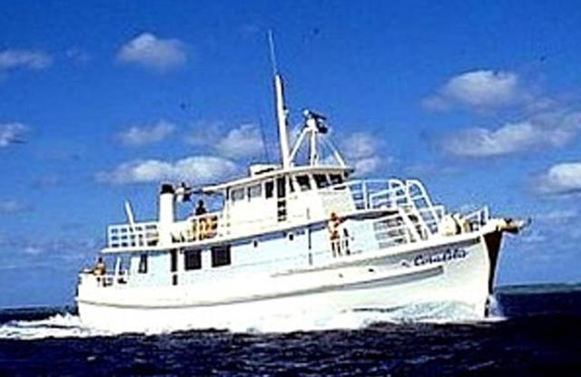
Nat Map’s first bathymetric survey charter vessel TSMV Coralita.
(It is seen here on a later private charter at Osprey Reef.)
Len Turner decided to commence bathymetric survey operations by letting tenders for private sector contractors that were to undertake all the sea-borne survey work in the presence of a Nat Map observer. To help develop tender specifications, Nat Map engaged the services of a former Royal Australian Navy Hydrographer, Commander Edward Ronald Ron Whitmore RAN, who had retired as Hydrographer in March 1970. The initial contract covered an offshore area from Sandy Cape on Fraser Island south to Point Danger on the Queensland-New South Wales border. The contact was let to Australian Maritime Services; a new start-up firm that had submitted a sound proposal. The company’s front man was another experienced former Royal Australian Navy officer Tony Cooper. (Commodore Anthony Hawtrey Cooper RAN joined the Royal Australian Navy at age 13 years and served for some 38 years including three terms as the Hydrographer RAN. Commodore Cooper formally retired from the Navy in May 1972. He was the surveyor in charge of Nat Map’s first bathymetric survey that initially used the TSMV Coralita and later used the MV Murphy Star.)
The TSMV Coralita was a wooden hull passenger boat of 69 feet 6 inches in length (21 metres) and was certified for world-wide charter work. As mentioned, she was the vessel used for the start of the first bathymetric survey contract. Her twin screws were powered by a pair of Caterpillar diesel engines and she had a sea-going endurance of some 14 days. (The Coralita was built in 1969 by Norman R Wright and Sons at their Bulimba ship yard on the south bank of the Brisbane River adjacent to the Apollo Road ferry terminal. The company continues today and has now been in operation for over 105 years.) Len Turner was the initial Nat Map observer on the Coralita’s first bathymetric survey and joined the ship at Mooloolaba after the summer wet season in early 1972.
Peter O’Donnell recalled being the Nat Map observer on the second bathymetric survey off the coast of New South Wales during the second half of 1972. The survey was undertaken by the contractor firm Australian Hydrographic Services using the 112 foot (34 metres) hydrographic survey vessel Ataluma. The contract started in Coff’s Harbour in June 1972 where Len Turner spent a few days discussing Nat Map’s requirements with the contractor’s surveyor-in-charge Hugh Vaughan (formerly Commander Hugh Vaughan RN (retired) who had a distinguished career with the Royal Navy’s Hydrographic Office). A month or so later, Len again visited the Ataluma when she put into Port Kembla. Here Len discussed with Hugh Vaughan procedures to be followed to overcome operational difficulties with one of the depth sounders.
Later during the survey Peter O’Donnell had some concerns with the contractor’s procedures. Accordingly, he contacted Len Turner in Canberra who soon afterwards met Peter at Ulladulla when the HV Ataluma put into port in September 1972. Len straight away sorted out the problems with the contractor and he and Peter stopped in Ulladulla for the night. Afterwards Peter resumed survey work on the Ataluma. (The MV Ataluma was a British designed Fairmile B motor launch. This class of vessel was initially built in 1940 as a submarine chaser. During World War II, such Fairmiles were built in Britain, Canada, South Africa and New Zealand. On the night of 24 December 1974, the HV Ataluma was wrecked at Dudley Point in Darwin Harbour during Cyclone Tracy.)
As well as the TSMV Coralita and the HV Ataluma, other vessels used by contractors on Nat Map bathymetric surveys were the MV Murphy Star, the MV Manly Cove and the MV Bluff Creek.
From 1972-1973 onwards Nat Map used Department of Transport Navaids vessels for most of the further offshore work; principally the Melbourne-based MV Cape Pillar but also the Perth-based MV Cape Don; both of 2,100 tons. The availability of these and other Navaids vessels was a result of the increased use of automated navigation lights that in turn reduced the DoT’s operational use of such vessels. Nat Map used the two Cape ships with Nat Map’s own survey staff and equipment.
Nat Map also chartered two other Navaids vessels from the Department of Transport. These vessels were used for closer inshore work with Nat Map survey staff and equipment. The first of these vessels was the MV Lumen of 264 gross tons with a length of 28 metres that was used in the Torres Strait around 1976-1977. The second vessel was the 11 metre motor launch Candela that was used in Spencer Gulf around 1977-1978. Nat Map also provided its own survey staff and equipment for survey work using the DT Burrowaree off Tasmania’s east coast. The TSMV Febrina was used by Nat Map during the 1980s for inshore work in Great Barrier Reef waters.
On the Cape Pillar, a Doppler satellite system and Doppler sonar navigation system were used to position the vessel. The former system interrogated satellites in the world-wide Navy Navigation Satellite System to periodically fix the position of the ship. The Doppler sonar system was linked to a gyro compass to obtain course and speed data that was used to calculate the ship’s position between satellite fixes. Water depth measurement was done with Atlas Deso 10 echo sounders. An expendable bathythermograph was occasionally deployed to determine the temperature profile of the water that was then used to set the echo sounders.
On smaller vessels such as the Febrina which used Nat Map survey staff and equipment, positioning was achieved through a Decca Hifix 6 radio positioning system (that worked on signal phase comparisons). There was also a back-up positioning system, namely a Motorola Mini-Ranger (that was a radar-based time phase system).
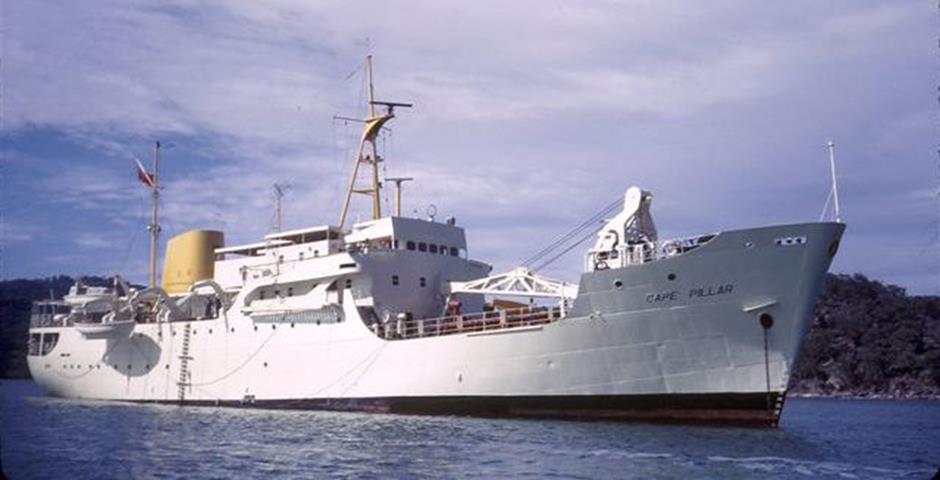
MV Cape Pillar that was used for much of the bathymetric survey work.
Visit to North America and England 1974
By 1974, bathymetric data acquisition processes were progressing satisfactorily and Len turned his attention to the cartographic aspects of the program. Bathymetric maps were a new concept for Nat Map’s cartographers and (as mentioned above) differed considerably from traditional hydrographic charts. Thus the bathymetric program had started almost from scratch to design a suitable format for the maps it needed to produce. Accordingly, Len took the opportunity to visit North America and the United Kingdom to keep abreast of the overseas trends in bathymetric mapping and equipment and cartographic developments.
During 20-25 May 1974, Len attended an international symposium on Problems Related to the Redefinition of North American Geodetic Networks. It was held at the University of New Brunswick at Fredericton, Canada. Len later visited the eastern division of the Canadian Hydrographic Office located at Dartmouth on the opposite side of Halifax Harbour from Halifax in Nova Scotia. During 3-5 June 1974, Len attended another international symposium on Applications of Marine Geodesy. It was held at the Battelle Memorial Institute in Columbus, Ohio in the United States.
Len later visited the control room of the National Aeronautics and Space Administration at Houston, Texas. He also visited the positioning and nautical equipment manufacturers (Teledyne) Hastings Raydist when he was in Newport News, Virginia. Len also spent a short time in England where he visited a positioning equipment manufacturer in Guildford, Surrey.
Other Management Activities
One of the additional management activities Len Turner undertook in the mid-1970s was a structural review of Nat Map’s Melbourne office. Other members of the review team included departmental central office senior administrator Laurie Worsnop (1946-2011) and representatives of the relevant staff associations. Background to the review was the winding-down of primary survey control acquisition activities within the Melbourne office and a move to greater emphasis on map compilation and map completion activities as well as the need to find resource savings.
The structure recommended from Len’s review was implemented after the Melbourne office was relocated to Dandenong in April 1977. The new structure achieved the needed reduction in overall positions but with few actual staff loses. The new structure included some innovative arrangements such as the management of work teams being undertaken jointly by professional and para professional officers.
Executive Development Scheme 1977-78
Nat Map’s third and longest serving Director Bruce Lambert retired in early 1977 and in a kindly parting gesture he nominated Len for participation in the Public Service Board’s proposed executive development initiative. Thus in 1977, Len took that opportunity to attend the commonwealth public service’s initial Executive Development Scheme course while on 15 months leave of absence from National Mapping. The course was aimed at developing executives who had shown the potential to reach a higher level in their organisations. That level was then known as the Second Division of the public service; later called the Senior Executive Service. The course was held on a residential basis for 13 weeks at the Ingleside Convention Centre near Mona Vale on Sydney’s northern beaches. There was only one break for a long week end during this period when attendees were allowed home.
After successfully completing the initial course work, Len spent the next 12 months undertaking three short term placements with various organisations to get hands-on executive level experience in different organisational roles. Len’s first placement was with the then Bureau of Statistics. Here Len took up the role of the organisation’s personnel officer as the incumbent was on furlough. Len handled the role successfully.
Len’s next executive development placement was with the Victorian State public service where he worked with the State Public Works and Education Departments to improve the process for allocating furniture to State schools. To this end Len negotiated with these two departments and the State Finance department and Public Service Board to develop a new school furniture allocation process. The system Len devised involved schools being given a financial allocation against which they could bid for their furniture needs. While this system yielded some success when Len was driving it, he had some reservations as to its use being continued after he had moved on.
Len final executive development placement was with National Mapping’s home department (then called the Department of National Resources; from 1979 the Department of National Development and Energy; and from 1983 the Department of Resources and Energy). During the early part of this placement Len prepared a thesis on the pros and cons of a resource rent tax. Later Len spent time in the department’s ministerial liaison unit. Here Len worked on the establishment of a National Energy Research, Development and Demonstration Council.
Central Office Policy Work 1978-1988
In 1978, with his 15 months on the Executive Development Scheme coming to a close, Len was at a cross roads in his career. Instead of returning to Nat Map as an Assistant Director he decided to continue on his development path. Accordingly, he took up a position as a section head in the National Energy Research, Development and Demonstration Council Secretariat. This career choice involved a slight reduction in salary from Assistant Director (Surveyor Class 4) to a Class 11 in the clerical/administrative pay grades. Class 11 was then the highest grade possible for a non-Second Division officer in the clerical/administrative grades.
Len’s final substantive position was in the Test Site Management Branch of the Department of Resources and Energy’s Uranium and Nuclear Division. The Branch advised the commonwealth government on the long term effects of British nuclear tests conducted in Australia between of the 1952 and 1963.
These tests were held at sites on the Monte Bello Islands about 120 kilometres north-west of Dampier on the Pilbara coast in Western Australia and at Emu Field and Maralinga; both in outback South Australia. (Emu is located about 230 kilometres north-west of Coober Pedy and Maralinga is further to the south-west about 35 kilometres north of Watson on the Trans Australia rail line and about 240 kilometres east of the Western Australia border).
A driving force behind the establishment of the Test Site Management Branch was the government’s concern with Aboriginal peoples’ claims to their lands; some of which were still prohibited areas under the Defence Act. Another driver behind the Branch was public concerns about the nuclear tests and possible harmful effects on the Australian servicemen who assisted the British and provided security and logistical support. The latter concerns resulted in the government establishing in 1984 a Royal Commission into the British Nuclear Tests in Australia under Chief Justice James McClelland of the New South Wales Land and Environment Court.
Len’s Test Site Management Branch provided the secretariat for the Royal Commission including being heavily involved in searching the archives in both Australia and Great Britain for factual material on the tests. As part of his role in the Branch, Len visited the Australian test sites.
The Australian government was keen to involve the British government in further investigations and was conscious of the expensive clean-up efforts by the United States government at its own nuclear test sites. Thus a Technical Assessment Group was formed and Len was given the task of running the group.
The TAG included scientific representatives of the National Radiation Laboratories; the CSIRO Nuclear Safety Division (which provided the Chair); the United States’ Radiation Protection Laboratory; the United Kingdom’s Atomic Energy Commission; and the UK Radiation Protection Board. Len’s work here involved organising and attending meetings of the TAG in Canberra, the United States (including a Nevada test site inspection) and the United Kingdom where Len edited the Group’s report. The report was subsequently submitted to the Australian government for consideration.
In his various early post-Nat Map appointments Len was seeking to gain a solid grounding in policy development work. However, he was later to remark to some of his Nat Map colleagues that his experiences during some 10 years in this area of government administration were not always rewarding and at times were rather frustrating. While he later gained some temporary appointments as an Assistant Secretary (Second Division) within the department these were invariably on an acting only basis. Len sometimes felt that his lack of formal academic qualifications held him back despite his considerable track record in successfully implementing major national mapping projects. Eventually he began to consider other pursuits.
Retirement
By February 1987, Len was discussing the mechanics of early retirement with at least one Nat Map colleague. Len Turner initially retired at age 55 years from the then Department of Primary Industries and Energy central office in the Jolimont Centre on Northbourne Avenue in Canberra’s city centre in mid 1987. However, Len’s wife Kath was still working as the School Secretary at Hawker College and preferred not to retire until after February 1988. Thus Len offered to return to the Test Site Management Branch as a temporary part time consultant to assist his old section in computerising records for archived test site related files. This work had not been completed prior to the Royal Commission report being tabled in Parliament in November 1985.
Len and Kath eventually retired in June 1988 and moved to Queensland about a month or so later. Here they firstly settled at Springwood on Brisbane’s south side. Later Len and Kath moved to the Gold Coast where they lived at Gaven and later at Robina. In 1994, Len and Kath decided to move to the far south coast of New South Wales where they settled at Merimbula.
Len Turner (right) with unknown Natmapper in the field (courtesy Terry Douglas).
Vale
Sadly, Len Turner died at age 70 years in the early hours of 9 June 2002 at the Bega District Hospital. Len had been diagnosed with leukaemia about three years prior to his death. He was survived by his sister Catherine, his half-brother Ivan, his widow Kath and by their three children Tim, Dianne and Michelle. Len’s funeral service was held in the week following his death at Canberra’s Norwood Park Crematorium in Sandford Street, Mitchell; afterwards Len’s remains were cremated and his ashes were later interred in the John Flynn Gardens at Norwood Park. Although it is now over 12 years since Len Turner died he is sadly missed by his family and by the many Nat Mappers who had the privilege of working with him.
Addendum
Sadly, Len's widow Kathleen Vallantyne (Kath) Turner (nee Grewar) passed away peacefully at Canberra Hospital (Garran) on 6 March 2015 at age 87 years. Kath was survived by her children Timothy, Dianne and Michelle. Nat Mappers who knew Kath from Len's Nat Map days were saddened to learn of her passing and extended their sympathies to her children.
References
Anonymous (undated), Europa Petroleum Products in the History section of the Todd Energy web site accessed on 20 July 2014 at: http://www.toddenergy.co.nz/about/history/
Anonymous (undated), Aerodist: An Airborne Tellurometer System, an 8-page publicity brochure produced by Tellurometer Pty Ltd a division of the Instrument Manufacturing Corporation Limited, Plumstead, Cape Province, South Africa, accessed on 29 July 2014 at: http://www.xnatmap.org/adnm/ops/prog/fbk/index.html
Anonymous (undated), Fairmile B motor launch entry on Wikipedia website, accessed on 7 August 2014, at: http://en.wikipedia.org/wiki/Fairmile_B_motor_launch
Australian Government (2014), Earl Bruester McDonald James entry on the It’s an Honour database, accessed on 19 July 2014 at: http://www.itsanhonour.gov.au/Honours/honour_roll/search.cfm?aus_award_id=887620&search_type=simple&showInd=true
Burke, Kevin (2014), Personal communications June-July 2014
Douglas, Terry Llewellyn (2014), Personal communications June 2014
Ely, John Herbert (2014), Personal communications June 2014
Flapan, Mori (undated), TSMV Coralita entry in Wright Boats section of the Register of Australian and New Zealand Ships and Boats, accessed on 27 July 2014 at: http://www.boatregister.net/WrightList.htm
Kirkby, Sydney Lorrimar (2014), Personal communications July-August 2014
Langhorne, Peter Handley (2014), Personal communications August 2014
Leahy, Francis Joseph (2014), Personal communications July-August 2014
Lines JD (1965), Aerodist in Australia, a paper presented to the 8th Survey Congress, Canberra, April 1965, later published in The Australian Surveyor, Volume 21, Number 2, June 1966, pp 733-755, The Institution of Surveyors, Australia, ISSN 0005-0326 and accessed on 13 July 2014 from XNatmap website at: http://www.xnatmap.org/adnm/ops/prog/aerodist6364.htm
Lines, John Dunstan (1992), Australia on Paper: The Story of Australian Mapping, Fortune Publications, Box Hill, Victoria, ISBN 0646097695
Manning, John (2014), Personal communications July-August 2014
McMaster, CG (1980), National Mapping Aerodist Program, Natmap, Department of National Development and Energy, Technical Report 27, Canberra, ISBN 0 642 51459 3, accessed in July-August 2014 at: http://www.xnatmap.org/adnm/ops/prog/aerodtr.htm
McMaster, Carl (2014), Personal communications June-August 2014
O’Donnell, Peter (2014), Personal communication July-August 2014
Turner, Leonard George; Kirkby, Sydney Lorrimar; Veenstra, Con; Ely, John Herbert and others (1962-1968), Aerodist Log Book, an unpublished (incomplete) manuscript of Aerodist equipment testing and operations from January 1962 to August 1968, prepared by officers of the Division of National Mapping, Melbourne.
Turner, Leonard George (1967), Aerodist operations in Australia, in Technical Papers presented to the Fifth United Nations Regional Cartographic Conference for Asia and the Far East, Volume 2, reference E/CONF.52/L.44, held in Canberra during 8-22 March 1967 and accessed in July 2014 from XNatmap website at: http://www.xnatmap.org/adnm/ops/prog/aaerod/index.html
Turner, Leonard George (1974), Mapping Australia’s continental shelf, in Technical Papers presented to the Seventeenth Australian Survey Congress pp128-135, held in Melbourne during 23 February-1 March 1974.
Turner, Leonard George and Mitchell Harvey (1977), Satellite imagery and its application to offshore mapping in Australia, Paper 8 in Technical Papers presented to the Twentieth Australian Survey Congress, held in Darwin in May 1977.
Turner, Leonard George (undated), Quo Vadis: That’s the Story of my Life, an unpublished memoir prepared by Len Turner for his children and kindly provided for research purposes by Len’s son Dr Timothy Leonard Turner in July 2014.
Turner, Timothy Leonard (2014), Personal communications July-August 2014
Vassil, Romulus Anthony (2014), Personal communications June-July 2014
Veenstra, Anne (2014), Personal communications June 2014
Veenstra, Con (2014), Personal communications June-July 2014
Wise, Paul Joseph (2014), Personal communications June-July 2014
Wise, Paul Joseph (2014), Bathymetric Mapping: Nat Map’s Unfinished Program, a forthcoming article that is anticipated to be posted on the XNatmap website at a future time.