DIVISION OF NATIONAL MAPPING
REPORT OF AURORAL BASE LINE SURVEY, MACQUARIE ISLAND – 1958
by
J.D. LINES – Senior Topographic Surveyor
INTRODUCTION
Following the siting of auroral photo theodolites at each end of the Island, some 20 miles apart, members of successive A.N.A.R Expeditions (Grant, Wilkinson and Cole), endeavoured to connect these instruments by triangulation survey to obtain the interconnecting length and azimuth. This was a task undertaken by the auroral physicists in addition to their normal duties.
The relative positions of the instruments were required to an accuracy of 1:5,000 so that accurate determination of position in space of the aurora could be obtained from simultaneous photography of this phenomenon from the cameras at each end of the island.
The triangulation was, of necessity, carried along the plateau of the island, and completed during the term of the 1956 expedition. This was an achievement in itself owing to almost completely prevalent conditions of low cloud, fog, rain and the strong westerly winds. Transport of equipment and other necessities is entirely by manpower as movement of vehicles is restricted to the area immediately surrounding the main camp.
COMPUTATION OF TRIANGULATION
Computation of this work during 1957 induced some doubt of the accuracy of the work conducted under such trying conditions, and it was decided to make physical checks of some of the shorter lines during the relief of the 1957 expedition.
TOPOGRAPHY
Macquarie Island is a long narrow plateau rising steeply from the sea and surrounded generally by a narrow coastal terrace. The rock is of igneous origin and the plateau, generally at elevations between 700 and 1000 foot with peaks to 1400 foot, is undulating, dotted with lakes, and offers very spongy and wet walking conditions over moss and occasional patches of scree.
The only substantial vegetation is coarse tussock grass extending from sea level to varying heights along the sides of the plateau particularly on the more protected eastern side.
METEOROLOGY
The following extracts are taken from A.N.A.R.E. Interim Report No.14 – “Macquarie Island".
General
The island is subject to persistent cloud cover and there is little bright sunshine. Rain, drizzle, snow and small hail are frequent but generally light, and give an annual precipitation of 40 inches occurring on about 330 days of the year. Fogs and misty conditions occur frequently at all seasons. Completely cloudless skies are uncommon.
Temperature
From tables in the report the mean daily maximum and minimum temperatures (°F) for the year are 42.9 and 36.8 and for the month of December, 45.7 and 39.9.
Humidity
The air is rarely far from saturation. Approximately half the observations show a relative humidity of 90% or greater, while approximately one tenth show a relative humidity of less than 70%. The mean relative humidity is 88%.
Wind
Calm conditions prevail for 35 of the time and the median wind is very nearly 20 knots.
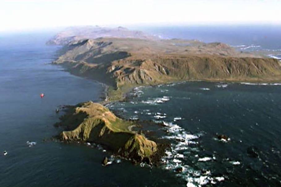
Macquarie Island looking south with ANARE Base in low area at centre of photo.
CHECK AND RECONNAISSANCE 1957
Three lines were checked during the relief period and confirmed the view that the base length was of the order of accuracy of 1:100 at best.
These checks involved a return journey on foot between the main camp at Buckles bay and the southern camp at Hurd Point, and yielded not only the information sought but provided a first hand experience of the difficulties, particularly the low cloud base at frequently 600 feet, that would face any survey party attempting to undertake triangulation in a reasonable time.
The alternatives were reduced to leaving a wintering party for a year to reobserve 20 miles of triangulation with no real prospect of a successful conclusion, or to attempt a coastal traverse on the lee side of the island employing the recently proved Tellurometer equipment.
Coastal traversing had the additional advantages of being below the cloud base and fairly accessible by foot.
It was felt the latter proposal, with good logistic support, could be completed within the time available during the 1957-58 relief.
The long hours of daylight during the limited time available for the many and varied domestic and scientific tasks to be undertaken during the relief, were to prove the margin between success and failure.
PLAN OF OPERATIONS 1958
After joint consideration or the alternatives between Antarctic Division and Division of National Mapping, it was agreed that the coastal traverse should be attempted.
To ensure the best prospect of success, the survey party consisted of six (6) men (see Appendix ‘A’) and it was to be supported by a helicopter, a Hiller 12C, chartered by Antarctic Division and carried on the ship, M.V. "Thala Dan".
The ship departed Melbourne on 26th November and survey operations began on 1st December and ceased on 12th December.
SURVEY EQUIPMENT
The major items consisted of two (2) sets of Tellurometer equipment, three (3) Wild T2 theodolites and three (3) dry-cell operated V.H.F. transceivers. The spare set of Tellurometer equipment was loaned by the Royal Australian Navy.
OPERATIONS
Reconnaissance and marking were undertaken with the helicopter, and in all seven stations were established. The survey party broke into 2 or 3 groups as required and were transported on occasions by helicopter, ship, ship's boat, DUKW and dinghy.
The sudden closing of visibility, the choppy sea and strong winds frequently necessitated walking and back-packing the equipment.
Systematic organisation frequently broke down when, for instance, the whole party was on the ship and after one party or portion of a party was landed by helicopter, the weather would suddenly close in and the manning of the other and of the line was not completed. Owing to the limited load capacity of the helicopter, only emergency rations and life jackets could be carried on a single trip and the landed party, if still abandoned at nightfall, were faced with the necessity of covering equipment and walking some distance to shelter.
However, with the helpful co-operation of the ship's officers and the Expedition leader, hasty organisation made good use of the suitable weather for the various forms of transport.
TELLUROMETER OPERATION
Detail of equipment
Model MRA-1, No.74 (Master & Remote) were used entirely on the operation. This equipment was not modified with the thermostatically-controlled crystal ovens. Power supply was by both lead-acid and nickel-cadmium accumulators.
Psychrometric readings were obtained with dry-cell operated Bendix aspirated psychrometers and barometric pressure with batteries of three aircraft altimeters.
Atmospheric Temperatures
During equipment operation, these varied between (°F) 38.8 and 45.8. Readings were generally in the vicinity of 42.
Crystal Temperatures
Under the conditions, 15 minutes was the normal time for the crystals to reach operating temperature.
On two occasions it was not possible to reach a satisfactory temperature, once when the accumulator charge was suspect, and once when the wind was strong and no shelter available.
Limiting Conditions for Measurement
Lines were measured in light rain and fog (visibility 300 yards) and broke down only once during a short snowfall. It was noticed that even very light snow attenuated the signal very badly.
Ground Swings
Measurement of NM/X/3 (Brothers) to NM/X/2 (Nuggets) necessitated re-siting the Master at X/3 twice before a satisfactory measurement was obtained across the intervening water.
The party was landed on top of Brothers by helicopter at an altitude of approximately 600 feet. This siting and another about 400 feet above the sea were fruitless. Finally, a site at an elevation of 250 feet to Nuggets at 140 feet reduced the swings to reasonable proportions.
Reliability of Equipment
Although every reasonable care was taken with the equipment, it was not always possible to shield it from shocks during surf landings, helicopter transport and back-packing over rocks.
Under these and the extremely humid conditions, the equipment functioned very well. Care was taken to prevent it being warmed in heated shelter to minimise condensation as far as possible.
ANGULAR WORK
Great trouble was experienced with instrument platform. As we had selected to traverse along the lower points, several of the platforms were in tussock grass. The roots of this grass provided a very deep sponge affect with the consequence that instrumental level was very difficult to maintain.
With the hurried nature of this operation and load limits of the helicopter it was not always possible to improve the platforms. At NM/X/3, situated on a steep slope, planks were nailed to long pegs driven in around the tripod and even so the necessary movement of the observer on this platform caused variations in the plate bubble. The angle at X/3 was reluctantly accepted, as further improvements to the platform were not practicable at the time.
AZIMUTH CONTROL AND ORDER OF ACCURACY
The initial azimuth and NM/X/1 – NM/X/2 was derived from extra-meridian observations of the sun. Further some shots were not possible along the traverse.
A check azimuth at the southern end, NM/X/7 – NM/X/6, was not possible during the course of the survey and was subsequently observed by the auroral physicist using extra-meridian star observations. Computation showed these observations to be not normally acceptable. The mean value differed from the carried forward azimuth by 30 seconds of arc. In view of the difficulties experienced in angular measurement at NM/X/3 it is considered the survey is of THIRD ORDER standard.
ORIGIN OF SURVEY
The survey was based on a connection from and NM/X/1 to the Seismological Observatory where Mr. Surveyor Dovers, A.N.A.R.E., observed an astro-fix in 1950. The value of this observation is stated to be :
Lat : 54° 29’ 54.8” S
Long : 158° 57’ 21.9” E
Further observations for position were not possible due to cloud cover.
NAMING OF STATIONS
Names used were taken from a map prepared by Mr. Blako, geologist and surveyor to the Australian Antarctic Expedition 1911-14.
HELICOPTER OPERATION
The Hiller 12C helicopter had a load capacity of approximately 450 lbs. for short hauls under steady conditions. Owing to the almost continual marginal conditions for operations, particularly with the down-draughts generated along the steep slides of the island, passenger loading was usually reduced to one together with some equipment.
The sudden closing-in of visibility was a hazard that continually interrupted and disorganised the work.
However, during the last day available for survey operations, a clear break occurred from 0500 hrs. to 1130 hrs., and no less than five stations were occupied for one Tellurometer measurement, and some outstanding angle measurements previously unobtainable owing to bad visibility. Without the helicopter there is little doubt that the survey would not have been completed.
Total time use during the period was 25¾ hours of which 21¼ was used specifically for the survey.
It might be mentioned that the helicopter work in these conditions was not without its anxious moments.
STATION SUMMARIES
A Trigonometrical Station Summary has been prepared for each station.
ILLUSTRATIVE PHOTOGRAPHS (not available)
Four photographs showing the approximate locations of NM/X/1, 2,3,6 & 7.
The other three photographs illustrate the Tellurometer set up at NM/X/2 and directed towards NM/X/3.
The helicopter on its helipad on the ship which was the central point of operations.
A view of the main camp at Buckles Bay, December 1957.
APPENDIX A
Personnel Division of National Mapping
JD Lines Senior Surveyor
MA Nicholas Surveyor Grade 3
J Slama Field Assistance (Svy)
Royal Australian Navy
Lt. Cmdr. IM Burnside Navigator
Queens Scouts (attached to expedition)
D Hindle
J Harris
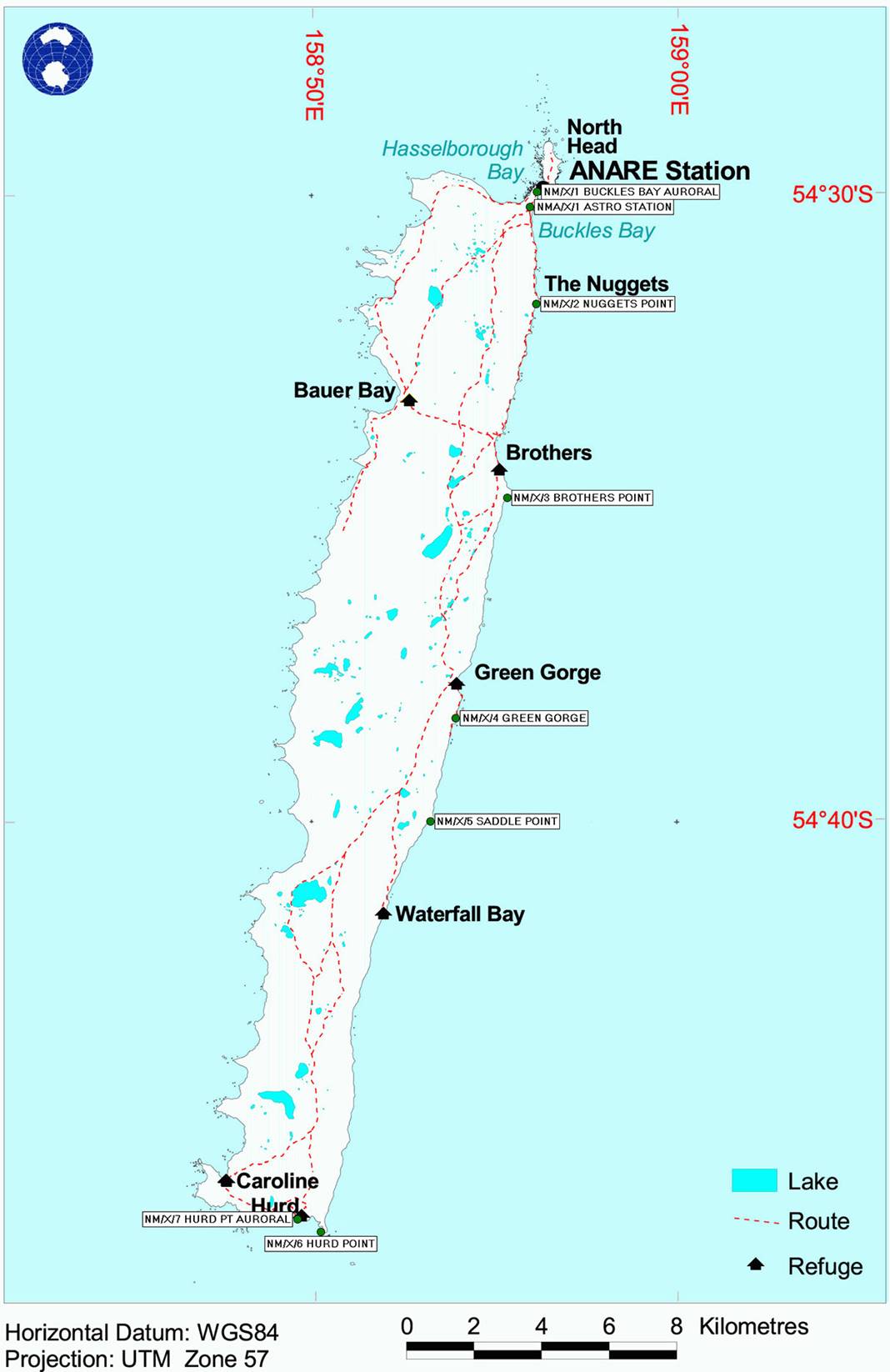
Map of Macquarie Island showing the 1950 astro-fix site (NMA/X/1) at Buckles Bay and the sites of the auroral photo theodolites at each end of the Island (NM/X/1 and 7 respectively). Also indicated are the locations of the five intermediate traverse stations (NM/X/2 to 6) used to connect the two photo-points in 1958.