THE
DIVISION OF NATIONAL MAPPING’S
GEODETIC
SURVEY OF PAPUA NEW GUINEA –
A
PERSONAL PERSPECTIVE
by
John Allen and David Cook, October 2009
Introduction
In
April 1974 the Directorate of Overseas Surveys, Great Britain, wrote in their
Information Services Newsletter, “The Australian geodetic network, a great deal
of it completed in ten years, must always be historically one of the survey
wonders of the world”.
Although
this statement of recognition was primarily directed to the vast geodetic
network within the Australian continent, geodetic control was also extended
into Papua New Guinea (PNG) where surveying teams faced vastly different
conditions and challenges to those experienced within Australia.
This
geodetic survey of Papua New Guinea was a joint operation by the Royal
Australian Survey Corps and the Division of National Mapping. The Army's
responsibility was to establish survey control around the coastal perimeter,
and the Division’s to establish geodetic control throughout the mountain
ranges.
For
the first time in their field operations, helicopters were used by the Division
to position survey parties on the selected mountain peaks that ranged in altitude
to nearly 15,000 feet. In a well planned and coordinated operation, albeit one
of high risk, the geodetic survey was completed in four years.
Shortly
after the conclusion of the work, a report entitled “The High
Level Geodetic Survey of New Guinea (Technical Report No. 8, March
1969)” was written by the Division’s Supervising Surveyor, H.A. (Bill) Johnson,
but had a strictly technical focus.
As
this particular survey was so unique, the Authors, as members of the PNG
geodetic survey party, have compiled this paper to ensure that the personal and
other aspects of this important work is not overlooked or forgotten. In
addition, the Authors pay tribute to all our National Mapping colleagues, as
well as those from the Royal Australian Survey Corps and the PNG Department of
Lands Surveys and Mines who assisted on this survey because it truly was a team
effort.
Imperial
units of feet (ft), pounds and ounces (lbs, ozs) are retained as these were the
measurements of the time.
Background
to the High Altitude Geodetic Survey of PNG
For
many years Australia had a special relationship with Papua New Guinea (PNG or
sometimes TPNG for Territory of Papua and New Guinea).
In
1904 the Commonwealth of Australia began administering British New Guinea,
which was the southern half of the partitioned island, and in 1920 Australia
assumed a mandate from the League of Nations (predecessor to the United
Nations) to govern the northern half, formerly known as the German Territory of
New Guinea. It was administered under this mandate until the Japanese invasion
in December 1941 brought about the suspension of Australian civil
administration.
After
World War II, the two territories were combined into the Territory of Papua and
New Guinea, which name was simplified later to Papua New Guinea, and Australia
continued its administration overseen by the United Nations.
The
war years had revealed the inadequacy of reliable mapping in PNG. During those
years there was little opportunity to rectify this, but as early as 1942 and
1943, H.A. Johnson, then an officer in the Australian Army, was able to
reconnoitre parts of the country. Whenever possible, courtesy of the United
States Air Force, he obtained flights over the mountain ranges with a view to
identifying possible mountain peaks to form a geodetic framework. He also
gained first-hand knowledge of the physical difficulties on the ground that
would be encountered when beaconing those peaks. However, with the cessation of
military survey activities in 1945, the commencement of a geodetic survey over
PNG lapsed into abeyance.
In
July 1958, at the request of the Administrator of PNG, for advice on how best
to satisfy their serious mapping needs, the Director of National Mapping, B.P.
Lambert flew to Port Moresby. He attended conferences of the Technical
Committee on Photogrammetric Mapping and made a wide aerial reconnaissance of
the area to form an appreciation of the requirements.
A
fundamental conclusion was reached being that a proper geodetic framework was
required over PNG as soon as possible, and that the framework should be
connected to the Australian network. Following that conclusion, two main traverses
were planned – one around the coastline (low) and another along the central
ranges using the major peaks (high), with selected connections between these
high and low surveys. Annex A contains a general map of PNG circa 1969 while
Annex B shows the High and Low Geodetic Net.
Original
Mapping
In
1961, at the commencement of the Division of National Mapping’s (Natmap) work
in PNG, most maps of the vast interior of the country were sketchy. Mountain
peaks had been identified but heights and positions were approximate or
incorrect. Maps of the ranges west from Mt Hagen to the West Irian border were
a collation of sketches of indeterminable scale that depicted mountains of
somewhat random shape and height.
As
an example of this unreliability, Mt Suckling in the south-east was originally
fixed by Captain Owen-Stanley early in the 19th century by compass bearings
from his boat as he sailed around the eastern end of the island. However a patrol officer’s report in the 1950s related that,
while working along the north coast, he had climbed the mountain on a Saturday
morning in cloudy weather and that it was 15 miles closer to the coast and
lower than the map showed. This notification was classified as a reliable
report and was sufficient to cause Mt Suckling's position on the map to be
changed. When beaconing was carried out by National Mapping’s Technical
Assistant, Guy Rosenberg in July 1962, his astronomical (astro) fix confirmed
the original position determined by Captain Owen-Stanley as being correct, and
this was later verified by an astro-fix at Mt Simpson and an azimuth
observation to Mt Suckling ‘s beacon. (Guy Rosenberg's ascent of Mt Suckling
was a little more arduous than the Saturday morning climb that gave credence to
the mapping error. It took Guy eight days to climb from Safia, plus two days to
build rafts and cross the Adau River and five days to return).
Other
mapping errors included Mt Albert Edward shown 2,000ft above its actual height,
but the most serious heighting error was that of Mt
Kenevi, just to the east of the Kokoda Gap in the Owen Stanley Range. This peak
had been wrongly identified and given a height of 8,487ft, when it was actually
11,315ft. Five wartime wrecks lie around its slopes at heights above that shown
on the original maps. One of these wrecks was that of an Avro Anson, LT294,
that crashed on 30th January 1944. Killed were Group Commander
Frederick Wight, the most senior RAAF officer to go missing in WW2, and Wing
Commander Keith Rundle. Shortly after the erroneous height of Mt Kenevi had
been discovered during Natmap's survey, the remains of the two airmen were
recovered and buried at Bomana War Cemetery on 5th March 1965.
It
may seem incredible that mapping errors such as these would not have been detected
prior to the arrival of the geodetic surveying team. For those most likely to
be affected by such errors, however, the commercial pilots of PNG did not
depend upon map accuracy as they were trained using visual flight procedures.
Trainee pilots had to fly five times along any route under the supervision of a
senior pilot before being cleared for solo commercial flights. Consequently
fixed-wing pilots all knew their way around the country without using maps and
the misplacement of Mt Suckling and the incorrect heighting of Mt Kenevi, (and
probably many other peaks), were not major problems. Light aircraft never flew
in cloud, and instrument flying was not used. Unfortunately
wartime pilots had flown under different rules and conditions, often with
tragic results.
The
commencement of surveys as a basis for accurate mapping in this region were
undertaken in the middle to late 1950s as Project Xylon and Project Cutlass.
The Royal Australian Survey Corps and the United States Army Corps of Engineers
combined in ship-shore triangulation surveys around the coastline of New
Britain and the islands of New Ireland (Coulthard-Clark, 2000). It should also
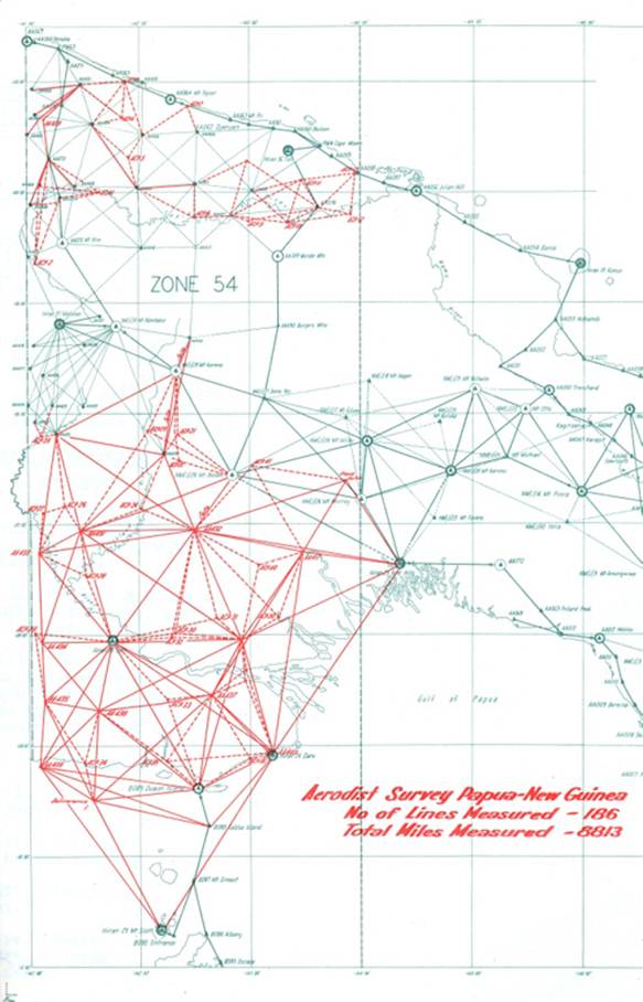
be noted that the Army undertook Aerodist (AERO DISTance measuring) operations
in the western region of PNG. Refer Annex C.
Later,
almost in parallel with Natmap’s work, during the period September 1962 to June
1964, another, more extensive survey operation was also underway, that of the
United States Southwest Pacific Survey. The aim of that survey was to establish the principal islands of
the Southwest Pacific area on a common geodetic datum using HIRAN (HIgh-precision
shoRAN).
To complete the story, Australia through National
Mapping was involved with the joint Indonesian and Australian Survey of the border
between the Territory of Papua New Guinea and West Irian in 1966/67.
The
Start of the Survey – Reconnaissance and Beaconing
H.A.
Johnson's personal experience in PNG in the 1950s and 60s gives an introduction
to what lay ahead for the beaconing parties. He wrote:-
“Papua
New Guinea lies between the latitude band of 2 to 11 degrees south and
generally receives more than 100 inches of rain annually. Such rainfall has created
dense tropical vegetation over most of the land, with great river swamps and
deltas. The country is geologically young and unbelievably rough – Mt. Wilhelm,
the highest peak stands at 14,800 feet. Many other mountains along the spinal
ranges are over 13,000 feet and are mostly interconnected with ridges and spurs
so steep and knife-edged it would seem that only a mantle of vegetation holds
them in place. At times of continuous torrential rain, rock falls and mud
slides are common. The few vehicular roads, many of them only suitable for
4WD's, often become blocked and bridges can be washed away. From the air, the
lower slopes that lead to the main ranges look deceptively smooth with
accessible grades, but on the ground the reality becomes a fascinating and
challenging new world of a silent, dripping, half-lit tangle of slippery roots,
spiny vines and bushes, with many buttressed trees festooned in moss. Progress
through this labyrinth is difficult and frustrating, as often long steep climbs
are negated by descents of similar magnitude before the next ascent begins.
Climbing out of the heat and humidity of the rain-forest, and leading up to
11,000 feet, the vegetation and terrain becomes less hostile, and pressing on
to higher elevations stunted beeches make way for alpine grass and then to bare
crags. These then were the majestic peaks, towering over myriad jungle clad
valleys and ridges, that became the goal of our reconnaissance and beaconing
parties.”
The
work of beaconing was undoubtedly the most physically demanding aspect of the
survey, but much satisfaction was derived in establishing each trigonometrical
(trig) point. Those involved knew that not only would the beacons mark the
origin and authenticity of all future geodetic and cadastral work, but would
also remain as permanent monuments for as long as nature and importantly man,
allowed.
In the following section
David Cook recalls some of his experiences
Appointed
by Natmap as PNG Resident Surveyor for the Geodetic Survey, I arrived in Port
Moresby in 1961 with my young family.
Widespread
cooperation and assistance would be instrumental to the success of the survey
necessitating good personal contacts with PNG Administration Departments,
commercial entities and others in the private sector, and also missionary
organisations. To help in this work a Frenchman, Guy Rosenberg, was also
transferred to Port Moresby from Australia.
In
developing a strategy to commence the work, the most important contacts were
people whose work had taken them into the mountainous regions where our work
was to be undertaken. As well as help from PNG District and Patrol Officers,
Catholic Priests in the Goilala area north of Port Moresby were able to give
assistance as some had climbed five of the mountains that were to be included
in the survey. All the advice was most helpful, particularly about a climbing
route for the almost precipitous, 10,750ft, Mt. Yule.
In
July 1959 beaconing for the high level survey
commenced on mountains near Port Moresby.
Selection
of Peaks for Beaconing
The
first step in beaconing the central mountain chain was to fly to the highest
peaks to check which were intervisible and select a succession of them to
establish the central traverse. Then, having made the selection, another aerial
reconnaissance of possible climbing routes was necessary. For example, the
south face of Mt Suckling was observed to be all steep landslips and falling
stones, dictating a route along a narrow ridge. Some peaks were going to be
very difficult, such as Giluwe with a huge, vertical sided rock on the summit,
and Mt Victory which turned out to be impossible, having a large high rock on
the summit that towered above surrounding thick forest with enormous trees.
However, the major deterrent for beaconing this peak was the fumerole at the
highest point exuding a steady flow of volcanic gas. (Mt Victory is only 50
miles from Mt Lamington which had erupted unexpectedly and violently in 1953
and caused some 3,000 deaths).
Hills
below 10,000ft were mostly heavily timbered and were required to be climbed on
foot and cleared, and some hills such as Wamtakin and Obree, needed a wooden
landing pad to be constructed to provide a safe landing for the future use of
helicopters. Some were too heavily timbered to be cleared, such as the highest
point on Goodenough Island, climbed by Guy Rosenberg, where trees were three
feet in diameter.
Once
the aerial reconnaissance of each peak had been made it was necessary to
contact the nearest District Office. All the Patrol Officers and District
Officers were consistently helpful with assistance regarding access routes,
recruitment of carriers, storage of cargo flown in before the climb, any
serious obstacles, and providing guidance on dealing with the local people as
some customs varied from one place to another.
Recruitment
of Carriers
A
climb, to the peak to be beaconed, generally started from the nearest Patrol
Post where, between 60 and 100 carriers were recruited, depending upon the
distance to be covered and their availability. Daily wages were set by the
local District Officer and clothing and personal equipment were provided to
each carrier. This consisted of a warm shirt, rain cape, blankets, eating gear,
and waterproof bag to carry them plus a mandatory food allowance including 1lb
of rice and 4oz of tinned meat per day. The maximum load per man was 40lbs and
the effective payload diminished by the day. Two crowbars for digging out rocks
for the cairn plus sleeping gear and a couple of day’s food
made up a 40lb load.
Most
of the walking was above the highest habitation or beyond where local food
might be purchased. Tents for 50 or more people, steel beacon poles, vanes, guy
rods and angle iron, cooking pots, theodolite, radio, axes, cement, spade and
so on dictated a maximum walking time of a week or so before resupply was
needed. Therefore one or two airdrops were planned for
all the longer climbs.
Airdrops
Most
of the airdrops were flown by STOL Air, Port Moresby, and Missionary Aviation
Fellowship at Tari with excellent accuracy and results. All mountain flying was
done in the early morning, taking off at first light, officially 20 minutes
before sunrise, and completed by about 10am before the daily build up of cloud
around the high peaks.
Flying
mostly in high wing Cessnas, C180 and C182, with the right
hand door and rear seats removed, the cargo was stacked behind the front
seats, secured in bundles of 30 to 40lbs. A pusher-out, alternately the
surveyor (when the technical assistant was on the ground leading the beaconing
party), or the technical assistant (when the surveyor was the recipient on the
ground), sat in the right hand front seat. On
approaching the mountain, the pusher-out climbed around the seat into the back, an operation fondly called ‘a white knuckle
exercise', and sat opposite the open doorway with feet against two or
three items of cargo. On the pilot’s command “Drop” he pushed the cargo out then
leaned out the doorway to report on the accuracy, in preparation for the next
run, As the pilots accumulated experience most drops landed within 50 metres of
the mark.
The
Cessnas dropped about 400 to 500lbs at 12,000ft. The use of oxygen above 10,000ft,
mandatory for pilots in Australia, was universally ignored in PNG except for
helicopter pilots landing above that altitude.
On
the ground, the dropping target, a 20ft cross of white cloth, was placed
wherever possible on the lee side of a ridge about 50 to 100 metres below the
top. Approaching drop time a smoky fire was lit for
the pilot to find the mark and to track into wind. The packages would then land
on the uphill slope square to the surface without rolling or bouncing, and,
with 50 people watching where everything landed, there were virtually no
losses. In an early experimental drop, a tightly sewn bag of 40 lbs of rice and
tins of meat inside a loose bag, was dropped from 1,000ft at Jackson’s Airport
and the inside bag remained intact. Also it was found
that dropping packages onto a level surface at a low height would cause much
damage and loss. Some pilots confused an imagined need for pinpoint accuracy
with the effect of packages landing at a high forward speed.
As
the air dropping technique improved other heavy unbreakable items were included
– crowbars, guy rods and steel pickets for the beacons, and cement for the
ground marks, wrapped tightly in a truck inner tube wired at both ends. Two
unwanted incidents occurred at Mt Suckling when two crowbars landing on a soft
patch and penetrated five feet into the ground, and a package of cement caught
momentarily on the aircraft's undercarriage, landing slightly long then
bouncing over the ridge and 1,000ft down the other side. It was a couple of
hours climb for a man to retrieve it.
One
airdrop had to be carried out by a local airline with no Natmap people
immediately available. The heavy packages of steel were deemed to be too
awkward to handle and were separated into smaller items and dropped all over
the open summit of Mt Bangeta with little pieces of rag attached to each one,
many of them never to be found. A replacement set of parts was able to be flown
in the next morning and dropped securely by the usual method. A useful
innovation was dropping a small package with a long streamer attached on the
first run as a sighting target. This was usually a welcome pound or two of
fresh meat.
Access
to the Peaks
There
were no high altitude helicopters in PNG until the two
for Natmap and Army Survey Corps arrived in May 1963 on an Army LST vessel.
There was virtually no road network in PNG and for all the beaconing work until
that time the only means of access to mountain peaks was to fly to the nearest
airstrip and then walk.
Whilst
close aerial examination had been made of the peaks with regard to the best
climbing routes, Mt Bosavi proved that what was seen from the air didn't
necessarily agree with what was on the ground. It had multiple sharp ridges
radiating downwards from the cone of the dormant volcano.
Having
selected from the air which ridge to climb the party reached the heavily
timbered rim of the crater after three days but it was found to be not quite
the highest point. The narrow crumbling lip of the crater could not be safely traversed
along the 1,000ft drop on the inside so it was down to the plains again, climb
the next radial ridge, clear the very large trees to find yet another small
peak to the south east very slightly higher. At this stage I developed chicken
pox, contracted during a home stay at Tari a couple of weeks before. Being
highly contagious and potentially serious, this prompted erection of the beacon
at that point, luckily with clear sight in all directions except a narrow
sector to the south east.
One
of the longest walks was to Mt Victoria, about 30 miles in a straight line from
the coast and required 56 hours of climbing. The route taken to each
mountain peak was recorded by compass bearings, walking times for loaded
carriers, and altimeter heights. The local practice when approaching a steeply
falling watercourse was to climb down from the ridge to the crossing point then
up the next ridge rather than following around the contour to a crossing at a
similar level. This latter method would have entailed longer distances along
very steep, slippery side slopes and it was soon recognised that the carriers
knew better. The net effect was that the total climb far exceeded the height of
the peak above the starting point. Mt Victoria was a prime example, requiring 23,000ft
of climbing from sea level to reach the 13,000ft peak.
In
addition to the well known difficulties of climbing
and safely descending steep, bare slopes of smooth clay in the rain, another
significant challenge was the crossing of mountain streams. Fed by daily rains
they ran swiftly and deep, crashing over slippery rocks and fallen trees. To
cross safely with a load required felling of one or more trees, sufficiently
long and close to the bank to lodge firmly on the opposite bank. Losing some
cargo would be one problem, losing a man would have been a major setback to the
program. A vital asset for the party leader was the well
chosen pattern of steel grips on his boot soles to contend with all
manner of unpredictable surfaces, particularly those of a wet, slippery tree
trunk. The carriers managed with amazing skill, usually in bare feet.
Even on near vertical climbs, requiring the use of hands, some carriers still
persevered with carrying two loads on a pole, one man at each end.
One
hair-raising incident on the walk to Mt Victoria occurred when crossing the
Wami River. The boys dropped a tree across, the branches lodged in the opposite
bank and everyone started to cross. I had just put one foot on the opposite
bank when the branches let go and I quickly pulled the other foot up. There was
a mad rush downstream to catch the blanket bags etc that were floating away but
of greater consternation was when one boy was found to be missing. A hasty
search located him amongst the branches of the tree, now stationary again,
still clutching the theodolite tripod but with his face just above water. There
was much clapping and cheering at his reincarnation, and then work started to
cut down a longer tree.
At
about 10,000ft, towards the tree line, an unexpected factor was bamboo grass.
From the air and on aerial photos it looked like smooth grass and easy walking
but in fact was a dense, deep forest of bamboo
runners only a few millimetres thick but 10 or more metres long, impossible to
walk through and very difficult to clear. Every stroke with a bush knife
required holding a bunch of runners with one hand and cutting with the other
resulting in very slow progress.
During
the climb to Mt Victoria an unusual situation arose. Due to the influence of
two different branches of missionary activity some of the 50 carriers
stipulated observation of their Sabbath rest day on Saturday, while others
required their Sabbath on Sunday. One of these days was used for an airdrop but
it lengthened the climb to ten days. After several days at 13,000ft in freezing
temperatures, violent storms and rain the Sabbath became less important and the
return journey took only five days. A mudmap explanation before the event of a
total eclipse at 9 o’clock one morning may also have influenced the carriers’
view of divine warnings and claims of Godly power they had received.
On
some stretches the carriers were able to hunt for game. On the climb to Mt Suckling
a track cutting party of four carriers and one policeman returned to camp one
day with 200lbs of fresh meat.
During
each climb it was mandatory for the beaconing party leader to provide medical
attention for the carriers and about an hour was set aside for this each day.
As the country became rougher, cuts and bruises were most common and the
afternoon line-up for attention became known as the ‘iodine parade’. A one gallon plastic bottle barely lasted for the length of
the trip. If illnesses occurred it usually required the man to be sent down
with a companion to help.
On
high mountains, over 12,000ft, the carriers usually camped at the tree line, at
about 11,000ft, where there was some shelter and firewood. Thirty or so would
go to the summit each day for a bonus payment above their normal wages and work
to erect the beacon and build the cairn.
At
the conclusion of the beaconing all the carriers would return to the Patrol
Post and hand in their personal gear and receive payment for their labour.
Usually 30 to 40 carriers would complete the whole journey, with the others
being used mainly in the initial stages.
In
newly contacted areas such as Kukukuku country a Patrol Officer was required to
accompany the party but the newly recruited people were invariably excellent
workers. People from remote areas were, generally speaking, not only
excellent workers but good companions. Nearer to the bigger towns
things were not always so easy as people from those localities had heightened
monetary expectations since seeing the introduction of western culture and
values.
Equipment
used by Beaconing Parties
Additional
to items previously mentioned, the following items were essential for the
beaconing parties:-
A510
radio, a small portable radio in two packs totalling about 10kg, on loan from
Army, worked very well. There was no regional network of repeater stations as
required by present day pocket sized telephones. It
required a dipole aerial 20 metres or so long to be strung up in trees and used
a 90 volt battery which did not hold its charge well
in high humidity. It did have the major advantage of having plug-in crystals
providing access to the telephone network and to civil aviation control tower
frequency for talking to aircraft during airdrops.
Light-weight
plywood boxes with a watertight lid. These were intended to be carried on a
wooden pack frame but often appeared after the first day tied two on a carrying
pole. These replaced the standard steel patrol box, one metre long,
traditionally used by Patrol Officers, which were difficult to handle on near
vertical climbs and descents.
One
small, one-man, metal box, lockable, for money, trade tobacco.
6
metre rolls of plastic for waterproofing carriers’ tents, which invariably
leaked copiously; also useful for collecting rainwater for cooking when not
near a river.
Large
cooking pots for rice for 60 plus people.
Other
standard equipment included:
Tilley
pressure lamp for night work which the boys, amazingly, could carry in its
wooden box for two weeks without breaking the mantle
Steel
frame stretcher, able to be used for sleeping on a steep slope with two boxes
under the downhill end, one box in the centre, and for sleeping in mud.
One
non-standard item which appeared on the walk to Mt Victoria was made from two
strips of truck inner tube and a piece of wire borrowed from the beaconing
gear. One of the carriers, on a break from his regular job of drydock diver in
Port Moresby, fashioned a spear gun, produced his diving goggles and sank into
the river where we were camped. In fifteen minutes he
came up with a welcome feed of three large fish.
Construction
of the Beacons
Beacons
were made from two 7ft long square steel pipes telescoped together to make a
14ft high target. The four vanes were 4 x 2ft, heavily galvanized and painted
black. Guys were four steel pickets bolted to the centre pole and sloping
outwards through the cairn to steel pickets driven into the ground and four
long steel rods jointed at about 5ft intervals from the outer edges of the
vanes down to turnbuckles fastened to steel pickets. The turnbuckles were
locked with steel rod passed through and u-bolted to the guys. The poles and vanes
had to be carried but everything else could possibly be airdropped. Each beacon
was assembled in Port Moresby before despatch to check for completeness, bolt
hole sizes, then dismantled, painted and packed.
Where
topography and rocks allowed, the cairns were 12ft diameter about 8ft high.
This required two to three days digging and carrying for 40 men, very hard work
at high altitude. The largest rocks were placed around the base and had to be
rolled into position. Hundreds of cairns built throughout Australia were made
with sedimentary rocks, flat sided and able to be built with stable vertical
sides. PNG igneous rocks were invariably rounded and the cairns had to be
conical, not least to withstand occasional earthquakes.
Each
beacon had three recovery marks outside the cairn, one suitable for an
eccentric observing station. It was hoped that any subsequent users would
occupy the eccentric mark and not interfere with the cairn. However, in recent
times an unconfirmed story said that the beacon on Mt Victoria was demolished
to make way for a communications tower, even though there was a very slightly
lower peak a couple of hundred metres to the south east! Also heard was news
that some cairns had been demolished to gain access to the ground mark for crustal
movement observations, instead of using the eccentric station.
The
ground mark was a metal pin in a solid concrete block, using quick set cement
usable underwater. The recoveries were concrete, drill holes in rock or steel
pickets, as required. Loose rounded rocks covered with deep soil created some
difficulty in setting stable marks.
The
beacons on Yule and Tafa replaced crosses previously set on the highest points
by Christian missionaries based at Kerema and at Ononge, near Woitape. The
missions had been very helpful in the early reconnaissance by H.A. Johnson and
in the first beaconing work. Each of these beacons was constructed as a
specially made square tower with a cross standing above it.
Observations
by Beaconing Parties
The
aim was always to observe an astro-fix, as positions of most high peaks had
never been observed directly, and then azimuth observation to the next visible
beacon, if any. A 360 degree round of photographs were
taken for annotation with names and confirmation of intervisibility, and
barometer heights recorded using three aircraft altimeters.
A
typical weather pattern was cloud by 10am, rain mid afternoon, storm in the
evening, sometimes with dangerous electrical discharges then clearing by about
midnight. Astro observations could then start but were often not completed in
one night. Beacon and cairn building would then carry on from an hour or so
after dawn and the carriers would be sent back down to their camp as soon as
the afternoon rain was imminent. Depending on the availability of suitably
sized rocks, this took about three days.
Lightning
strikes were dangerous, sometimes coming out of a flat layer of black cloud
with no storm in progress. On one calm afternoon on
Wamtakin, a discharge hit a metal tent pole a few feet from where the surveyor
was standing. During later occupation by an observing party a flash hit the
radio aerial while an observer was talking, discharging through the metal
microphone he was holding and jumping from his ankle to earth, leaving a small,
slow healing RF burn. Luckily there were no serious incidents. Volcanic gas was
also a danger. Near the summit of Mt Yelia Guy Rosenberg lowered a thermometer
into a fumerole to obtain a temperature reading for the government
vulcanologist. He inhaled gas, became unconscious and was pulled out of the
hole by his accompanying policeman
Peaks Beaconed (refer list on following page)
During
the three year period from 1962 to 1964, beacons were
erected by parties led by members of the PNG Department of Lands, Surveys and
Mines and by the Division of National Mapping.
Based
on this work the geodetic observation teams were able to commence in June 1963.
Working alongside the Supervising Surveyor, H.A. Johnson, my role evolved into
organising the deployment of observers, equipment and aircraft throughout PNG
as well as participating in the observations and measurements. This role
continued until the end of the survey in 1965.
|
PEAKS BEACONED –
1962 to 1964 |
|||
|
Organisation |
PNG
Department of Lands |
|
|
|
Height
(ft) |
Name |
Survey
Officer |
Walk in from |
|
1,060 |
Aird
Hills |
|
|
|
5,196 |
Favenc |
|
|
|
14,330 |
Giluwe |
|
|
|
11,889 |
Guruku |
|
|
|
12,392 |
Hagen |
|
|
|
11,369 |
Ialibu |
|
|
|
8,428 |
Karimui |
|
|
|
11,966 |
Michael |
|
|
|
7,395 |
Murray |
|
|
|
10,023 |
Obree |
D
Foley |
|
|
11,634 |
Otto |
M
Erben |
|
|
11,990 |
St
Mary |
D
Foley |
|
|
11,770 |
Strong |
M
Erben |
|
|
14,793 |
Wilhelm |
|
|
|
|
|
|
|
|
|
National
Mapping |
|
|
|
13,090 |
Albert
Edward |
G
Rosenberg |
Woitape |
|
10,755 |
Amungwiwa |
D
Cook |
Edie
Creek near Wau |
|
13,520 |
Bangeta |
G
Rosenberg |
Kabwum |
|
7,863 |
Bosavi |
D
Cook |
Bosavi
U F Mission |
|
11,704 |
Doma |
D
Cook |
Heli
up walk down to Tari |
|
12,851 |
Finisterre |
D
Hutton |
Helicopter |
|
11,887 |
Karoma |
D
Cook |
Betege |
|
11,669 |
Piora |
D
Cook |
Wonenara |
|
9,030 |
Shungol |
G
Rosenberg |
Zenag |
|
9,460 |
Simpson |
D
Cook |
Rabaraba |
|
12,061 |
Suckling |
G
Rosenberg |
Safia |
|
8,861 |
Tafa |
D
Cook |
Woitape |
|
13,240 |
Victoria |
D
Cook |
Kanebaba
Brown River |
|
8,320 |
Vineuo |
G
Rosenberg |
Diodio |
|
|
Goodenough
Is. |
|
|
|
11,756 |
Wamtakin |
D
Cook |
Heli
up walk down to Telefomin |
|
11,104 |
Yelia |
G
Rosenberg |
Menyamya |
|
10,750 |
Yule |
H
A Johnson |
|
In the following section John
Allen’s experiences in undertaking geodetic observations at some of the
beaconed points are recalled.
Arriving
to start the work – May to September 1963
The
privilege of being chosen to be part of the PNG geodetic observation team was
not lost on the five young men who flew into Port Moresby in May 1963. This was
new territory for them, and although they had sound technical experience in
geodetic work within Australia, the prospect of applying that knowledge in such
a formidable landscape as PNG was somewhat daunting. The youngest member of the
party, Ian Johnson, a newly graduated surveyor, had been asked by the Director,
B.P. Lambert, if he was sure that he wanted to be part of the group as “we may
not come out of this unscathed”. But it was the sense of adventure that
propelled the enthusiastic party forward, even though much was still unknown of
the demands and risk of the work.
The
five were Davey Hutton, Ron Scott, Ian Johnson, Brian Campbell and John Allen
and they were warmly welcomed by David Cook and Guy Rosenberg who were relative
veterans, having achieved much in the two years they had been in PNG. Dave in
particular, as the most senior officer next to H.A. Johnson, inducted the new
arrivals into the steamy, tropical surroundings that were so different to the
arid conditions of Australia's deserts where much of the new arrivals’ previous
work had been located. In the month or so before they were moved to their first
mountains they needed to understand the culture within
the country that was governed by the Australian Administration, and the totally
different culture and language of the local people. (Pidgin English was spoken
by the national people in areas where expatriate contact had been made, but in
more remote areas, tribal language predominated). We found David's knowledge
and expertise was invaluable.
Lifestyle
in the more remote areas was totally different to the relative sophistication
of Port Moresby and the other major towns, and because the survey teams were
going to move through the length and breadth of the country it was necessary to
be acquainted with as much information as possible. Even information about primitive
superstitions and Cargo Cult beliefs was to be useful.
Other
information that related to recent history was quickly absorbed, for even in
Port Moresby Harbour there were still many remains of wartime activity. The
most touching, however, was the visit to Bomana War Cemetery just outside Port
Moresby where more than 3,000 Australian graves are testament to the fighting
that occurred in the surrounding region, which included the nearby Kokoda
Track. Even more sobering and poignant was the sight of so many headstones that
gave the ages of those killed to be much younger than even we were, and our
average age was only 25 years. It put into context why we were there, and at
that time, the country's security and defence was probably a higher priority
than economic and social development.
Helicopter
Training
One
of the most important aspects at which we were all required to be proficient
was that of the operational procedures for the helicopters that were to be so
vital to the success of this survey. Two Bell G3B1 super-charged helicopters,
the first of their type to arrive in Australasia, were chartered from a Sydney
company, Helicopter Utilities. One was to work with the Royal Australian Survey
Corps in their coastal survey, and the other was assigned to the Division of
National Mapping. They arrived at Port Moresby on 21 May 1963 and two days
later the Natmap chopper, carrying two pilots and H.A. Johnson landed on the
summit of Mt. Victoria at an elevation of 13,240ft. The success of this flight
confirmed the choice of such aircraft for the survey and it also foreshadowed
the revolutionary change that was to occur to aerial transportation in PNG.
During
the geodetic survey as we travelled through the country there were many
opportunities to demonstrate the versatility of this new form of aircraft, and
although the main purpose was always to fulfil its prime survey mission, its
capabilities were promoted whenever possible. The purpose of encouraging and
educating PNG Departments and others in the use of these helicopters was
ultimately to be to the benefit of Natmap, as the very high cost of contracting
this aircraft could be shared by others. Right from the outset an attempt was
made to do this.
The
training that we were required to do as passengers/crew members on the
helicopter had no preparatory prescribed reading; it was a matter of learning
on the job. The pilot sat on the right side of the cockpit and we sat on the left hand side or central position if required. All of that
seemed pretty straight forward but then it became more challenging. As
some peaks did not have suitable landing areas for the helicopters, we were all
required to be able to descend a rope from the hovering helicopter and
establish a landing pad.
The
prefabricated landing pad consisted of six lengths of heavy timber and this was
transported under the helicopter by means of a cargo hook and sling. When the
timber was released two people climbed down a rope and, while the helicopter
waited at lower level with the pilot keeping an eye on the weather, the pad was
quickly bolted together, secured with wire to steel pickets and the site
cleared of any bush that had grown up since the beaconing party left.
After
we had gained confidence in descending from the hovering helicopter, practised
at a height of 50-60ft using a Sky Genie descent device to lower ourselves, a
demonstration of the chopper's capabilities was arranged at Murray (Army)
Barracks. Invitees of various departments and a lot of interested locals came
to see the helicopter's carrying versatility and were shown the cargo sling
suspended below, and how cargo could also be transported on the two external
carry racks that ran down each side of the machine. To demonstrate a couple of
us were strapped on either side, and a low circuit was flown without any of us
falling off.
Then
to cap off an interesting afternoon, it was decided to show a member of our
party descending from the hovering helicopter. Guy Rosenberg had been a French
Paratrooper before joining Natmap and he was willing to make the descent. To
make an impressive show, the length of the nylon rope that we were using
decided the height at which the chopper would hover. So
from about 200 feet Guy proceeded to free fall until about 50 feet from the
ground when he applied the friction brake on the Sky Genie. The abrupt stop in
mid air created such a force on the chopper that we could almost see it bounce
in the air as the pilot applied control to prevent it being plucked out of the
air. Within seconds though, Guy was gently lowering himself to the ground
amidst much applause. It was later noticed that the half inch diameter nylon
rope was almost burnt through at the point where the friction brake was
applied.
This
episode occurred shortly before we left Port Moresby to move to the first
mountains. The time we had spent in Moresby preparing and checking our
equipment, and getting used to our new surroundings was invaluable as we had
also developed a strong camaraderie and confidence in each other that was to be
essential as we worked together as a team. The opportunity at Murray Barracks
to display a little of what our future work entailed was very satisfying, as
everything that we were to do hereafter whilst on the mountains would only be
known to ourselves and recorded in our survey records.
Moving
to the Mountains
The
first two mountains to be occupied were Mt Yule and Mt Strong. Ron Scott and
Ian Johnson went to Yule and Brian Campbell and I went to Strong, but first we
were flown by light aircraft to Tapini, just to the north-west of Moresby. This
was the base from which the chopper would operate as it ferried in about five
loads of equipment to each of the mountains. We had to wait there a few days
before we were able to be flown in. During that time
we were able to see a different PNG to that of around Port Moresby and we were
able to get a bit of an idea of how to interact with the local people.
Our
host at the guest house where we stayed was a much
experienced expatriate who had actually been the District Officer for
this outpost before he transgressed. He had been found guilty of being
overzealous when he chained one of the local men to the flagpole; this man had
paid little regard for the custom of gathering with the rest of the villagers
for the daily early morning flag raising ceremony. I'm not sure how long the
local man was chained there but the District Officer was given three months
jail and dismissed from the service. Nevertheless he
had sufficient sway to be allowed to remain at Tapini and he developed a nice
little guest house that became a popular spot for people wanting a short break
from Moresby. (Tapini was about 3000 feet above sea-level and was cooler and
didn't have the high humidity that was common to coastal areas).
When
the helicopter flew in it created much excitement amongst the local people and
this became even more so, for while waiting for the cloud to clear on the
mountains, the helicopter was used to transport a cow in the suspended sling to
some new pasture.
Mt
Strong – 11,770ft
There
couldn't have been a better mountain at which to commence work than Mt. Strong.
In some ways it was surprising to step out of the helicopter onto a large,
flat, well grassed mountain top that resembled the much lower hills in Australia,
but the elevation was nearly 12,000ft and provided spectacular views to other
trig points some more than 100 miles distant. However, the nearer Mt Yule, only
20 miles away, was our first trig to connect to and that would also be a test
of some of our operating procedures that were developed for PNG.
But
first we had to set up camp and organise ourselves for our stay of nearly two
weeks.
We
erected our two 8 x 10ft lightweight tents in a sheltered hollow about 200
yards from the trig. We set up one tent for sleeping, our two
way radio and technical records. The other one was for cooking and the
storage of food, personal gear and small technical equipment. Out in front of
the tents we spread a plastic sheet to collect rainwater.
The
tents were made of waterproofed japara silk, and although the material was not
much thicker than a handkerchief, it was remarkably effective. During cold wet
windy weather you felt quite secure and safe,
ironically during sunny periods the heat was trapped inside and it then became
too hot for comfort. The floor space of the tent was just sufficient for our
camp stretchers to be set up, one against each wall, with a narrow isle
between. We were supplied with two sleeping bags, where one was placed inside
the other to maximize the thermal insulation, a waterproof ground sheet that
was used as a cocoon around the sleeping bags, and a rubber inflatable
mattress. There was no floor to the tent, which helped when during a torrential
downpour, the water could just run through the tent and escape at the other end
as it did quite frequently on Mt Victoria.
We
kept very little else in this tent except for a few personal items, the field
books containing our observations and measurements, and the radio we used for
our regular wireless “skeds”. Each day we had regular radio contact with the
other parties and also with H.A. Johnson who closely monitored our progress.
During certain times of the day it was always great to tune into Radio
Australia and hear the news. Another important role for the radio was to
provide our time checks, before and at the completion of any astro observation.
One small but important item that became the bane of our lives while we
attempted some of these astro observations was our alarm clock. We were all
committed to doing our utmost in completing the full array of observations and
measurements at each trig point, and some of that work had to be done in
conjunction and reciprocally with others at another trig. The most important
and difficult astronomical observation was the simultaneous reciprocal azimuth
using the star Sigma Octantis. The challenge for us was to try and achieve this
whenever possible. When such an opportunity arose, parties at each trig would
arrange a radio “sked” to ascertain the weather conditions prior to the
commencement of the observation. If there was a difficulty for one or both
parties because of cloud, then a second attempt would be made two hours later.
Progressively throughout the night, starting as early as 7pm, two hourly checks
would be made until about 11pm.
Then,
after collapsing into bed, it seemed as if no time at all had elapsed when the
alarm would ring for the 3am check. The hope was that the early morning
atmospherics would cause any cloud that had settled on the peak overnight to
sink to lower levels before rising again as the sun heated the cloud mass and
it collected around the peak again. It was not uncommon for the cloud to clear
at one mountain but to stay in place at the other, thus rendering the attempt to
failure for that evening. On many occasions, when night after night of
disappointing and frustrating attempts to complete this observation in freezing
and muddy conditions, the reaction to the alarm, from sleep deprived party
members, was to hurl the clock far off into the distance. However, frustrating
though it was, everyone stuck to the task, and success was achieved and the
horizontal angles were strengthened through these simultaneous reciprocal
azimuths.
At
the trig itself we selected the eccentric mark from which we would make our
observations, erected the observation tent, and placed the Wild T3 tripod in
position.
Other
technical equipment; the MRA2 Tellurometer and tripod, helios and signal lamps,
12 volt batteries and battery charger and petrol were
left close to the trig and were protected from the weather with plastic
sheeting.
Our
technical procedures for the observations and measurements were identical to
those used in Australia; the weather was the uncertain factor and sudden
changes could occur quite rapidly. For example, during tellurometer
measurements it was necessary to take psychrometer readings to measure the
relative humidity and then apply atmospheric corrections to the distance
measured. It was not uncommon to commence the tellurometer measurements in fine
conditions but then have such a deterioration with cloud, thunder and lightning
in the immediate vicinity that you were concerned for your safety. Added to
that, if you were holding aloft the highly polished chrome psychrometer to take
those wet and dry bulb readings, it seemed as if you were just challenging fate
in providing a wonderful lightning conductor.
A
couple of events at Mt Strong caught us off guard. One afternoon we were
surprised to see coming toward us a group of about twenty men. They carried
bows and arrows and were dressed in typical native attire of bark belt and
strategically placed clumps of grass. It seemed that they were a hunting party
and although they were not threatening, this was our first contact with such a
group. There was an older man who came forward to introduce himself. He was
dressed a little differently in that he wore an Australian army battle dress
jacket that had been liberally waterproofed by layers of pig fat. Although we
were very limited in understanding Pidgin English, he asked me if I could give
him change. He produced from an old wallet that he carried in his jacket pocket
a small corner of a pound note. In keeping with everything else about the man,
the small piece was very scruffy and dirty. At first I
thought he was having me on, that he was the comedian in the group, but I
realised he was serious and expected to get an appropriate response from me. So
being a bit of a joker myself I turned away from him, and from my wallet I extracted
a newish pound note and tore off a corner, similar to the one he offered me.
There was stunned silence when I offered it to him – it was not the smartest
thing I could have done – but after a few seconds there was great
laughter from the main group and I was much relieved. They stayed with
us for an hour or so as we showed them around, not that they understood
anything, and they showed us their hunting skills as they speared a small bird
in a bush.
This
little episode had a sequel when a couple of days later I was finishing some
horizontal angles up at the trig. It was quite early in the morning and through
the theodolite I briefly saw in the foreground the inverted shape of some
moving figures. I remarked to Brian my booker that we could have some visitors
for breakfast. A short time later after we had packed up and returned to our
tents we discovered that the visitors had in
fact been running away, taking with them some of our food. Although it was
theft, my reaction was that it was probably appropriate payback for the game I
played with them earlier. As we were near the end of our work it wasn't
necessary to fly more food in and we managed on the little that had been left.
We
were on Mt Strong for about a fortnight and completed the following observations
and measurements:-
Almucantar
observation for longitude
Circum-meridian
observation for latitude
Simultaneous
reciprocal azimuth to Yule
Horizontal
angles to Yule, Amungwiwa, Bangeta, Albert Edward, Victoria and St Mary.
Simultaneous
reciprocal vertical angles to Yule, and Albert Edward
Tellurometer
measurements to Yule and Albert Edward
Mt
Victoria – 13,240ft
After
a short time back at our base in Port Moresby we were ready to occupy Mt
Victoria. Waiting on Mt Albert Edward were Ron Scott and Guy Rosenberg and they
were eager for us to make the connection to them as that would then allow them
to complete their work there.
Our
flights into Mt Victoria were from Murray Barracks in Port Moresby and only
took a little more than 30 minutes to fly in from sea-level to the summit at
13,240ft. Brian Campbell took the first flight in, and there was another three
trips with all our gear before I was to take the last, but unfortunately bad
weather prevented that final trip from getting off the ground. Cloud and poor
conditions prevented the final flight getting in, but three days later it
seemed that there was a good opportunity to make that trip and we started off
confidently.
Captain
John Arthurson was a most assured and safe pilot and he knew how keen we were
to get this trip completed. As we approached the peak
we could see that swirling cloud had commenced to gather, and so instead of
approaching from the south western face, John flew around the top to see if a
better landing could be made from the east. It wasn't much better and so he
backed off a bit to get a better appreciation of the cloud build-up. Although
our ground rules were that under no circumstances was a landing to be made
other than at the helipad, John was aware that on the eastern side a flat rock
shelf only 300ft lower than the summit was suitable for landing. As we headed
for that rock shelf the chopper was caught in a sudden downdraft and we must
have dropped 30-40ft in an instant before John was able to recover. I looked
across at him and he was as white as a sheet; any closer to the side of the
mountain would have been a disaster. We were now close to the rock shelf and
John landed there and within a few minutes I had unloaded my gear and John was
on his way back to Moresby.
Up
on the peak, Brian had heard the chopper flying around but knew when it pulled
away that he would have another day by himself. He was amazed when about an hour
later I pulled aside the tent flap opening and came in out of the cold. Whilst
he was pleased to see me he hadn't been very happy during the past few days and
was debating whether it was all worth while - he had a brother working in
Moresby and had seen the relative ease and comfort the expats enjoyed, and here
he was stuck on a mountain top in often atrocious conditions and getting a
pittance for what was very demanding and dangerous work. He helped me carry up
the remainder of my gear from the rock shelf below and for a while we were able
to concentrate on getting ourselves established in order to make the necessary
connections to those waiting on other peaks. But Brian's feelings didn't
improve and he decided that he wanted to quit.
I
can't recall exactly what happened when I passed the information onto H.A.
Johnson at our base other than he arranged for Davey Hutton to replace Brian.
This changeover occurred the next day and I think Brian was given the
opportunity to rethink his decision but he declined. This default must have
been very concerning for Mr Johnson as it could have been the tip of the
iceberg if others were similarly disgruntled, and would have put the whole
survey in jeopardy. He knew that his people were exposed and stretched on the mountains,
but fortunately this was an isolated case and was never repeated.
Brian's
replacement, Davey Hutton, had a much different personality and his
cheerfulness and good humour was a great asset during the next four weeks we
were on the mountain. Davey was older and more senior to me but as I had
greater astro training and experience, I retained that responsibility.
Davey
was very experienced with Tellurometer measurements and theodolite observations
so we were able to share in those tasks which resulted in more balanced
workload. While at Mt Victoria we received one of the large four
foot diameter Tellurometer reflecting dishes, and this enabled us to
measure with great accuracy distances up to 120 miles.
We
had some small difficulties such as when we ran out of water and had to descend
to lower levels to scoop up enough from rock pools, but generally we had more
than enough rainfall as one of our photos reveals. There were no native
visitors to this trig but had they arrived they would have seen one of the
greatest views in PNG. On a clear night the lights of Port Moresby to the south
west were visible, and to the east you could see out past Popondetta to the
Solomon Sea. Everywhere else the horizon seemed limitless.
Mt
Victoria was the dominant peak in the Owen Stanley Range and it was a great
privilege to have been able to conduct the following observations and
measurements from this majestic mountain.
Almucantar
observation for longitude
Circum-meridian
observation for latitude
Simultaneous
reciprocal azimuth to Albert Edward and Obree
Horizontal
angles to Army Stations AA006, AA034, Albert Edward, Suckling, Obree, Tafa,
Yule, St Mary and Strong.
Simultaneous
reciprocal vertical angles to Albert Edward, AA006, AA034, Suckling, Obree and
Yule.
Tellurometer
measurements to Yule, Albert Edward, AA006, AA033, AA034, AA044, Obree and
Suckling.
Leaving
Mt Victoria we had another fright when, having sent
all our equipment out on earlier flights, Davey and I loaded our tents, bedding
and personal gear onto the chopper's carrying racks, climbed in and sat back to
enjoy the flight into Moresby. Not long into our descent I noticed out my side
door that a tent was starting to unravel from where it was tied. The turbulence
of the main rotor blades combining with the airflow of our rapid downward
descent was about to cause a major disaster if the tent broke free and caught
in the tail rotor. Within seconds John Arthurson backed off his speed and while
virtually hovering many hundreds of feet above the mountain's sloping side,
Davey opened the door and with me holding the belt of his trousers, he lent out
and secured the tent. This was a spontaneous act carried out in self
preservation, and was done through the confidence we had gained during our
training at sliding down a rope at Murray Barracks. Fortunately
an episode like this never occurred again.
A
Short Break and Some New Personnel – November 1963 to January 1964
After
returning to Port Moresby and preparing to go to our next trig there were a
number of events that changed the direction of our work. Our helicopter became
disabled and required a main rotor blade to be flown in from the U.S.A, and
another problem occurred when the light plane that was to fly me to Goodenough
Island, off the eastern tail of the mainland, had engine trouble as it prepared
to take off from Jacksons Airport and the trip was aborted. These events plus
some worsening weather brought about a decision to send the observing parties
back to Australia for a short break.
When
they returned they were joined by Jim Carlisle, Mike
Stevens and David Price, who was to become my booker for the remainder of the
survey. Also, two surveyors, Jim Cavill and Mike Kellock and assistant Merrek
Erben were seconded from the PNG Department of Lands. With the addition of
these people we had sufficient personnel to mount five observation teams, more
than doubling our earlier capacity. The total of 14 people working over the
next two months formed the Natmap's largest contingent operating on the geodetic
survey at any period.
A
change in direction also occurred at this time when, due to monsoon activity to
the south-east, work in that region was halted and the survey resumed
north-west from Yule and Strong toward Mount Hagen.
Mt
St Mary – 11,990ft
We
were flown in to Mt St Mary from Tapini and found conditions very similar to Mt
Strong which was relatively close by. We had a decent camp site close to the
trig and our workload was fairly light.
It
was a good introduction to the work for David Price and he performed well. The
only challenge that he had set himself was to give up smoking, and as there was
no way that he could get supplies he persevered for the couple of weeks we were
there – and to his credit he overcame the habit.
We
had one visit by the local people. Some twenty men and boys appeared one
afternoon soon after we arrived. I expect the sound of the chopper brought them
to us but maybe they had been involved when the beacon was built, but no doubt
the bush telegraph was well and truly operating. It was difficult to converse
with them but their body language indicated that they were very pleased to see
us.
Most
were neatly dressed, unlike the hunting party that had visited us on Strong.
They were very confident and even took the liberty of looking in our cooking
tent where we had our food supplies, amongst other things. Their faces lit up
and they actually rubbed their stomachs in anticipation of sharing some of the
food. We weren't so generous as to do what they hoped for, and later they
drifted off and we didn't see them again, but my response was that maybe this
was an example of Cargo Cult beliefs. From what I had read, many native people
expected that one day white people would come from the sky and land on mountain
tops with all manner of things that would be passed on to the deserving
recipients. Our arrival fulfilled much of their expectations except for the
critical final act of dispersing the goods! Whatever the beliefs of these local
people you had to admire their tenacity, because to reach the summit of St Mary
they would have had to ascend at least 7,000ft from the security of their
village and enter the unpredictable and threatening regions of the mountain
peaks.
At
Mt St Mary we completed the following observations and measurements.
Almucantar
observation for longitude
Circum-meridian
observation for latitude
Horizontal
angles to Strong, Albert Edward, Victoria, Yule and Amungwiwa
Simultaneous
reciprocal vertical angles to Yule, Strong and Amungwiwa
Tellurometer
measurements to Yule, Strong and Amungwiwa
Mt
Bangeta - 13,520ft
Mt
Bangeta is a significant point on the Huon Peninsula just to the north of Lae. It
is at the eastern end of the Finisterre Range and its elevation provides
surrounding visibility of more than 100 miles. Our work was to connect to trigs
mainly to the south. Incidentally, we arrived at Lae shortly after the 20th
anniversary of its capture by the 7th and 9th
Australian Divisions in early September 1943. The resultant pursuit of
Japanese forces across the Finisterre Range and up the Markham and Ramu Valleys
occurred very close to our vantage point on Bangeta.
With
good weather, deployment of the observation parties gathered pace and in just
one day we almost had our party in place on Bangeta. There had, however, been a
change in plans for that day as a request had been received from the Supervisor
of the Lae Botanical Gardens to allow one of their botanists to fly into
Bangeta and collect samples.
It
was decided that the botanist could go in on the second last flight, and in the
intervening period when the chopper flew in the final load, (and me), he would
have about 90 minutes to collect his samples. The good weather was a factor in
making that decision, but unfortunately it wasn't possible to take that last
load in and the botanist wasn't able to be picked up until the next day.
Unbeknown to us at Lae, the botanist had enthusiastically alighted from the
chopper after the 13,000 foot ascent from sea level,
which only took about 30 minutes, and had rushed around gathering all his
specimens. After about 30 minutes he became very ill with altitude sickness and
David Price gave him his stretcher and bedding so that he could recover. It
wasn't until the next day when the chopper arrived that he was strong enough
get on his feet again, and so unfortunately for him, he didn't achieve all he
had hoped for during his time on the mountain.
Fortunately
for us we didn't have problems such as that although we did suffer from
physical exertion when, toward the end of our stay, we had a dry spell and we
ran out of water. Down below on a flat plateau rain had collected in rock
pools. It was however about 300 feet lower than the peak and the effort of
climbing up with a four gallon container of water was
painfully slow. Numerous pauses were necessary to complete the climb, and
whilst one of the reasons was the altitude, another was the fact that our general
health deteriorated whilst on the mountains. This was due to the fact we had no
nutritional understanding of the most suitable foods to eat, and what we ate
were tinned or dehydrated foods that we had chosen ourselves from the
supermarkets or trade stores; a staple food being rice. Through the sparing use
of water – we were well accustomed to that having often rationed ourselves to a
gallon of water a day whilst working in the deserts of Australia - we only
needed to make the visit to the rock pools on two occasions, but our person
hygiene was ignored as water was used only for the essential needs of drinking
and cooking.
At
Mt Bangeta we completed the following observations and measurements.
Almucantar
observation for longitude
Circum-meridian
observation for latitude
Horizontal
angles to Amungwiwa, Shungol and Piora
Simultaneous
reciprocal vertical angles to Amungwiwa, Shungol and Piora
Tellurometer
measurements to Strong, Amungwiwa, Shungol and Piora
Mt
Otto - 11,634ft
The
momentum of the organisation and deployment of personnel became apparent at Mt
Otto as our observing party was placed on the summit before the beaconing party
arrived. But it was only a matter of an hour or so later that a line of about
25 local men were led to the top by the Merrek Erben of the Department of
Lands. He supervised the construction of the beacon and building of the cairn,
and it was most interesting to see this.
His
first major problem occurred when the men were digging up rock to build the
cairn. Not long into this work there was a sudden cessation as crowbars and
shovels were thrown down and the men hurriedly backed away from their
excavation. They had uncovered a crevice in the rock and their superstition
caused them to greatly fear the presence of a mountain devil. Merrek was
quickly on the scene and to put this nonsense to rest proceeded to urinate into
the hole, remarking in pidgin that, “That will take care of him”. His actions
caught us all off-guard and there were howls from the local men and they became
quite agitated. They were about to walk off the job before Merrek was able to
convince them to work from a different rocky outcrop some 200 yards from the
summit. Eventually the cairn was built but not before we were able to witness
Merrek adopting a more diplomatic and persuasive technique with his man
management.
The
supplies that had been brought to feed the local men consisted of rice and
tinned meat. Whilst everyone had been working some tinned meat had been stolen
and although Merrek suspected a certain person, he lined all the men up. He
told them “the food that we have brought here is to feed you. It is not my
food, it is your food, and yet one of you is a thief and has taken what belongs
to you all. You should watch out to make sure that this man does not repeat
this.” The beaconing finished without any further drama and the men returned to
their village, but the incident with the crevice of the mountain devil was not
likely to be forgotten by them.
Our
observations and measurements proceeded normally. The only difference was that
we spent the Christmas period on the mountain, and on Christmas Day snow fell
on Mt Wilhelm as we were completing measurements to the party of Guy Rosenberg
and Ron Scott.
At
Mt Otto we completed the following observations and measurements:
Astro
Position Lines in lieu of Almucantar and Circum-meridian observations
Horizontal
angles to AA050, Piora, Michael, Karimui and Wilhelm
Simultaneous
reciprocal vertical angles to AA050, Piora, Michael, Karimui and Wilhelm
Tellurometer
measurements to AA050, Piora, Michael, Karimui and Wilhelm
As
we finished our work here and were looking forward to be taken down to Goroka,
light cloud formed around the peak. We listened as the chopper hovered overhead
trying to disperse the cloud with the turbulence of its main rotor blades. It
didn't succeed but it was nice to know that every effort was made to get us
off. We were taken off the next day.
Although
we finished our work there, the summit was later visited by the helicopter on
10th January 1964. The reason was for the training of a change over
pilot to relieve Captain George Treatt who was due for a well
earned break. The new pilot had been flying for the Army at lower
altitudes, but there were significant differences with the higher altitude
flying. George had flown the helicopter to the summit and had just changed
seats with the new pilot. As the chopper commenced to rise and was only a
couple of feet off the ground, a sudden strong blast of air destabilised the
aircraft and it fell on its side, sliding down a side slope and ended up as a
write off. Fortunately both pilots escaped serious
injury. One wonders what the local villagers thought about this incident and
any connection with the earlier one when the mountain spirit had been
besmirched.
Mt
Ialibu - 11,369ft
We
flew into the small outpost of Ialibu from Mt Hagen on New Years Day 1964. We
were the first flight out of Mt Hagen that morning as most people were getting
over the celebrations of the night before. As the pilot of the light aircraft
aligned the plane to land on the east-west grass runway, the rising sun created
a visibility hazard as he flew directly into its brilliance but we were able to
see that the runway was not clear for landing. Hundreds of people, we were told
later that there were up to 3,000 men, women and children, were rhythmically
advancing down the runway, festively dressed in bird of paradise plumes, bodies
brightly painted and also anointed with oil, beating drums or carrying spears
and large shields. On that day Ialibu was to be the centre of a huge sing sing.
The pilot must have encountered something like this before as he had no
hesitation but to buzz the crowd below, and as we skimmed over the cowering
assembly, the bird of paradise plumes shook vigorously in the wind. As the
crowd quickly retreated to the sides of the strip and we came into land I was
concerned that there would be some resentment to the pilot's actions, but
everyone was in a festive mood and for the remainder of the day we watched in
amazement at the colourful and entertaining display given by these people.
We
stayed with a young patrol officer who came from New Zealand. Like everyone we
met at the various outposts, he was most hospitable and although he had little
notice of our arrival he shared his limited food with
us and gave us a bed for the night. We were surprised that he had so much
responsibility for one so young but he impressed us with his confident manner.
While there he took us down to a small trade store that was managed by a local
indigenous man, which was fairly uncommon at that time. We observed the man,
when serving a less educated tribal man who needed batteries for his torch, as
he went to the back of the store and took two batteries from his own torch and
proceeded to sell them as new items. Business ethics were obviously one area
that he didn't understand, but probably he went on to be most successful.
We
only had a short stay on Mt Ialabu as soon after we had commenced work, our
helicopter crashed on Mt Otto and it was necessary to bring everyone off the
peaks at the first opportunity using the chopper assigned to the Army. As it
was also approaching the time when the parties were to be withdrawn to resume
geodetic surveys in Australia, all it meant to us was a slightly earlier
homecoming. We had achieved a great deal in the second part of our operations
and the summary of our work for the total period from May to September 1963 and
November 1963 to January 1964 was:-
25
stations observed
2205
miles of Tellurometer measurements, including two lines, each of 114 miles,
(Victoria – Suckling and Bangeta – Strong).
Six
joins to Army traverses
During
this short spell on Mt Ialiabu we were visited by some local villagers. Again it was no mean feat for these people to climb the
6,000ft to see us, as they entered that region of cloud, coldness and
uncertainty that aroused primeval fears. But twenty or so men and boys happily
greeted us one day, and with this particular group we felt completely at ease
and they even helped tidy up around our camp site. We didn't know, but we would
be renewing this contact when work resumed nearly a year later. Before we left
the mountain we spread out on the ground white
material panels that formed a cross with the survey beacon at the intersection.
This panel would help pinpoint the precise position of the trig when aerial
photos were later taken for photogrammetric mapping use. We expected those spot
photos to be taken during our absence in Australia but it didn't
happen.
Completing
the work - October 1964 to January 1965
The
observing teams that arrived in Port Moresby in October 1964 contained some of
the earlier members but they we joined by some new faces.
Reg
Ford was a veteran of our geodetic surveys in Australia, and he asked to join
in this last phase of the work because during the war years he had served in
Papua New Guinea and this was an opportunity to revisit places that held strong
memories for him. Being our most senior geodetic observer and party leader was
also a great benefit to our team. Others who were new to our survey in PNG were
Eddie Burke, Bob Goldsworthy, Loch Wilson, Ron Francis and Adrian Roelse, and
we had all come from lengthy periods of field work in Australia. Some of us had
been part of the Halls Creek to Well 35 traverse down
the Canning Stock Route in Western Australia, and others had been working on
the Dalby, Charleville, Mt Howitt traverses in Queensland.
With
great enthusiasm we gathered in Moresby to commence our work from those trigs
that we had left rather abruptly nine months earlier. Unfortunately
and frustratingly there were problems with the helicopter but this delay opened
up a new opportunity for David Price and myself.
A
new station had been added to the Army traverse along the south coast in the
delta area and we were given the opportunity to connect that trig to the Hiran
Station 23 at Aird Hills, and to Army station AA013. The new point, AA070, was
on a low, (by comparison), hill at a place called Bevan Rapids and it could be
accessed by travelling up the Purari River. This was a good opportunity to get
started during the time the helicopter was unavailable and once the decision
was made David Cook made all the arrangements for us to move to this new point.
Army
Station AA070 - 1,330ft
Together
with our equipment and stores, David Price and I were flown into Kaimari at the
head of the Gulf of Papua, about 200 miles north-west of Port Moresby. From
there we travelled under the protection of a Patrol Officer and an indigenous
police constable in an open motorboat to a point where a couple of large dugout
canoes, powered by outboard motors, took us through a maze of rivers until we
reached the main Purari River. The dugouts were crewed by local people who made
us as comfortable as you can be in a wooden canoe with any seating. The journey
took all day to reach a small village that was close to our trig point and we
were hospitably welcomed by the villagers and given fizzy milk from green
coconuts to relieve our thirst. They also provided overnight guest
accommodation in bush material huts. During the long day we had sweltered in
the sun without a breath of air as tall sago palms growing right to the waters
edge blocked any breeze and created a very still atmosphere. We had one break
when, at the sweep of the river a large sandbank had been formed, the sharp eyed crew noticed tracks leading to the water's edge.
They pulled in and quickly found the eggs laid by a turtle and jubilantly
carried them back to the canoes.
That
night they probably shared them with the villagers – but thankfully it wasn't
on our menu!.
The
next day carriers were recruited from the village and we climbed the thousand foot high hill to discover our new home for the
next two weeks.
Whilst
the climb to the top was predictably slippery and steep through some dense
rainforest, we didn't have time to recognise the little creatures whose
territory we were invading. It wasn't until we were sorting out where to pitch
our tents, and there really weren't many options, that we realised that a great
many leeches would be our close neighbours. Of course
we didn't have that problem on the high peaks, but once we knew what to expect
we were well prepared with a small bottle of methylated spirits. “Metho” was
used as fuel for our small cooking stoves but we also found it was a great
pickling agent to drop the errant leeches into whenever they inched their way
into our tents.
Little
things like leeches and mosquitoes aside, the only thing that prevented us from
having a successful time at this trig was the weather. The pattern was soon
very predictable. During the day cloud would form to the south over the Gulf of
Papua, and by mid-afternoon the cloud would start moving toward the coast. By
evening we would be in the midst of rain, thunder, and lightening, making astro
observations very difficult if not impossible. As our trig was on the highest
point inland from the coast we seemed to get the
greatest concentration of thunderstorms, and our flimsy tents didn't give us a
great deal of confidence in our overall safety during these displays of nature,
but at least they kept us dry. We were always greatly relieved when the evening
storms passed, but inevitably cloud settled around our hill until early morning
when it would once more move out to sea.
We
would have finished earlier if astro observations were not essential, but
eventually we got the breaks we needed and completed the following measurements
and observations.
Astro
Position Lines in lieu of Almucantar and Circum-meridian observations
Simultaneous
reciprocal azimuth to Hiran 23
Horizontal
angles to Hiran 23 and AA013
Simultaneous
reciprocal vertical angles to Hiran 23 and AA013
Tellurometer
measurements to Hiran 23 and AA013
Since
returning to PNG, our first sighting of the chopper was as it flew in to take
us out to Kikori, and it was a welcome sight. We stayed at Kikori for one
night, allowing us to take early morning tidal readings before we were flown
back to Moresby on board an amphibious aircraft that took off from the Kikori
River.
Back
to Mt Ialibu
This
time we flew in to Mt Ialibu directly from Mt Hagen. With the delayed start to
this session of work there was a sense of urgency to complete the remaining
connections. On the day we occupied Mt Iabibu, once again I was on the final
flight. Captain George Treatt was piloting the chopper, and he had made a
number of flights since early morning. (H.A. Johnson pays tribute to George in
his report, (Section 40.9), referring to him as a magnificent and determined
pilot, and this was undoubtedly so; we all felt most confident flying with
him). As George returned to Hagen to collect me, H.A. Johnson was standing by
to oversee this last trip. George cut his engine as he landed and indicated
that he need a toilet break as I commenced loading my
gear. It was near midday, which often was too late for flying as cloud often
settled around the peaks and made access unpredictable. H.A. Johnson was
becoming a little agitated as the minutes passed, and when George eventually returned he was greeted with the rebuke “Captain Treatt, you
were in there twelve minutes.” George replied that he normally didn't have
anyone standing over him with a stopwatch or words to that effect. But such was
the intensity at the time when often every minute counted. Maybe those thoughts
were on his mind when he flew me in because this was the one and only time that
I thought that he was taking a risk.
The
approach to the peak that he had been using for earlier flights that day was to
fly up a steep valley with the ridges forming the valley converging toward the
summit. The higher we got it was noticeable that cloud was spilling over the right hand ridge and creating a barrier to our line of
flight. At that stage we were about level with the height of trees on the ridge
and I could see individual tree branches in the midst of the cloud. It was as
if we were going to be trapped into flying into cloud but in one confusing,
(for me), but brief moment, George pirouetted the chopper around at the same
time spiralling upward and clear of the cloud. I lost all sense of orientation,
and I don't know what the manoeuvre was called, but I was very much relieved to
see clear blue sky and some distance between us and the ground. A couple of
minutes later we landed on the peak.
The
familiarity of the peak made it easy to settle in and commence work, and no
sooner had we organised ourselves, we had our local friends climbing up to see
us. They were slightly less in number but just as happy to see us as they were
nearly a year ago. We were just picking up the much stained and dilapidated
white cloth panels that had been laid out for spot photos to be taken, but
which had never occurred. We had brought with us replacement panels that would
be laid out as one of our final acts before we finished on the mountain. The local
people were intrigued with what we were doing, and I attempted to inform them
in my best pidgin. I gave them the old soiled material which, although we
thought was useless, they eagerly received. I also told them that some time
after we left, a plane would fly over the mountain taking photos and, when that
happened, they could then also take the replacement panels that we were leaving
behind rather than leaving them to rot. I imagined that they understood about
one tenth of what I said, and if they did comprehend, then maybe a couple of
months later someone may climb up and retrieve the material. What actually
happened later made me realise how honest and trustworthy these people even
though we would consider them a primitive people.
Some
time after we left Mt Ialibu, David Cook took the spot photos of the trig. It
was our practice to take at least one vertical photo at about 1,000ft above the
target and then others at about 500ft. David took the high level photo and then
in the time it took to drop to the lower level, the strips had been removed and
someone was triumphantly hurrying back to their village with their trophy. How
long that person had waited up on the mountain for the photos to be taken
remains a mystery, but the fact that we only have one spot photo of Mt. Ialibu
is my fault as I obviously didn't communicate exactly what the aircraft would
be doing. Nevertheless it reinforced my feelings that
the local people who visited us on Mt Ialibu were people of integrity.
During
this final period on the mountain the pattern of work was now more or less
routine. The same demands were there to make every effort to complete
reciprocal connections with surrounding trigs, and that meant getting up at odd
hours during the night. That was the most difficult challenge because of
tiredness and the frustration when cloud prevented the connections to be made.
The decision to pull out without achieving some of these reciprocal connections
was made by H.A. Johnson as he analysed the strength of the overall trig
computations. Nevertheless we completed a considerable amount at Mt Ialibu as
shown by the following results:-
Almucantar
observation for longitude
Circum-meridian
observation for latitude
Horizontal
angles to Mt Hagen, Wilhelm, Guruka, Karimui, Favenc, Aird Hills, Murray,
Bosavi, Doma Peaks and Giluwe
Simultaneous
reciprocal vertical angles to Wilhelm, Karimui, Aird Hills, Murray, Bosavi and
Doma Peaks
Tellurometer
measurements to Wilhelm, Karimui, Aird Hills, Murray, Bosavi and Doma Peaks
On
to Mt Wamtakin – 11,756ft
Mt
Wamtakin was the final trig that I occupied in Papua New Guinea. It was
beaconed by David Cook not long before our observing party flew in. David
recounts some of the events that he encountered.
“To
climb Wamtakin, east of Telefomin, the helicopter was available for just one
day. A line of carriers had been recruited and the head man of the village was
flown up to see which mountain was the objective and how to get there. The
surveyor, two carriers and a policeman were then placed on top, with a tent,
some food and tools, to start work and wait for the line of men to arrive.
After several days of hard work for four people the beacon and cairn and
observations were completed but the carrier line had not shown up. Food had
almost run out and it was decided to walk down. The first 1,000ft off the ridge
was so steep we sat on the grass and slid down. In two days
our food was finished; the third day I purchased some green tomatoes at a
village and on the fourth day we reached Telefomin, just in time for the 10am
radio schedule. The carrier line had returned to the Patrol Post after a few
days, unable to find their way to the mountain. Then they had set off again but
had not yet returned. They all turned up again a few days later, still without
finding their way to the summit.”
The
achievement of David's party should also be read in conjunction with another
great effort recounted by H.A. Johnson in his report, (section 38.25 – 38.37), where he acknowledges the work of native constable
Corporal Nen of Telefomin. Corporal Nen and his party carried out the clearing
of the summit of Three Pinnacles in preparation for the Army to establish a
trig there.
This
region around Telefomin in the far west of the country was very remote and the
PNG Administration barely had much impact on the lives of the local people. On
November 6th 1953, just eleven years before our arrival, the
horrific murders of two Administrative patrol officers had occurred when they
were ambushed by local villagers and hacked to death, their dismembered bodies
being thrown into a native toilet. Whilst we felt as safe in Telefomin as
anywhere else in PNG, there was always the feeling that the local people saw us
as interlopers, not understanding our presence and possibly even resenting us.
For this reason we were always pleased to be greeted
with great smiles and gestures of friendship, as had occurred on Mt Ialibu.
But
to put all this into perspective, also at Telefomin, where the expatriate
population was probably less than twenty, was an Australian Baptist Missionary
base. Two families worked amongst the local people and on our arrival we were hospitably invited to a pre-Christmas meal
with them. The following day David Price and I were flown to Wamtakin to
commence our work and to celebrate a second successive Christmas on a mountain
top. David only had a short spell with me as he had earlier requested leave to
return to Australia to attend a wedding. H.A. Johnson had agreed to this and
made arrangements for David Cook to join me, and so I had the pleasure of
spending the final week or so with him.
While
at Wamtakin we became aware of the frustration that Reg Ford and Bob
Goldsworthy were having while on Mt Murray. There were about three other
observing parties wanting to make reciprocal connections to them, and for about
a week a small cloud refused to move from the summit of Murray. It looked no
bigger than a couple of hundred feet thick and yet it did not budge from one
day to the next and so everyone had to be patient. This typified the
difficulties that we had during this final stage of the work; it was as if the
mountain devils were having their last effort to thwart us, but, glad to say,
we prevailed.
At
Wamtakin we completed the following observations and measurements:-
Astro
Position Lines in lieu of Almucantar and Circum-meridian observations
Azimuths
to Hiran 37 and Karoma
Horizontal
angles to AA075, Karoma and Hiran 37
Simultaneous
reciprocal vertical angles to AA075, Karoma and Hiran 37
Tellurometer
measurements to AA075, Karoma and Hiran 37
As
we finished our work it must have been pleasurable for David Cook to fly out of
Wamtakin, given the difficulty he and his beaconing party had experienced only
months earlier. Instead of the hard slog of four days with limited food, we
were back in Telefomin within 30 minutes. From there it was some welcome rest
and recuperation in Wewak on the north coast, and then back to Moresby to pack
up, returning to Melbourne in late January 1965.
During
this final stage of the work the team had achieved:-
six
new stations observed
Three
terminal stations from the earlier stage were re-occupied and observations to
the west were completed
941
miles of tellurometer measurements including one line of 121 miles from Aird
Hills to Bosavi Peaks
PNG
Mapping
Following
the geodetic survey of PNG, the Australian Geodetic Datum and accompanying
Australian Map Grid was adopted for Australia and PNG on 21 April 1966,
providing, for the first time, a consistent co-ordinate system for the future
survey and mapping of both countries.
National
Mapping’s role in PNG, however, did not end there. Sinclair (2001) in his book Mastamak
quotes from a letter from John (Joe) Lines a former Assistant Director of
National Mapping:
“from
1965, we [Natmap] did a series of [some 100] 1:50,000 planimetric maps around a
portion of the Gulf of Papua, and later a series of provisional maps further
afield. These proceeded the much more accurate and complete maps produced by
the Army Survey some time later……….”
One
map I can recall working on was Purari River as well as the earlier slotted
template assembly for that region (refer to photo)
Around
1968, National Mapping’s involvement with mapping in PNG ceased as the
Australian government had approved a new mapping program for Australia and PNG
had given the responsibility for mapping Northern Australia and PNG to the Army
(Lovejoy, 2003).
My
and probably National Mapping’s last involvement in PNG came in 1979 when I was
seconded to the National Mapping Bureau - their equivalent to Natmap to assist
in the training of PNG nationals. However, somehow in their bureaucracy I was
hived off to their Department of Works and Supply to take charge of their
photogrametric section that was engaged on providing mapping for engineering
projects in the country. Two of the national people that worked with me had
just returned from training with RASC at Fortuna in Bendigo, so
the joint Army/Natmap involvement even continued here. Incidently, when I
was due to be replaced in September 1980, no-one from Australia was interested
in taking up the position and the post was quickly taken up by a secondee from
the Japanese Government!
Conclusion
This
account is of personal experiences and provides little technical or scientific
detail relating to geodetic survey. This “snapshot in time” reveals how much
surveying has changed, and what a truly unique experience the geodetic survey
of PNG really was.
In
less than two years the Authors had experienced a lifetime of memories and had
contributed to the establishment of the geodetic framework for Papua New
Guinea. A rewarding detail was hearing that the network of reciprocal vertical
angles from peak to peak, after least squares adjustment by Chief Surveyor Tony
Bomford, agreed with mean sea level
determinations at Port Moresby across to Lae to within about one foot. It
was all a wonderful privilege and even the onset of malaria some months later
to a few of our team was of little consequence when we looked at the bigger
picture of this remarkable period.
Acknowledgement
The
Authors gratefully acknowledge:
the
encouragement of their National Mapping colleagues in the writing of this
paper;
and
pay tribute to all our National Mapping colleagues, as well as those from the
Royal Australian Survey Corps and the PNG Department of Lands who assisted on
this survey because of the wonderful team effort and spirit of cooperation of
all involved;
additional
photographs courtesy H.A. Johnson collection, Denyse Goldsworthy for access to
photographs taken by her husband Bob and Ed Burke (to be included).
References
Coulthard-Clark,
C.D. (2000). Australia’s Military Map-Makers, Oxford University Press.
Johnson,
H.A. (1989). The High Level Geodetic Survey of New Guinea. Division of
National Mapping, Technical Report No. 8, March 1969.
Lovejoy, V. (2003). Mapmakers of Fortuna: A history of
the Army survey Regimaent. Bendigo, Ex Fortuna Survey Asociation Inc.
Sinclair, J. (2001). Mastamak: The Land Surveyors of
Papua New Guinea, Crawford House Publishing Pty Ltd, Hindmarsh, S.A.
Annexes
Annex
A: Papua New Guinea circa 1969
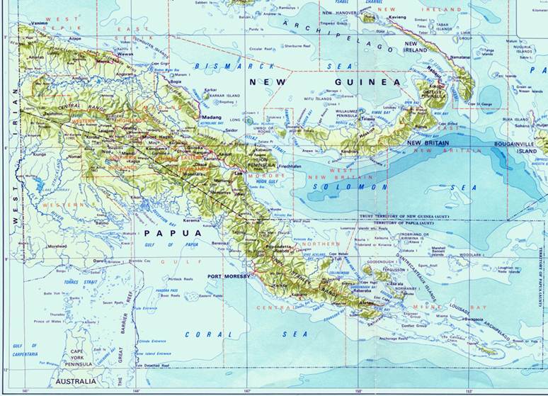
Annex
B: PNG High and Low Level Geodetic Network
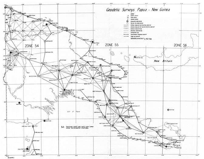
Annex
C: Army Aerodist Network