|
| Home |
| People |
| Photos |
| Videos |
|
Documents
This is were you will be able to find
Historical |
Recollections |
Published documents of interest |
Historical
- History of New Guinea Survey Section, later 2 Field Survey Section, 8 Australian Field Survey Section, AIF, compiled by Jack Viccars, one of the members of that unit in 1987, from members' memories and stories (courtesy Peter Jensen). Male staff at Port Morseby with the Commonwealth Department of the Interior, from which National Mapping later emerged, were among the initial civilian members of the survey unit.
- High Level Geodetic Survey of New Guinea, Technical Report No. 8, March 1969, by H.A. Johnson.
- Crustal Movement Survey Markham Valley, Papua New Guinea 1973, Technical Report No.18, 1974, by Cook, David P and Murphy, Brian A.
- Crustal Movement Survey - Markham Valley, Papua New Guinea 1975, Technical Report No.23, 1976, by Sloane, Barry J and Steed, James B.
- Crustal Movement Survey - St. Georges Channel, Papua New Guinea 1975, Technical Report No.24, 1976, by Sloane, Barry J and Steed, James B.
- Special Report of Results, Australian Controlled Territory, Southwest Pacific Survey, Project AF 60-13, 15 January 1965, 1370th Photo-Mapping Wing, Air Photographic and Charting Services (MATS), United States Air Force. At this time only Volumes 1 and 3 of 3 are available (if a copy of Volume 2 can be located it will be added). This project involved the connection of the primary survey system of Australia to New Guinea and outlying islands. The project used the Hiran system of aerial electronic surveying, and was carried out during the period September 1962 to June 1964. The report contains black and white photographs of survey stations and the quality varies and the area sketchs are distorted but still clearly readable. A zoomable map showing the HIRAN network can be viewed here.
Recollections
- Christmas 2013 marked 50 years since Ed Burke, Guy Rosenberg and Ron Scott enjoyed a white Christmas on the summit (approx. 15000ft) of Mt Wilhelm, Papua New Guinea. Photos from 1963 and 2012 can be viewed here.
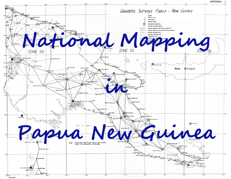
- The Division of National Mapping's Geodetic Survey of Papua New Guinea -
A Personal Perspective is written by John Allen & David Cook to document a "gap" in the history of Napmap's work there.
While National Mapping's geodetic survey of Australia is recognised as a great achievement, its survey of Papua New Guinea (PNG), however, undertaken with Army and PNG cooperation, is less well known. This paper, based on the authors' recollections of the survey, provides an insight into the unique demands of this project from a personal perspective.
Photos courtesy of Ed Burke, Dave Cook, John Allen, Bob Goldsworthy & Bruce Willington showing aspects of the Geodetic and Border surveys in PNG
- A "Flashback" from Ed Burke about flying to and from PNG for the geodetic survey, before the "jet age".
Published documents of interest
- John Macartney's 1968 paper describing the Survey of International Border between West Irian and the Territory of Papua and New Guinea (reproduced with permission).
- Information from a number of known and unknown sources describing the Joint Indonesian and Australian Survey of the border between West Irian and Papua (compiled by Paul Wise) New Guinea.
- Further documents from the Internet relating to the border.
- The U.S. Air Force Southwest Pacific Survey which established the principal islands of the Southwest
Pacific area on a common geodetic datum including connecting New Guinea and the adjacent islands to the geodetic network on the mainland of Australia.
|
|