Anniversary Nunataks Survey January 1968
By John Manning February 2018
Introduction
The successful completion of the Mount Twintop to Depot Peak survey traverse was concluded on 30 December 1967 with the delivery of fuel drums to Depot A and Depot B.
This almost completed the ground survey program for the 1967 year which had been put on hold while the major Church Mountain traverse was carried out. As a consequence, the remaining survey items in the Framnes Mountains were planned to be undertaken with helicopter support during the 1967-68 changeover. These would extend the existing geodetic network from stations at Lucas Nunatak, and south from Onley Hill to McGrath Nunatak, Van Hulssen Nunatak to Mt Twintop.
With warm mid-summer weather at Mawson, the base was in a lethargic mood with a focus on preparing for the impending changeover. The Nella Dan had reached Sandefjord Bay and the helicopters were establishing a wintering glaciology base on the Amery Ice Shelf headed by surveyor Max Corry. In addition, a start was made on an unconnected (floating) survey traverse along the coast nearby and extending down the east side of the Amery Ice Shelf.
The good progress of the helicopter supported work on the Amery Ice Shelf was being monitored. However, the surveyor retained memories of the difficulties encountered in the previous (1966‑67 Mawson) changeover. Thus he was keen to take advantage of the summer weather to reduce the later dependence on helicopter support during the coming changeover.
With a lot of goodwill from the Mawson personnel, a field party was finally arranged to cover some of the more distant and difficult survey legs in the Framnes Mountains. Again there was a reliance on the light Snow Trac vehicles. But this time heavy sledges were not used and most equipment and stores were carried on the vehicles.
The following field report is the surveyor’s account of that work, written at Mawson while awaiting arrival of the changeover ship. It was the final survey work completed by ground survey that year. The subsequent internal polygon figure around Van Hulssen Nunatak was successfully measured with helicopter support during the 1967-68 changeover following the arrival of the Nella Dan at Mawson later in February 1968.
McGrath Nunatak is one of the Anniversary Nunataks which were named after an astrofix was obtained there by surveyor David Carstens on Australia Day 1963; the anniversary of the first permanent European settlement in Australia. Located at 68° 03’ South 63° 01’ East, the Anniversary Nunataks are some 22 miles south of Onley Hill, see map below. Following Carstens’ 1963 work the area was next visited by surveyor Max Corry in the Spring of 1965. (Details of Max Corry’s work are provided in his Survey Report: Mawson 1965 at this link and in the entries for 20 and 21 November 1965 from his Survey Log: Mawson 1965-1966 at this link.)
Field Report No.18: Anniversary Nunataks Survey Trip January 1968
Objectives
Erect a survey beacon at McGrath Nunatak. Complete an external Tellurometer loop of the Framnes Mountains with horizontal angles and Tellurometer measurements:
· McGrath Nunatak to McNair Nunatak
· McNair Nunatak to Onley Hill.
January 1968 Personnel
John Manning Surveyor
Bill Butler Senior Diesel Mechanic
Mark Forecast Weather Observer
Syd Little Electrician
Tony Jacques Weather Observer (withdrew after first vehicle repair at Mawson)
Transport
Snow Trac No.7 and Snow Trac No.8; with Snow Trac No.7 pulling a ½ Norwegian sledge with fuel, beacon and spare parts.
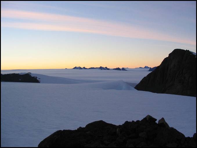
Onley Hill (at right) looking south west from Mount Henderson to the Central Masson Range in 2003. Mel Fitzpatrick image from Australian Antarctic Data Centre website (catalogue IA16474).
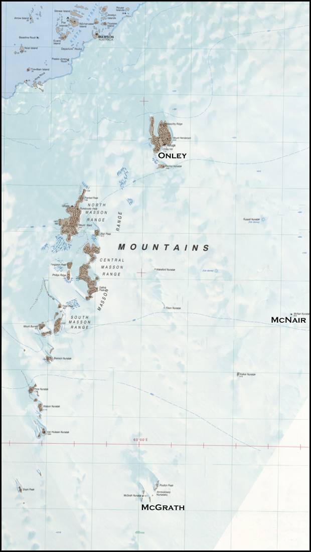
Stations occupied on January 1968 Anniversary Nunataks Survey.
Manning Diary Extracts
8 January 1968
The Snow Tracs were packed as separate survey and survival units, each one with a tent - Beche or Polar Pyramid. Theodolites and Tellurometers were carried in padded boxes as usual on the seat behind the driver, packing was completed soon after tea and as weather was fine a start was made that night.
Left Mawson at 2100 with Syd and Tony in No.8 and Bill and myself in No.7. Good steady progress was made through the gap between Onley Hill and Fischer Nunatak around the south and west of Russell Nunatak to reach McNair Nunatak at 2330. Without stopping we continued on about 260° true along the obvious line between crevassed domes for about 4 miles and swung southwards only to encounter crevasses on high ground.
Swinging back north and then west another small crevasse field (visible) on hard snow and ice was crossed to position 63° 07E 67° 53S where a marker flag was placed in a safe shallow valley and a 60° turn made towards McGrath Nunatak (being now clear of high ground which was previously encountered).
After starting off again at midnight the rear idler pivot shaft broke on Snow Trac No.8 leaving no alternative but to return to Mawson to repair it.
Stripping the broken rear idler we left the vehicle standing there, with visibility so good decided to make a direct route back and headed for Onley Hill.
After crossing two fairly bad areas of scattered visible slots on ice, we reached the broad valley south of Fischer Nunatak and continued through the Fischer-Onley gap to arrive at Mawson at 0330 on 9 January with no trouble at all.
9 January 1968
With rear idler pivot shaft repaired and taking a spare as well the four of us set out again at 1300 but after 50 yards No.7 centre bogey collapsed (lock sheared allowing pivot pin to work out twisting its hanger).
The Snow Trac was carefully driven into the workshop and repairs to damaged bogey and track bogey pivot pins all effected. Worn tyres were changed and guide rails checked. Tony Jaques withdrew from the trip and eventually replaced by Mark Forecast.
Starting out again at 2100 with Mark driving and Bill, Syd and myself as Passengers, a trouble free run was had through the Fischer‑Onley gap and a direct route steered towards the broken down Snow Trac No.8.
10 January 1968
As the going was uphill the various small domes were more apparent than last night and only one visible shattered ice slot area was traversed. About 2 miles from the depoted vehicle, Mark lost response on the steering and inspection revealed that the split pin was missing from left hand front axle and the castellated nut had worked loose. This trouble was soon rectified and Snow Trac No.8 was reached at 1130.
Working in the lee of the other vehicle, the rear idler was soon fitted and we were in business again, driving almost directly into the sun which was low in the sky, making visibility a little poor.
Passing a low but sharp dome on the immediate east, a trouble free run was had to arrive at McGrath Nunatak parking just below rocky top at 0130. With a very cold wind blowing the beacon (a double drum type) and survey equipment were taken up to the summit. The vehicle was refueled and Bill and Syd left in No.8 at 0230 for McNair Nunatak with rearranged radio and Telle skeds. A radio sked at 0530, revealed that they were established on McNair and all set for Tellurometer measurements. These were successfully completed, but due to immense conditions of refraction and gale force winds on McGrath especially, no vertical angle observations were possible.
Intermittent trouble was encountered with MRA 360 when operating on Master sequence but with careful use, tuning by ear could be achieved when the main monitor was not working.
On closing down equipment, further radio skeds were arranged and Bill and Syd were to proceed to Onley Hill, whilst Mark and I proceeded to McNair. Completing the beacon guying at McGrath, we packed the gear down to the Snow Tracs and started off. After 50 yards, Mark and I ran into trouble on No.7 when the steering failed and acted eccentrically.
Careful examination of the variator belt assembly, pulleys and drive chains revealed nothing, but eventually the trouble was seen to be on the left front axle where the axle spindle was failing to turn the female spline of the sprocket hub. The bearing had collapsed, the spline on the axle was considerably worn and the castellated locking nut too loose to hold the spare sprocket hub against the collapsed bearing.
After some 4½ hours work, Mark’s ingenuity and mechanical knowledge succeeded in effecting repair. After an hour’s trial run up to the marker flag, it was decided to go ahead to McNair as repair was proving to be very good.
· ·
Arrived
McNair 1600, after changing a rear blown tyre. Tellurometer contact established
at 1700. The monitor meter on MRA 360 was malfunctioning all the time now but
readings were carried out successfully by using tuning on the remote monitor,
being talked in to the master operator on a speech channel which was weak but
normal. Considerable ground swing, similar in both directions was obtained in
the measurements but it was impossible to effectively screen the instruments
from the intervening ice terrain (ice not snow).
On completion of Tellurometer distance measurements, vertical angles and then horizontal angles were read. Leaving McNair at 2030 and driving back on original outward tracks to the north of Russel Nunatak we reached the Fischer-Onley saddle at 2115 where Syd and Bill were waiting in the other Snow Trac.
A trouble free run was then had back to Mawson; arriving there at 0030 on 11 January 1968.
General Summary
After setting out the second time, the entire trip was carried out in some 27 hours continuous work and travel. This reflects much credit to the competence and ability of the support I received being prepared to do the maximum possible while the good weather lasted. It was found that if care was taken a good crevasse free route to Anniversary Nunatak exists.
Briefly described this route is: head along old vehicle route north of Russell Nunatak to McNair then head generally (262°T) towards Mt Horden for 6.5 miles to a marker flag, turn and head (about 200°T) to McGrath Nunatak along the valleys. The direct route Onley to 63° 07E; 67° 53S is reasonable with care but not recommended because crevasse zones which are hard to avoid even in good weather.
The objectives of the trip were successfully carried out with Tellurometer distance measurements and a rock filled double drum beacon, guyed at the top, erected at McGrath Nunatak on site of an old vane beacon.
Horizontal angles were also read at McNair Nunatak (2 sets with T3 each to Onley Hill, Van Hulssen, Twintop and McGrath). No theodolite work was possible at McGrath because of gale force winds and severe refraction.
At this time of the year expedition station life is somewhat preoccupied with the impending arrival of the relief ship and I would particularly like to thank the personnel concerned with this trip for sparing their time and giving such fine assistance to make the trip a successful one. It is very much appreciated.
Signed
John Manning
Surveyor Mawson
10 February 1968
Author’s Hindsight Note: 10 February 2018
This trip demonstrated the great expertise developed during the whole year with vehicles, equipment and a careful reading of the terrain. With the bonus of 24-hour daylight and good weather the only limiting factor was the expertise and physical capacity of the participants. All members showed remarkable energy, ability and endurance. But especially for Bill Butler, the Senior Diesel Mechanic, to stand in, support me and personally take on the field responsibility for aging vehicles enabled this work to happen. Bill you are still a gem!
Conclusion from Beyond Mawson
The Anniversary Nunataks trip ended the ground survey field work for the 1967 wintering surveyor. Personally it had been a year of achievement and frustration. My work and attitude was strongly supported all year by John Erskine, the Officer‑in‑Charge at Mawson who somehow received scant praise for the difficult management task he had. This was exacerbated by the impact of the medical situation, caused by the hopelessly incompetent Doctor James Carnegie. All expeditioners who left the comfort of the base to support me on the field trips gave their best effort in dangerous terrain and severe weather conditions but others would not leave base in case of injury.
The Nella Dan arrived Mawson in February 1967 carrying three Fairchild Hiller FH 1100 jet engine helicopters on contract from Helicopter Utilities Pty Ltd. These helicopters were employed to complete the measurement of the Framnes Mountains geodetic network. An internal polygon figure centred at Van Hulssen Nunatak was observed with lines and angles to McGrath, Onley Hill, McNair and Twintop. Then a drum beacon was erected Lucas Nunatak together with further angular work.
This completed all outstanding survey work to be done directly from Mawson. The inland fuel depots were prepared for the new focus for survey and geology work to be moved to the mountains in intensive blitzkrieg style operations in the short summer period.
For the surveyor there still remained a massive office calculations task to clean up. This involved assembling all the old offshore triangulation work of the early surveyors (1954, 1959 and 1962). This early data then had to be integrated into the Tellurometer-based geodetic quality work from 1962 and 1965. Following this a new origin had to be calculated and the overall network then adjusted based on the 1967 work.
Beyond the helicopter work and completing the Framnes Mountains surveys at the Mawson during the 1967-68 changeover, new tasks were requested by Natmap. One was to undertake what was to be the last astrofix used for Australian Antarctic mapping, it was located on the west side of the Amery Ice Shelf. This location was reached by long flight in helicopters from the Nella Dan in Prydz Bay. However, navigating and finding a photo identifiable location on the side of the Ice Shelf was difficult when flying into the sunset on the evening of 28 February 1967. For the astrofix, 12 stars were observed using the Ney Method at a place identifiable on an ice feature now named as Twilight Bay. (Located at 68° 32' South 69° 48' East, this Bay was so named because, as mentioned, our February 1968 survey party was flown into the area after sunset necessitating navigation and photo identification in the twilight.)
It was a bit emotional farewelling the ingoing Amery party, the next day from the ship, particularly surveyor Max Corry. I would have dearly loved to have stayed with them for another year on such an exciting project. En route to Australia the ship called at the under construction new Casey station. We had onboard Commander Austin Yeager of the United States Coast and Geodetic Survey. He was to select a site for a survey station to be occupied in 1969 for the worldwide Pageos (passive geodetic earth orbiting satellite) project. This space geodesy project, would use the satellite and stellar triangulation to determine a figure of the earth. This would be achieved by simultaneously photographing the 30-metre Pageos balloon satellite on photographic plates against a star background to link adjacent Pageos observation stations in a global network.
During the Mawson changeover. Commander Yeager had earlier selected a similar Pageos site and I had provided a position and observed a strong star azimuth. At Casey several days of blizzard interfered with positioning and azimuth determinations at the site.
The Nella Dan waited off shore for the weather to clear. The surveyor remained ashore and was usefully employed as cook for the construction crew before the site was eventually marked and an azimuth observed.
Further towards to Australia the ship encountered bad cold weather which caused widespread icing. Previously at Mawson the surveyor sought to have the survey equipment specially treated on the return voyage. It was carefully loaded and placed in a special small hold where the mail was usually carried and the surveyor relaxed for the trip home.
In the rough cold weather, however, water pipes burst on the ship and all the beautiful Tellurometers in their wooden transit boxes were floating upside down in the water. (Together with the surveyor’s collection of personal photographic slides). Eventually the Nella Dan reached Hobart for unloading on 19 March 1968. Only then was I able to see my five month old second daughter for the first time. But at that young age Tonya was not impressed with the unknown, wild looking, bearded explorer and screamed continually; a smart girl I thought.
John Manning