Field
Operations 1959
The 1959 program was to be:
(i)
Reconnaissance - finalisation of Carnegie -
Roy Rill section under H.A. Johnson
(ii) Reconnaissance
- Kalgoorlie - Mt Deverall, WA and Mt Fanny, WA - Hardy, NT, under A.H. Spowers
(iii) Beaconing
and observing, Mt Hinckley - Carnegie - Roy Hill, WA, under R.A. Ford
(iv) Beaconing
and observing, Derby area (Mt Anderson - Halls Creek, WA) under R.A. Ford
(v) Observing
Colona SA - Eucla (Wilsons Bluff), WA,
under A.H. Spowers
(vi) Observing
and Tellurometer, Tower Traverse, Mataranka ‑ Powell Creek, NT, under A.H.
Spowers
(vii) Tellurometer
measurements, Ooldea, SA - Colona, SA - Olwolgin Bluff, WA, under M.A. Nicholas
(viii) Tellurometer
measurements, Mann. Range - Roy Hill and Mt Anderson - Halls Creek, WA, under M.A.
Nicholas
(ix) Reconnaissance
Mildura, Vic - Tibooburra, NSW with some Tellurometer measuring under M.A.
Nicholas
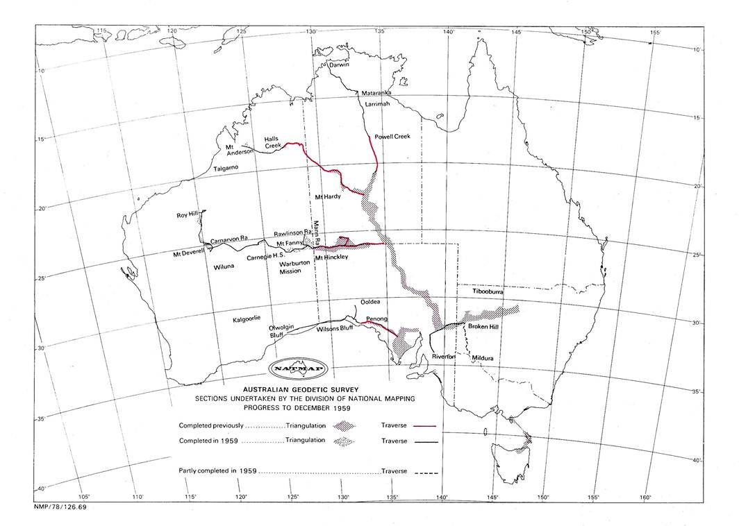
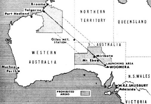
This was an important year for the
Division and also for WRE. The requirement was that the big 2700 mile loop of
traverse, Alice Springs - Finke - Giles - Rawlinson Range - Roy Hill - Derby -
Halls Creek - Alice Springs, had to be completed by the end of 1959 to provide
the required control at Talgarno (between Broome and Derby), in time for the
firing of the “Blue Streak” rocket in 1960. Of the 2700 miles required, the
Division had completed approximately 1100 miles during 1957 and 1958. The 1959
program would require the Division to complete a further 1100 miles, and the WA
Lands approximately 450 miles - between Roy Hill and Mt Anderson. All involved
could see there was no time to spare if this program was to be successfully
completed to the required timetable.
Central
and Northern WA Field Work
The field party under R.A. Ford left
Melbourne early in April and in Adelaide was joined by the WRE vehicles and
drivers. It then proceeded to the Giles area; as all beacons as far west as
Warburton Mission, with the exception of Rawlinson Range had been erected in
1958, observing was commenced at Mt Hinckley. Only two observers were
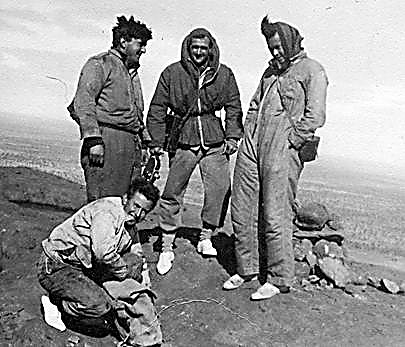
available, R. Ford and G. Cruickshanks. The observing party at Rawlinson Range
built this cairn while at that station. Lights were necessary on the long lines
Rawlinson Range - Mt Aloysius (71 miles) and Rawlinson Range - Mt Fanny (57
miles).
It was a triangulation scheme to the
line Mt Talbot - Scamp Hill, near Warburton Mission.
However the observing conditions
were good and in conjunction with the work of the previous year at the junction
stations, 34 triangles were closed at an average misclosure of 0.54 second,
only four triangles having over one second misclosure with the
greatest 1.38 seconds. It was pleasing to get such good results on probably the
last main triangulation chain National Mapping would observe in Australia. This
work was completed by the end of May. See Figure 1 for triangulation
diagram.
The
field party now prepared for the difficult country ahead. A contractor
had dumped petrol in 44 gallon drums at both Warburton Mission and Carnegie HS
for the use of all National Mapping field parties passing through. The vehicles
were refuelled and water was taken on at the Mission, all extra vessels
available were filled. As cairns had to be built and lines cleared a beaconing
party with E. Lewis in charge was organized and moved off ahead of the two
observing parties which were each of two men.
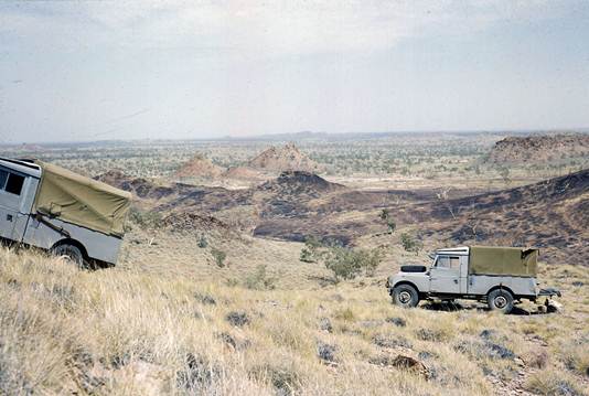
The
track was a mixture of soft and hard spots, hard being the area
where white ants nests had stood before being removed by the grader; this made
travelling very slow however it was a lot better than just wheel tracks and as
movement was only between a couple of traverse stations at a time, travelling
was no great strain. H.A. Johnson, coming from WA where he had just completed
the reconnaissance Carnarvon Range to Roy Hill, passed the party at Mt Everard,
handing over the access sketches of that section.
A little later A.H. Spowers who had just completed the
reconnaissance Kalgoorlie to Carnarvon Range passed en route to Giles. It took
only four weeks to completely beacon and observe the 16 stations in the section
Warburton Mission to Carnegie H.S. As the only water available
was that carried on the vehicles, consumption of it had to be carefully watched; no
washing of clothes was possible and baths were little more than a wipe down
with a wet facecloth. The date of arrival at Carnegie HS was 22 June.
Two
beaconing Parties were now organised and the nine hills west to Mt Salvado in
the Carnarvon Ranges, were beaconed. The observing then commenced working east
towards Carnegie HS. All observing was completed by 9 July and the
field party proceeded to Wiluna next day. This was the first place visited
since passing through Kulgera on 18 April which had a general store where
supplies could be purchased.
One
week was spent in Wiluna getting vehicles repaired, purchasing food
and petrol etc. In preparation for the next section a beaconing party under. E.
Lewis was organised to push ahead quickly to Roy Hill, as M. Nicholas with the
Tellurometer had almost caught up, and by the very nature of that work would
soon pass the observing party and continually widen the gap. Also Frank
Johnston a surveyor from the Snowy Mountains Authority, who was doing Laplace
observations along the traverse for the Division, arrived at this time and
would need to observe at some of the stations yet to be established between Carnarvon
Range and Roy Hill.
In the
Carnarvon Range area the scheme was again minor triangulation, however the
observing conditions were good and all observing was completed to Roy Hill by
the end of August. The Tellurometer party had been delayed by instrument
trouble and were still behind but F.L. Johnston had moved well ahead as the Laplace
stations were widely spaced.
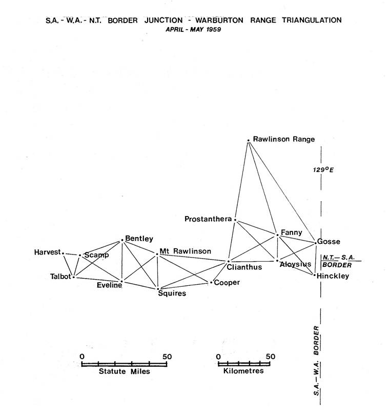
Figure
1: Triangulation scheme NT/SA & WA Border – Warburton.
The
beaconing party had already gone ahead to beacon from Mt Anderson
to Halls Creek. The observing parties followed and arrived in the area
on 4 September and built the cairn on Erskine Range, this task having been
left to them to enable the beaconing party to keep well ahead. Observing commenced
but conditions on this section were to prove most difficult, the wind was
strong, causing a constant build up of dust haze by evening.
Some
observations were done at dawn to circumvent this problem; heliographs and lights
were necessary on some lines. The Tellurometer party caught up again and
completed their measuring a few days before the observing was finalised. All
was finished by 30 September which meant the big loop required by WRE had been
completed.
The
field party commenced the return trip to Wiluna, R.
Ford called at Talgarno to advise T.R. Nossiter (OIC Engineering
Reconnaissance Section, WRE) of the completion of the field work and also to
contact M.A. Nicholas regarding future plans. T. Nossiter was full of
enthusiasm at the successful completion of the survey and spoke of a big
program of mapping in the Talgarno area which they considered requesting the
Division to do in 1960.
The
party arrived back in Wiluna on 12 October. The balance of the season's
work was to be the beaconing of the Carnarvon Range - Kalgoorlie traverse.
Beacon poles, paint and cement etc., which had been ordered as the party passed
through Wiluna in July, were waiting to be collected. It was very hot now, unfortunately there was a huge amount of tough mulga to
be cleared on the first few hills which were flat topped. To beat the heat,
work was commenced at first light with a lay-off during the hottest part of the
day, followed by a few more hours work in the evening. Once the beaconing was
proceeding well, R. Ford returned to Melbourne by road, arriving 2 November. G.
Cruickshanks took charge of the beaconing party and all beaconing and clearing
was completed before the field party returned to Melbourne.
Southern WA observing and NT Tower
traversing
The
field party under A.H. Spowers left Melbourne in April and completed
the Colona - Wilsons Bluff and Colona Ooldea observing. Conditions were
difficult at the stations sited on the “capes” along the cliff-edge, some of the lines were long and low over
the water making lights necessary. R. James and H. Couchman were the
observers on this traverse. In conjunction with this work, A.
Spowers completed the reconnaissance, Kalgoorlie to Carnarvon Range.
Closing
down in this area the party returned to Adelaide, collected the
thirty foot observing towers, scaffolding and other sundry requirements, then
moved by road to the Mataranka area of the Northern Territory.
During
this time A. Spowers travelled via Carnegie homestead to Giles and reconnoitred
a connecting traverse from Mt Fanny to Mt Hardy on the Aileron
- Halls Creek traverse. He then proceeded north to join the observing party at
Mataranka and to take charge of the work on the tower traverse.
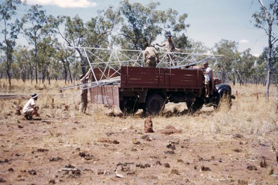
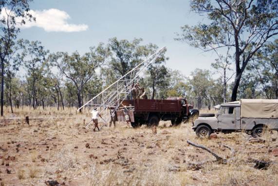
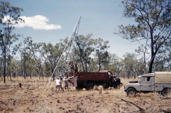
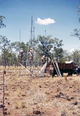
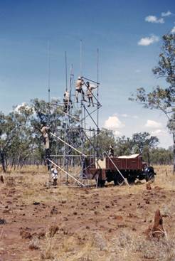
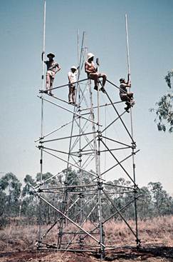
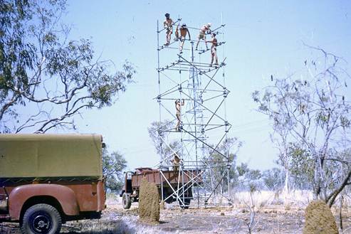
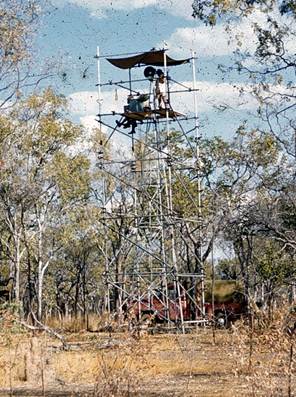
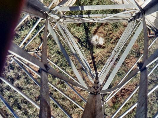
The
observing towers were orthodox thirty foot tripod windmill towers. A circular
steel plate attached to the top of the tower held the instrument, this plate
taking the place of the normal tripod head, the only difference
being there was no “traversing” movement to assist in plumbing the instrument.
On this traverse, the towers and scaffolding were positioned and then
the station mark was established directly below the plumb point of the instrument.
Normal “Mills”
tubular scaffolding was used, however the eleven and eight feet lengths were of
dural tubing not steel; because of the lighter material this made it possible to carry
sufficient scaffolding in two 3 ton trucks. A heavy bond wood platform was
provided for the observer and booker; it was possible to adjust
the platform to suit the height of the observer.
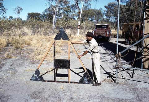
All observations were to lights
after dark, it taking about half an hour after sundown for the tower to cool
down and become stable enough for observations. A Tellurometer was with the
field party so that all work could be completed at the station before the tower
and scaffolding was dismantled and moved to a new site.
Unfortunately only one night's observations
were taken at all stations and only one measurement on quite a large section of
the traverse. As by this time it was late in year, the weather was very hot in
that northern latitude and both observing and living conditions were difficult.
Towards the close of the survey, O.J. Bobroff, a Surveyor Grade 2, who had
recently joined the Division arrived to familiarise himself with the equipment
and the technique. Also during this period some rock cairns complete with pole
and vanes were erected on a few previously observed stations just south of
Darwin. When the traverse was completed the tower equipment was stored and the
field party returned to Melbourne in December.
Tellurometer
Party
M.A. Nicholas was in charge of the
main Tellurometer party. They completed all measurements on Olwolgin WA -
Colona SA and Colona - Ooldea SA traverses, some 450 miles in all.
The party then moved to the WA-NT-SA
border area and completed all measurements to Roy Hill. Instrument trouble
occurred on the last section which follows the Great Northern Highway and the
instrument had to go to Perth for repair. It was lucky no similar problems had
been experienced while measuring between Giles and the Carnarvon Range. On the
return of the instrument the traverse was completed to Roy Hill, 800 miles in
all being measured.
The next move was to the Derby area
and 250 miles of traverse was measured between Mt Anderson and Halls Creek.
This was completed by 30 September.
This field party now returned to
Melbourne and after having their vehicles and instruments serviced proceeded to
Mildura. From here to Broken Hill a traverse was reconnoitred, stations marked
and most of the lines measured. No theodolite observations were undertaken and
a small section where towers would be necessary had to be left until tower
equipment could be brought to the area at some later date.
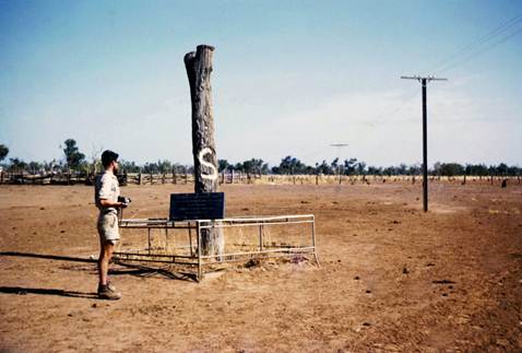
Reconnaissance only, was undertaken
northward from National Mapping's 1954 station, Gap (come 70 miles north of
Broken Hill) almost to the Queensland border. The party returned to Melbourne
in December.
During the year a National Napping
field party also measured 250 miles of traverse between Riverton, SA and Broken
Hill, NSW. Selected sides of the Division's 1954 triangulation scheme were
measured to form the traverse, no angular measurements being necessary.
Early in the year C.K. Waller who
had pioneered the use of both the Geodimeter and Tellurometer resigned to join
the Queensland Department of Lands in Brisbane, his home town.
Other
Reconnaissance
H.A. Johnson completed the Carnarvon
Range - Roy Hill reconnaissance, visited the observing party at Mt Everard and
inspected the track which he had marked twelve months earlier for L. Beadell's
grading team.
In the spring he went to Papua New
Guinea and commenced a reconnaissance for a triangulation scheme through the
high mountain ranges of that country. Many high peaks of the Owen Stanley
Ranges were climbed on foot, lines were cleared where necessary, and large high
cairns with a fourteen foot steel pole and vanes were erected. Full details of
this reconnaissance are available in his report, “High Level Geodetic Survey of
New Guinea”, Technical Report No. 8, March 1969.
Summary
A huge amount of traversing was
completed this year; with the Tellurometer measuring catching up to the
beaconing and observing, much more work was fully completed than was the case
in the previous year.
However the biggest let down was
that after all the effort to complete the traverse loop to provide control at
Talgarno for the “Blue Streak” project, the British Government announced that
project's cancellation just as the field party arrived back in Melbourne.
Probably the Geodetic Survey of Australia came out best; it is most unlikely
money would have been available to push the survey ahead at such a fast pace if
it hadn't been for the “Blue Streak” requirement.
Details of traverses completed in
1959:
|
Mataranka - Powell Creek, NT |
240 miles - 51 stations approx. |
|
Mt Anderson - Halls Creek, WA |
250 miles - 16 stations approx. |
|
WA-NT-SA border - Carnarvon Range
- Roy Hill, WA |
800 miles – 58 stations approx. |
|
Ooldea, SA - Colona, SA - Olwolgin
Bluff, WA |
450 miles (mainly measurements) |
|
Riverton, SA - Broken Hill, NSW |
250 miles (measurements only) |
|
Mildura, Vic - Broken Hill, NSW |
200 miles (measurements only) |
Field
Parties 1959
|
H.A.
Johnson |
Senior
Surveyor, Reconnaissance |
||
|
|
|
||
|
Central
and Northern WA |
|||
|
|
|||
|
R.A.
Ford |
Surveyor,
Grade 1 (Acting) |
||
|
G.J.
Cruickshanks |
Field
Assistant (Survey) |
||
|
E.
Lewis |
Field
Assistant (Survey) |
||
|
J.
Graham |
Field Assistant |
||
|
J.
Coles |
Field Assistant WRE |
||
|
R.
Campbell |
Field Assistant WRE |
||
|
G.
Stanley |
Field Assistant WRE |
||
|
R.
Hair |
Field Assistant WRE |
||
|
E.
Skeen |
Field Assistant WRE |
(short time only) |
|
|
|
|
||
|
Southern
WA & NT |
|||
|
|
|
||
|
A.R.
Spowers |
Surveyor
Grade 2 |
||
|
R.
James |
Field
Assistant (Survey) |
||
|
H.
Couchman |
Field
Assistant (Survey) |
||
|
K.
Simonds |
Field Assistant |
||
|
C.
Hale |
Field Assistant |
||
|
D.
McDonald |
Field Assistant |
||
|
H.
Bausor |
Field Assistant |
||
|
O.J.
Bobroff |
Surveyor
Grade 2 |
(NT section only) |
|
|
F.
Dare |
Field
Assistant (Survey) |
||
|
J.
Marshall |
Field Assistant |
(NT section only) |
|
|
|
|
||
|
Tellurometer Party |
|||
|
|
|
|
|
|
M.A.
Nicholas |
Surveyor
Grade 2 |
|
|
|
R.
Collins |
Field
Assistant |
|
|
|
J.
Marshall |
Field
Assistant |
|
|
|
D.
Hutton |
Field
Assistant |
|
|
|
E.
Skeen |
Field Assistant WRE |
(SA-WA only) |
|