THE BEAVER LAKE 1:100 000 SATELLITE IMAGE MAP
Manning, J. and Rogers, P.
(Cartography 1990, Vol.19, No.2, pp.11-13.)
ABSTRACT
Mapping in Antarctica presents a technical challenge to the cartographer. There is very little aerial photography available, and only a limited amount of ground control. Satellite imagery and positioning from satellite systems such as Transit (Doppler) and Navstar (GPS) offer a means of economically producing selected mapping products for areas of special interest to scientists in the Australian Antarctic Territory.
In the 1970s a black and white dyeline image series over parts of this territory was made by photographic mosaic techniques from Landsat Multi-spectral imagery. The results were often poor and presented the user with interpretation problems in differentiating between water, blue ice, low sun shadow areas and rock features.
Now, using state of the art digital techniques, a sharp, fully colour saturated product can be produced which correctly depicts the terrain.
Background
Digital satellite imagery can be geometrically and spectrally enhanced on many image analysis systems, but a problem arises when there is the requirement to produce quality copies of the displayed digital data. Some common methods available are:
- Photograph the screen display and make photographic enlargements
- Use a film writer to produce a small negative or positive transparency
- Inkjet plots
- Electrostatic plots
However, each of these methods has inherent disadvantages and are not suitable to produce thousands of copies of a high quality product to a uniform standard.
The traditional cartographic approach is to print multiple copies by photo-lithography which usually involves scanning composite colour transparencies or prints produced on a film writer. These conventional techniques were initially used by AUSLIG to produce full colour satellite image maps of Antarctic from SPOT imagery (Lindsay and Manning 1989). The maps produced were:
* Larsemann Hills 1:25 000 Edition 1 1988
* Windmill Islands 1:50 000 published 1989
* Framnes Mountains 1:100 000 published 1989
The information portrayed on these maps was quite good and provided an adequate solution for urgently needed cartography in these remote areas of Antarctica. However, the image resolution had been significantly degraded during the scanning/colour separation and printing processes. This degradation and clarity can be seen when compared with the original image/data when it is displayed on the computer screen. Image quality problems of this nature are often encountered with the output of enhanced imagery from computer systems.
The SIMAP process
To tackle the degradation problem, AUSLIG, in conjunction with two Australian private sector firms, Laser Graphics and Beaver Press, developed direct lithographic printing from digital data. This technique eliminates much of the image deterioration associated with scanning and enlarging from hard copy imagery normally used in cartographic production of this type.
In the SIMAP process the digital satellite imagery is corrected geometrically and fitted to ground control. The information on the image is then spectrally enhanced by computer techniques to highlight the required features. The digital data is then reformatted to expand or reduce the 256 grey scale increments making it suitable for subsequent transfer to a graphics art scanner/plotter computer system. The colour balance is customised in this raster system, before the plate-making film is produced by a laser plotter. After combining manually produced surround details and vector information, careful printing is undertaken to match an approved colour proof using dot screens between 175-200 dots per inch. Choice of dot size is governed by the type and quality of paper.
This process now has the registered trademark name of SIMAP (Satellite Image MAPping). The improvement in detail and resolution quality achieved by this process is quite significant, not only is the resolution better on the SIMAP products but the colours have been carefully controlled to highlight important features.
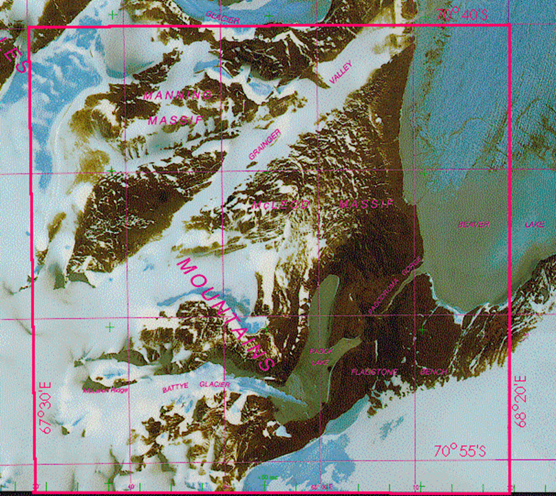
Section of Beaver Lake image map produced by SIMAP process.
Production of the Beaver Lake Map
The SIMAP technique was developed and applied in the production of the Beaver Lake Satellite Image Map. Initial ground control was a combination of a primary triangulation/ tellurometer network and recent Doppler satellite position fixes.
The digital imagery data set was mosaiced to fit the control on a DIPIX system at ACRES from two LANDSAT and two SPOT scenes. Spectral enhancement and grey level adjustments were then carried out and the digital data reformatted to be compatible with the Laser Graphics computer system. Colour balance enhancements were further undertaken. Film separation was produced on a laser plotter.
Next, names, highlighted features and map surround were combined with the image resulting in final plate making film used in the colour printing carried out on a fully computerised six colour printing press.
The immense quality improvement using the SIMAP method can be readily seen in two newer satellite image maps of Antarctica
* Larsemann Hills 1:25 000 Edition 2 1990
* Beaver Lake 1:100 000 Published 1990
On the Beaver Lake sheet, the success of this process in bringing out detail in the long shadows produced by high peaks and low sun angle is quite noticeable. A traditional line map has since been printed on the reverse side of the image map to provide a complete cartographic product. The line map will additionally be digitised to form the basis of a Geographic Information System as a scientific spatial archive.
Potential Applications of SIMAP
The SIMAP technique can be applied to the cartographic reproduction of all digital satellite imagery or digitised colour aerial photography and is an economical process as it eliminates several production stages in the photo lithographic process.
It provides a quick response method where multiple copies of a quality, up to date satellite map can be produced within days of satellite data acquisition. This has obvious application in producing up-to-date land-use information or providing low cost topographic maps in developing countries.
In Australia, AUSLIG has subsequently entered into a joint development agreement with a Sydney based firm, Laser Graphics to undertake mapping projects for clients, using the SIMAP process.
Further development is currently being investigated to include names, highlighted features and map legend details with the image at the colour separation stage. Investigation is also being made involving inputting data digitally from various mapping systems as well as printing with opaque inks.
SIMAP technique is now being applied to many other mapping products in Australia such as geological mapping, environmental monitoring studies, as background for tourist maps of National Parks and is being tested for aviation purposes providing additional navigational detail for Visual Terminal (Approach) Charts (VTC) for Australian airports.
References
Lindsay, G. K. and Manning, J. 1989 Satellite Imagery Mapping of the Larsemann Hills Antarctica. Proceeding of 14th World Cartographic Conference, Budapest August 17-24. International Cartographic Association.