WILD Heerbrugg Model T4 Universal Theodolite :
their known Australian history
by Paul Wise, 2021, updated 2022
Introduction
The Wild Heerbrugg T4 model theodolite was deemed the Universal Instrument given its ability to be used in both first order geodetic triangulation and astronomical observation. It was the largest and most precise micrometer theodolite ever made. The T4’s unique broken telescope design allowed comfortable sighting to the zenith (broken telescope meant that the image was not viewed directly in the telescope but was transmitted by a mirror, set at 45° at the intersection of the instrument axis, which broke the incoming light so the image could be viewed through the eyepiece placed at one end of the trunnion or horizontal axis as shown in the image below). The T4’s powerful telescope with 2 interchangeable eyepieces had a 60 and 80 power magnification, an inverted image, and there was no focus since the optics were permanently fixed on infinity.
Readings of both the horizontal and vertical circles were made with an optical coincidence micrometer giving the mean of the readings on each side of the circle. The T4’s 10 inch diameter horizontal circle was graduated at 2’ intervals and could be read directly to 0.1” of arc. The 5¾ inch diameter vertical circle was graduated at 4’ intervals and read directly to 0.2”. Sensitivity of its suspending level, and of the two Horrebow-Talcott levels which were supplied with the instrument was 1” per 2 millimetres. Sensitivity of the level for the vertical circle was 2” per 2 millimetres.
With the T4 it was possible to determine longitude to 0.01 seconds of time (about 5 metres), latitude to 0.2 seconds of arc (about 3 metres) and the azimuth to 0.3 seconds of arc. Far from being a light instrument however, the two sections of the instrument itself weighted a total of 107 kilograms; its tripod was a further 17 kilograms. Timing equipment for astronomical work could add a further 25 kilograms to the load.
Released in 1941, later in 1943, the Empire Survey Review contained a short article A New Theodolite by Wild, on the model T4 with a photograph of the instrument and a brief summary of it specifications.
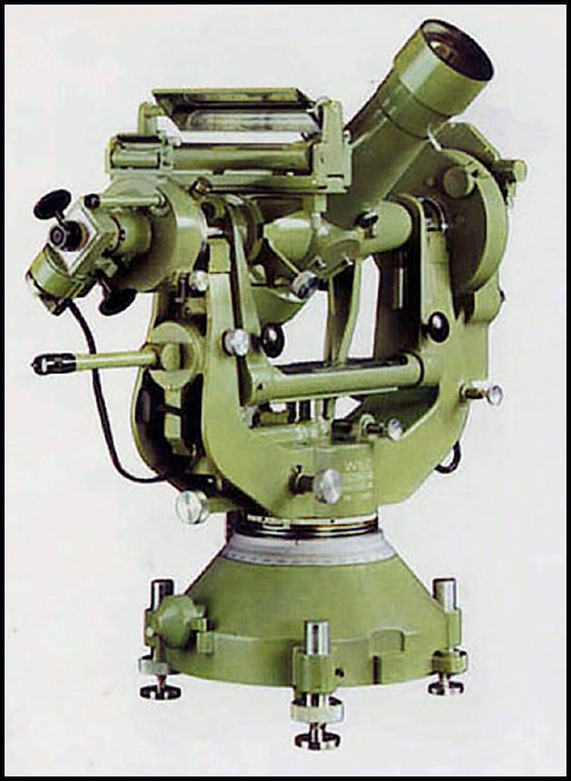
A Wild Heerbrugg T4 Universal Theodolite.
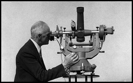
Viewing the image formed in the Wild T4 theodolite telescope via the eyepiece placed at one end of the trunnion axis.
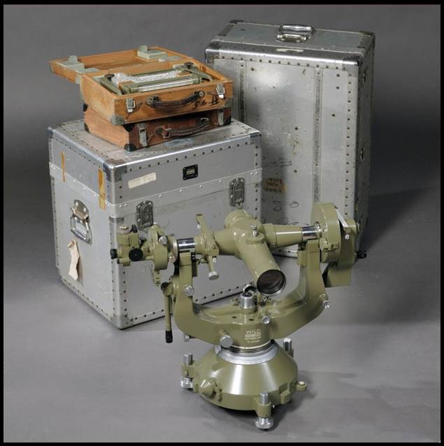
Wild T4 with its storage cases.
(images courtesy Wild Heerbrugg)
Between 1941 and 1966, Wild produced what it called its old style model T4. Production began on its new style model T4A in 1968 and ended in 1975. Then between 1977 and 1981, some modified model T4As were produced for the Defense Mapping Agency in America, which had a digital camera in place of the optical eyepiece. Wild itself reported that it produced a total of 439 model T4 theodolites between 1941 and 1981. Elsewhere, it was stated that a total of 357 model T4s were produced during the period 1941 to 1970, and it was estimated that less than 100 new style model T4s were produced in the years after 1970 including 12 of the modified T4As. In any case the model T4s used in Australia would have all been of the old style.
A little known but documented use of the T4 theodolite was for the determination of focal length and lens distortion from aerial camera calibration. The photograph below is of the Wild T4 goniometer from Spriggs’ 1964 paper Correlation of Data from Various Methods of Aerial Camera Calibration. Annexure A also contains more detail.
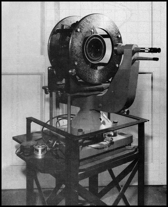
Wild T4 Goniometer for aerial camera calibration.
Wild model T4 theodolite use in Australia
From Ford (1979) and Johnson (1962), it is inferred that Wild model T4 theodolites were not used by the Australian State mapping agencies and in the main, the Wild T4 was only used for Laplace observations rather than for first order horizontal and/or vertical angles. National Mapping commenced its first order triangulation with the later Wild T3 model theodolite in 1952. This impression is partly confirmed by Stolz (1972) who stated that between 1957 and 1962 the T4 astronomic theodolite was used extensively at Laplace stations. The 1953 National Mapping Council of Australia, Standard Specifications for Horizontal and Vertical Control, provided information on the then frequency of Laplace observations in triangulation networks or along traverses. Johnson (1962), added that azimuths, Laplace controlled at each end, are now being established at least every fourth station on the National geodetic framework.
At least initially, the Royal Australian Survey Corps, and its predecessors, seemed to have used geodetic theodolites of English manufacture, like the Cooke, Troughton and Simms of London and York, 5½ inch Tavistock, for its geodetic angular observations leaving their Wild T4 for Laplace work.
The unique operations of the Snowy Mountains Hydro-Electric Authority saw their T4 used for precision engineering and geodetic astronomy, shaft plumbing, tunnel set-out, and similar mining/tunnelling/survey control applications.
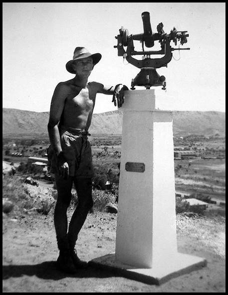
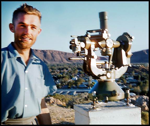
Trevor Trevillian with Natmap T4 theodolite mounted on the Fundamental Point pillar, ANZAC Hill, Alice Springs in 1950;
the pillar was constructed by the observing party just prior to use for observation. (Gus Murray image, courtesy Andrew Murray)
In 1961, National Mapping conducted a field comparison, at Khancoban, of the Wild model T4 and model T3 instruments for reading horizontal angles (Leppert, 1963). The conclusion was that the T3 model theodolite was as good for such observations as the T4 model. Ford (1979) commented Wild T3 or Tavistock azimuths are nearly as accurate as Wild T4 azimuths. Stolz (1972) concluded that the [Khancoban] tests gave the impression that there was little difference in accuracy between azimuths observed with astronomic theodolites (Type T4) and a geodetic theodolite (Type T3). However, as the sample size used to arrive at this conclusion was quite small, it must be appreciated that these indications were not necessarily conclusive. Nevertheless by then National Mapping had used the Wild model T3 theodolite exclusively for its first order geodetic work and the 1966 first order Australian Geodetic adjustment had been completed. The 1966 adjustment had included the observations at 533 Laplace stations with those up until circa 1963 observed with the Wild model T4 theodolite (after 1963 the Kern DKM3a theodolite rapidly became the instrument of choice for Laplace observations, being much lighter and compact). The Australian Geodetic Survey was considered particularly strong in azimuth due to the great number of Laplace stations along the traverse network.
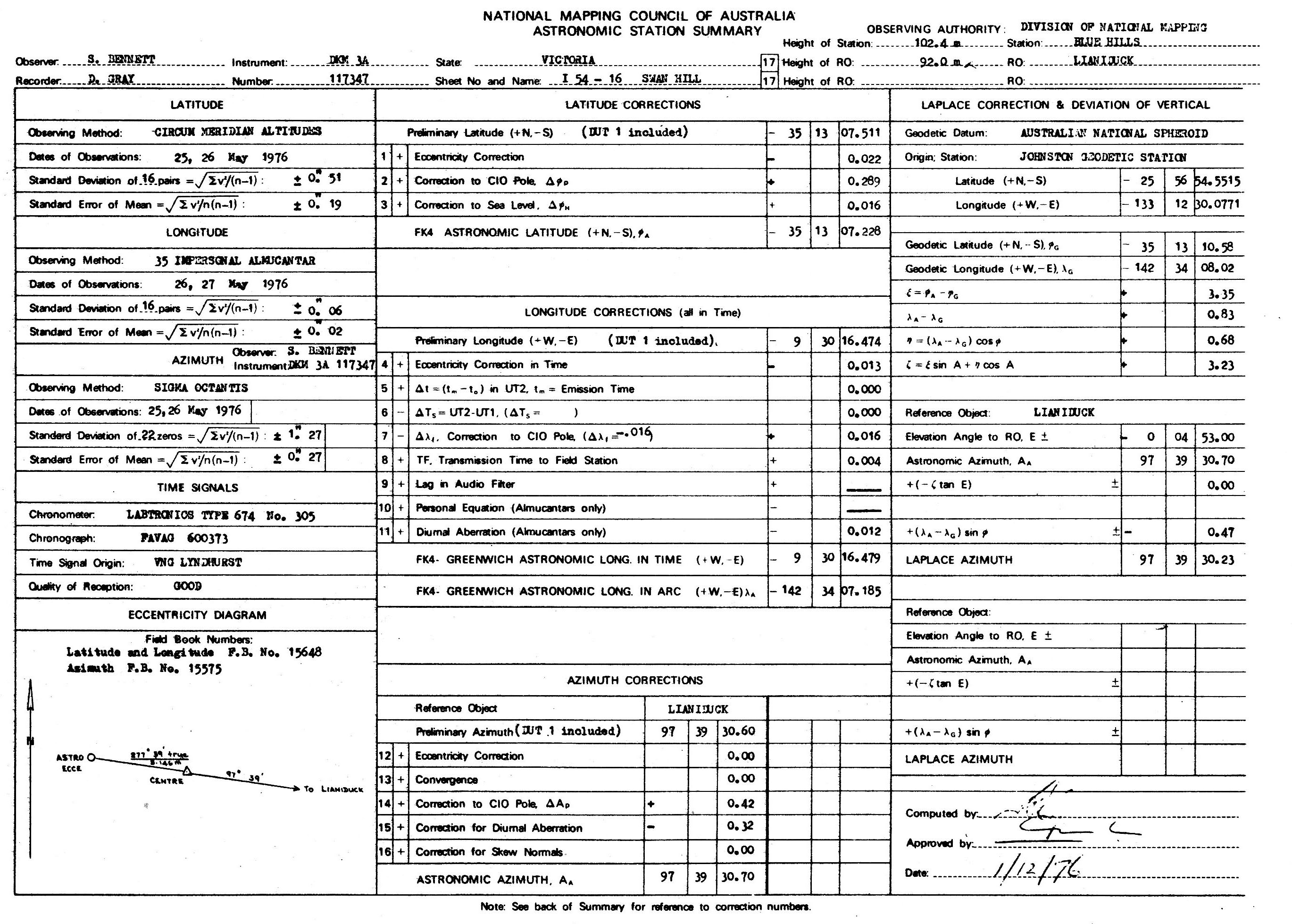
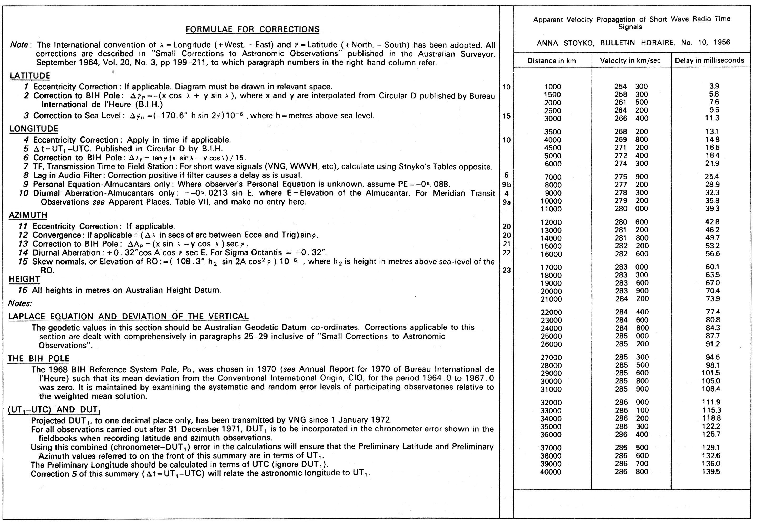
Annex B of the 1981 National Mapping Council of Australia, Standard Specifications and Recommended Practices for Horizontal and Vertical Control Surveys, contained a sample Astronomic Station Summary showing a sample Laplace observation methodology and reduction.
As far as it is known four Wild T4 theodolites were used in Australia as is described below. To uniquely identify each T4 instrument its serial number will be used as follows T4/12345. The copy of the Wild T4 Theodolite - Universal Instrument - Instructions for use was provided courtesy Bill Kitson and Kaye Nardella, Museum of Lands, Mapping and Surveying, Department of Natural Resources, Mines and Energy, Queensland.
Circa late 1950s photograph of Dr Peter Bardulis observing with a Wild model T4 theodolite and its timing equipment. (XNATMAP image)
Australian Owners/Operators of Wild model T4 theodolites
Division of National Mapping
T4/22675 – Of 1940s manufacture it was most likely the T4 used as early as 1950 by Natmap on Laplace work between Anzac Hill, Alice Springs to R602 north of Tennant Creek in the Northern Territory, the first such work by Natmap (Wise, 2018).
Dr Peter Bardulis also probably used this T4. In 1961, Peter undertook Laplace observations in the Northern Territory and was also involved with T4 Laplace observations at Tidbinbilla as late as 1965 and also at Parkes. At both sites the work was related to precise positioning and orientation of the then respective antennae assemblies.
T4/22675 is today with the University of Melbourne (https://infrastructure.eng.unimelb.edu.au/collection#&gid=0&pid=25 ).
T4/56091 – Of circa 1956 manufacture, Frank Johnston certainly used T4/56901 between 1958-1960 for Laplace work when on loan to Natmap from the Snowy Mountains Hydro-Electric Authority. Frank’s first Laplace observations work for Natmap in 1958 was on the geodetic survey traverse that generally runs along the Stuart Highway between Alice Springs and Darwin. During this work Frank undertook Laplace observations at seven geodetic survey stations. The first of these observations was on Anzac Hill in Alice Springs.
In 1959, Frank Johnston undertook further Laplace observations west from the Kulgera roadhouse in the south of the Northern Territory along the track from Mulga Park homestead to Giles weather station in Western Australia. Then he continued west along the so called Gunbarrel Highway geodetic traverse between the Giles weather station and Carnegie homestead in Western Australia. He completed his westward work at Wiluna. Turning north he completed his Laplace observation program from the Carnarvon Range to Roy Hill (The Carnarvon Range was to the west of the Canning Stock Route north of Wiluna and Roy Hill homestead was on the present day Marble Bar road, previously part of the Great Northern Highway, to the north of the present day Newman mining town).
From Roy Hill, Frank proceeded to the west coast and then travelled to Halls Creek. From here Frank carried out further Laplace observations at survey stations along the geodetic survey traverse that ran from Halls Creek to Aileron. To access these stations that were beaconed and observed in 1958, Frank travelled down the Tanami Track between Halls Creek and Alice Springs. During July-August 1960, Frank undertook Laplace astronomical observations for Natmap in Victoria and western New South Wales with then fellow Snowy Mountains Authority surveyor Klaus Leppert. This 1960 Laplace observation work was in the Mildura, Broken Hill and Tibooburra areas.
Michael Roughan McMullen recalled that around 1958 he undertook Laplace observations, at at least 4 existing stations, with a Wild T4 theodolite between Marble Bar and Derby across desert country. From a conversation with Geoffrey Higham, McMullen, a former Western Australia Lands and Survey Department surveyor, was articled to the Surveyor General, then Vernon Fyfe, qualifying as a licensed surveyor in 1955 and remaining with Lands and Surveys until 1960. The T4 and timing equipment were provided by the Commonwealth along with some notes from Dr Bardulis. A Jake (or Jack) Hocking came across and did trial runs with the equipment at the old Perth Observatory (the T4 was likely to have been one owned by Natmap given that the Hocking mentioned was likely to have been Natmapper David Hocking.)
With one of Natmap’s T4s, John Groenewald (2014) on transfer from the Snowy Mountains Hydro-Electric Authority to Natmap, spent the last half of 1963 initially at Parkes at the radio telescope where he did some Laplace observations. Then in August 1963 he set off with 3 field assistants in two trucks to do more Laplace observations across the Nullarbor; starting near Watson working along the railway line and ending close to Kalgoorlie in early December.
As well as Natmap’s T4 use in the 1950s, Laplace work continued during the 1960s with people such as Gerry Cruickshank and Adrian Roelse etc. During 1961 Laplace observations with the T4 were taken along the traverses between Mataranka and Powell Creek, Northern Territory and Giles and Young Range, Western Australia.
T4/56091 is today with the Museum of Lands, Mapping and Surveying, in Brisbane.
Frank Johnston with Wild model T4 theodolite mounted on the Fundamental Point pillar, ANZAC Hill, Alice Springs in 1958. (Frank Johnston image)
Snowy Mountains Hydro-Electric Authority
T4/37448 – Acquired in 1956, this Wild T4 was used initially for 'shaft plumbing', a specialist term for orienting underground survey networks. One of the important surveying tasks was to precisely align underground tunnelling operations so that tunnels started from two widely separated ends would meet up accurately. The most important of these was the long tunnel that was driven 14 miles from Eucumbene Reservoir to the power station site on the Tumut River. An intermediate shaft was sunk at Happy Jacks so that tunnelling could be carried out on four faces. The task was to orient the underground operations by getting accurate surveys down a 10 metre diameter shaft 100 metres deep-. Three methods were used - two optical methods, one using the T4 and the other using the T3. The other was the standard method of suspending two piano wires down a shaft and aligning surface and underground surveys to the plane of the wires. All these methods proved to be highly successful, with the final breakthrough being made within a few centimetres.
While with the Snowy Mountains Hydro-Electric Authority, before joining National Mapping, Frank Johnston used their Wild T4 theodolite to determine the impact that plumb line deviations had on the azimuth of the Scheme’s tunnels.
As indicated in the Snowy Mountains Hydro-Electric Authority Annual Reports for 1961 and 1962, when winter curtailed their T4 observing activities in the Snowy Mountains, a survey party and a Wild T4 Astronomical Theodolite were seconded to National Mapping for Laplace work.
Between 1954-1959, George Bennett worked as a surveyor with the Snowy Mountains Hydro-Electric Scheme. In 1957 as part of International Geophysical Year activities, George and his T4 theodolite was seconded to the Division of National Mapping, for three months, to make precise astronomical observations at the Long Range Weapons Establishment (Woomera rocket range) in South Australia. This Establishment was a joint project by the British and Australian governments.
Groenewald (2014) recalled that with the Authority’s T4, he was seconded to National Mapping and spent two months carrying out Laplace observations at points between Toowoomba and Ayr in Queensland, in 1962.
As mentioned above, in 1961, Natmap used two T4s (37448 and 56091) in tests at Khancoban (Leppert, 1963).
T4/37448 is now owned by the University of NSW but is on display at the Visitors Centre at Cooma (https://vm.civeng.unsw.edu.au/surveying/f_pall/html/t21.html).
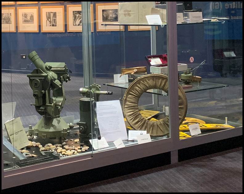
Original Snowy Mountains Hydro-Electric Authority Wild model T4/37448 theodolite on show at Cooma (courtesy Phil Bannister, 2021).
The Wild T4 theodolite is left of frame, a half hidden Wild T3 theodolite is centre frame, behind the Jenoptik Koni level, and the circular object right, is a wound steel band in its protective carrier.
Royal Australian Survey Corps
T4 (serial number still to be determined) - RA Survey’s instrument is said to have been used in the Laplace Astronomical Observations covering all of Australia and Papua & New Guinea.
Richard Jackson-Hope recalled that he was a member of a field party using their Wild model T4 theodolite on the 1960 Tennant Creek, Northern Territory to Richmond, Queensland Laplace survey with Joe Farrington as the main observer and Mal Hayes and John Van de Graaff as assistant observers and time keepers. In 1961 he was also involved with Laplace observations north of Port Moresby, and around the Fly River region of Papua New Guinea.
Richard Jackson-Hope photographs of (left, L-R) Mal Hayes and Joe Farrington at Laplace station outside Richmond, Queensland, and (right) light for astronomical azimuth party Fly River, Papua New Guinea.
Phil Bannister reported that the RA Survey’s T4, originally housed at the RA Survey Museum, Steele Barracks, Liverpool, NSW, was moved with the museum to Holsworthy as part of the School of Military Engineering. Phil kindly attempted access to Holsworthy, but COVID restrictions prevented any progress. If at some future time details of the RA Survey’s T4 come to light this article will then be updated.
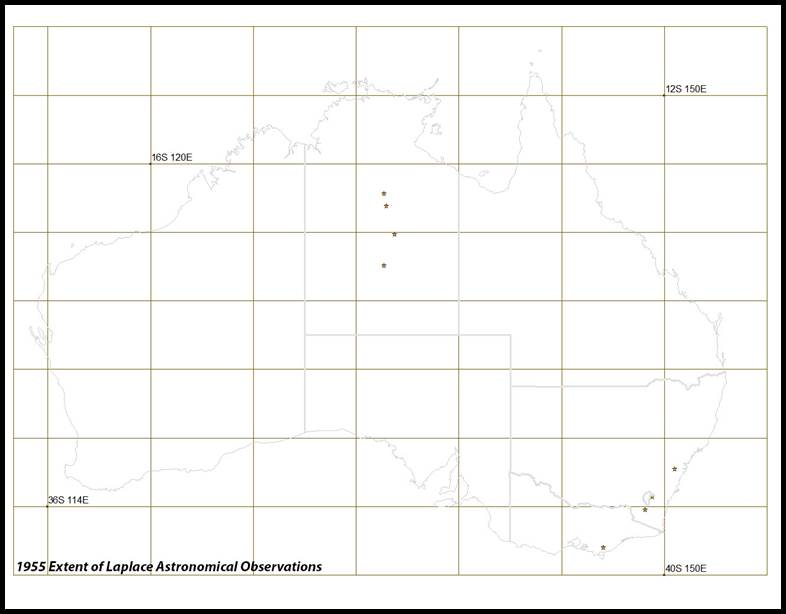
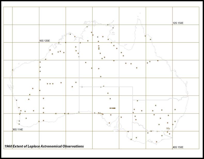
Map showing Laplace stations observed with a T4 theodolite as at 1960 and locations mentioned in above text.
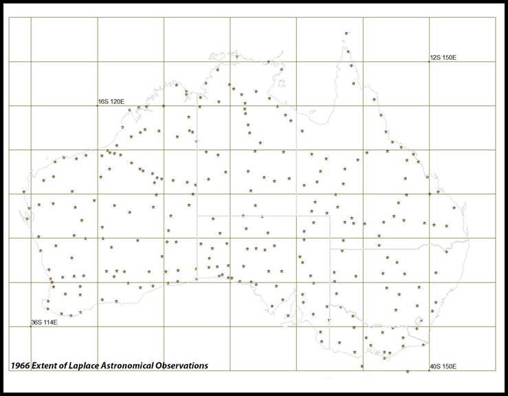
Map showing Laplace stations as at 1965 and locations mentioned in above text.
(a significant number of these Laplace observations would have been taken with the Wild T4 theodolite but some observations were acquired with Kern and Tavistock instruments).
Closing remarks
The fact that these four Wild model T4 theodolites still exist today allowed their use to be documented in at least some detail. Despite these T4 theodolites being operational for some 25 years during which time they were used for around 1 000 plus Laplace observations, there is little recorded about their role. Given the quoted importance of Laplace observations in the quality of the 1966 Geodetic Adjustment of Australia and that the majority of the Laplace observations used to control the adjustment were observed with a T4 theodolite, this article ultimately recognises the important role in the surveying and mapping of Australia of the Wild model T4 theodolite.
Acknowledgements
I am grateful to ex-Royal Australian Survey Corps member Phil Bannister for his efforts in trying to locate the RASC T4 at Holsworthy so that its details could be included in this article. Phil also visited Cooma to see the T4 originally owned by the Snowy Mountains Hydro-Electric Authority and provided the photograph and text included above. Other helpful ex-RASC members included Peter Jensen, Bob Skitch, and Richard Jackson-Hope, who provided operational details. Bill Kitson and Kaye Nardella of the Museum of Lands, Mapping and Surveying, Queensland, kindly provided details of the ex-Natmap Wild T4 theodolite S/N:56901, including a copy of the accompanying User Manual. Former Natmappers Frank Leahy and Laurie McLean provided additional input.
Sources
Anonymous (1943), A New Theodolite by Wild, Empire Survey Review, Vol.7, No.49, pp.137-138.
Ford Reginald Arthur (1979), The Division of National Mapping’s Part in the Geodetic Survey of Australia, The Australian Surveyor Vol.29, Nos.6,7 and 8, 1979, accessed at : http://www.xnatmap.org/adnm/ops/prog/rafgeosvy/index.htm
Groenewald, PJL (John) (2014), My Time In Australia 1961-4, Una Voce, Journal of the Papua New Guinea Association of Australia Inc., 2014, No.1, pp.37-39, accessed at : https://pngaa.org/ArchivedUV/J2014-03.pdf
Hotine, Martin (1929), Calibration of Surveying Cameras, Professional Papers of the Air Survey Committee - No. 5, H.M. Stationery Office, London, Chapters 1 and 4.
Husti, GJ (1971), The Twin Laplace Point Ubachsberg-Tongeren, Applying the Black Method, Netherlands Geodetic Commission, Publications on Geodesy, New Series, Vol.4, No.1, WD Meinema NV, Delft, Netherlands.
Johnson, Howard Angas (1962), First Order Angular Control, Presented, 6th Australian Survey Congress, Adelaide, accessed at : http://www.xnatmap.org/adnm/ops/specs/foac.htm
Leppert, Klaus (1963), Report on the Khancoban Azimuth Test of the accuracy obtainable with Wild T4 and T3 Theodolites, National Mapping Technical Report 2, accessed at : http://www.xnatmap.org/report_tdnm/Khancoban%20test%2002.pdf
Leppert, Klaus (1973), Geodesy in Australia, 1956-72, Proceedings 16th Australian Survey Congress, Canberra, pp.A1-A6.
McLean, Lawrence William (2017), Frank Johnston National Mapping Staff Surveyor 1971-1974, accessed at : http://www.xnatmap.org/adnm/people/aabout/frankjohnston/FLJ.htm
McLean, Lawrence William (2017), Peter Bardulis, accessed at : http://www.xnatmap.org/adnm/people/aassocs/Frank%20J/bardulis.htm
Murphy, Brian Anthony John (2020), Personal communication.
National Mapping Council of Australia (1953), Standard Specifications for Horizontal and Vertical Control, NMO/53/11.2, accessed at : http://www.xnatmap.org/adnm/ops/specs/HnV%20SPECS%20NMC%201953.pdf
National Mapping Council of Australia (1981), Standard Specifications and Recommended Practices for Horizontal and Vertical Control Surveys, Special Publication 1 (Third edition), accessed at : http://www.xnatmap.org/report_tdnm/sp1%20hnv%20svy%20specs.pdf
Royal Australian Survey Corps Association (2009), Royal Australian Survey Corps Museum Update, NEWS LETTER NUMBER 3, pp.4-8, 2009, accessed at : http://rasurvey.org/NSWNewsletters/Aug%202009.pdf
Royal Australian Survey Corps (2021), Personal communications with Peter Jensen, Phil Bannister (who arranged to visit Holsworthy and obtained details of the RASC T4) and Richard Jackson-Hope (who provided operational details).
Snowy Mountains Hydro-Electric Authority (1962), Thirteenth Annual Report for the year ended 30 June, 1962, pp.35, accessed at : https://parlinfo.aph.gov.au/parlInfo/search/display/display.w3p;query=Id%3A%22publications%2Ftabledpapers%2FHPP032016007641_2%22;src1=sm1
Spriggs, Robert M (1964), Correlation of Data from Various Methods of Aerial Camera Calibration, 10th Congress of the International Society of Photogrammetry, Lisbon, 10 pages.
Stolz, Art (1972), Three-Dimensional Cartesian Co-ordinates of Part of the Australian Geodetic Network by the Use of Local Astronomic Vector Systems, PhD Thesis, accessed at : http://unsworks.unsw.edu.au/fapi/datastream/unsworks:65720/SOURCE01?view=true
Wise, Paul Joseph (2017-2018), National Mapping’s First Laplace Field Work, accessed at : http://www.xnatmap.org/adnm/ops/proj/dnm_laplace2.htm
Determination of Focal Length and Lens Distortion from Aerial Camera Calibration using a Theodolite
Documented in Hotine (1929) this method is a variation of a methodology proposed by Henry Georges Fourcade (1865-1948). As can be seen in the images below, essentially an illuminated engraved plate was rigidly attached to the camera’s focal plane AB. The theodolite is fixed at T. A prism is at P on an arm that rotates about point C. The pentagonal prism P gave a constant deviation of approximately 90°. Movement of this prism enabled different graduations on the engraved plate to be sighted. Using sequential adjustments of the prism and its arm, the angle between the camera lens nodal line NM and any graduation at AB, may be read by the theodolite. The resolution of the T4’s horizontal circle allowed these angles to be read to an accuracy ultimately giving the required camera constants to a factory laboratory order of accuracy.
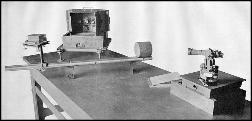
Arrangement of equipment for the calibration of an aerial camera using a theodolite after Hotine (1929).
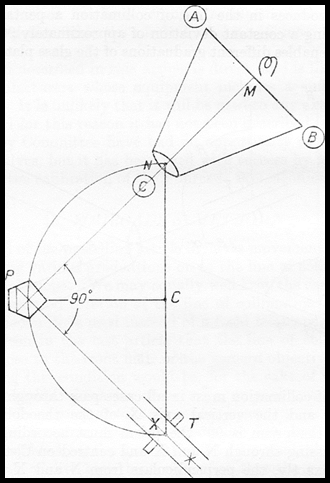
Schematic of components
A more modern approach was documented by Ordnance Survey, UK, in a 1968 paper by Sly, The Calibration of Aerial Survey Cameras, in The Photogrammetric Record, Vol.6, Issue.31, pp.59-74. In their approach the camera was mounted above the T4 whereby the ability of the T4 to be easily read while at zenith could be used.