Australia’s Contribution to the PAGEOS Project
The PAGEOS (Passive Geodetic Earth Orbiting Satellite) spacecraft was a 30.48 metre inflatable sphere, that carried no instrumentation. It was the second NASA satellite in the National Geodetic Satellites Program. PAGEOS 1 was made up of 84 gores and 2 pole caps of 0.0127 millimetre aluminised Mylar film. The gores were 48 metres long with a maximum width of 1.24 metres and the pole caps were 1.02 metres in diameter. The primary purpose of the satellite was to provide a tracking target for geodetic purposes by providing a reflecting light source whose brightness was relatively independent of observer-satellite-sun phase angle. A short explanatory video may be viewed via this link.
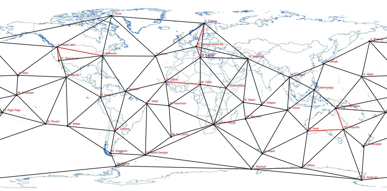
Figure 1 : The PAGEOS geodetic network with its 45 ground stations (Number and Name) and the established baselines in red.
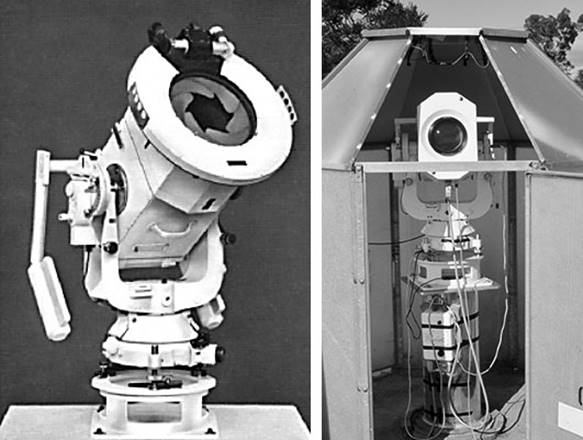
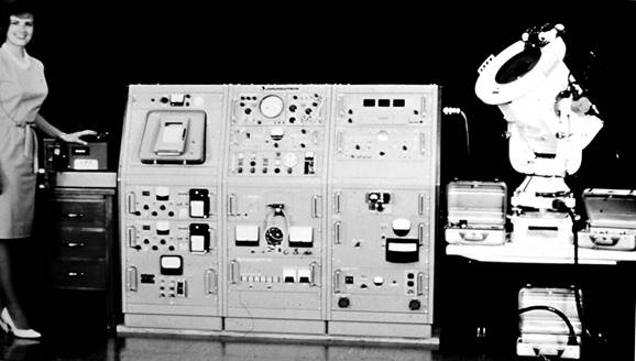
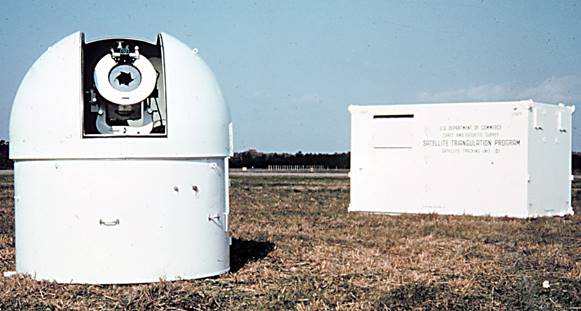
Figure 2 : (Top) Wild BC-4 Ballistic Camera static and on-site; (Centre) instrument system used in the PAGEOS satellite triangulation program consisting of the electronic synchronization unit in the large console and the BC-4 camera; (Bottom) typical site configuration with the BC-4 camera astrodome and demountable which housed the electronic synchronization unit (courtesy NOAA's Geodesy Collection).
PAGEOS was the earth orbiting target in a global cooperation Weltnetz der Satellitentriangulation (Worldwide Satellite Triangulation Network) planned by Hellmut Schmid (Schmid, 1974). The final network of 45 ground stations, listed in Annexure A, encompassed the globe with each ground station comprising instrumentation as shown in Figure 2 above and described at Annexure B. Note that some documentation says there were 46 stations. This number stems from the fact that after observing commenced the camera on Wake Island was moved some 50 metres in September 1967 due to flooding. This new site was given another number to avoid confusion. Schmid’s 1974 results list only 45 stations.
At suitable times, applicable ground stations simultaneously photographed the satellite against the star background. Photographing PAGEOS in at least two different parts of the sky, as seen from each pair of ground stations, established a direction from one station to the other. If three or more ground stations were involved at the same time, a network of directions could be established to determine, except for scale, the relative locations of the ground stations (Corpacius, 1964). From this stellar triangulation, the relative locations of ground stations 3000 to 5000 kilometres apart were obtained. To provide and maintain scale throughout the network, highly precise baseline distances were required within the network.
In this global triangulation, baselines on four continents were established; North America from Beltsville in Maryland east to Moses Lake in Washington State and south to Wrightwood, California; in Europe from Tromso in Norway south to Hohenpeissenberg in Germany and onto Catania in Italy; in Africa from Dakar east to Fort-Lamy, Chad; and in Australia from Perth, Western Australia east to Culgoora in NSW and north to Thursday Island off Cape York. Figure 1 above shows the 45 ground stations (Number and Name) and the associated network with the established baselines in red.
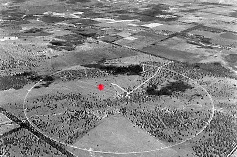
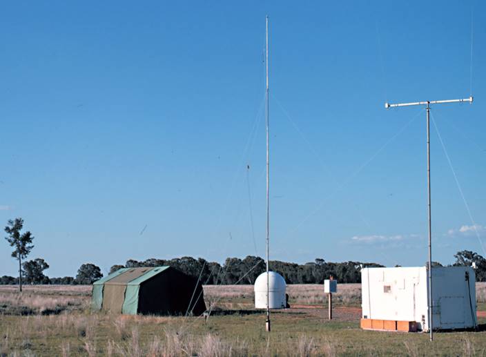
Figure 3 : (Left) Wild BC-4 site (red star) at Culgoora in then CSIRO Radiophysics Laboratory Radioheliograph compound (courtesy Goss (2013)) and right the installation at Culgoora showing centre the BC-4 camera astrodome and to its right the demountable which housed the electronic synchronization unit (courtesy NOAA's Geodesy Collection).
From 1967 to 1970 the majority of National Mapping’s geodetic resources went into refining existing surveys to generate these two baselines as shown in Figure 4 below. The Perth-Culgoora baseline comprised 162 surveyed segments with a final computed length of 3,692 kilometres and the Culgoora-Thursday Island baseline comprised 102 survey segments with a final computed length of 2,910 kilometres.
National Mapping’s activities are variously described in :
|
- |
Technical Report No. 11, Two Australian baselines for the PAGEOS world triangulation, by Klaus Leppert, 1972. |
|
- |
Chapter 17, The Division of National Mapping’s Part in the Geodetic Survey of Australia, in The Australian Surveyor, June, September and December 1979: Vol.29, No.6, pp.375-427; Vol.29, No.7, pp.465-536; Vol.29, No.8, pp.581-638, by Reg Ford, 1979. |
|
- |
Recollections by Andrew Porteous. |
|
- |
Use of the MRA4 Tellurometer on the Swedish-Norwegian section of the Tromso-Catania PAGEOS baseline describing part of the European contribution to the PAGEOS project. |
|
- |
Earth Parameters From Global Satellite Triangulation And Trilateration, Mueller, II (1973), Proceedings Symposium on Earth's Gravitational Field and Secular Variations in Position, UNSW, describing the results obtained from 159 station global satellite triangulation and trilateration (including Baker-Nunn, BC-4, PC-1000 camera observations, SECOR, C-Band radar and EDM distance measurements) which indicate differences in the semidiameter and orientation of the Earth compared to results obtained from dynamicsatellite solutions. |
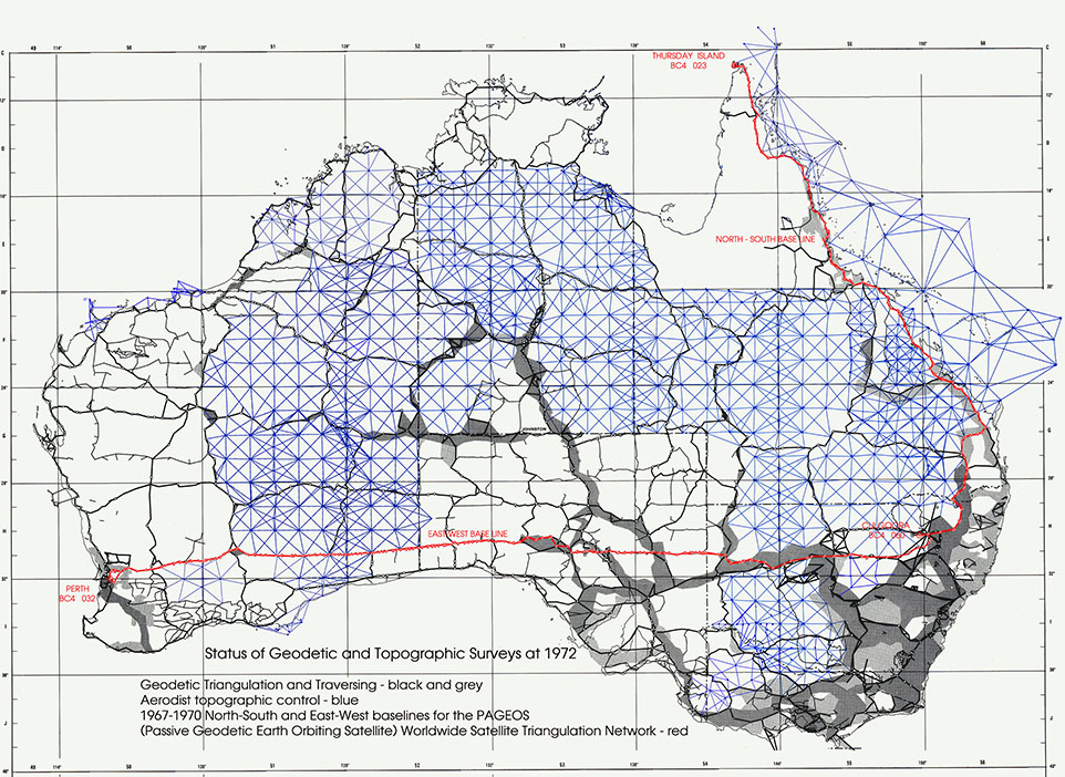
Figure 4 : The survey route of the Australian baselines (after Leppert, 1973).
Finished in 1974, the PAGEOS network connected stations previously on seven different geodetic ellipsoids (International, Clarke 1866 and 1880, South American, Bessel, Everest, and Australian National) with an accuracy of better than 20 metres. A best fitting global ellipsoid was defined from these data with an equatorial radius of 6,378,130 metres. In 1984 when the GPS ellipsoid was determined at 6,378,137 metres the 1974 work was shown to produce a value to better than 1 part per million.
Barlier and Lefebvre, in their 2001 paper A New Look at Planet Earth : Satellite Geodesy and Geosciences, are less enthusiastic about the PAGEOS results. Although stating that the geocentric positions of the 45 stations published were considered at this time as making one of the first homogeneous global Earth reference systems, they also say the project was in fact a dead-end. Firstly, the 10-15 metre accuracy was not good enough, but the major disadvantage was that this new reference system was not accessible to the common user!
A report in September 2016 revealed that although PAGEOS suffered partial disintegration in July 1975 and a further break-up in 1976, what was thought to be the principal part of the satellite re-entered the earth’s atmosphere on 2 September, 2016 after lasting over 50 years in orbit.
Compiled by Paul Wise, December 2016
References
Barlier, Francois and Lefebvre, Michel (2001), A New Look at Planet Earth : Satellite Geodesy and Geosciences, The Century of Space Science, Kluwer Academic Publishers, accessed at : http://www.ipgp.fr/~tarantola/Files/Professional/Teaching/Seminar/Texts/Barlier-Lefebvre.pdf
Corpacius, AJ (1964), The Stellar Triangulation with Photographic Observations, Space Science Reviews, Vol.4, No.2, pp.236-261, accessed at : http://adsabs.harvard.edu/full/1965SSRv....4..236C
Goss, WM (2013), Making Waves, Springer-Verlag.
Leppert, Klaus (1973), Geodesy in Australia, 1956-72, Technical papers presented at 16th Australian Survey Congress, Canberra, 1973, pp.A1-A6.
National Aeronautics and Space Administration (1971), NASA Directory of Observation Station Locations, Vol.2 (Edn.2), NASA-TM-X-68819, NASA Goddard Space Flight Center accessed at : https://ntrs.nasa.gov/search.jsp?R=19720012596
Schmid, Hellmut H (1974), Worldwide Geometric Satellite Triangulation, Journal of Geophysical Research, Vol.79, No.35, pp.5349-5376.
Schmid, Hellmut H (1974), Three-Dimensional Triangulation with Satellites, NOAA Professional Paper 7, National Oceanic and Atmospheric Administration (NOAA).
Annexure A
The network’s 45 ground stations listed by Number with Name, approximate geographical coordinates, original Datum and Ellipsoid
|
Station Number & Name |
Latitude |
Longitude |
Datum & Ellipsoid |
|||
|
1 |
Thule, Greenland, Denmark |
76.5 N |
068.5 W |
Qornoq |
International |
|
|
2 |
Beltsville, Maryland, USA |
39.0 N |
076.8 W |
North American 1927 |
Clarke 1866 |
|
|
3 |
Moses Lake, Washington, USA |
47.2 N |
119.3 W |
North American 1927 |
Clarke 1866 |
|
|
4 |
Shemya, Alaska, USA |
52.7 N |
174.1 E |
North American 1927 |
Clarke 1866 |
|
|
6 |
Tromso, Norway |
69.7 N |
018.9 E |
European |
International |
|
|
7 |
Lajes AFB, Terceira, Azores |
38.8 N |
027.1 W |
SW Base |
International |
|
|
8 |
Paramaribo, Surinam |
05.5 N |
055.2 W |
Provisional South American 1956 |
International |
|
|
9 |
Quito, Ecuador |
00.1 S |
078.4 W |
South American 1969 |
South American |
|
|
11 |
Maui, Hawaii, USA |
20.7 N |
156.3 W |
Old Hawaiian |
Clarke 1866 |
|
|
12 |
Wake Island, USA |
19.3 N |
166.6 E |
Astro 1952 |
International |
|
|
13 |
Kanoya, Kyushu, Japan |
31.4 N |
130.9 E |
Tokyo |
Bessel |
|
|
15 |
Mashad, Iran |
36.2 N |
059.4 E |
European 1950 |
International |
|
|
16 |
Catania, Sicily, Italy |
37.4 N |
015.0 E |
European |
International |
|
|
19 |
Villa Dolores, Argentina |
31.9 S |
065.1 W |
South American 1969 |
South American |
|
|
20 |
Easter Island, Chile |
27.2 S |
109.4 W |
Astro 1967 |
International |
|
|
22 |
Pago Pago, Samoa, USA |
14.3 S |
170.7 W |
Samoa 1962 |
Clarke 1866 |
|
|
23 |
Thursday Island, Australia |
10.6 S |
142.2 E |
Australian National |
Australian National |
|
|
31 |
Invercargill, New Zealand |
46.4 S |
168.3 E |
Geodetic 1949 |
International |
|
|
32 |
Perth, Australia |
31.9 S |
116.0 E |
Australian National |
Australian National |
|
|
38 |
Revilla Gigedo Island, Mexico |
18.7 N |
111.1 W |
Isla Socorro Astro |
Clarke 1866 |
|
|
39 |
Pitcairn Island, UK |
25.1 S |
130.1 W |
Pitcairn Astro 1967 |
International |
|
|
40 |
Cocos Island, Australia |
12.2 S |
096.8 E |
Anna Astro 1965 |
Australian National |
|
|
42 |
Addis Ababa, Ethiopia |
09.0 N |
038.7 E |
Adindan |
Clarke 1880 |
|
|
43 |
Cerro Sombrero, Chile |
52.8 S |
069.2 W |
Provisional South Chile 1963 |
International |
|
|
44 |
Heard Island, Australia |
53.1 S |
073.7 E |
Astro 1969 |
International |
|
|
45 |
Mauritius, Mascarene |
20.4 S |
057.7 E |
Le Ponce Astro |
Clarke 1880 |
|
|
47 |
Zamboanga, Philippines |
06.9 N |
122.1 E |
Luzon |
Clarke 1886 |
|
|
50 |
Palmer Station, Antarctica, USA |
64.7 S |
064.4 W |
Palmer Astro 1969 |
Clarke 1880 |
|
|
51 |
Mawson Station, Antarctica, Australia |
67.6 S |
063.0 E |
Astro 1969 |
||
|
52 |
Wilkes Station, Antarctica, Australia |
66.2 S |
110.6 E |
Astro 1969 |
||
|
53 |
McMurdo Station, Antarctica, USA |
77.8 S |
166.7 E |
Camp Area Astro 1961-1962 USGS |
International |
|
|
55 |
Ascension Island, UK |
08.0 S |
014.3 W |
Ascension Isl. 1958 |
International |
|
|
59 |
Christmas Island, USA |
02.0 N |
157.4 W |
Christmas Isl. 1967 Astro |
International |
|
|
60 |
Culgoora, NSW, Australia |
30.3 S |
149.6 E |
Australian National |
Australian National |
|
|
61 |
South Georgia Island, UK |
54.3 S |
036.5 W |
Astro |
International |
|
|
63 |
Dakar, Senegal |
14.7 N |
017.5 W |
Adindan |
Clarke 1880 |
|
|
64 |
Fort-Lamy, Chad |
12.2 N |
015.0 E |
Adindan |
Clarke 1880 |
|
|
65 |
Hohenpeissenberg, Germany |
47.8 N |
011.0 E |
European |
International |
|
|
67 |
Natal, Brazil |
05.9 S |
035.4 W |
South American 1969 |
South American |
|
|
68 |
Johannesburg, South Africa |
25.9 S |
027.7 E |
Buffeisfont |
Clarke 1880 |
|
|
69 |
Tristan da Cunha Island, UK |
37.0 S |
012.3 W |
Astro 1968 |
International |
|
|
72 |
Chieng Mai, Thailand |
18.8 N |
099.0 E |
Indian |
Everest |
|
|
73 |
Diego Garcia, Chagos, Mauritius |
07.3 S |
072.5 E |
1969 Astro |
International |
|
|
75 |
Mahe, Seychelles, UK |
04.7 S |
055.5 E |
Mahe 1971 |
Clarke 1880 |
|
|
111 |
Wrightwood, California, USA |
34.4 N |
117.7 W |
North American 1927 |
Clarke 1866 |
|
Annexure B
The Wild BC-4 Ballistic Camera
The Wild BC-4 Ballistic Camera combined a modified Wild RC-5 aerial camera with a modified T-4 astronomical theodolite mount. An Astrotar lens of 305 millimetre focal length was originally used, but by the end of the world observation program in November 1970 all cameras except one had been equipped with a 450 millimetre Cosmotar (Astrotar-type) lens for an optimum combination of resolution and field of view.
The camera was stationary during exposure, so that star images were recorded as interrupted arcs across the photographic plate. Three rotating disk shutters were synchronized through a high precision gearing system. An external capping shutter was used to chop star trails for calibration before and after the satellite was tracked. Precise epoch time was established at each field station by transporting portable crystal clocks, or by relay through satellites, and was maintained through the use of a local oscillator and VLF transmissions. Timing accuracy for satellite images was ± 100-150 microseconds.
The 18 centimetre square image corresponded to a 22° square field of view (33° on the 305 mm model). The maximum aperture was f/3.4. Exposures were made on 215 x 190 x 6 millimetre glass plates. Stars of 8th and 9th magnitudes could easily be identified on the plates, but those of magnitude 6 and 7 were preferred because of the greater accuracy of their catalogue information.
The system weighed 650 pounds and was transportable. For observing the system was mounted on a fixed pillar in a small astrodome.